Showing 2031 items
matching non-ferrous
-
 Eltham District Historical Society Inc
Photograph, Jim Connor, Avenue of Honour, Main Road, Eltham, 14 Jan 2017
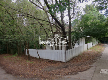
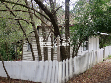
Eltham Gateway, The old Bootmaker's Cottage adjacent to Whitecloud Cottage, 701 Main Road, Eltham The bootmaker's shop was operated by John Henry (Harry) Clark from about 1930. Clark was originally a photographer along with his brothers William (Will) Charles Clark and Clement Kent Clark. They operated as Clark Bros Photographers based at 25 Thomas Street, Windsor (Prahran) from about 1895 to 1915 at which point the premises was demolished.. Brother Clement died in 1912. By 1916 Harry was living and working as a photographer in Eltham and was recorded on the electoral rolls as a photographer up to and incliiding at least 1928. By 1931 he had changed proession to Bootmake and again continued on Main Road, Eltham South as a Bootmake at least until 1954. He died at St Vincent'e Hospital in Dec 1956. It is believed non of the brothers married. Whilst very little public record exists og Harry in the papers either as a photographer or bootmaker, one incident was reported in 1935 when he witnessed a girl on a bike come crashing down Main Road and into the pond next to his shop.Tomorrow's history documented todayeltham, jim connor collection, main road, eltham gateway, avenue of honour, dalton street, wingrove park trail, bootmakers cottage -
 Eltham District Historical Society Inc
Photograph, Jim Connor, Avenue of Honour, Main Road, Eltham, 14 Jan 2017
Eltham Gateway, The old Bootmaker's Cottage adjacent to Whitecloud Cottage, 701 Main Road, Eltham The bootmaker's shop was operated by John Henry (Harry) Clark from about 1930. Clark was originally a photographer along with his brothers William (Will) Charles Clark and Clement Kent Clark. They operated as Clark Bros Photographers based at 25 Thomas Street, Windsor (Prahran) from about 1895 to 1915 at which point the premises was demolished.. Brother Clement died in 1912. By 1916 Harry was living and working as a photographer in Eltham and was recorded on the electoral rolls as a photographer up to and incliiding at least 1928. By 1931 he had changed proession to Bootmake and again continued on Main Road, Eltham South as a Bootmake at least until 1954. He died at St Vincent'e Hospital in Dec 1956. It is believed non of the brothers married. Whilst very little public record exists og Harry in the papers either as a photographer or bootmaker, one incident was reported in 1935 when he witnessed a girl on a bike come crashing down Main Road and into the pond next to his shop.Tomorrow's history documented todayeltham, jim connor collection, main road, eltham gateway, avenue of honour, dalton street, wingrove park trail, bootmakers cottage -
 Kiewa Valley Historical Society
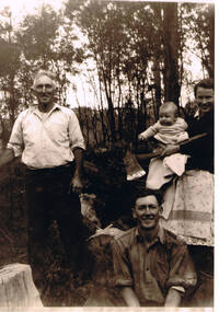
Photograph of Kiewa Valley Pioneer Family, Three Generations of Kiewa Valley Pioneer Family (Coopers), late 1900s'
This historical family photograph spans three generations of the Cooper Family, a pioneer family, still residing in the Kiewa Valley. The large axe held by Pat was a handy tool for pioneer families to chop down trees for land clearing, building sheds and fences, outhouses and fire wood. This photograph was taken during a time where both male and females did some heavy lifting and processing. The rural sector at this point in time was physically a hard location for both sexes. The segregation of the sexes into specific job categories was some times non existent although household "chores" was in the main a woman's domain. The rural sector was in this point of time one which women were highly respected and the unwritten law of providing "assistance" and "reverence" by men in such actions as, socially opening doors, tipping the cap, offering a sturdy arm for support and refraining from doing or saying anything "uncouth" in a woman's presence. It was in a time when women's liberation was just starting to grow strength. Rural areas, on the hole, took longer to interfuse "city" hatched norms of behaviour. This photograph of a pioneer family still residing in the Kiewa Valley demonstrates not only the close protective environment that the valley has on all its inhabitants but also the close bonding that neighbors have towards each other. The term "God's gifted country" fits warmly with all the settlements in the valley. The relatively isolated (physically, visually and communications wise) has since post World War II been whittled away by faster and vastly improved communications with "the outside" world. The strength of commitment to the rural life can be seen in the faces of the family members in this photograph. The proud heritage is displayed without any external pressure. This large black and white family photograph is a reproduction on Fujicolor Crystal Archive Paper manufactured by Fujifilm. It is 200gsm matt finished paper with no borders. On the reverse side, written in pencil "Ted Cooper sitting aged 24-25, Pat Amery (Ted's youngest sister) holding Ted's eldest son Doug and Ted's father John Franklin Cooper(22-8-1892)"john cooper, ted cooper, pat amery, doug cooper, pioneer family kiewa valley -
 Eltham District Historical Society Inc
Photograph, Liz Pidgeon, Heritage Excursion; East of Eltham, 6 Sep 2014, 20 May 2017
Newsletter No. 218, September 2014 September Excursion - East of Eltham Walk In Newsletter No. 197, March 2011, there was a brief history of Crown Allotment 15 Section 5 Parish of Nillumbik (CA 15) a parcel of land of a quarter of a square mile extending from Eucalyptus Road to Reynolds Road at the eastern extremity of Eltham. From the 1940s it was known as Stokes orchard. In later years it has been subdivided for residential purposes but leaving significant areas as power line and water supply reserves and bushland reserves that are habitat for the threatened For our excursion on 6th September we intend to walk through CA 15 to a bushland reserve east of Reynolds Road. The walk will traverse the boundary between suburban Eltham and the non-urban areas to the south and east. This is a pleasant walk through residential areas and bushland. Along the way we will discuss the early and more recent history of CA 15 as well as local natural history and geology. This walk is about 3.5 km in length and will take 2 to 2.5 hours. It will start at 2pm at the corner of Eucalyptus Road, Pitt Street and Nyora Road.Born Digitaleltham east, eltham district historical society, heritage excursion, activities, nyora road, reynolds road, gum tree road reserve, diosma road, stokes orchard, eucalyptus road -
 Eltham District Historical Society Inc
Photograph, Liz Pidgeon, Heritage Excursion; East of Eltham, 6 Sep 2014, 20 May 2017
Newsletter No. 218, September 2014 September Excursion - East of Eltham Walk In Newsletter No. 197, March 2011, there was a brief history of Crown Allotment 15 Section 5 Parish of Nillumbik (CA 15) a parcel of land of a quarter of a square mile extending from Eucalyptus Road to Reynolds Road at the eastern extremity of Eltham. From the 1940s it was known as Stokes orchard. In later years it has been subdivided for residential purposes but leaving significant areas as power line and water supply reserves and bushland reserves that are habitat for the threatened For our excursion on 6th September we intend to walk through CA 15 to a bushland reserve east of Reynolds Road. The walk will traverse the boundary between suburban Eltham and the non-urban areas to the south and east. This is a pleasant walk through residential areas and bushland. Along the way we will discuss the early and more recent history of CA 15 as well as local natural history and geology. This walk is about 3.5 km in length and will take 2 to 2.5 hours. It will start at 2pm at the corner of Eucalyptus Road, Pitt Street and Nyora Road.Born Digitaleltham east, eltham district historical society, heritage excursion, activities, nyora road, reynolds road, gum tree road reserve, diosma road, stokes orchard, eucalyptus road