Showing 2049 items
matching open house
-
 Bendigo Historical Society Inc.
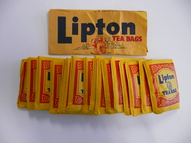
Memorabilia - LIPTON TEA BAGS
Opened packet of Lipton tea bags, contains 16 yellow tea bags and instructions sheet, packet reads 2 cups for a penny 30 tea bags only a 1d a bag.Liptons the worlds sales leaderdomestic equipment, food preparation, tea bags -
 Bendigo Historical Society Inc.
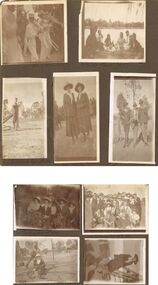
Photograph - HILDA HILL COLLECTION: BLACK AND WHITE PHOTOS, 1920
Hilda Hill collection. Combination of Sepia & Black & White Photos Total of 9. Photos. Five boys all dressed in white and wearing white boaters playing instruments in a band, left foreground Tuba, two in centre playing trombones, man in background playing smaller tuba like instrument, Clem Easter Fair procession1920. Four young ladies and four young men sharing a picnic at the lake, (Weeroona?), ladies wearing white or light coloured outfits and the men and boys all dressed in darker clothing, background left building on far side of the lake, at the lake 'Hungry' January 1920. Ken at Lockwood April 25th 1920, wearing white shirt dark waistcoat and trousers, left arm on top of gate post, two stays for the gate post and dry tree limb on ground, background open paddock with trees further in the background. Babe & Hilda at the Easter Fair 1920, Both wearing broad brimmed hats, one light the other dark, dark coat and skirt combinations with white accessories. 'the Three Graces' Queen street, April 25th 1920, 1 wearing dark suit and hat with white shirt and dark tie, centre wearing grey suit hat white shirt and dark tie also holding a ball his left hand round the shoulder of the man to his left, man on right wearing dark coat grey trousers white shirt and dark tie his left hand is holding round stick. Group of seated ladies, lady to left wearing light broad brimmed hat and white blouse holding bunch of leaves, next lady also wearing light broad brimmed hat dark dress white blouse with large collars folded over the coat lapel, and glasses, next at rear of group lady in hat white dress and dark coat left hand on shoulder of person left front of herself, This lady wearing dark wide broad brimmed hat dark coat and skirt with white blouse and also holding a bunch of leaves, last lady on right wearing a floppy brimmed hat with white blouse and dark coloured outfit with light coloured lapels, One Tree Hill April 18th 1920. Family group Lockwood April 25th 1920,some of the males are wearing hats others not, most are in dark coloured suits with or without coats, all of the ladies are wearing hats of varying kinds, all appear to have white blouses on with dark skirts or dresses, photo in open paddock with trees in the background. Girlie & Frank Queen street April 25th 1920, Girlie in foreground seated on rug of which more next to her is where Frank may sit, to her wearing glasses dark dress with white blouse and white hat, Frank wearing grey suit and hat is holding an object over the head of Girlie,background left a suitcase on the ground, centre background is a slim tree, right background house with gabled roof and bull nose verandah, high picket fence, trees on footpath. Left side buildings fronting the footpath. Babe seated on the hand rail at the bottom of wooden stair case, wearing broad brimmed hat dark dress and white blouse, shadow in foreground of the photographer and assistant, left is wire fence with wooden posts and top rail, April 1920.australia, history, post war life -
 Bendigo Historical Society Inc.
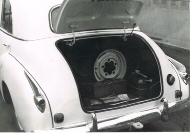
Photograph - PETER ELLIS COLLECTION: HOLDEN CAR
Black and white photograph. White car. FJ Holden, (1954-1956). Boot open spare wheel.person, individual, peter ellis car -
 Bendigo Historical Society Inc.
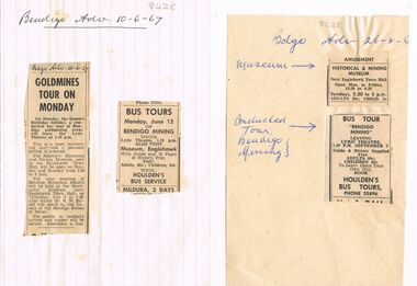
Newspaper - BENDIGO HISTORICAL SOCIETY TOURS AND MUSEUM, 16th June 1967
Two pages, advertisements from Bendigo Advertiser, 26.8.1967 and 10.6.67, glued on. Articles detail open days of Historical & Mining Museum, next Eaglehawk Town Hall, bus tour ' Bendigo Mining' (Houlden's Bus Tours) and a Bendigo gold mining areas tour. Mr. R.W. Birrell is mentioned as a speaker at the monthly meeting in July 1967, speaking on the history of the Bendigo School of Mines.Bendigo Advertiserbendigo, mining, bendigo historical society -
 Bendigo Historical Society Inc.
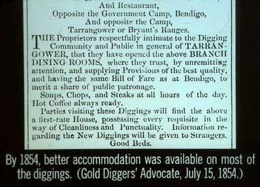
Slide - DIGGERS & MINING. STORES AT THE DIGGINGS, 15 July, 1854
Diggers & Mining. Stores at the diggings. And Restaurant, Opposite the Government Camp, Bendigo, And opposite the Camp, Tarrangower or Bryant's Ranges. The proprietors respectfully intimate to the Digging Community and Public in general of TARRANGOWER, thus they have opened the above BRANCH DINING ROOMS, where they trust, by unremitting attention, and supplying Provisions of the best quality, and having the same Bill or Fare as at Bendigo, to merit a share of public patronage. Soups, Chops, and Steaks at all hours of the day, Hot Coffee always ready. Parties visiting these diggings will find the above a first- rate House, possessing every requisite in the way of Cleanliness and Punctuality. Information regarding the diggings will be given to Strangers. Good Beds. Slide reads; By 1854, better accommodation was available on most of the diggings. (Gold Diggers' Advocate, July, 15, 1854.) Markings: 21 994.LIF. 5. Used as a teaching aid.hanimounteducation, tertiary, goldfields -
 Bendigo Historical Society Inc.
Document - BHS EXCURSION TO EAGLEHAWK AND THE WHIPSTICK 8/10/2006
Notes on the BHS Excursion to Eaglehawk and the Whipstick, Sunday 8 October 2006, prepared by Margaret Bourke. The excursion was conducted by Ray Wallace and organised by Kay McGregor. Notes give a detailed list of the places visited - Eaglehawk, Snob's Hill, Harvey Town, Whipstick, Woodvale, Red Flag Gully and Lightning Hill.bhs excursion to eaglehawk and the whipstick 8/10/2006, margaret bourke, ray wallace, kay mcgregor, national trust, lancashire open cut, joey midson, prince of wales mine, pioneer hotel, pavillion hotel, moon mine, new moon, moon sandhill, moon dams, new moon north, woodvale state school, clan mcleod pipe band, rothackers, james woods, baden-baden hotel -
 Bendigo Historical Society Inc.
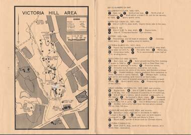
Map - VICTORIA HILL AREA
Map of Victoria Hill Area printed on yellow paper. Details of tracks, cuttings, contours (in Metres) and Anticline. Location of mines, open cuts and buildings are shown. Numbers on map are: Ballerstedt's Claim 1 - 5; North Old Chum Co. 6; Lansell's 180, 7,8,11; Battery 9.10.12; Victoria Quartz Co. 13 - 17; Rae's Open Cut and Vicinity 18 - 28, Great Central Victoria Co 29 - 36, Adventure and Advance Area and vicinity 37 - 40 and Victoria Consols Co 41.map, bendigo, victoria hill, victoria hill area, victoria consols, new chum anticline, great central victoria, rae's open cut, w rae's home, victoria quartz, ballerstedt's open cut, lansell's 180, north old chum, central nell gwynne, john brown factory, gold mines hotel, cleopatra needle type chimney, floyd's battery, ballerstedt's 24yd claim, humboldt shaft, wittscheibe's jeweller's shop, luffsman and sterry's claim, victoria hill reserve, mines dept reervation -
 Bendigo Historical Society Inc.
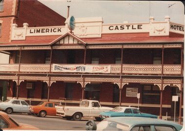
Photograph - BENDIGO HOTEL COLLECTION: LIMERICK CASTLE HOTEL, 259 WILLIAMSON STREET, BENDIGO
Colour photograph: Limerick Castle, 259 Williamson Street, Bendigo, two storey brick hotel, lace verandah on both levels. Gable in centre of top level. 'Balcony now open, food and drinks' sign on verandah top. Red corrugated iron roof on verandah. 'Limerick Castle Hotel' sign on top. Appears to be early 70's ?bendigo, hotel, limerick castle hotel -
 Bendigo Historical Society Inc.
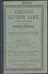
Document - Bendigo Savings Bank Passbook, 14/01/1893
In 1862 the Bendigo Penny Savings Bank was opened. It later was simply called the Bendigo Savings Bank. Ten months after its opening it reported that it had monthly deposits of 2 pounds, 12 shillings and 4 pence. (Jan 1863)Bendigo Savings Bank Passbook No. 36293 belonging to Miss Marguerite Kane. Used for deposits and withdrawals between January 1893 and November 1896. handwritten entries. Green card cover bound with cloth tape. Cover includes opening times. Rules and Regulations of Savings Banks in Victoria included at front of passbook.savings banks, passbook -
 Bendigo Historical Society Inc.
Document - Former Conrad Heinze Butcher's Shop, 1872
Source National Trust: Conrad Heinz Butchers Shop - Happy Valley Road. This building was a weatherboard cottage evidently built in three stages with the front door in the central part, planked by three paned double casements, six-paned sash windows in the rear section; front section and timber veradah with scrolled vallance. The architect and builders are unknown. The outside doors to the cellar and the simple chimney breast remain a notable feature. The original owner was Conrad Heinz a former mayor of Bendigo who with two brothers opened a butcher's shop in the building in 1872. In 1883 he moved to Mt Korong Road Iron Bark, where he carried on another thriving business and built a substantial house close by. When Conrad Heinz left Happy Valley Road, one brother had died, but his widow carried on the first butchering business with the help of a lad and one of her three daughters. The little shop and residence stood for over a century on the spot, almost untouched by modern progress. The shop was closed for 70 years at most. It was demolished about 1982.Data Forms on the house on Corner of Happy Valley Road and Wells Street, Long Gully, now demolished. Various letters to and between the Bendigo Council, the National Trust and the owners of the house.history, national trust bendigo collection, bendigo, happy valley road long gully, butcher's shop bendigo, conrad heinze -
 Bendigo Historical Society Inc.
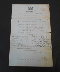
Legal record - Abbott Collection: Legislative Assembly nomination form
Robert Burrowes was born in Canada in 1826 and came to Australia and Bendigo in 1853. He initially opened a boot and shoe shop in Pall Mall and latera wine and spirit and grocery store in High Street. He was elected to the Bendigo Council in 1856. In 1855 he started the first fire brigade. In 1858 he married Sarah Ellen Vickery. He was elected to Parliament as the member for Bendigo and served 1866 -1877 and again 1880 - 1893. During the latter period he was Minister for Mines. For full biography see:- https://www.bendigohistory.com/pioneersofbendigo/Nomination under the Electoral Act of 1865, 29 Vict. No.279, nineteenth schedule. The 14th day of February 1868 We, the undersigned electors of the Sandhurst District do hereby nominate Robert Burrowes of Sandhurst for the office of Member of the Legislative Assembly for the said district at the election to be held for the said electoral district of Sandhurst in pursuance of writ issued the sixth day of February 1886. The signatures of twelve electors follow with the signature and consent to nominate of Robert Burrowes. On the back Nomination Papers Election 20 February 1868legislative assembly, election 1868 -
 Bendigo Historical Society Inc.
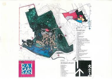
Document - Dai Gum San Concept Plans - Chinese Tourist Village Bendigo Victoria, 1980s
During the first goldrush of the 1850s, Chinese miners referred to the Bendigo region (then Sandhurst) as Dai Gum San 大金山 - literally 'Big Gold Mountain'. The Golden Dragon Museum is situated in the city of Bendigo, Victoria, Australia. The museum is dedicated to the culture and history of Chinese Australians, particularly in the region. Built on the historical site of one of Bendigo's Chinatowns, the museum's precinct also includes Chinese Gardens and a temple to Kuan Yin. Through the museum accreditation program, it was the first accredited museum in Victoria and opened in 1991. These plans are the original plans before the the Golden Dragon Museum was built on its current site.Dai Gum San Concept Plans - Chinese Tourist Village Bendigo Victoria - 4 Sheets in colour by Stephenson and Turner Victoria Architects and Planners Sheet 1 Concept Plan and Developed Site Plan Sheet 2 Arts and Crafts Buildings Sheet 3 Restaurant, Historical Museum and Temple Complex Sheet 4 Motelhistory, bendigo, eaglehawk, chinese, chinese museum, dai gum san -
 Bendigo Historical Society Inc.
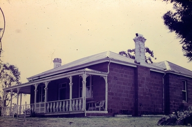
Slide - Adelaide Vale Homestead Fosterville
Adelaide Vale Homestead was begun in 1853 by John Harvey and was later occupied by Edward and Andrew O'Keefe. The building comprises a series of single storey stone buildings arranged behind a simple composed, verandah facade with a centrally located doorway flanked by windows. A central corridor leads from this doorway to a transverse corridor which was probably once an open breezeway. A free- standing octagonal pavilion is located close to the house. This is an interesting homestead dating from early times and constructed of local stone. The front facade is typically composed and the plan reflects the continuous growth of the property throughout the nineteenth century. The octagonal pavillion is a significant and unusual feature. The homestead is picturesquely sited and overlooks the Campaspe River valley, the Burke and Wills expedition camped nearby on their ill-fated expedition north. The old cheese factory is the sole survivor of the once extensive out-buildings. Some of the nineteenth century buildings have been demolished and there have been some later additions and alterations, notably an extensive side wing added in the 1920's. [In Butcher & Flanders, Bendigo Historic Buildings, 1987, the date of the house is given as 1868. Presumably this house replaced an older one on the property.]Adelaide Vale Homestead Fostervillehistory, bendigo, national trust collection bendigo, adelaide vale homestead -
 Bendigo Historical Society Inc.
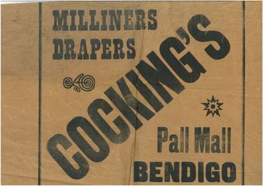
Work on paper - Three samples of wrapping paper (a-Cockings, b-Bennetts Store & c-Beehive stores)
Robert Samuel Valentine Cocking (1882 - 14/5/1945) Born in Bendigo, Val Cocking began hi retail career at Myer Bendigo before opening his own draper shop c. 1912 in the lower block Pall Mall. In 1914 he moved his stock into temporary premises while he renovated his new shop, which combined the former Post Office Hotel and adjacent grocery and stationary shops. The new emporium opened in Aug 1918 selling drapery and soft goods. Mr Cocking was a champion rifle shooter; President of the Bendigo Chamber of Commerce; President of the Sandhurst Football Club for 18 years and President of the Bendigo Cricket Club. Bennetts Hardware shop was in Hargeaves St near the entrance to Allan's Walk in the 1950's. Beehive buildings. This was originally the Sandhust Mining Exchange and as such was the oldest purpose built exchange in Australia and was one of only two in regional Australia. It was initially established in the 1850's to service the miners of the area. It's first double story incarnation as the Bendigo Stock Exchange, contained up to 2000 stockbrokers and 5000 shareholders. In 1871 the building burnt to the ground and the new and current building was completed in 1872. The modern building was designed by Charles Webb, who was also responsible for the Royal Arcade in Melbourne. and features a pitched glass roof similar to the Royal Arcade, Melbourne.Three samples of wrapping paper from a. Cockings, b. Bennetts Store & c. Beehive storeswrapping paper, cockings, bennetts, beehive -
 Bendigo Historical Society Inc.
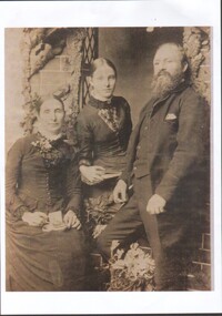
Photograph - Bedson family (father Samuel, wife Elizabeth & daughter Maude)
Samuel Bedson (1834 - 6/12/1909) Samuel Bedson worked at the Bendigo Pottery making artificial flowers for 20 years. He left Victoria in 1895 before dying in Christchurch, New Zealand. His daughter Maude married Horatio David Collier in 1894 and remained in Bendigo. Horatio founded Collier Shoes in the early 1900's. 8555 Bedson family (father Samuel, wife Elizabeth & daughter Maude). Samuel Bedson (1834 - 1909), wife Elizabeth (Nee Astbury) and daughter Maude Eliza (1873 - 1960) Samuel & wife came to Bendigo, either with or shortly after Geo. Guthrie; to open and work the Bendigo Pottery. Maude Eliza married Horatio David Collier. Marion Heeps grandparents. bedson family, bendigo -
 Bendigo Historical Society Inc.
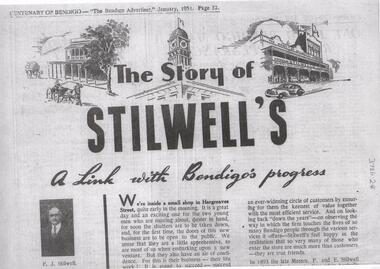
Document - The Story of Stilwell's, Bendigo Advertiser, January 1951, 9/11/23
Brothers Frederick and Ernest Stillwell opened a hardware and general ironmongery in Hargreaves St Bendigo in 1895. They were later joined by Roy Stillwell. The shop further developed and advertised as selling furniture, home furnishings and HardwareA 1951 Bendigo Advertiser story on the history of the Stilwell building on the 100th centenary of the city of Bendigo.stilwell, centenary, 1951 -
 Bendigo Historical Society Inc.
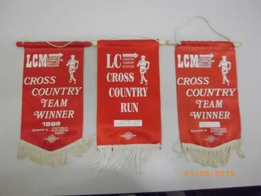
Banner - GOLDEN SQUARE P.S. LAUREL ST. 1189 COLLECTION: SPORTS FLAGS
Collection of sporting flags: 11 Loddon, Campaspe Mallee cross country; Team Winner 1989, red, 11 year old girls 2005, Team Winner Year Unknown; 8 years boys open 1995, 10 years girls 1995, Laurel street; 12/13 years boys 2003, 8 years old girls 2005, 9 years old boys, 12/13year boys 2000, 12/13 year girls 2000; 1Primary Schools basketball championship runners up 1996, 2 cricket team finalists, 1981-82, 1982-83; Team names provided; 3 BTCRSA Oakley winner flags, 1964, 1967 and 1969; Victorian Primary Schools' Sports Assn. Girls, Region runners up 1996.education, primary, golden square laurel st p.s. -
 Bendigo Historical Society Inc.
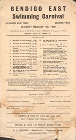
Document - BERT GRAHAM COLLECTION: BENDIGO EAST SWIMMING CLUB CARNIVAL, 10 February 1968
Document, Bert Graham Collection, Bendigo East Swimming Club Carnival, Bendigo East Pool, Eastern Park, Saturday February 10th, 1968. To be opened by His Worship the Mayor of Bendigo (Cr. W. Cambridge) at 3 o'clock. Admission, Adults, 25c, Children 10c. First Event 2.15 p.m. 18 events. Devonshire Afternoon Tea, sold on ground as well as, sweets, ice cream, soft drinks.bendigo, clubs, bendigo east swimming carnival -
 Bendigo Historical Society Inc.
Document - BERT GRAHAM COLLECTION: BENDIGO EAST SWIMMING CLUB, 15 December 1962
Document, Bert Graham Collection, Bendigo East Swimming Club, Official Opening of New Pool, 15th December 1962, at 2.15 pm.New Pool to be Officially Opened by Mr. J.P.Tully at 3pm.bendigo, sporting clubs, bendigo east swimming club -
 Bendigo Historical Society Inc.
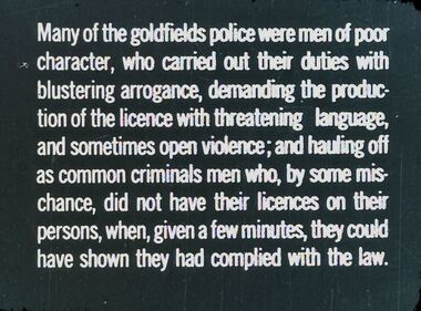
Slide - DIGGERS & MINING. THE GOLD LICENCE, 1850s
Diggers & Mining. The gold licence. The Government Camp. Many of the goldfields police were men of poor character, who carried out their duties with blustering arrogance, demanding the production of the licence with threatening language, and sometimes open violence; and hauling off as common criminals men who, by some mischance, did not have their licences on their persons, when, given a few minutes, they could have shown they had complied with the law. Markings: 35 994.LIF. 4. Used as a teaching aid.hanimounteducation, tertiary, goldfields -
 Bendigo Historical Society Inc.
Map - PETER ELLIS COLLECTION: MAP
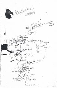
Five photocopies of drawings of the Rushworth area and three copies of Rushworth-Whroo. All maps have various features and some plants noted. Also mentioned is the Balaclava Hill Open Cut Mine.map, victoria, rushworth/whroo, peter ellis collection, rushworth, whroo, aboriginal water holes, balaclava hill open cut mine -
 Bendigo Historical Society Inc.
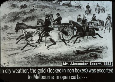
Slide - DIGGERS & MINING. THE GOLD LICENCE, c1852
Diggers & Mining. The gold licence. The Government Camp. Mt Alexander Escort, 1852. In dry weather, the gold (locked in iron boxes) was escorted to Melbourne in open carts. Markings: 22 994.LIF. 4. Used as a teaching aid.hanimounteducation, tertiary, goldfields -
 Bendigo Historical Society Inc.
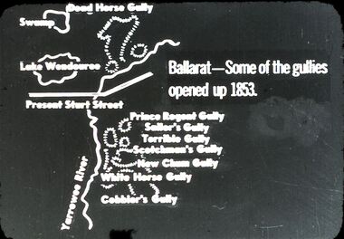
Slide - DIGGERS & MINING: THE DIGGINGS - THE DIGGERS
Diggers & Mining: The Digging - The Diggers. Slide depicting some land marks and mining sites in Ballarat opened up 1853. Markings: 11 994.LIF:6. Used as a teaching aid.hanimounteducation, tertiary, goldfields -
 Bendigo Historical Society Inc.
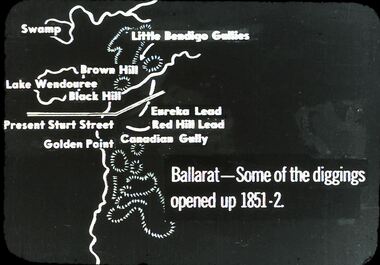
Slide - DIGGERS & MINING: THE DIGGINGS - THE DIGGERS
Diggers & Mining: The Digging - The Diggers. Slide depicting landmarks and mining sites in Ballarat. Some of the diggings opened up 1851-2. Markings:10 994.LIF:6. Used as a teaching aid.hanimounteducation, tertiary, goldfields -
 Bendigo Historical Society Inc.
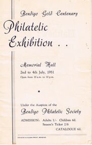
Document - RANDALL COLLECTION: BENDIGO GOLD CENTENARY PHILATELIC EXHIBITION, 2 July 1951
Event, Bendigo Gold Centenary Philatelic Exhibition, Memorial Hall, 2nd to 4th July, 1951, open from 10a.m. to 10p.m. Under the Auspices of the Bendigo Philatelic Society, Admission: Adults 1/-, Children 6d, Season's Ticket 2/6, Catalogue 6d.. Booklet contains 8 pages.Hocking & Sloan Print, Bendigo.event, philatelic exhibition -
 Bayside Gallery - Bayside City Council Art & Heritage Collection
Map - print, Melbourne and Metropolitan Board of Works, Interim development order: Brighton, Moorabbin and Sandringham, 1959
The Melbourne and Metropolitan Board of Works (now Melbourne Water) was established in 1891. From that time, as part of their work laying water and sewerage connections, they created detailed plans of houses and other buildings in the Melbourne metropolitan area. In 1956 it acquired powers to construct and maintain highways and bridges, protect and improve the foreshores and create and maintain parks within the metropolitan region. This Interim development order comprises part of the municipalities of Brighton, Moorabbin and Sandringham and was made on 20 October 1959.brighton, moorabbin, sandringham, melbourne and metropolitan board of works, map, town planning, cartographic material, interim development order, bayside -
 Bendigo Historical Society Inc.
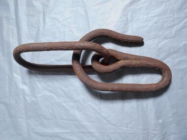
Functional object - Bucket hooks
Two bucket hooks made of metal used in mine shafts, one is a swivel hook that will open and close to lock on the bucket on to it. The other is an open hook that is attached to a chain. a; hook in closed position so the bucket can't come out. b; hook in open position to put the bucket on to the hook c; hook attached to a chain bucket hooks, minning -
Bendigo Historical Society Inc.
Booklet - Official Opening of the Greater Bendigo Indoor Swimming Complex
4-page booklet (A4 size paper folded in half). Official Opening of the City of Greater Bendigo Indoor Swimming Complex at Eaglehawk. Opened by the Minister for Sport, Recreation and Racing, the Hon. Tom Reynolds M.P. 2.30 pm Wednesday 14th December. Year not given but is in the 1990s Coloured photo of complex on front gage and page 3. Description of facilities, development, programmes and activities. eaglehawk swimming complex, peter krenz -
 Bendigo Historical Society Inc.
Administrative record - Axedale Waterworks Trust
Water scheme trust was created by the Governor in Council, 23/1/1963 and consisted of 3 Councilors of the Axedale Riding of the Shire of Strathfieldsaye and 3 members appointed by the Minister of Water Supply. The waterworks opened in April 1964Exercise book from the Axedale Waterworks Trust containing list of names and amounts of money due. Several receipts are either stapled to the book or loose inside issued to the trust by various businesses: Modern supplies, D. Smyth and son, Hardware Co. of Australia, Country Roads Bendigo J.G. Hibberd. Several other loose handwritten pieces of paper are inside, mostly recording payments or money dues also, two water reading slips, a notice of extraordinary meeting and an estimated receipts and expenditure for the year ending 31st December 1966. A newspaper article with photo of Mr. John Giovanetti, secretary of Bendigo Sewerage Authority is also included. The book covers the years from 1963 to 1966. Part of the Aileen and John Ellison. axedale waterworks trust, accounts, receipts -
Bendigo Historical Society Inc.
Booklet - Victoria Hill
Victoria Hill, accessed from Marong Road, was one of the richest areas on the Bendigo goldfields and was the beginning of reef mining as opposed to alluvial mining. Between 1853 and 1861 there were 16 claims registered on Victoria Hill. Between 1908 and 1910 it was the site of the world's deepest shaft (1365-1406 meters)Today it provides interpretive walks that include sites such as an open-cut mine (1850's), poppet head, quartz crushing battery (1930's) and the foundations of George Lancell's 180 mine. It is registered as a site of historical significance.Clear plastic cover spiral bound booklet of 25 pages. 'Victoria Hill'. A historical background of Victoria Hill and the surrounding area. A colour photo of a poppet head on front. Original story written by Albert Richardson in 1971. This is a revised edition by Philip Wilkin in 2012. Illustrated with colour and B&W photos. Pages 13 to 25 have been inadvertently inserted upside down. A single page A4 leaflet 'Victoria Hill Self Guided Tour' has been put inside after page 1Handwritten in ink on front page 'Donated to Specimen Cottage'victoria hill, gold mine