Showing 25607 items matching "plenty-township-estate"
-
 City of Moorabbin Historical Society (Operating the Box Cottage Museum)
Plan - Scott's Estate, Bentleigh
The train line from the city to Frankston was electrified in 1922 which intensified the sale in the municipality of Moorabbin, particularly land which was in the vicinity of the railway stations.Example of the progress of the Municipality of MoorabbinHand drawn plan of Scott's Estate, BentleighHand drawn plan of Scott's Estate, Bentleighcentre road, scotts street, renown street, lawaon street, wood street, leckie street, bolinda street, bentleigh, real estate -
 Eltham District Historical Society Inc
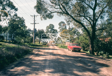
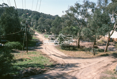
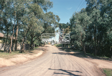
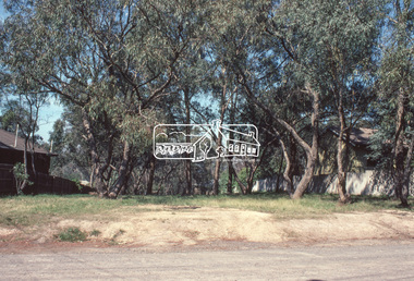
Slide, Quinn Estate, Sackville Street, Montmorency, 15 Sep. 1982
One of a series of images of roads and infrastructure taken by Eltham Shire Council Planning and Engineering officers of the Quinn Estate in Montmorency, Stage 1, Private Street Scheme during construction, September 1982. They provide perspective of the changes in housing styles and road development that began sweeping in from the mid 1970s with increasing urbanisation of what was once more outlying suburbs and regions.35 mm colour positive transparency (1 of15) Mount - Kodak Kodachrome CardProcessed 15 Sep1980housing estate, infrastructure, montmorency, quinn estate, roads, sackville street, private street scheme -
 Eltham District Historical Society Inc
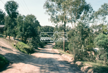
Slide, Quinn Estate, Quinn Way, Montmorency, 15 Sep. 1982
One of a series of images of roads and infrastructure taken by Eltham Shire Council Planning and Engineering officers of the Quinn Estate in Montmorency, Stage 1, Private Street Scheme during construction, September 1982. They provide perspective of the changes in housing styles and road development that began sweeping in from the mid 1970s with increasing urbanisation of what was once more outlying suburbs and regions.35 mm colour positive transparency (1 of15) Mount - Kodak Kodachrome CardProcessed 15 Sep1980housing estate, infrastructure, montmorency, quinn estate, roads, sackville street, private street scheme, quinn way -
 Eltham District Historical Society Inc
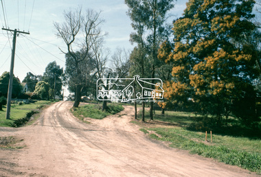
Slide, Quinn Estate, Cressy Street, Montmorency, 15 Sep. 1982
One of a series of images of roads and infrastructure taken by Eltham Shire Council Planning and Engineering officers of the Quinn Estate in Montmorency, Stage 1, Private Street Scheme during construction, September 1982. They provide perspective of the changes in housing styles and road development that began sweeping in from the mid 1970s with increasing urbanisation of what was once more outlying suburbs and regions.35 mm colour positive transparency (1 of15) Mount - Kodak Kodachrome CardProcessed 15 Sep1980housing estate, infrastructure, montmorency, quinn estate, roads, private street scheme, cressy street, nicholas lauder real estate -
 Eltham District Historical Society Inc
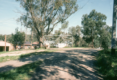
Slide, Quinn Estate, Reichelt Avenue, Montmorency, 15 Sep. 1982
One of a series of images of roads and infrastructure taken by Eltham Shire Council Planning and Engineering officers of the Quinn Estate in Montmorency, Stage 1, Private Street Scheme during construction, September 1982. They provide perspective of the changes in housing styles and road development that began sweeping in from the mid 1970s with increasing urbanisation of what was once more outlying suburbs and regions.35 mm colour positive transparency (1 of15) Mount - Kodak Kodachrome CardProcessed 15 Sep1980housing estate, infrastructure, montmorency, quinn estate, roads, private street scheme, mccarthy grove, reichelt avenue -
 Eltham District Historical Society Inc
Slide, Quinn Estate, Reichelt Avenue, Montmorency, 15 Sep. 1982
One of a series of images of roads and infrastructure taken by Eltham Shire Council Planning and Engineering officers of the Quinn Estate in Montmorency, Stage 1, Private Street Scheme during construction, September 1982. They provide perspective of the changes in housing styles and road development that began sweeping in from the mid 1970s with increasing urbanisation of what was once more outlying suburbs and regions.35 mm colour positive transparency (1 of15) Mount - Kodak Kodachrome CardProcessed 15 Sep1980housing estate, infrastructure, montmorency, quinn estate, roads, private street scheme, reichelt avenue -
 Eltham District Historical Society Inc
Slide, Quinn Estate, Buena Vista Drive, Montmorency, 15 Sep. 1982
One of a series of images of roads and infrastructure taken by Eltham Shire Council Planning and Engineering officers of the Quinn Estate in Montmorency, Stage 1, Private Street Scheme during construction, September 1982. They provide perspective of the changes in housing styles and road development that began sweeping in from the mid 1970s with increasing urbanisation of what was once more outlying suburbs and regions.35 mm colour positive transparency (1 of15) Mount - Kodak Kodachrome CardProcessed 15 Sep1980housing estate, infrastructure, montmorency, quinn estate, roads, private street scheme, buena vista drive -
 Eltham District Historical Society Inc
Slide, Quinn Estate, Reichelt Avenue, Montmorency, 15 Sep. 1982
One of a series of images of roads and infrastructure taken by Eltham Shire Council Planning and Engineering officers of the Quinn Estate in Montmorency, Stage 1, Private Street Scheme during construction, September 1982. They provide perspective of the changes in housing styles and road development that began sweeping in from the mid 1970s with increasing urbanisation of what was once more outlying suburbs and regions.35 mm colour positive transparency (1 of15) Mount - Kodak Kodachrome CardProcessed 15 Sep1980housing estate, infrastructure, montmorency, quinn estate, roads, private street scheme, footpaths and gutters, reichelt avenue -
 Eltham District Historical Society Inc
Slide, Quinn Estate, Reichelt Avenue, Montmorency, 15 Sep. 1982
One of a series of images of roads and infrastructure taken by Eltham Shire Council Planning and Engineering officers of the Quinn Estate in Montmorency, Stage 1, Private Street Scheme during construction, September 1982. They provide perspective of the changes in housing styles and road development that began sweeping in from the mid 1970s with increasing urbanisation of what was once more outlying suburbs and regions.35 mm colour positive transparency (1 of15) Mount - Kodak Kodachrome CardProcessed 15 Sep1980housing estate, infrastructure, montmorency, quinn estate, roads, private street scheme, reichelt avenue -
 Eltham District Historical Society Inc
Slide, Quinn Estate, McCarthy Grove, Montmorency, 15 Sep. 1982
One of a series of images of roads and infrastructure taken by Eltham Shire Council Planning and Engineering officers of the Quinn Estate in Montmorency, Stage 1, Private Street Scheme during construction, September 1982. They provide perspective of the changes in housing styles and road development that began sweeping in from the mid 1970s with increasing urbanisation of what was once more outlying suburbs and regions.35 mm colour positive transparency (1 of15) Mount - Kodak Kodachrome CardProcessed 15 Sep1980housing estate, infrastructure, montmorency, quinn estate, roads, private street scheme, mccarthy grove -
 Eltham District Historical Society Inc
Slide, Quinn Estate, Sackville Street, Montmorency, 15 Sep. 1982
One of a series of images of roads and infrastructure taken by Eltham Shire Council Planning and Engineering officers of the Quinn Estate in Montmorency, Stage 1, Private Street Scheme during construction, September 1982. They provide perspective of the changes in housing styles and road development that began sweeping in from the mid 1970s with increasing urbanisation of what was once more outlying suburbs and regions.35 mm colour positive transparency (1 of15) Mount - Kodak Kodachrome CardProcessed 15 Sep1980housing estate, infrastructure, montmorency, quinn estate, roads, private street scheme, sackville street, t-bowl -
 Eltham District Historical Society Inc
Slide, Quinn Estate, Reichelt Avenue, Montmorency, 15 Sep. 1982
One of a series of images of roads and infrastructure taken by Eltham Shire Council Planning and Engineering officers of the Quinn Estate in Montmorency, Stage 1, Private Street Scheme during construction, September 1982. They provide perspective of the changes in housing styles and road development that began sweeping in from the mid 1970s with increasing urbanisation of what was once more outlying suburbs and regions.35 mm colour positive transparency (1 of15) Mount - Kodak Kodachrome CardProcessed 15 Sep1980housing estate, infrastructure, montmorency, quinn estate, roads, private street scheme, reichelt avenue -
 Eltham District Historical Society Inc
Slide, Quinn Estate, Reichelt Avenue, Montmorency, 15 Sep. 1982
One of a series of images of roads and infrastructure taken by Eltham Shire Council Planning and Engineering officers of the Quinn Estate in Montmorency, Stage 1, Private Street Scheme during construction, September 1982. They provide perspective of the changes in housing styles and road development that began sweeping in from the mid 1970s with increasing urbanisation of what was once more outlying suburbs and regions.35 mm colour positive transparency (1 of15) Mount - Kodak Kodachrome CardProcessed 15 Sep1980housing estate, infrastructure, montmorency, quinn estate, roads, private street scheme, reichelt avenue -
 Melbourne Tram Museum
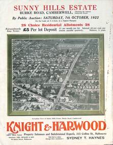
Ephemera - Real estate sale, Knight Harwood, "Sunny Hills Estate" - Burke Road Camberwell, Oct. 1922
Pamphlet advertising the sale of land at the "Sunny Hills Estate" Burke Road Camberwell 7-10-1922. Gives terms of sale, photos showing a nearby shopping centre, recently constructed houses, and plan of the subdivision. Land prices have been written in for each block on the pamphlet. Has a photo featuring Camberwell Junction with a tram, and Burke Road view with trams. Demonstrates the style of land sale pamphlet including the availability of tram services to prospective purchasers.Pamphlet - folded - printed in three colours of cream coloured paper with photographs and plans.has ink notes re sale price and notes.sale of land, trams, real estate, burke road, camberwell, sunny hills estate -
 Eltham District Historical Society Inc
Photograph - Digital Photograph, Alan King, Blue Lake, Plenty Gorge Park, 2008
A quarry was transformed into the Blue Lake. Published: Nillumbik Now and Then / Marguerite Marshall 2008; photographs Alan King with Marguerite Marshall.; p179 The dramatic steep-sided Plenty Gorge lies along the divide of two geological areas, and separates the Nillumbik Shire and the City of Whittlesea. On the Nillumbik side are undulating hills and sedimentary rock, and in Whittlesea, lies a basalt plain formed by volcanic action up to two million years ago. This provides the Plenty Gorge Park with diverse vegetation and habitats, making it one of Greater Melbourne’s most important refuges for threatened and significant species. The park, established in 1986, consists of around 1350 hectares, and extends 11 kilometres along the Plenty River, from Greensborough to Mernda. It provides a wildlife corridor for around 500 native plant and 280 animal species. The area’s plentiful food and water attracted the Wurundjeri Aboriginal people and then European settlers. By 1837 squatters had claimed large runs of land for their sheep and cattle. The Plenty Valley was among the first in the Port Phillip District to be settled - mainly in the less heavily timbered west - and was proclaimed a settled district in 1841.But by the late 1880s, the settlers’ extensive land clearing for animal grazing, then agriculture, depleted the Wurundjeri’s traditional food sources, which helped to drive them away. Many Wurundjeri artefacts remain (now government protected), and so far 57 sites have been identified in the park, including scarred trees, burial areas and stone artefacts. Pioneer life could be very hard because of isolation, flooding, bushfires and bushrangers. Following the Black Thursday bushfires of 1851, basalt was quarried to build more fire-resistant homes. Gold discoveries in the early 1850s swelled the population, particularly around Smugglers Gully; but food production made more of an impact. In the late 1850s wheat production supplanted grazing. In the 1860s the government made small holdings available to poorer settlers. These had the greatest effect on the district, particularly in Doreen and Yarrambat, where orchards were established from the 1880s to 1914. Links with a prominent early family are the remains of Stuchbery Farm, by the river’s edge bounded by Smugglers Gully to the north and La Trobe Road, Yarrambat, to the east. The Stuchberys moved to the valley in 1890, and the family still lives in the area. In 1890, Alfred and Ada first lived in a tent where four children were born, then Alfred built the house and outbuildings around 1896. They planted an orchard, then a market garden, and developed a dairy. The family belonged to the local Methodist and tennis communities. Their grandson Walter, opened the Flying Scotsman Model Railway Museum in Yarrambat, which his widow, Vi, continues to run. Wal was also the Yarrambat CFA Captain for 22 years until 1987. Walter sold 24 hectares in 1976 for development - now Vista Court - and in 1990, the remaining 22.6 hectares for the park. Remaining are an early stone dairy and remnants of a stone barn, a pig sty and a well. Until it was destroyed by fire in 2003, a slab hut stood on the Happy Hollow Farm site, at the southern end of the park. The hut is thought to have been built in the Depression around 1893. This was a rare and late example of a slab hut with a domestic orchard close to Melbourne. Emmet Watmough and his family first occupied the hut, followed by a succession of families, until the Bell family bought it around 1948. There they led a subsistence lifestyle for 50 years, despite encroaching Melbourne suburbia. The Yellow Gum Recreation Area includes the Blue Lake, coloured turquoise at certain times of the year. Following the 1957 bushfires, this area was quarried by Reid Quarries Pty Ltd for Melbourne’s first skyscrapers, then by Boral Australia. However in the early 1970s water began seeping into the quarry forming the Blue Lake and the quarry was closed. The State Government bought the site in 1997 and opened it as a park in 1999.This collection of almost 130 photos about places and people within the Shire of Nillumbik, an urban and rural municipality in Melbourne's north, contributes to an understanding of the history of the Shire. Published in 2008 immediately prior to the Black Saturday bushfires of February 7, 2009, it documents sites that were impacted, and in some cases destroyed by the fires. It includes photographs taken especially for the publication, creating a unique time capsule representing the Shire in the early 21st century. It remains the most recent comprehenesive publication devoted to the Shire's history connecting local residents to the past. nillumbik now and then (marshall-king) collection, blue lake, plenty gorge park -
 Ringwood and District Historical Society
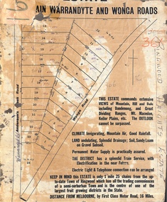
Map, Partially Trimmed Copy of Ringwood Heights Estate, Ringwood, Vic. - circa 1923
Clipped copy of a subdivision advertisement on cardboard backing. Sales notations on numbered allotments in Andersons's Creek Road (later Warrandyte Road) and Wonga Road, Ringwood. Handwritten title reference - LP7305. Captions - This Estate commands extensive views of mountain, hill and dale including Dandenong and Great Dividing Ranges, Mt. Macedon, Keilor Plains, etc. The outlook cannot be surpassed. Climate invigorating, mountain air, good rainfall. Land undulating, splendid drainage; soil, sandy loam on gravel subsoil. Permanent water supply is practically assured. The district has a splendid train service, with electrification in the near future. Electric light & telephone connection can be arranged. Keep in mind this estate is only 1 mile 25 chains from the up-to-date town of Ringwood which has all the trading conveniences of a semi-suburban town and is the centre of one of the largest fruit growing districts in the state. Distance from Melbourne by first class motor road, 16 miles. -
 Warrnambool and District Historical Society Inc.
Document - Ludeman Real Estate envelope, Early 21st century
This is an envelope used in the business of Ludeman Real Estate, Warrnambool. The Director, Bruce Ludeman, had previously been a stock and station agent before establishing his real estate business in Warrnambool in 1985. Bruce Ludeman, a business broker, auctioneer and property manager, is President of the Otway Division of the Real Estate Institute of Victoria and received a Presidents Award in 2012 for services to the real estate industry in the Western District. This envelope is of minor interest as an example of the type of business envelope used today in the real estate businesses in Warrnambool. This is a business-type white envelope with a see-through insert to show the address. It is self-sealing. The name and business address of Ludeman Real Estate is printed at the top left hand corner of the envelope. It also has a stamp to show that postage has been paid. ‘Ludeman Real Estate p/l 122 Liebig Street Warrnambool Victoria 3280’history of warrnambool, businesses in warrnambool, ludeman real estate, bruce ludeman, warrnambool history, liebig street -
 Clunes Museum
Photograph - LITHOGRAPH PRINT
THIS PHOTOGRAPH WOULD HAVE BEEN TAKEN PRIOR TO THE FIRESWHICH DESTROYED THE ORIGINAL SHOPS IN FRASER STREETLITHOGRAPH OF A SCETCH OF PORT PHILIP MINING COMPANY AND THE TOWNSHIP OF CLUNES WITH FRASER STREET IN THE FRONT ORIGINAL PHOTOGRAPH TAKEN FROM THE HILL BEHIND THE OLD LIBRARY IN TEMPLETON STREET TOWNSHIP OF CLUNES 1869 HANDSIGNED BY GEOFFREY BLAINEY - 17/3/2001clunes 1869 port philipmine, geoffrey blainey, lithograph of mine -
 City of Moorabbin Historical Society (Operating the Box Cottage Museum)
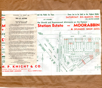
Flyer - Moorabbin Electric Station Estate, Moorabbin, 1941
The train line from the city to Frankston was electrified in 1922 which intensified the sale in the municipality of Moorabbin, particularly land which was in the vicinity of the railway stations. Moorabbin Electric Station Estate Sale of unsold and repossessed Allotments, the original sale was on Saturday 30 May 1925.Example of the progress of the Municipality of MoorabbinAdvertising flyer for auction of real estate sales - plan of building blocks for saleMoorabbin Electric Station Estate, Moorabbin. Auction Saturday 8 March 1941 - 9 villa units 4 shop sitessouth road, station street, taylor street, healey street, jasper street (now redholme street), central avenue, moorabbin, real estate -
 Melbourne Tram Museum
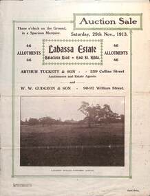
Ephemera - Real estate sale, Arthur Tucett & Son, "Labassa Estate" - Balaclava Road, East St Kilda, Nov. 1913
Pamphlet advertising the sale of land at the Labassa Estate, Balaclava Road 29-11-1913. Promotes the tram service, St Kilda Esplanade with a photo of PMTT 15 at the entry to Labassa at the corner of Orrong Road and Balaclava Road. Has a plan for the sub-division in to 46 allotments, terms of sale, and restrictions of what could be built on the land. The original Labassia Mansion is now owned by the National Trust.Demonstrates the style of land sale pamphlet including the availability of tram services to prospective purchasers.Pamphlet - folded - printed in two colours of cream coloured paper with photographs and plans.sale of land, trams, balaclava, balaclava road, real estate, labassa, orrong road -
 Melbourne Tram Museum
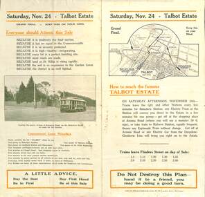
Ephemera - Real estate sale, Forrester & Co, "Talbot Estate" Balaclava, Nov. 1917
Pamphlet advertising the sale of land at the Talbot Estate on the south side of Balaclava Road, Balaclava on Saturday 24 Nov. 1917. Promotes the train service from Flinders St, tram service, St Kilda Esplanade, tram services including a photo of PMTT No. 61 at the intersection of Kooyong Road and Balaclava Road. Gives details of the tram fares, agents, solicitors, terms of sale, roads and water supplies.Demonstrates the style of land sale pamphlet including the availability of tram services to prospective purchasers.Pamphlet - folded - printed in two colours of cream coloured paper with photographs.sale of land, trams, balaclava, balaclava road, real estate, talbot estate -
 Ringwood and District Historical Society
Article - Newspaper Clipping, Land Sale Advertisements, Golden Hill Estate, Ringwood - 1965, 1966, and Plan of Survey of Lot 8, Mullum Mullum Road Ringwood, 1970
Newspaper clippings from Melbourne Sun newspaper (11th December 1965 and 15th January 1966) advertising sale of land - Golden Hill Estate, Ringwood, with summary of features and aerial photograph including artistic representation of street layout. Subdivision includes Mullum Mullum Road, Sonia Street, Jill Court, Linda Drive, Eve Court, Alma Court, and Jacynthe Court. Attachments include reference to Lot 46 as site of original Peter Vergers' orchard residence and subsequent 1970 surveyor's Plan of Survey of Lot 8 Mullum Mullum Road Ringwood, LP 67513, Cert of Title 8581/429.Agent - Aaron, King & Co., Suite 2, 33 Queens Road, Melbourne. (Phone) 26-2443, A.H. 850-2195. Plan of Survey signed on 25.7.1970 by Roger M. Gamble, Land Surveyor, 28 Summit Crescent, Ringwood 3134. -
 Kew Historical Society Inc
Plan - Subdivision Plan, Mayfield Estate, 1927
A number of the plans in the Kew Historical Society’s collection can also be found in other collections, such as those of the State Library of Victoria. A number are however unique to the collection.The Kew Historical Society collection includes almost 100 subdivision plans pertaining to suburbs of the City of Melbourne. Most of these are of Kew, Kew East or Studley Park, although a smaller number are plans of Camberwell, Deepdene, Balwyn and Hawthorn. It is believed that the majority of the plans were gifted to the Society by persons connected with the real estate firm - J. R. Mathers and McMillan, 136 Cotham Road, Kew. The Plans in the collection are rarely in pristine form, being working plans on which the agent would write notes and record lots sold and the prices of these. The subdivision plans are historically significant examples of the growth of urban Melbourne from the beginning of the 20th Century up until the 1980s. A number of the plans are double-sided and often include a photograph on the reverse. A number of the latter are by noted photographers such as J.E. Barnes.The Mayfield Estate subdivision included 14 allotments surrounding Evan Court (now Evans Court) in Toorak. The subdivision adjoined Toorak Road east of Kooyong Road and alerted prospective buyers to how the Toorak Road tram would take them directly to the city. This emphasis on existing transport routes was a feature of subdivisions during a period when car ownership was the preserve of the wealthy. An existing brick villa (‘Mayfield’) is noted as already constructed on lot 13. The subdivision also notes that the lots adjoin land owned by Sir Edward Miller. Today Evans Court extends beyond this subdivision through to Moonga Road.subdivision plans - toorak, mayfield estate, sir edward miller -
 Ringwood and District Historical Society
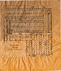
Map, Allotments - Township of Ringwood - Parish of Ringwood - County of Mornington - 1886, 1886
[Page 3, Horse Shoes to High Heels - Richard Carter] ... "(In the year 1882) the railway was extended from Hawthorn through Ringwood to Lilydale and later to Ferntree Gully." Linen-backed map of Ringwood area lithographed at the Department of Lands and Survey, Melbourne, 5th November, 1886.old lilydale road, new lilydale road, victoria brick and tile co., ringwood brick co., federal brick co. -
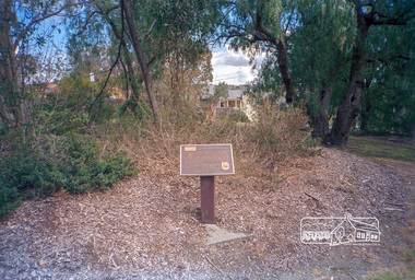 Eltham District Historical Society Inc
Photograph, Monument containing a time capsule in celebration of Victoria's 150th Anniversary and marking the location of the original centre of Eltham township, c. October 1990, 1990
Roll of 35mm colour negative film, 4 stripsKodak GC400-8monuments, plaques, time capsule -
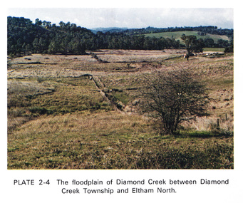 Eltham District Historical Society Inc
Work on paper (Sub-Item) - Photograph, The floodplain of Diamond Creek between Diamond Creek township and Eltham North
floodplain, eltham north -
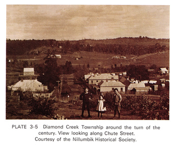 Eltham District Historical Society Inc
Work on paper (Sub-Item) - Photograph, View along Chute Street, Diamond Creek township, about 1901
diamond creek, chute street, view, nillumbik historical society