Showing 10524 items
matching land
-
 Kew Historical Society Inc
Photograph - Flooding of the Yarra Valley at Kew East, 1974
Flooding of the Yarra Valley, including that section of the Yarra bordering Kew and Kew East in the north and west of the municipality, was a regular occurrence. Extreme flood events of the Yarra River are recorded to have occurred in 1891, 1901, 1916, 1923 and 1934. The Municipality of Kew's response to these floods was to enact planning decisions restricting residential development in flood prone areas following the floods of 1916, 1921 and 1934. While floods continued after the development of the Upper Yarra Reservoir (construction 1948-57), the regularity and extent of these inundations diminished. During the nineteenth century, the land abutting the south side of the Yarra in Kew was devoted to dairy farming. In the twentieth century, before and after the construction of the Eastern Freeway, much of this low-lying area was used as golf courses and public parks.Late example of the capacity of the Yarra Valley at Kew to flood, even though drainage works and the Upper Yarra Reservoir had reduced their regularity.Original black and white print photograph of the low-lying land at East Kew under floodwater on 16 May 1974. The vantage point of the photographer is Lister Street. Flooding was caused by overflowing water in Glass' Creek and the River Yarra. Annotation verso: "Lister St looking same as No.3 / 16 May 1974 11.30"floods, yarra river, glass' creek, lister street -
 Federation University Historical Collection
Plan, Burrumbeep, 1884, 16/10/1884
Auctions of Crown land were introduced in the Colony of Victoria from 1851 to encourage settlers to occupy and work the land. Many squatters purchased land at auction at the upset (minimum) price of £1 per acre. In some areas where demand was high, such as the goldfields, the price realised at auction was much more. Land was put up for sale in the study area on the Burrumbeep run in May 1855, on the Lexington run in 1857, and on the Gorrinn run in 1858. (http://www.ararat.vic.gov.au/library/document/thermatics.pdf, accessed 27 January 2015) For 70 years or more, Yalla-y-Poora, Burrumbeep, Edgarley, Mount William and Narrapumelap ranked in the leading wool producers in Victoria. 1 Stud owners at Yalla-y-Poora, Eurambeen, Burrumbeep and Challicum crossed merino sheep with sheep descended from John Macarthur's Camden Park in New South Wales. (http://www.ararat.vic.gov.au/library/document/thermatics.pdf, accessed 27 January 2015) In what was to become the Ararat Mining Division, gold was discovered in May 1854 on the Burrumbeep run at a place that became known as Pinky Point on the Mount William goldfield. By 21 June 1854, between 600 and 1,000 people had arrived. (http://www.ararat.vic.gov.au/library/document/thermatics.pdf, accessed 27 January 2015)\ Town allotment plan for Burrumbeep. Merrymbuela, Borung, Lexington and Langi Logan are neighbouring areas. The plan includes the Burrumbeep Pre-Emptive Right (Roger and Wright); licensed land holders including Stephen Young, John Carroll, William Walsh, Thomas Purcell, Martha M. Bond, Colin Johnson, John Charles Webb, Henry Withycombe, William Henry Barbridge, John Wall, Thomas Flatelly, William Jenkinson, Elisia Radford, V. Radford, Denis Byrne, George Cook. Land holders included Andrew Maloney, Richard Wingfield Harrocks, W. Sporton, Terence Lynch, F. S. Falkiner, A. Millman, H. Morris, George Upham, J. McCLure, S. Fletcher, W. Parker, Thomas Myers, William wright, W.C. Winter, C. Wordman, Oliver A. Winter This plan is associated with former Ballarat School of Mines student Richard Squire (1875-6) Gift of the Squire FamilyVerso written in pencil - Plan of Burrembeep Ararat Burrembeep Araratburrumbeep, corrinn, langi logan, merrymbuela, lexington, ararat, roger & wright, cook, rogers, upham, george upham, ross, parsans, morris, johnson, withycoombe, colin johnson, falkiner, dsporton, john carroll, donald gordon, denis bryne, maurice dooley, martha bond, william harricks, \william wingfield harricks, william l.c. harricks, michael houlihan, thomas purcell, martin ryan, michael cody, fletcher, mccaw, w. parker, j.m. clow, elisia radford, thomas radford, thomas myers, barbridge, e. wilde, j. wall, flatelly, g. wardman, w.c. winter, david ball, jenkinson, ballarat school of mines, richard squire, squire -
 Ringwood and District Historical Society
Document - Department of Lands and Survey, Wire Netting Branch, Melbourne, Victoria, Application for Vermin-Proof Fence Certificate - L.J. Mills vs John Collins, Grandview Grove, Ringwood, Victoria - 1939
Photocopied file of corresponence and documentation relating to a claim by L.J. Mills, Nurseryman, that adjoining property owner, J. Collins, Farmer, assists with replacement of a vermin proof wire netting dividing fence destroyed by 1939 bushfire. File includes 1939 and 1940 detailed property inspection reports by Vermin and Noxious Weeds Branch, Lands Department, Lilydale, describing land use in the area and signs of vermin activity. Application approved 18th April, 1940. Appeal lodged by Mr Collins disallowed in May, 1940. File closed June, 1940 with Departmental suggesion that Mr Mills consider further legal action through a Solicitor as fence had still not been wire-netted. TRANSCRIPTS: Vermin & Noxious Weeds Inspection Reports "19/9/1939 (To) Superintendent (Department of Lands and Survey, Melbourne) Re L.J. Mills application for Vermin Proof Fence. I called on Mr Mills yesterday 18th instant in connection with this matter. Mr Mills has a flower farm and claims that rabbits and hares are damaging his flowers. He showed me a bed of carnations which he stated were being damaged by rabbits. There was evidence of some leaves being nipped off, but I am unable to say whether this is due to rabbits or grubs. Very little if any real damage is being done. The property is netted on the east and south boundary and on half the north and west boundary. The surrounding country is undlating and fairly steep in places. The land to the east across Grandview Avenue (sic) is all planted out in old established orchards and well cultivated. Cleared grass land adjoins the south boundary and bush land adjoins the north and west boundaries. I walked over a large area surrounding Mr Mills land and never saw any rabbits or hares or any indications of rabbits. This locality is not rabbit infested and very little wire netting is being used. I do not consider that a vermin proof fence is necessary between these allotments. - Jas H Allison (Inspector, Vermin and Noxious Weeds Branch, Lands Department, Lilydale)." Follow up report following renewal of application for Certificate by Mr Mills, citing rabbits causing considerable damage to his flowers. He laid poison and obtained 9 carcases and stated that there is evidence of rabbit infestation from the adjoing land. "19/3/1940 (To) Mr Hannah (Superintendant, Department of Lands and Survey, Melbourne) Re L.J. Mills, Grandview Grove Ringwood, Lot 4 Grandview Estate Pt CG20 Ph of Warrandyte. I interviewed Mr Mills at his home on 15th inst. He showed me carcases of rabbits which he stated had been poisoned on his land. In places young plants had been nipped off apparently by rabbits. I made an inspection of adjoining properties and found one live burrow close to Mr Mills northern boundary. There were scratches and other evidence of rabbits on land north and west of Mr Mills property. In view of the present evidence of rabbits I consider that a vermin proof fence is now necessary to protect the flowers grown by Mr Mills. His land is netted on whole of east and south boundary and half way on west and north boundary. The adjoining land on west and north boundaries is owned by Mrs Linda Collins and John Collins resp of Brysons Road East Ringwood. - Jas H Allison (Inspector, Vermin and Noxious Weeds Branch, Lands Department, Lilydale)." -
 Marysville & District Historical Society
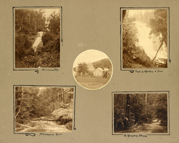
Photograph (item) - Black and white photographs, Unknown
An album page with five photographs of 5 natural attractions in an around Marysville in Victoria.An album page with five photographs of 5 natural attractions in an around Marysville in Victoria.Steavenson Falls 18/ Steavenson River 21/ "Land of mountain or flood" 20/ a Mountain Stream 22steavenson falls, steavenson river, marysville, victoria, waterfalls -
 Greensborough Historical Society
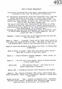
Article, Let's visit Bundoora, 1841o
This collection of notes aims 'for a deeper appreciation and understanding of the impact of our lives; culture and actions;.in Bundoora; a developing community'. Includes copies of uncited articles; photos and maps.Background information on Bundoora in the 20th century.Collection of articles, possibly notes from an oral presentation. Complete document available at GHS."Contents largely sourced from "In the beginning there was only the land", Len Kenna, 1988." - note on page 1.bundoora -
 Glenelg Shire Council Cultural Collection
Photograph - Photograph - Portland Harbour, Aug-89
Port of Portland Authority ArchivesBack: 'Land slip and infill Yacht Club / Henty Beach area August 89' black biroport of portland archives -
 Clunes Museum
Photograph, ROGER PURCELL, SEBASTAPOL GARDENS, 1994 [COPY]
ORIGINAL PHOTOGRAPH OWNED BY MR. WILLIAM HARRIS OF SUTHERLAND STREET CLUNES..1 ORIGINAL PHOTOGRAPH OF PEOPLE WORKING IN THE GARDEN ON THE OTHER SIDE OF THE CREEK.. THE PHOTOGRAPH IS GLUED ON TO LIGHT BROWN CARDBOARD .2 - .4 COPIES OF POINT 1 .5 A COPY OF THE ORIGINAL (.1) PHOTOGRAPH GLUED ONTO CREAM CARDBOARDW H HARRIS LAND CIRCA 1870 -1880 WINNERS OF PICKLES AND JAMS COMPETITION IN INDIA 1886 harris family, sebastapol gardens, w h harris, pickles and jams competition -
 National Wool Museum
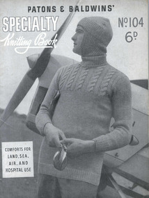
Book, Knitting, Patons and Baldwins' Specialty Knitting Book no. 104
This knitting pattern book was produced during 1939-45 by Patons and Baldwins' and contains knitting patterns for mens civilian and service garments. It also includes a number of patterns for convalescent and hospital coverings, including a splint coverKnitting Book (front cover) - Patons and Baldwins' Specialty Knitting Book no. 104, WWII. Knitting Book (back cover) - Patons and Baldwins' Specialty Knitting Book no. 104, WWII.PATONS & BALDWINS' / SPECIALTY / Knitting Book / No. 104 / 6D. / COMFORTS FOR / LAND, SEA, / AIR, AND / HOSPITAL USEknitting world war ii, patons and baldwins (australia) ltd, knitting, world war ii -
 Whittlesea Historical Society Inc.
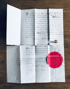
Document, Whittlesea Town Common, 1866
Document appointing Thomas Williamson to be the manager of the Whittlesea Town Common.Handwritten material on blue paper relating to the appointment of James Williamson to be one of the managersof the Whittlesea Town Common. The document has been folded and has torn along the fold lines. Handwritten document with signatures. Red paper seal of the Board of Land and Works. Dated 8th June 1866.thomas williamson, whittlesea town common, board of land and works -
 Ringwood and District Historical Society
Newspaper, Scrapbook Clipping, Library Collection, Ringwood, Victoria, `
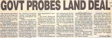
``Newspaper clipping from "The Post" 26-7-95, P 1. GOVT PROBES LAND DEAL The proposed multi-million dollar sale of the Ringwood Bowling Club site to retail giant Coles Myer, is currently being investigated by the State Government. Local Government minister, Roger Hallam, confirmed the Office of Local Government investigation this week.` -
 Bendigo Military Museum
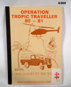
Administrative record - Operation Tropic Traveller 80 - 81 1 Field Survey Squadron, 1981
Project report, Operation Tropic Traveller 1980/81 was mounted to field complete the North Queensland Tac map area during the periods 25 Feb to 11 Nov 1980 and 3 Mar to 13 Oct 1981 Buff colored, A4 Folder, Mosaic in brown of Nth Qld, Helicopter, Corps badges, Land rover.1 field survey squadron, 1 fd svy sqn, royal australian survey corps -
 Phillip Island and District Historical Society Inc.
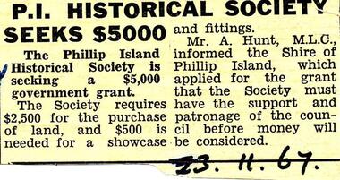
Newspaper clippings, 23/11/1967
Collection of newspaper clippers in scrap book dated 1960 - 1973Newspaper article concerning a financial grant being sought by the Phillip Island Historical Society for land and a showcase."P.I. Historical Society seeks $5,000"local history, newspapers, phillip island historical society seeking grant of $5000, jean jamieson -
Glenelg Shire Council Cultural Collection
Photograph - Photograph - Henty Beach, Aug-89
Port of Portland Authority ArchivesBack: 'Henty Beach area (Yacht club end) August 89 -
Glenelg Shire Council Cultural Collection
Photograph, Portland Wool Brokers Limited, Wool Store, n.d
Port of Portland AuthorityFront: (no inscriptions) Back: 177 (top left, pencil)port of portland -
Eltham District Historical Society Inc
Photograph, Top of the Devils Bank - Eltham, 1906c
Photograph from land sales brochure c1906 showing scene from top of the Devils Bank Elthamdevils bank, eltham -
 Federation University Historical Collection
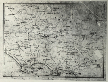
Photograph - Black and White, Map of Western Victoria
WGS 84 37" 47' S 142" 08' EPhotograph of a map showing the Grampians, Glenelg, Portland, Belfast (Port Fairy), Warrnambool, roads and land-holders.western victoria, victoria, belfast, port fairy, warrnambool, manifold -
Glenelg Shire Council Cultural Collection
Photograph - Photograph -Reclamation and Canal work, 1959
Port of Portland Authority ArchivesBack: November 1959 - Top right, black biro. Reclamation and canal work at southern end of botanic gardens - bottom left, pencil.port of portland archives, land reclamation, canal -
Glenelg Shire Council Cultural Collection
Photograph - Photograph - land reclamation, 1959
Port of Portland Authority ArchivesFront: Canal and Reclamation. Aerial view west November 1959 - typed.port of portland archives, land reclamation, canal, botanic gardens -
 Running Rabbits Military Museum operated by the Upwey Belgrave RSL Sub Branch
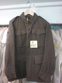
Tunic
TUNIC khaki army Wool with colour patches (RAA 1 Aust. Corps, Land H Q.)uniform, 1949, army -
 Bendigo Historical Society Inc.
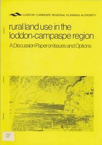
Book - RURAL LAND USE IN THE LODDON-CAMPASPE REGION, 1976
RURAL LAND USE IN THE LODDON-CAMPASPE REGION - a discussion paper on issues and options. 30 pages, with maps.Loddon-Campaspe regional planning authoritybook, rural, land use, loddon campaspe, rural, land use, agriculture -
 Bendigo Historical Society Inc.
Document - TED BEATTIE COLLECTION: INFORMATION SHEET, Pre 1980s
Information sheet 'Bendigo - where to go and what to see gold centre victoria - land of the welcome stranger' -
 Bendigo Historical Society Inc.
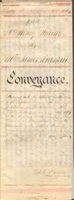
Document - JOHANSON COLLECTION: MORTGAGE MRS CATHERINE STUART RICHARDS
Conveyance of land from Mr Henry Smith to Mr. James Penistan. Dated 22 April 1864.bendigo, land sales, mr. henry smith to mr. james penistan, henry smith, james penistan. -
Bendigo Historical Society Inc.
Film - FROM THE LAND OF PASTIES AND CREAM, 2010
DVD. From the Land of Pasties and Cream. A Tribute to the Cornish Miners of Bendigo and Eaglehawk. A Documentary by Jamie Roberts. -
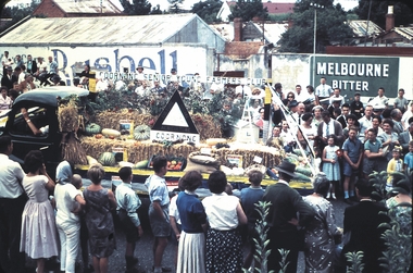 Bendigo Historical Society Inc.
Slide - BENDIGO EASTER PROCESSION, Apr 1961
Slide.BENDIGO EASTER PROCESSION. Goornong Senior Young Farmers Club float depicting produce grown on the land.slide, bendigo, bendigo easter procession, bendigo easter procession -
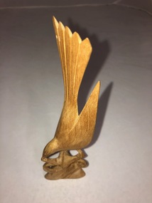 Dutch Australian Heritage Centre Victoria
Wooden Bird Carving
Small pale wooden carving of a bird about to land on a tree branch which forms the carving's base. -
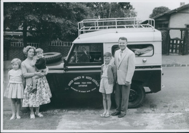 Uniting Church Archives - Synod of Victoria
Photograph, Thomas Verrier & family, 1962
Thomas Verrier (ordained 1961): Sprent (Tas.) (HM) 1956–60; Katherine (NT) 1962–65; Nightcliff (Darwin) 1966–67; Bendigo North 1968–71; Burnie (Tas.) 1971–76; Bayswater & Wantirna 1977–?.Thomas Verrier and family standing alongside the Land Rover ready to depart for Uranium Fields Patrol Katherine.Rev. Thomas Verrier and family before departure for Katherine.verrier, thomas -
Lakes Entrance Regional Historical Society (operating as Lakes Entrance History Centre & Museum)
Book, Delbridge Graham R, Freeman Anne, The Church of St Peters by the Lakes, 1976
History of St Peters by the Lakes Paynesville Victoria, acquisition of land, building plans, forward by Bishop Delbridgereligion -
Stawell Historical Society Inc
Photograph - Aerial Photograph, Norwellan / AUNDE
Textile Mill infrastructure when Norwellan North Western Woolen Mills became Norwellan Textiles then AUNDEEarly Colour Aerial Photograph showing complete land and infrastructure. Plastic frame imitating brown marble.industry -
Whitehorse Historical Society Inc.
Document, Certificate of title, 28/02/1924 12:00:00 AM
Certificate of Title for c. 3 acres of land east of Mitcham Road owned by Mary Theresa KirkpatrickCertificate of Title for c. 3 acres of land east of Mitcham Road owned by Mary Theresa KirkpatrickCertificate of Title for c. 3 acres of land east of Mitcham Road owned by Mary Theresa Kirkpatrickmitcham road, mitcham -
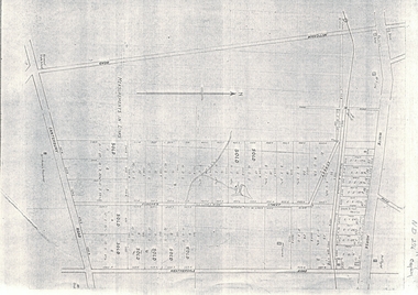 Whitehorse Historical Society Inc.
Document, Map of Vermont & Mitcham
Copy of map showing land in Mitcham and Vermont areasCopy of map showing land in Mitcham and Vermont areas bounded by Whitehorse , Mitcham, Canterbury and Heatherdale roads.Copy of map showing land in Mitcham and Vermont areasland subdivision, whitehorse road, mitcham, heatherdale road, canterbury road, vermont, mitcham road