Showing 3758 items
matching surveyed
-
 Bendigo Historical Society Inc.
Map - CAMPBELL COLLECTION: BENDIGO AND DISTRICT MAPS, August 1952
Map. Nerring, County of Bendigo, Yarraberb, Neilborough, Leichardt, Marong, Sandhurst, Huntly. Scale 20 chains to 1 inch. Drawn and reproduced at the Department of Lands and Survey, Melbourne, Victoria, August 1952. Price 2/-. By Authority J.J. Gourley, Government Printer, Melbourne. (number 404 in map cupboard 1)J.J. Gourley, Government Printermap, bendigo, allotments -
Bendigo Historical Society Inc.
Map - CAMPBELL COLLECTION: BENDIGO AND DISTRICT MAPS, 1963
Map. Sedgwick, County of Bendigo. Scale 20 chains to 1 inch. Strathfieldsaye, Eppalock, Lyell, Mandurang, Sutton Grange, County of Talbot. By Authority A.C. Brooks,Government Printer, Melbourne. Drawn and reproduced at the Department of Lands and Survey, Melbourne.1963. Price 2/-. (number 405 in map cupboard 1)A.C. Brooks, Governmenr Printer, Melbourne.map, bendigo, allotments -
Bendigo Historical Society Inc.
Map - POMPAPIEL : COUNTY OF BENDIGO, 1-10-27
Map. Pompapiel, County of Bendigo, Calivil, Janiember East, Yarrayne, Salisbury, Yallook, Talambe, Judyong Creek, Bullock Creek, Pompapiel Creek, Edeyrn Estate. Photo-Lithographed at the Department of Lands and Survey, Melbourne by W.J. Butson, 1-10-27, Price 1/-. (number 4 in map cupboard 1)W.J. Butson, Government Printermap, bendigo, pompapiel -
 Orbost & District Historical Society
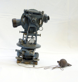
theodolite, first half 20th century
Theodolites have been used to measure horizontal and vertical angles by surveyors since the 1500s. A theodolite is a precision instrument for measuring angles in the horizontal and vertical planes. Theodolites are used mainly for surveying applications, and have been adapted for specialized purposes in fields like meteorology and rocket launch technology. Theodolites, such as this one, were instrumental to early surveyors, and would have played a significant part in their everyday work. The plumb bob was used to set the instrument exactly over a fixed survey marker.This theodolite was made by Troughton and Simms, who were significant scientific instrument makers of the 19th century and early 20th century. In 1782 John Troughton purchased Benjamin Cole's shop in Fleet Street, London enabling him to sell his own signed products. His instrument making business supported several dynasties of Troughtons before becoming Troughton and Simms and later still Cooke Troughton & Simms. This firm was one of the most well respected firms of instrument makers of the 1800s. A grey metal theodolite - probably made of brass. It has movable parts and there is a weight ( a plumb bob) attached with string.Cooke Troughton & Simms Yorke England V012318 Supplied by A. E. Parsons Melbournetheodolite scientific-instruments surveying -
 Warrnambool and District Historical Society Inc.
Original Document, Map: Agricultural area of Ballangeich 1865, 1865
George Eddington arrived in Australia in 1839 and named and established property in 1841 calling the property Ballangeich after a Pass near his home town of Stirling in Scotland. It is situated 151 miles west of Melbourne and to the south of Mortlake and was originally part of the Mortlake shire, which was proclaimed 26th Jan 1864. Nearest streams are the Hopkins Riverand Lyall and Drysdale creek running through good agricultural land. This map relates to the breaking up of large runs which the Victorian government enabled through selection acts of the 1860's. The previously larger runs which were mainly cattle and sheep based were now more open to closer settlement and a greater variety in farming.The lots range in size from approximately 50 acres to around 600 acres.Some areas are set aside for reserves. By 1886 the population of Ballangeich had grown to around 600 with an hotel, three state schools and a church.Tri weekly coaches ran to Colac, Warrnambool and Camperdown providing access to supplies mail and communication. This map is typical of many which were produced in the 1860's in Victoria during a significant period of Victoria's and Warrnambool district history.Rectangular light card paper with black text showing allotments of land The area is coloured in green with scale at bottom right cornerAt the top: Plan of the Agricultural area of Ballangeich 1865 At the bottom left: Prepared by the Board of Lands & Works in accordance with the Amending Land Act 1865 Lands & Survey Office Melbourne 13th April 1865. With signaturehistory of warrnambool, ballangeich, land surveys victoria 1865, lands act 1865 victoria, ballangeich map 1865 -
 Bendigo Military Museum
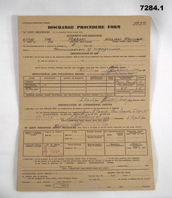
Administrative record - DISCHARGE PROCEDURE 1957, Australian Military Forces, 5.4.1957
William Malcom (Bill) Forrest, served Korea and Malaya. Refer Cat No 7281P for both of his service engagements..1) .2) Discharge Procedure forms AAF A 102, card. .1) brown colour .2) light brown. All print in black, entries in red pen, others in blue pen, both have been stamped. .1) Appears to be an initial one and .2) a completed form.Main points: "5/1788 SPR Forrest - William Malcolm - Termination of engagement" Stamped, "Passed X Ray" Stamped, "AHQ Svy Regt - R Aust Svy" - "CO AHQ Survey Regiment"administrative record, form, korea, malaya -
 Federation University Historical Collection
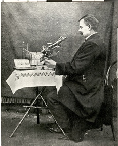
Photograph - Photograph - Black and White, John Brittain
On 28 June 1907 John Brittain, a well known writer and lecturer on astronomical subjects was appointed lecturer and demonstrator in Astronomy in the Department of Engineering and Surveying at the Ballarat School of Mines. A man in a jacket looks toward a microscope on a table with white tablecloth. The man is John Brittain who lectured at the Ballarat School of Mines. ballarat school of mines, scientific equipment, microscope, john brittain, astronomy, astronomical, scientific objects, observatory -
 Bendigo Military Museum
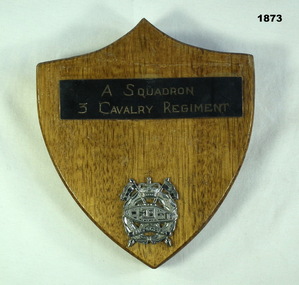
Souvenir - SHIELD 3 CAV, C.1960’s
Item in the collection re Geoff Murray No 3411521, served Vietnam with 3 Cavalry Regt 27.11.1967 to 22.10.1968, Survey Corp 15.10.1969 to 15.10 1970. refer Cat No 638P.Wooden shield shape with metal plaque reading "A Squadron 3 Cavalry Regiment" and that unit's badge in silver coloured metal.military history-regimental shield, 3 cav -
Federation University Historical Collection
Equipment - Scientific Instrument, T. Cooke & Sons Ltd, Theodolite, early 1900s
The theodolite is used in surveying and measures vertical and horizontal angles. Placed on a tripod, it is used to find angles in road building, tunnel alignment and other civil engineering work. The theodoliteTheodolite with four levelling screws. External focusing.ballarat school of mines, surveying, engineering, cooke, theodolite, scientific instrument -
 Orbost & District Historical Society
map/brochure, Discovering Marlo & The Snowy River Estuary, December 1988
In 1983 the Department of Conservation, Forests and Lands replaced the Department of Crown Lands and Survey, the Department of State Forests and the Ministry for Conservation. This brochure/map was used as tourist information in Orbost.This item is a useful research tool.A folded map/brochure titled "DISCOVERING MARLO & THE SNOWY RIVER ESTUARY". On the front is a photograph of Marlo and the title in yellow print. There is a locality map for access to Corringle beach and the brochure Includes a key to fishing sites and various tourist locations. On the back of the brochure are notes on fishing, wildlife and a boating guide, map brochure snowy-river marlo -
 Bendigo Military Museum
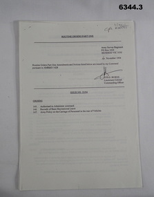
Administrative record - Army Survey Regiment - Routine Orders Part1 1994, Army Survey Regiment, Bendigo, 1, 4 Nov 1994, .2, 16 Nov 1994, .3, 25 Nov 1994
Army Survey Regiment published Unit Administrative Routine Orders regularly. .1 is issue 25/94, .2 is issue 26/94 and .3 is Issue 27/94.1, .2, .3 are all A4 sheets of paper stapled top left royal australian survey corps, rasvy, fortuna, army survey regiment, army svy regt, asr -
 Bendigo Military Museum
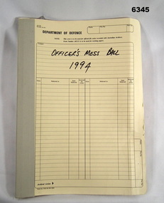
Administrative record - Army Survey Regiment Officers Mess Ball 1994, Army Survey Regiment, Bendigo, February 1994
The Army Survey Regiment held Annual Balls at Fortuna Villa. This folder contains the documentation for the Logistics and activities associated with the planning and running of the Officers Mess Ball held in 1994.Cloth bound manilla Correspondence File containing A4 paper documentsroyal australian survey corps, rasvy, fortuna, army survey regiment, army svy regt, asr -
 Bendigo Military Museum
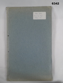
Administrative record - Army Survey Regiment Officers Mess Ball 1991, Army Survey Regiment, Bendigo, February 1991
The Army Survey Regiment held Annual Balls at Fortuna Villa. This folder contains the documentation for the Logistics and activities associated with the planning and running of the Officers Mess Ball held in 1991.Carboard Folder, blue, containing correspondence, invitations, photos and diagrams.royal australian survey corps, rasvy, fortuna, army survey regiment, army svy regt, asr -
 Bendigo Military Museum
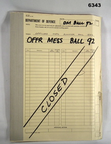
Administrative record - Army Survey Regiment Officers Mess Ball 1992, Army Survey Regiment, Bendigo, 1992
The Army Survey Regiment held Annual Balls at Fortuna Villa. This folder contains the documentation for the Logistics and activities associated with the planning and running of the Officers Mess Ball held in 1992.Correspondence Manilla Folder with cloth binding, Contains correspondence, photographs and diagrams.royal australian survey corps, rasvy, fortuna, army survey regiment, asr -
 Bendigo Military Museum
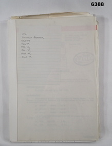
Administrative record - I Fd Svy Sqn Monthly Report: Jan - Jun 1979, 1 Fd Svy Sqn, 30 Jun 1979
Report covering the activities of 1 Fd Svy Sqn between Jul 78 to Sep 78. Monthly Reports were mandatory for Royal Australian Survey Corps unitsPlastic, Cardboard covered, A4 Paper reports, diagrams. Loose pages and pictorial Index at rearroyal australian survey corps, rasvy, fortuna, army survey regiment, army svy regt, asr -
 Bendigo Military Museum
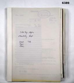
Administrative record - I Fd Svy Sqn Monthly Report: Oct - Dec 1978, 1 Fd Svy Sqn, 1978
Report covering the activities of 1 Fd Svy Sqn between Oct 78 to Dec 78. Monthly Reports were mandatory for Royal Australian Survey Corps unitsPlastic, Cardboard covered, A4 Paper reports, diagrams. Pictorial Index at rear.royal australian survey corps, rasvy, fortuna, army survey regiment, army svy regt, asr -
 Bendigo Military Museum
Photograph - Print Troop – Lithographic Squadron – Army Survey Regiment, Fortuna, Bendigo
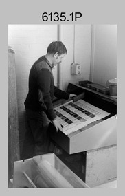
This collection of 23 photos was most likely taken in Lithographic Squadron, Army Survey Regiment, Fortuna, Bendigo, in 1988. In photos .1P and .2P the technician is preparing a Chromalin map proof for supporting information that would be printed on the reverse side of a topographic map. This map was commonly referred to as a ‘snack’ map, with photos of edible indigenous plants and descriptions endemic to that region printed on the reverse side to assist soldiers living off the land in survival situations. The authoritative information was provided by Major Leslie James (Les) Hiddins aka ‘the Bush Tucker Man’ He is a retired Australian Army soldier and war veteran, who is best known for his love and knowledge of the Australian bush. See item 6190.6P for more information on the Chomalin proof production process. In the remaining photos, Print Troop’s technicians were most likely operating the Komoni, Planeta or Ultra-MAN-III offset printing presses, as well as working in the map despatch dock. Although these photos are not annotated most personnel are positively identified. This is a set of 23 photographs of Print Troop personnel and equipment from Lithographic Squadron at the Army Survey Regiment, Fortuna, Bendigo, 1988. The photographs were on 35mm negative film and were scanned at 96 dpi. They are part of the Army Survey Regiment’s Collection. .1) - Photo, black & white, 1988, Chromalin Proof laminating, Terry King. .2) - Photo, black & white, 1988, Chromalin Proof laminating, Terry King. .3) to .6) - Photo, black & white, 1988, Ultra-MAN-III Printing Press, Colin Yeats. .7) - Photo, black & white, 1988, Ultra-MAN-III Printing Press, L to R: Greg Rowe, SPR Mark ‘Dogs’ Doherty. .8) - Photo, black & white, 1988, Ultra-MAN-III Printing Press, SPR Mark ‘Dogs’ Doherty. .9) to .10) - Photo, black & white, 1988, Ultra-MAN-III Printing Press, John Bateman. .11) - Photo, black & white, 1988, Ultra-MAN-III Printing Press. .12) - Photo, black & white, 1988, Map laminator? L to R: SGT Dale Hudson, SGT Gary Kerr. .13) - Photo, black & white, 1988, Newkoni Komori Printing Press, Peter Hamilton. .14) to .17) - Photo, black & white, 1988, Original Heidelberg Printing Press, Peter Hamilton. .18) to .19) - Photo, black & white, 1988, Map Despatch area, SPR Steve Wright. .20) - Photo, black & white, 1988, Map Despatch area, L to R: unidentified, SGT Gary Kerr. .21) - Photo, black & white, 1988, Printing Presses - foreground: Ultra-MAN-III (x2), centre: Newkoni Komori and background: Planeta Polygraph. .22) - Photo, black & white, 1988, Ultra-MAN-III Printing Presses (x2). .23) - Photo, black & white, 1988, L to R: Daryl South, Mark McCulloch.No personnel are identifiedroyal australian survey corps, rasvy, army survey regiment, army svy regt, fortuna, asr, litho, printing -
 Federation University Historical Collection
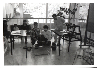
Photograph - Black and White Photograph, Ballarat Institute of Advanced Education Students Engaged in Structural Work on Open Day, 1989, c1974
.1 & .2 - Civil Engineering student practical work examples .3 - First year Engineering students' competition : design, built and tested specified braced truss. Testing usually done during Open Day. .4 - Thermodynamics laboratory colorimetry room. reproduced in the 1975 Handbook, p 90Images of students engaged in structural work. .1) Three people at a load frame with a roof tress element. .2) A male student at an electronic surveying instrument. .3) Several people around a test setup for a student made model truss. .4) Three male persons at an experimental setup involving a garbage bin.ballarat institute of advanced education, civil engineering, laboratory, open day, thermodynamics, lloyd payne, alumni, trevor gourley -
 Federation University Art Collection
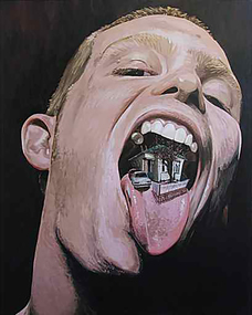
Painting - Artwork - Painting, Duncan Lannan, 'Self Portrait at Home' by Duncan Lannan, c2006
‘Self portrait at home’ This artwork was conceived after a series of paintings depicting the interior of my home in Ballarat. Those paintings began as glimpses around the house, mostly captured at night, of hallways, darkened corners, and ominous entrances into bedrooms. Later on I began to fill these spaces with a figure, that of my girlfriend (now wife), and conducted portraits of her placed amongst the shadows in a deliberate attempt to conjure up associations of Baroque painting as well as still images from horror films. I wanted to see what was sinister in this house, to imagine it, as well as observing it directly. ‘Self portrait at home’ is an attempt at summarising the combination of imagination and observation, of wandering through interior spaces as well as being absorbed in it: that what we see is then also taken into our consciousness, or in the case of this painting what we see is about to be swallowed. This concept of combining what is observed with what is imagined and using references to the physical body as a kind of mediator of this process is expressed in Kenneth Slessor’s poem ‘South Country’, a poem that partly inspired my approach to this painting. The following verses provide an example: And over the flat earth of empty farms The monstrous continent of air floats back Coloured with rotting sunlight and the black, Bruised flesh of thunderstorms: Air arched, enormous, pounding the bony ridge, Ditches and hutches, with a drench of light, So huge, from such infinities of height, You walk on the sky’s beach ‘Self portrait at home’ may not express itself as seriously as Slessor’s poem does but I hope it shows the impact as well as the texture and flavour that houses of the Ballarat landscape, and those of the imagination, can have. Duncan LannanDuncan LANNAN (1972- ) Duncan Lannan undertook a Diploma of Arts (Visual Arts) at RMIT between 1995 and 1996. A further two years study at the University of Ballarat (now Federation University Australia) saw Duncan Lannan awarded a Bachelor of Arts (Visual Arts) in 2000. He completed a Graduate Diploma of Education at the University of Melbourne in 2001. Duncan Lannan's exhibition 'Young, Dumb and Full of Ambition!' was held at the Art Gallery of Ballarat from 13 July to 11 September 2014.ContemporarySelf portrait of the artist with mouth open, and a house on the tongue. This piece was exhibited at the Art Gallery of Ballarat in 2007 in the "Eye to I" exhibition which was curated by former Federation University Art theory lecturer Geoff Wallis. The exhibition was a survey of self portraits by Australian contemporary artists. Gift of Geoff and Nola Wallis, 2017duncan lannan, painting, portrait, alumni, available -
 University of Melbourne, Burnley Campus Archives
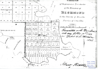
Plan - Sketch, Sketch of the Proposed Boundaries of the Village of Richmond, 1843
Sketch of the proposed boundaries of the village of Richmond in the County of Bourke Parish of Jika-Jika. Handritten, "Transmitted with Descriptioon and my letter No 43/150 Dated 11th November 1843 Robert Hoddle." Shows Burnley Gardens site as, "Reserve. Survey Department." From Central Plan Office, Department of Natural Resources and Environmentrichmond, jika-jika, robert hoodle -
 Villa Alba Museum
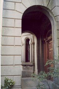
Photograph - Arched entrance to portico, c.1987
Built for William and Anna-Maria Greenlaw in the early 1880s, and with interiors decorated by the Paterson Bros, Villa Alba remained in private ownership until 1949. From 1950, the house was owned by a number of institutions. By 1984, the Villa Alba Preservation Society had been formed, and three years later, the Mount Royal Hospital granted a 25-year lease to Kew Council. In 2004, the title to Villa Alba was passed by the Victorian Government to The Villa Alba Museum Incorporated. The Museum, at 44 Walmer Street, Kew, is now a cultural institution committed to the collection, study and display of 19th century interior decorative finishes, and the components of 19th and 20th century interior decoration.This is one of a number of historically and aesthetically significant photos of the interiors and exterior of Villa Alba when it was still owned by the Mount Royal Hospital, showing twentieth century accretions and deterioration of the historic fabric of the building. This was a benchmark survey against which future conservation and restoration activities can be measured.In December 1987, Mockridge Stahle & Mitchell Pty Ltd Architects prepared ‘Villa Alba Survey: A Report on the fabric for Mount Royal Hospital’ of which this photograph is a part. Photo of one of two arched entrances to the portico on the ground floor with the main entrance door. Above this raised portico is the central tower at the front of the house. villa alba museum, conservation photographs, victorian architecture, porticos, towers, romanesque revival arches -
 Villa Alba Museum
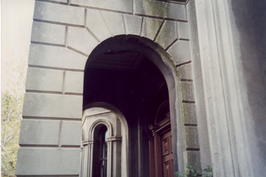
Photograph - Arched entrance to portico, c.1987
Built for William and Anna-Maria Greenlaw in the early 1880s, and with interiors decorated by the Paterson Bros, Villa Alba remained in private ownership until 1949. From 1950, the house was owned by a number of institutions. By 1984, the Villa Alba Preservation Society had been formed, and three years later, the Mount Royal Hospital granted a 25-year lease to Kew Council. In 2004, the title to Villa Alba was passed by the Victorian Government to The Villa Alba Museum Incorporated. The Museum, at 44 Walmer Street, Kew, is now a cultural institution committed to the collection, study and display of 19th century interior decorative finishes, and the components of 19th and 20th century interior decoration.This is one of a number of historically and aesthetically significant photos of the interiors and exterior of Villa Alba when it was still owned by the Mount Royal Hospital, showing twentieth century accretions and deterioration of the historic fabric of the building. This was a benchmark survey against which future conservation and restoration activities can be measured.In December 1987, Mockridge Stahle & Mitchell Pty Ltd Architects prepared ‘Villa Alba Survey: A Report on the fabric for Mount Royal Hospital’ of which this photograph is a part. Photo of one of two arched entrances to the portico on the ground floor with the main entrance door. The cement render is detailed to resemble stone block work.villa alba museum, conservation photographs, victorian architecture, porticos, towers, romanesque revival arches, cement render -
 Melbourne Tram Museum
Document - Research Notes, H. S. McComb, notes on the PMTT depots, 1950's
Set of papers - 20 hand prepared foolscap sheets, giving notes on the PMTT depots, extracts from Surveyor field books, notes on doubtful matters, sketches of curves, surveyor notes, relevant dates of surveys, Items 2041 to 2052 within box 72.3 in a brown folder marked "PMTT" in red pencil.trams, tramways, pmtt, malvern, routes, track, malvern depot, kew depot, surveys -
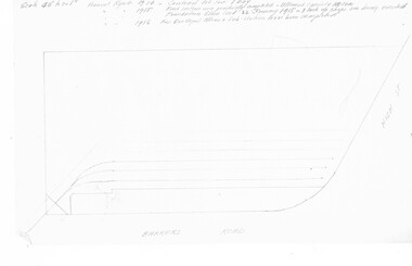
Bendigo Historical Society Inc.
Document - MARKS COLLECTION: PLAN OF SANDHURST CITY CENTRE AND SURROUNDING AREA ( NO. 2 )
Plan drawn on heavy parchment. Written on plan Sandhurst Sheet No. 2. (See record 8300.58 for continuation of plan into city centre) Plan shows allotments with owner names, where applicable. Quartz crushing machines marked. On bottom lithographed at the Department of Lands and Survey, Melbourne, by D. Henerson, March 12th., 1867.bendigo, planning, sandhurst -
 Bendigo Historical Society Inc.
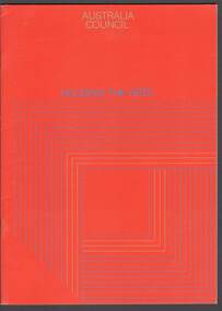
Document - MERLE HALL COLLECTION: ''HOUSING THE ARTS'' AUSTRALIA COUNCIL
''Housing the Arts - Establishing Community Arts Centres or Performing Arts Facilities'' Australia Council 1979. 22 page booklet - Synopsis of a survey and report on 30 community arts centres and civic centres in Australia - with brief descriptions of facility and photograph. Introduction of a Resource Kit for Local Councils and arts organizations. (2 copies). -
Bendigo Historical Society Inc.
Map - SANDHURST : COUNTY OF BENDIGO, 12-7-27
Map. Sandhurst, County of Bendigo. Scale 20 chains to an inch. Huntly, Nerring, Marong, Mandurang, Strathfieldsaye, Wellsford, City of Bendigo. Photo-Lithographed at the Department of Lands and Survey, Melbourne by W.J. Butson12-7-27. Price 1/-. By authority H.J. Green, Govt. Printer. (number 33 in map cupboard 1)H.J. Green, Govt. Printer.map, bendigo, sandhurst -
Bendigo Historical Society Inc.
Map - TANDARRA : COUNTY OF BENDIGO, 14-3-24
Map. Tandarra, County of Bendigo, Talambe, Yallook, Neilborough, Whirrakee, Kamarooka. Myers Creek, Tandarra Estate. Photo-Lithographed at the Department of Lands and Survey, Melbourne by W.J. Butson, 14-3-24. Price 1/-. By authority Albert J. Mullett, Government Printer, Melbourne. (number 25 in map cupboard 1)Albert J. Mullett, Government Printer, Melbourne.map, bendigo, tandarra -
 Bendigo Historical Society Inc.
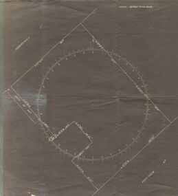
Document - SURVEY PLAN OF HARGREAVES & HOPETOWN STREETS
Undated survey plan by William Bockli, Consulting Engineer 422-428 Collins St Melbourne showing land between Hargreaves St and Hopetoun St Bendigo, stamped 'Hanro Aust Bendigo Knitting Mill, PTY,LTD., Job 37, drawing No 8. Scale . 30 feet to an inch. Unknown donorbendigo, industry, hanro knitting mill -
Bendigo Historical Society Inc.
Map - POMPAPIEL : COUNTY OF BENDIGO, 1-10-27
Map. Pompapiel, County of Bendigo, Calivil, Talambe, Yallook, Salisbury, Yarrayne, Janiember East, Waranga Mallee Channel, Blind Creek, Judyong Creek, Bullock Creek. Photo-Lithographed at the Dept. of Lands and Survey Melbourne by W.J. Butson 1-10-27. Price 1/-. (number 85 in map cupboard 1)W.J. Butsonmap, bendigo, pompapiel -
Bendigo Historical Society Inc.
Map - POMPAPIEL : COUNTY OF BENDIGO, 1-10-27
Map. Pompapiel, County of Bendigo, Calivil, Talambe, Yallook, Salisbury, Yarrayne, Janiember East, Waranga Mallee Channel, Judyong Creek.Pompapiel Creek, Bullock Creek, Blind Creek. Photo-Lithographed at the Department of Lands and Survey by W.J. Butson, 1-10-27. Price 1/-. (number 84 in map cupboard 1)W.J. Butson.map, bendigo, pompapiel