Showing 1944 items
matching victoria bridge
-
 Lakes Entrance Regional Historical Society (operating as Lakes Entrance History Centre & Museum)
Photograph, 1947
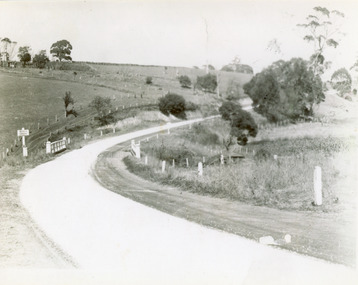
1/02/1947 12:00:00 AMBlack and white photograph of the Princes Highway bridge over Bunga Creek showing the sharp bend in the road as it crosses the creek east of Lakes Entrance Victoriabridges, transport, waterways -
 Lakes Entrance Regional Historical Society (operating as Lakes Entrance History Centre & Museum)
Photograph, 1932
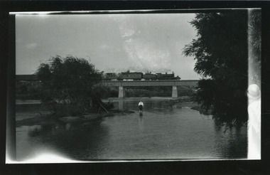
Bairnsdale or Orbost railway closed to passengers 27 April 1935Black and white photograph of a steam train passing over the Tambo River bridge showing a passenger carriage behind the locomotive, man paddling in river. Bruthen Victoriabridges, transport, boats and boating -
 Lakes Entrance Regional Historical Society (operating as Lakes Entrance History Centre & Museum)
Photograph, 1940
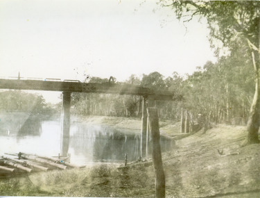
Black and white photograph of a railway bridge over waterway on railway line at unknown location. Boat at edge of water has small load of log timbers across it. Victoriabridges, transport, vegetation -
 Lakes Entrance Regional Historical Society (operating as Lakes Entrance History Centre & Museum)
Photograph, 1930
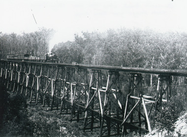
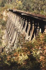
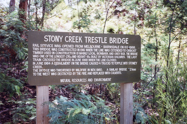
Also similar black and white copy 15 x 22 cmBlack and white photograph showing the trestle bridge over Stoney Creek near Nowa Nowa, shows Bairnsdale to Orbost train on left end of bridge. Train has four open goods trucks, two covered goods trucks, one louvred van and one passenger carriage, and guards van at rear. Tall forest in background, low scrub in front. Nowa Nowa Victoria.bridges, transport -
 Lakes Entrance Regional Historical Society (operating as Lakes Entrance History Centre & Museum)
Photograph, Bennett, Vera, 1989
Date made June 1989|Two photographs taken by Vera Bennett| One photograph taken by Keith Scarce|Six photographs all similar views of trestle bridgeColour photograph of the trestle railway bridge over Stoney Creek, near Nowa Nowa, showing bridge in intact condition soon after the cessation of services from Bairnsdale to Orbost. Nowa Nowa Victoriabridges, transport -
 Lakes Entrance Regional Historical Society (operating as Lakes Entrance History Centre & Museum)
Photograph, Holding, M and Gibson, Tim, 1999
Photographs taken for Heritage Study|Eight other photographs similar viewsColour photographs showing different views of the railway bridge at Stoney Creek near Nowa Nowa, Victoriatransport, boats and boating -
 Lakes Entrance Regional Historical Society (operating as Lakes Entrance History Centre & Museum)
Photograph, Lakes Post Newspaper, 1999
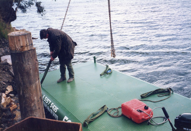
Photo and article appeared in the Lakes Post Newspaper 28 July 1999|Barge was built by Wayne Smith for the firm East Gippsland Bridges.|Also two other photographs similarColour photograph of the launching of a new work barge in the Tambo River, Victoria.boats and boating, topography, waterways, celebrations -
 Lakes Entrance Regional Historical Society (operating as Lakes Entrance History Centre & Museum)
Photograph, 1999
... by Marine Parade and the highway approach to North Arm Bridge, Lakes... Arm Bridge, Lakes Entrance, Victoria. Photograph ...In late 1958 bore put down in an attempt to obtain good quality water for a reticulated town water supply. Water unsuitable, but during drought years when water supply from Nicholson River was restricted, water from this bore available for public use. Bore plugged, structure removed December 2000. Site marked with plaque March 2001, by Lakes Entrance Historical Society.Colour photograph of the head works including feed pipe of water bore sunk in late 1958 on the Public Reserve bound by Marine Parade and the highway approach to North Arm Bridge, Lakes Entrance, Victoria.sports -
 Lakes Entrance Regional Historical Society (operating as Lakes Entrance History Centre & Museum)
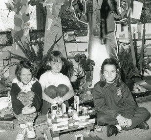
Photograph, Lakes Post Newspaper, 1994
... bridge Lakes Entrance Victoria.... McKenzie, making a Lego bridge Lakes Entrance Victoria. Photograph ...Black and white photograph of primary school students Aleisha Burnett, Melanie McPhee and Megan McKenzie, making a Lego bridge Lakes Entrance Victoria.schools -
 Lakes Entrance Regional Historical Society (operating as Lakes Entrance History Centre & Museum)
Photograph, M Fish, 1970 c
Bridge built 1916 to 1917 demolished after opening of new bridgeColour photograph of concrete bridge over North Arm taken from Eastern side of bridge southern shore of North Arm Lakes Entrance Victoriapolice -
Lakes Entrance Regional Historical Society (operating as Lakes Entrance History Centre & Museum)
Photograph, 1970 c
Photograph shows no buildings on Kalimna escarpment skylineColour photograph of concrete bridge over North Arm taken from western side of bridge south shore of North Arm Lakes Entrance Victoriapolice -
Lakes Entrance Regional Historical Society (operating as Lakes Entrance History Centre & Museum)
Photograph, M Fish, 1980 c
Second colour photograph shows continuation of scene westward along Reeves Channel Fraser Island visible to South number 04200.1 size 10 x 15 cmColour photograph taken from Kalimna jetty of Northern Shore of Kalimna Cove showing dense vegetation above rock wall and sandy shore Kalimna Victoriabridges, waterways -
Lakes Entrance Regional Historical Society (operating as Lakes Entrance History Centre & Museum)
Postcard, H D Bulmer, 1927 c
Black and white postcard taken from Jemmys Point looking West showing boat on lake Rigby Fraser and Flannagan Islands to South steep wooded shoreline to North Lakes Entrance VictoriaThe Lakes from Jemmys Point Lakes Entrancebridges, waterways -
Lakes Entrance Regional Historical Society (operating as Lakes Entrance History Centre & Museum)
Postcard, H D Bulmer, 1950 c
Also a cut down colour photograph of second humpy bridge to Bullock Island donated by M Fish number 04208.1 size 3 x 13 cm|Also two black and white photographs numbers 04208.2 and 04208.3 in SparesColour tinted postcard of Bullock Island and first traffic bridge. Island has no development.North Arm bridge and Princes Highway in foreground, New Works area across Cunninghame Arm in distance Lakes Entrance VictoriaBullock Island and Bridge Lakes Entranceroads and streets, waterways -
Lakes Entrance Regional Historical Society (operating as Lakes Entrance History Centre & Museum)
Photograph, M Holding, 1988 c
Also two colour photographs showing dumped sand on Bullock Island taken from Princes Highway lower parking bay June 2000. Donor L P Newspaper number 04209.1 size 10 x 15 cm and 04209.2 size 10 x 15 cm|Two colour photographs of Gippsland Ports Facilities taken from waterway numbers 04208.3 and 04208.4 size 10 x 15 cmColour photograph taken from Kalimna Heights showing development on Bullock Island including Pecks Factory. The Club Spit of dredged sand is acquiring vegetation. April Hamer dredge moored at Port Jetty, new bridge in place Lakes Entrance Victoriaislands, waterways -
Lakes Entrance Regional Historical Society (operating as Lakes Entrance History Centre & Museum)
Postcard, H D Bulmer, 1925 c
Black and white postcard of Harpers Bay showing the jetty where tourist launches moored for passengers to land and walk up to Mrs Westersons Cliffcrest Tea Rooms, Jemmys Point in distance Gippsland Lakes VictoriaHarpers Bay Gippsland Lakesbridges, islands, waterways -
Lakes Entrance Regional Historical Society (operating as Lakes Entrance History Centre & Museum)
Photograph, 1928
Also an enlarged copy number 04211.1 size 10 x 15 cmBlack and white photograph showing six adults and a child in the garden at Cliffcrest Tea Gardens above Harpers Bay view of Flannigan Island, lakes and outer barrier in distance, Gippsland Lakes Victoriabridges, dredging, islands, jetties -
Lakes Entrance Regional Historical Society (operating as Lakes Entrance History Centre & Museum)
Postcard, H D Bulmer, 11920 c
Black and white postcard of township showing first concrete bridge over North Arm swamp land behind buildings on Esplanade low sand dunes on outer barrier Lakes Entrance VictoriaLakes Entrance from Princes Highwayislands, roads and streets -
Lakes Entrance Regional Historical Society (operating as Lakes Entrance History Centre & Museum)
Postcard, John Engelander and Co Melbourne, 1970 c
Also identical postcard with message on back in Spares boxColour postcard of view from Princes Highway to town showing concrete bridge over North Arm old toilet block opposite road to Bullock Island, Club Spit being formed, Hill 60 visible on outer barrier hummocks Lakes Entrance Victoriaislands, people, recreational facilities -
Lakes Entrance Regional Historical Society (operating as Lakes Entrance History Centre & Museum)
Postcard, 1972 c
Colour postcard taken from Princes Highway looking down to North Arm bridge with town in distance, people camped on North Arm foreshore and car towing caravan in foreground Lakes Entrance VictoriaGreetings from Lakes Entrancebowls club, topography, waterways -
Lakes Entrance Regional Historical Society (operating as Lakes Entrance History Centre & Museum)
Postcard, 1920 c
Sepia toned postcard showing Eastern Pier, crane on end of pier, glimpse of Western Pier through timber of Eastern Pier Lakes Entrance Victoriabridges, roads and streets, transport, waterways -
Lakes Entrance Regional Historical Society (operating as Lakes Entrance History Centre & Museum)
Photograph, G W Holding, 1/04/1979 12:00:00 AM
Taken during the King of the Straits eventColour photograph taken from Kalimna Heights showing North Arm Bridge, road to Bullock Island, build up of sand spit later site for Fishing Club and boat ramp, Lakes Entrance Victoriajetties, waterways -
Lakes Entrance Regional Historical Society (operating as Lakes Entrance History Centre & Museum)
Photograph, 1/04/1979 12:00:00 AM
Taken during King of the Straits weekendColour photograph taken from Kalimna Heights showing road and bridge to Bullock Island, Apex Park and cars parked on Marine Parade New Works area and Entrance channel in distance Lakes Entrance Victoriaboats and boating, recreation, waterways -
Lakes Entrance Regional Historical Society (operating as Lakes Entrance History Centre & Museum)
Photograph, G W Holding, 1/04/1979 12:00:00 AM
Taken during King of the Straits power boat race Melbourne to Lakes EntranceColour photograph taken from Kalimna Heights showing cars parked at boat ramp on North Arm rear entry to the Club Hotel Club Spit Cunninghame Arm outer barrier and Bass Strait in distance Lakes Entrance Victoriaislands, bridges, waterways -
Lakes Entrance Regional Historical Society (operating as Lakes Entrance History Centre & Museum)
Photograph, M Holding, 1985 c
The town section of North Arm previously known as The BlackwaterColour photograph taken from Kalimna Heights showing outer barrier and entrance channel. Road and new bridge to Bullock Island Apex Park beside North Arm in foreground has old playground equipment with timber fort and hillock with underground tunnel Lakes Entrance Victoriaholland, topography, waterways -
Lakes Entrance Regional Historical Society (operating as Lakes Entrance History Centre & Museum)
Photograph, 2000 c
Also a photograph of Apex Park new slides number 04241.1 size 10 x 15 cmColour photograph of Apex Park showing new adventure playground and barbeque area, new concrete bridge over North Arm in background Lakes Entrance Victoriaislands, recreational facilities, waterfront -
Lakes Entrance Regional Historical Society (operating as Lakes Entrance History Centre & Museum)
Photograph, LE Tidy Town Committee, 1994 c
Colour photograph of picnic area adjacent to Eastern boat ramp on North Arm, old concrete bridge over North Arm in distance Lakes Entrance Victoriarecreational facilities -
Lakes Entrance Regional Historical Society (operating as Lakes Entrance History Centre & Museum)
Photograph, Lakes Post Newspaper, 1995 February
Black and white photograph of North Arm from Marine Parade looking towards North Arm jetty and football ground camping ground Lakes Entrance Victoriabridges, recreational facilities -
Lakes Entrance Regional Historical Society (operating as Lakes Entrance History Centre & Museum)
Photograph, L E Tidy Town Committee
Also another photograph of same area from closer up to jetties and boats number 04244.1 size 10 x 15 cmColour photograph of view of North Arm from Marine Parade Cyprus trees at football ground on far right background, hire boat jetties on right. Lakes Entrance Victoriabridges, recreational facilities -
Lakes Entrance Regional Historical Society (operating as Lakes Entrance History Centre & Museum)
Photograph, Lakes Entrance Tidy Town, 1995 c
Colour photograph showing two children and an adult riding bicycles on pathway between south end of North Arm bridge and Bullock Island road. Middle distance left turn into Marine Parade foreground now site of skate park. In distance palm trees at entry to Esplanade Lakes Entrance Victoriarecreation