Showing 2090 items
matching bendigo maps
-
 Bendigo Historical Society Inc.
Book - BENDIGO THE GOLDEN AGE RETRACED, 1973
Bendigo the golden age retraced Front cover is a map of the area using white lines to point out points of interest in Bendigo. These places are then described in brief detail throught the book. There are also illustrations of each place of interest. Part A has a signature inside the front cover dated 1973. b, has a photo of 'Sun Loong' in front of the Shamrock Hotel, at easter time. This is in a plastic folder which is then inside a folded card, with adrawing of the old Town Hall on the front. C, has a library sticker on the lower spine, numbered 0035 nei. With Index. 64 pages.Jan Neilbendigo, buildings, effects of gold in bendigo., . -
 Bendigo Historical Society Inc.
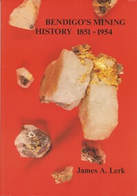
Book - BENDIGO'S MINING HISTORY 1851 - 1954, 1991
Bendigo's Mining History 1851 - 1954. Introduction and overview of gold and mining by the pioneers in the Bendigo area. Contains photographs, Illustrations and Maps. Page 1 has a letter of thanks from James Lerk to the Bendigo Historical Society for use of material in their collection. Autographed by author on 22 July 1991James A. Lerkhistory, mining -
Bendigo Historical Society Inc.
Document - ROBERT DENIS KELLY COLLECTION: MAP OF ELECTRIC RAILWAYS OF LONDON
Document: map of the electric railways of London. Buff coloured document, printed in black, white and red on front cover. Folds into 9 x 14 map. Details include tourist destinations, descriptions of costs etc.Johnson, Riddle & Co. Ltd. London.person, robert denis kelly, world war 1, robert denis kelly collection, france, london, underground, electric railway -
 Bendigo Historical Society Inc.
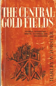
Book - THE CENTRAL GOLD FIELDS, c1969
... and maps. Inscriptions: $1.20, Bendigo Historical Society... and maps. Inscriptions: $1.20, Bendigo Historical Society ...The Central Goldfields, Historical Backgrounds Bendigo, Castlemaine and neighbourhood. Publisher Cypress Books, printed by Cambridge Press, Melbourne. 80 pages. Photographs, illustrations and maps. Inscriptions: $1.20, Bendigo Historical Society. With IndexHarley W Forsterhistory, mining, central goldfields, harley w forster -
 Bendigo Historical Society Inc.
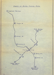
Document - BASIL MILLER COLLECTION: MAP: BENDIGO TRAMWAY ROUTES
... BASIL MILLER COLLECTION: MAP: BENDIGO TRAMWAY ROUTES... COLLECTION: MAP: BENDIGO TRAMWAY ROUTES ...Diagram of Bendigo Tramway Routes. Showing Eaglehawk terminus through to Quarry Hill Terminus and North Bendigo Terminus to Golden Square Terminus. Printed on pale bluish paper with dark blue print.person, individual, baby portrait -
 Bendigo Historical Society Inc.
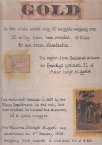
Document - 'GOLD' POSTER WITH DESCRIPTION OF NUGGETS
Poster heading - 'Gold' - 'In the whole world, only 47 nuggets weighing over 30lbs Troy have been recorded. Of these 40 are from Australia. The region from Ballarat around to Bendigo yielded 32 of these large nuggets. This monument erected in 1897 by the Mines Department, is the only one ever erected to honour the discovery of a gold nugget. The 'Welcome Stranger' nugget was unearthed on 5th February, 1869, weighing 2316 ounces and it was sold for 9.553 pounds'. Poster includes a map of Victoria depicting the main gold mining areas, also mention of gypsum, and tin in northern Victoria. A photo of the monument to the discovery of the 'Welcome Stranger' nugget found 1 1/4 miles from Moliagul in the bottom corner.document, gold -
 Bendigo Historical Society Inc.
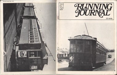
Document - BASIL MILLER COLLECTION: TRAMS - 'RUNNING JOURNAL', April 1971
Journal of the Tramway Museum Society of Victoria Ltd. Volume 8, No. 2, April 1971, 35 cents. Sixteen pages. Cover photo (right) show D class no. 99 sits at the side of the road at Inglewood. On back cover (left), show A class no. 121 sitting in front on an E car and D car at the siding in 1958. Article in this journal wrote about electric trams transport in Perth, include planning routes map. History of object: Part of 'Basil Miller Tramways Collection'cottage, miners -
 Bendigo Historical Society Inc.
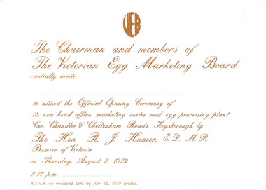
Document - CEPA COLLECTION: VICTORIAN EGG MARKETING BOARD OFFICIAL OPENING
Victorian egg board (VEB) official opening - Thursday 2 August 1979 Three cards a official invitation to opening - white card with brown printing b VEB official Oening response card - yellow card with brown printing c VEB official opening Directional Map - yellow card with brown printing -
 Bendigo Historical Society Inc.
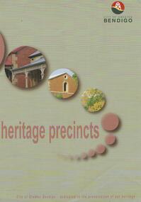
Map - HERITAGE PRECINCTS
... Inc. History House 11 Mackenzie Street Bendigo goldfields MAP ...Map. Heritage precincts. City of Greater Bendigo - dedicated to the preservation of our heritage.map, bendigo, heritage precincts -
Bendigo Historical Society Inc.
Map - BENDIGO AERIAL MAP 2007
... BENDIGO AERIAL MAP 2007... of Defence photomap Bendigo Australia WGS84. Map BENDIGO AERIAL MAP ...Written on bottom of map ' Australian Government Department of Defence photomap Bendigo Australia WGS84. -
Bendigo Historical Society Inc.
Map - WALL MAP
Paper on canvas wall map. Street and Road map of City of Greater Bendigo, Borough of Eaglehawk and Surrounding Districts. Wooden hanging rod on top edge. Plastic rod on lower edge. Light brown background. Tw hanging tapes at centre of top hanging rod. Printed in black and red. Includes Street indexes, historical information and key to points of interest. -
 Bendigo Historical Society Inc.
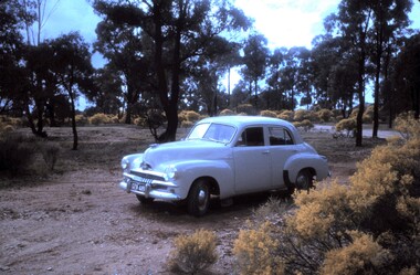
Slide - PETER ELLIS COLLECTION: SLIDE, May 1970 - Jan 1972
Coloured slide transparency. Image is of a car parked in a bush setting off a road. The car is a light coloured FJ Holden and is parked on dirt amongst low scrub and trees in the background. The words The car used to map the Whipstick are handwritten along the top border and the words The Whipstick Car Aug 31st 1974 are handwritten along the bottom border.Kodachrome Transparencyslide, bendigo, bendigo institute of technology -
 Bendigo Historical Society Inc.
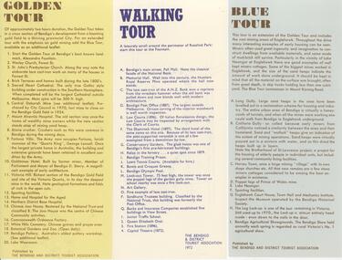
Document - BENDIGO TOURISM BROCHURES COLLECTION: THREE SINGLE SHEET TOUR BROCHURES, 1960's
Document. Three single sheet tour brochures with maps printed on the Reverse, Published by the Bendigo and District Tourist Association. a. Yellow brochure ""Golden Tour''. Outlines a two hour driving tour of Bendigo and White Hills. b. White brochure outlining ''a Walking Tour'' along Pall Mall and through Rosalind park. c. Blue brochure " Blue Tour''. Outlines a driving tour around Eaglehawk.document, memo, three single sheet tour brochures -
 Bendigo Historical Society Inc.
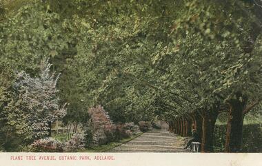
Postcard - GLADYS DEAN COLLECTION: POSTCARD, 1906 - 1908
Coloured photographic postcard with 1cm white border at bottom edge. Image depicts an avenue of plane trees opposite a flower border. A person is seated on a white bench on the right hand side of the avenue. The words Plane Tree Avenue, Botanic Park, Adelaide are printed in red in the border. On the reverse, the words South Australia Post Card are printed with a map of Australia at the top. Card is addressed to Miss R Dean Golden Square Victoria and a one penny stamp is affixed.South Australia Post Cardpostcard -
 Bendigo Historical Society Inc.
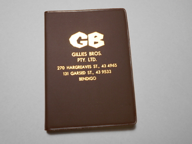
Book - NORM GILLIES COLLECTION: COMPANY PROMOTIONAL POCKET DIARY
Gillies Company promotional gift pocket diary 1985 - blank unused Green plastic cover, with blue text including coloured maps Diary / almanac For 1985, covering 28/12/1984 to 02/01/1986 One of two pocket diaries (1984 diary refer 11850.17) -
 Bendigo Historical Society Inc.
Document - FRIENDS OF WHITE HILLS CEMETERY COLLECTION: BROCHURE, 2014
Brochure. Eaglehawk Monumental Cemetery tour brochure. A tribute to some of the miners from Eaglehawk who lost their lives while on duty. Prepared by Bev Hanson and John Kelly 2014. Map on back of sheet.document, memo, brochure -
Bendigo Historical Society Inc.
Archive - BENDIGO COMPENDIUM 1, 1851-1936
... are 10 books and one large map all relating to Bendigo... and one large map all relating to Bendigo and the surrounding ...DVD. Bendigo Compendium 1 2 discs. In this Compendium are 10 books and one large map all relating to Bendigo and the surrounding districts. -
Bendigo Historical Society Inc.
Map - BLACK'S MAPS CIRCA 1882, 1882
... Bendigo Historical Society Inc. Bendigo Historical Society ...DVD. Black's maps Circa 1882. -
Bendigo Historical Society Inc.
Newspaper - NEWSPAPER COLLECTION: THE SUN WAR MAP SECTION 1944
The Sun - September 2, 1944 (War in the Pacific)newspaper -
Bendigo Historical Society Inc.
Map - GEORGE BLACK REVIEW, 1897
DVD. George Black Review 1979 & 1897. -
Bendigo Historical Society Inc.
Map - GEORGE BLACK 2 REVIEW, 1859-1897
DVD. George Black 2 Review. George Black 1897. William Larritt Drawings 2, William Larritt Drawings 1859. Plus additional data. -
 Bendigo Historical Society Inc.
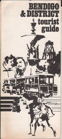
Document - BENDIGO AND DISTRICT TOURIST ASSOCIATION - BENDIGO & DISTRICT TOURIST GUIDE
Pamphlet produced by the Bendigo and District Tourist Association Bendigo & District tourist guide Pamphlet highlights: historic buildings goldmines art gallery, museums, parks and gardens annual features district attractions city and district map One page , four fold pamphletBendigo and District Tourist Association -
 Bendigo Historical Society Inc.
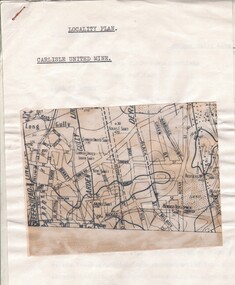
Document - CARLISLE UNITED MINE - LOCALITY PLAN
2 typed foolscap copies of notes on the Carlisle United mine on the Garden Gully Line of Reef. One has 10.5 x 14 cm map attached to the front. Notes are the same as 3501.1 notes.mine, gold, carlisle united, carlisle united mine, carlisle united mine locality plan. -
 Bendigo Historical Society Inc.
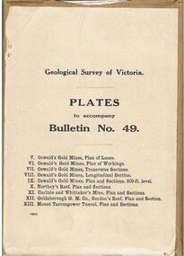
Book - MCCOLL, RANKIN AND STANISTREET COLLECTION: PLATES TO ACCOMPANY BULLETIN NO.49 MALDON GEOLOGICAL SURVEY OF VICTORIA
Book; Brown paper containers with plates (& maps) to accompany bulletin No49 of geological survey of Victoria. V Oswalds G.M. Plan of lease. VI. Oswalds G. M. Plan of workings. VII. Oswalds G. M. Transverse Sect. VIII. Oswalds G. M. Longit. Section. IX. Oswalds G. M. Plan & Sect. 500ft. Level. X. Northey's Reef plan & sections. XI. Carlisle and Whittaker's Mine Plan & Sections.XII. Goldsborough G. M. Co. Gordon's Reef, Plan & Section. XIII. Mount Tarrengower Tunnel Plan & Section.MCCOLL RANKIN & STANISTREETorganisation, industry, surveys, mccoll rankin & stanistreet -
Bendigo Historical Society Inc.
Map - BENDIGO WEEROONA GASWORKS MAP/PLAN COLLECTION: CROWN ALLOTMENTS 13/14, 1942
... BENDIGO WEEROONA GASWORKS MAP/PLAN COLLECTION: CROWN... Inc. History House 11 Mackenzie Street Bendigo goldfields MAP ...Map: crown allotments 13 and 14, Sec. E. City of Bendigo, Parish of Sandhurst. Shows site of Bendigo Gasworks. Prepared by Garnel Gordon Birch Surveyor, 12.6.1942map, bendigo, bendigo weeroona gas works, bendigo, gasworks, gas company, plans -
 Bendigo Historical Society Inc.
Document - CONNELLY, TATCHELL, DUNLOP COLLECTION: LEGAL PAPERS, 1890 1910
Document. Connelly, Tatchell & Dunlop - Legal Papers. 1 - 1910 - Wilson W H Re Income Tax Return. 2 - Map of Tragowel Plains Irrigation Trust, Parish of Mincha West, County of Gunbower, Portion of Allot 77. Shows channel on William Quinlan Junr block and Henry Bott on neighbouring block. 3 - 1893 - Shmick? W N? H. Notes concerning. Mentions Heffernan. 4 - Vear S. Notes concerning. 5 - Notes concerning Adair W. Mentions Goodwin, Receiver of Revenue, Inglewood. 6 - 1893 - Envelope - Returned Letters - addressed to Connelly, Tatchell & Dunlop, Bendigo. 7 - 1910 - Torn letter to Green B, Solicitor, Charlton re Beckham to McGowan.cottage, miners, connelly, tatchell & dunlop, wilson w h, tragowel plains irrigation trust, quinlan william junr, bott henry, shmick? w n?, heffernan, vear s, adair w, goodwin, green b, beckham, mcgowan -
 Bendigo Historical Society Inc.
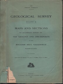
Document - MCCOLL, RANKIN AND STANISTREET COLLECTION: MAPS AND SECTIONS KALGOORLIE, 1929
Document: MCCOLL, RANKIN AND STANISTREET: green cover book Bulletin 94, Maps and Sections to accompany report on the geology and ore deposits of the Boulder Belt, Kalgoorlie. Plages IV - XV11.Government printer, Perthorganization, business, kalgoorlie, mccoll, rankin and stanistreet, kalgoorlie, maps and sections -
Bendigo Historical Society Inc.
Map - MAP: VICTORIA MINING DISTRICTS, MINING DIVISIONS AND THE GOLD FIELDS, 1866
... Inc. History House 11 Mackenzie Street Bendigo goldfields MAP ...Map: printed map stuck on backing paper ( waxed ? ) to support material. Shows mining districts, divisions and goldfields of Victoria. Printed in blue ink on bottom ' this map compiled in 1866. Printed in 1869.' Printed on bottom ' engraved by William Slight under the direction of R. Brough Smyth FGS Lon., the Hon John Macgregor MLA Minister of Mines, published 24th. October, 1866. Revised and corrected by Arthur Everitt, January 25th. 1869. On back of map ' this mapp was compiled by the Mines Department of Victoria 24th. October 1866, corrected by Arthur Everett 15th. January 1869. Presented to the Bendigo Historical Society by E. Hayward 1st. December, 1950.map, victoria, victoria, bendigo, goldfields, gold reefs, mining divisions, map -
Bendigo Historical Society Inc.
Map - MAP: BENDIGO SHEET 2, 1910
... MAP: BENDIGO SHEET 2, 1910... Inc. History House 11 Mackenzie Street Bendigo goldfields MAP ...Map. Map with timber ends, showing names of property owners. Bendigo from Olinda Street west to Prouses Road and Bennet / Wattle Street to Dooley Street in the north. Copy of map taken for research purposes. Map prepared by Department of Lands and Survey, Melbourne by T.F. McGauran 4.1.10 ( 1910 )map, bendigo, bendigo, residence, residence areas, 1910, map -
 Bendigo Historical Society Inc.
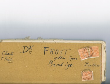
Document - MCCOLL, RANKIN AND STANISTREET COLLECTION: DR FROST, 1920
Correspondence to Dr. Frost re Badak Tin Mine. Binti Binti, Sweet Nell, Bettina, Mascotte & Maconi. Report on inspection of mine reports by Mr. M. Sheard (Mine Manager) & Dr. C. W. Laver of Kalgoorlie, map of Binti lease. Des Frost Golden Square Bendigo Victoria, charts and print.MCCOLL RANKIN & STANISTREETorganization, business, gold mining, mccoll rankin & stanistreet