Showing 2106 items matching "england their england"
-
 Ballarat Heritage Services
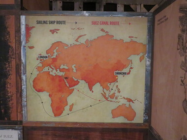
Photograph - Colour, Cutty Sark vessel and exhibition (Sailing Ship Route), Greenwich, England, 2016, 6 November 2016
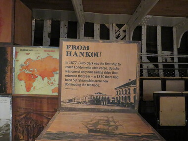
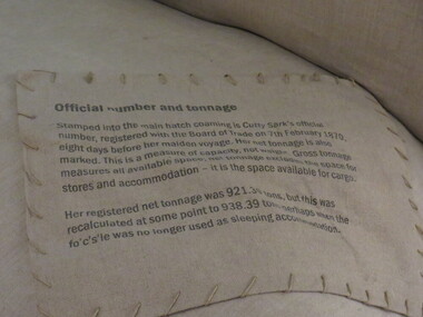
... ), Greenwich, England, 2016... bales and return to England in time for the wool sales ini...England... bales and return to England in time for the wool sales ini ...The Cutty Sark was launched on 22 November 1869. She was named by the wife of George Moodie, the ship's first master who had also supervised her construction. Cutty Sark left the Clyde on 13 January 1870. A month and two days later, she set sail from London for China. Cutty sark was designed and built by Scott & Linton of Dumbarton for 16,150 pounds. But much of the money was to be paid by Willis when the ship was launched. Just before they finished her, Scott & Linton ran out of money and went bankrupt. She was completed by William Denny & Brothers. The Cutty Sark was the first ship to reach London with a tea cargo in 1877. But she was one of only nine sailing ships that returned that year - in 1870 there had been 59. Steamships were now dominating the tea trade. In 1883 the Cutty Sark joined the booming trade in transporting Australian wool. Every year until 1895 she set out in the summer for Australia, to load a cargo of wool bales and return to England in time for the wool sales ini the first three months of the new year. Cutty Sark soon established herself as the fastest of the wool clippers. Under her last master, Richard Woodget she set record times of 70 days or less for the voyage which no other sailing ships could match.cutty sark, exhibition, wool, australia, china, sailing, woodget, moodie, london, willis, dumbarton, scott & linton, william denny, tea, cargo, immigration, trade -
 Ballarat Heritage Services
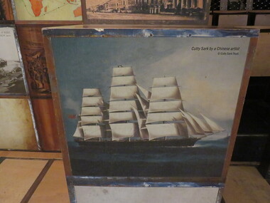
Photograph - Photograph - Colour, Cutty Sark by a Chinese artist, Greenwich, England, 6 November 2016
... Cutty Sark by a Chinese artist, Greenwich, England... bales and return to England in time for the wool sales ini...England... bales and return to England in time for the wool sales ini ...The Cutty Sark was launched on 22 November 1869. She was named by the wife of George Moodie, the ship's first master who had also supervised her construction. Cutty Sark left the Clyde on 13 January 1870. A month and two days later, she set sail from London for China. Cutty sark was designed and built by Scott & Linton of Dumbarton for 16,150 pounds. But much of the money was to be paid by Willis when the ship was launched. Just before they finished her, Scott & Linton ran out of money and went bankrupt. She was completed by William Denny & Brothers. The Cutty Sark was the first ship to reach London with a tea cargo in 1877. But she was one of only nine sailing ships that returned that year - in 1870 there had been 59. Steamships were now dominating the tea trade. In 1883 the Cutty Sark joined the booming trade in transporting Australian wool. Every year until 1895 she set out in the summer for Australia, to load a cargo of wool bales and return to England in time for the wool sales ini the first three months of the new year. Cutty Sark soon established herself as the fastest of the wool clippers. Under her last master, Richard Woodget she set record times of 70 days or less for the voyage which no other sailing ships could match.Painting of a ship called the Cutty Sark.cutty sark, exhibition, wool, australia, china, sailing, ship, woodget, moodie, london, willis dumbarton, scott & linton, william denny, tea, cargo, immigration, trade, chinese -
 Ballarat Heritage Services
Photograph - Colour, Cutty Sark exhibition, Greenwich, England, 2016, 6 November 2016
... Cutty Sark exhibition, Greenwich, England, 2016... bales and return to England in time for the wool sales ini...England... bales and return to England in time for the wool sales ini ...The Cutty Sark was launched on 22 November 1869. She was named by the wife of George Moodie, the ship's first master who had also supervised her construction. Cutty Sark left the Clyde on 13 January 1870. A month and two days later, she set sail from London for China. Cutty sark was designed and built by Scott & Linton of Dumbarton for 16,150 pounds. But much of the money was to be paid by Willis when the ship was launched. Just before they finished her, Scott & Linton ran out of money and went bankrupt. She was completed by William Denny & Brothers. The Cutty Sark was the first ship to reach London with a tea cargo in 1877. But she was one of only nine sailing ships that returned that year - in 1870 there had been 59. Steamships were now dominating the tea trade. In 1883 the Cutty Sark joined the booming trade in transporting Australian wool. Every year until 1895 she set out in the summer for Australia, to load a cargo of wool bales and return to England in time for the wool sales ini the first three months of the new year. Cutty Sark soon established herself as the fastest of the wool clippers. Under her last master, Richard Woodget she set record times of 70 days or less for the voyage which no other sailing ships could match.cutty sark, exhibition, wool, australia, china, sailing, woodget, moodie, london, willis, dumbarton, scott & linton, william denny, tea, cargo, immigration, trade -
 Ballarat Heritage Services
Photograph - Colour, Cutty Sark Exhibition, Greenwich, England, 2016, 6 November 2016
... Cutty Sark Exhibition, Greenwich, England, 2016... bales and return to England in time for the wool sales ini...England... bales and return to England in time for the wool sales ini ...The Cutty Sark was launched on 22 November 1869. She was named by the wife of George Moodie, the ship's first master who had also supervised her construction. Cutty Sark left the Clyde on 13 January 1870. A month and two days later, she set sail from London for China. Cutty sark was designed and built by Scott & Linton of Dumbarton for 16,150 pounds. But much of the money was to be paid by Willis when the ship was launched. Just before they finished her, Scott & Linton ran out of money and went bankrupt. She was completed by William Denny & Brothers. The Cutty Sark was the first ship to reach London with a tea cargo in 1877. But she was one of only nine sailing ships that returned that year - in 1870 there had been 59. Steamships were now dominating the tea trade. In 1883 the Cutty Sark joined the booming trade in transporting Australian wool. Every year until 1895 she set out in the summer for Australia, to load a cargo of wool bales and return to England in time for the wool sales ini the first three months of the new year. Cutty Sark soon established herself as the fastest of the wool clippers. Under her last master, Richard Woodget she set record times of 70 days or less for the voyage which no other sailing ships could match.cutty sark, exhibition, wool, australia, china, sailing, woodget, moodie, london, willis, dumbarton, scott & linton, william denny, tea, cargo, immigration, trade -
 Ballarat Heritage Services
Photograph - Colour, Cutty Sark exhibition, Greenwich, England, 2016, 6 November 2016
... Cutty Sark exhibition, Greenwich, England, 2016... bales and return to England in time for the wool sales ini...England... bales and return to England in time for the wool sales ini ...The Cutty Sark was launched on 22 November 1869. She was named by the wife of George Moodie, the ship's first master who had also supervised her construction. Cutty Sark left the Clyde on 13 January 1870. A month and two days later, she set sail from London for China. Cutty sark was designed and built by Scott & Linton of Dumbarton for 16,150 pounds. But much of the money was to be paid by Willis when the ship was launched. Just before they finished her, Scott & Linton ran out of money and went bankrupt. She was completed by William Denny & Brothers. The Cutty Sark was the first ship to reach London with a tea cargo in 1877. But she was one of only nine sailing ships that returned that year - in 1870 there had been 59. Steamships were now dominating the tea trade. In 1883 the Cutty Sark joined the booming trade in transporting Australian wool. Every year until 1895 she set out in the summer for Australia, to load a cargo of wool bales and return to England in time for the wool sales ini the first three months of the new year. Cutty Sark soon established herself as the fastest of the wool clippers. Under her last master, Richard Woodget she set record times of 70 days or less for the voyage which no other sailing ships could match.cutty sark, exhibition, wool, australia, china, sailing, woodget, moodie, london, willis, dumbarton, scott & linton, william denny, tea, cargo, immigration, trade -
 Ballarat Heritage Services
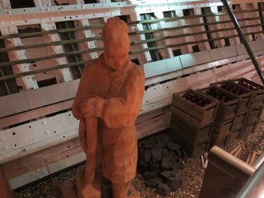
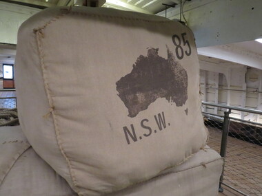
Photograph - Colour, Cutty Sark exhibition, Greenwich, England, showing wool bales from Australia, 2016, 6 November 2016
... Cutty Sark exhibition, Greenwich, England, showing wool... bales and return to England in time for the wool sales ini...England... bales and return to England in time for the wool sales ini ...The Cutty Sark was launched on 22 November 1869. She was named by the wife of George Moodie, the ship's first master who had also supervised her construction. Cutty Sark left the Clyde on 13 January 1870. A month and two days later, she set sail from London for China. Cutty sark was designed and built by Scott & Linton of Dumbarton for 16,150 pounds. But much of the money was to be paid by Willis when the ship was launched. Just before they finished her, Scott & Linton ran out of money and went bankrupt. She was completed by William Denny & Brothers. The Cutty Sark was the first ship to reach London with a tea cargo in 1877. But she was one of only nine sailing ships that returned that year - in 1870 there had been 59. Steamships were now dominating the tea trade. In 1883 the Cutty Sark joined the booming trade in transporting Australian wool. Every year until 1895 she set out in the summer for Australia, to load a cargo of wool bales and return to England in time for the wool sales ini the first three months of the new year. Cutty Sark soon established herself as the fastest of the wool clippers. Under her last master, Richard Woodget she set record times of 70 days or less for the voyage which no other sailing ships could match.cutty sark, exhibition, wool, australia, china, sailing, woodget, moodie, london, willis, dumbarton, scott & linton, william denny, tea, cargo, immigration, trade -
 Ballarat Heritage Services
Photograph - Colour, Cutty Sark exhibition, Greenwich, England, showing wool bales from Australia, looking through to lower deck, 2016, 6 November 2016
... Cutty Sark exhibition, Greenwich, England, showing wool... bales and return to England in time for the wool sales ini...England... bales and return to England in time for the wool sales ini ...The Cutty Sark was launched on 22 November 1869. She was named by the wife of George Moodie, the ship's first master who had also supervised her construction. Cutty Sark left the Clyde on 13 January 1870. A month and two days later, she set sail from London for China. Cutty sark was designed and built by Scott & Linton of Dumbarton for 16,150 pounds. But much of the money was to be paid by Willis when the ship was launched. Just before they finished her, Scott & Linton ran out of money and went bankrupt. She was completed by William Denny & Brothers. The Cutty Sark was the first ship to reach London with a tea cargo in 1877. But she was one of only nine sailing ships that returned that year - in 1870 there had been 59. Steamships were now dominating the tea trade. In 1883 the Cutty Sark joined the booming trade in transporting Australian wool. Every year until 1895 she set out in the summer for Australia, to load a cargo of wool bales and return to England in time for the wool sales ini the first three months of the new year. Cutty Sark soon established herself as the fastest of the wool clippers. Under her last master, Richard Woodget she set record times of 70 days or less for the voyage which no other sailing ships could match.cutty sark, exhibition, wool, australia, china, sailing, woodget, moodie, london, willis, dumbarton, scott & linton, william denny, tea, cargo, immigration, trade -
 Ballarat Heritage Services
Photograph - Colour, Cutty Sark exhibition, Greenwich, England, 6/11/2016
... Cutty Sark exhibition, Greenwich, England... bales and return to England in time for the wool sales ini...England... bales and return to England in time for the wool sales ini ...The Cutty Sark was launched on 22 November 1869. She was named by the wife of George Moodie, the ship's first master who had also supervised her construction. Cutty Sark left the Clyde on 13 January 1870. A month and two days later, she set sail from London for China. Cutty sark was designed and built by Scott & Linton of Dumbarton for 16,150 pounds. But much of the money was to be paid by Willis when the ship was launched. Just before they finished her, Scott & Linton ran out of money and went bankrupt. She was completed by William Denny & Brothers. The Cutty Sark was the first ship to reach London with a tea cargo in 1877. But she was one of only nine sailing ships that returned that year - in 1870 there had been 59. Steamships were now dominating the tea trade. In 1883 the Cutty Sark joined the booming trade in transporting Australian wool. Every year until 1895 she set out in the summer for Australia, to load a cargo of wool bales and return to England in time for the wool sales ini the first three months of the new year. Cutty Sark soon established herself as the fastest of the wool clippers. Under her last master, Richard Woodget she set record times of 70 days or less for the voyage which no other sailing ships could match.cutty sark, exhibition, wool, australia, china, sailing, woodget,, moodie, london, willis, dumbarton, scott & linton, william denny, tea, cargo, immigration, rade -
 Ballarat Heritage Services
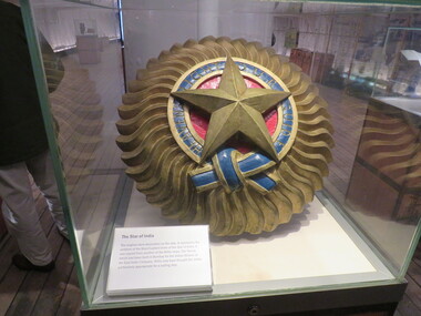
Photograph - Colour, Cutty Sark Exhibition, Greenwich, England, the Star of India, 6 November 2016
... Cutty Sark Exhibition, Greenwich, England, the Star of... bales and return to England in time for the wool sales ini...England... bales and return to England in time for the wool sales ini ...The Cutty Sark was launched on 22 November 1869. She was named by the wife of George Moodie, the ship's first master who had also supervised her construction. Cutty Sark left the Clyde on 13 January 1870. A month and two days later, she set sail from London for China. Cutty sark was designed and built by Scott & Linton of Dumbarton for 16,150 pounds. But much of the money was to be paid by Willis when the ship was launched. Just before they finished her, Scott & Linton ran out of money and went bankrupt. She was completed by William Denny & Brothers. The Cutty Sark was the first ship to reach London with a tea cargo in 1877. But she was one of only nine sailing ships that returned that year - in 1870 there had been 59. Steamships were now dominating the tea trade. In 1883 the Cutty Sark joined the booming trade in transporting Australian wool. Every year until 1895 she set out in the summer for Australia, to load a cargo of wool bales and return to England in time for the wool sales ini the first three months of the new year. Cutty Sark soon established herself as the fastest of the wool clippers. Under her last master, Richard Woodget she set record times of 70 days or less for the voyage which no other sailing ships could match.cutty sark, exhibition, wool, australia, china, sailing, woodget, moodie, london, willis, dumbarton, scott & linton, william denny, tea, cargo, immigration, trade -
 Ballarat Heritage Services
Photograph - Colour, Cutty Sark exhibition, Greenwich, England, the Star of India, 6 November 2016
... Cutty Sark exhibition, Greenwich, England, the Star of... bales and return to England in time for the wool sales ini...England... bales and return to England in time for the wool sales ini ...The Cutty Sark was launched on 22 November 1869. She was named by the wife of George Moodie, the ship's first master who had also supervised her construction. Cutty Sark left the Clyde on 13 January 1870. A month and two days later, she set sail from London for China. Cutty sark was designed and built by Scott & Linton of Dumbarton for 16,150 pounds. But much of the money was to be paid by Willis when the ship was launched. Just before they finished her, Scott & Linton ran out of money and went bankrupt. She was completed by William Denny & Brothers. The Cutty Sark was the first ship to reach London with a tea cargo in 1877. But she was one of only nine sailing ships that returned that year - in 1870 there had been 59. Steamships were now dominating the tea trade. In 1883 the Cutty Sark joined the booming trade in transporting Australian wool. Every year until 1895 she set out in the summer for Australia, to load a cargo of wool bales and return to England in time for the wool sales ini the first three months of the new year. Cutty Sark soon established herself as the fastest of the wool clippers. Under her last master, Richard Woodget she set record times of 70 days or less for the voyage which no other sailing ships could match.cutty sark,, exhibition,, wool, australia, china, sailing, woodget,, moodie, london, willis,, dumbarton, scott & linton, william denny, tea, cargo, immigration, trade -
 Ballarat Heritage Services
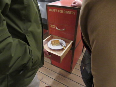
Photograph - Colour, Cutty Sark exhibition, Greenwich, England, What's for dinner?, 6 November 2016
... Cutty Sark exhibition, Greenwich, England, What's for... bales and return to England in time for the wool sales ini...England... bales and return to England in time for the wool sales ini ...The Cutty Sark was launched on 22 November 1869. She was named by the wife of George Moodie, the ship's first master who had also supervised her construction. Cutty Sark left the Clyde on 13 January 1870. A month and two days later, she set sail from London for China. Cutty sark was designed and built by Scott & Linton of Dumbarton for 16,150 pounds. But much of the money was to be paid by Willis when the ship was launched. Just before they finished her, Scott & Linton ran out of money and went bankrupt. She was completed by William Denny & Brothers. The Cutty Sark was the first ship to reach London with a tea cargo in 1877. But she was one of only nine sailing ships that returned that year - in 1870 there had been 59. Steamships were now dominating the tea trade. In 1883 the Cutty Sark joined the booming trade in transporting Australian wool. Every year until 1895 she set out in the summer for Australia, to load a cargo of wool bales and return to England in time for the wool sales ini the first three months of the new year. Cutty Sark soon established herself as the fastest of the wool clippers. Under her last master, Richard Woodget she set record times of 70 days or less for the voyage which no other sailing ships could match.cutty sark, exhibition, wool, australia, china, sailing, woodget, moodie, london, willis, dumbarton, scott & linton, william denny, tea, cargo, immigration, trade -
 Ballarat Heritage Services
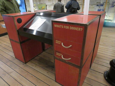
Photograph - Colour, Cutty Sark exhibition, Greenwich, England, What's for dinner?, 06/11/2016
... Cutty Sark exhibition, Greenwich, England, What's for... bales and return to England in time for the wool sales ini...England... bales and return to England in time for the wool sales ini ...The Cutty Sark was launched on 22 November 1869. She was named by the wife of George Moodie, the ship's first master who had also supervised her construction. Cutty Sark left the Clyde on 13 January 1870. A month and two days later, she set sail from London for China. Cutty sark was designed and built by Scott & Linton of Dumbarton for 16,150 pounds. But much of the money was to be paid by Willis when the ship was launched. Just before they finished her, Scott & Linton ran out of money and went bankrupt. She was completed by William Denny & Brothers. The Cutty Sark was the first ship to reach London with a tea cargo in 1877. But she was one of only nine sailing ships that returned that year - in 1870 there had been 59. Steamships were now dominating the tea trade. In 1883 the Cutty Sark joined the booming trade in transporting Australian wool. Every year until 1895 she set out in the summer for Australia, to load a cargo of wool bales and return to England in time for the wool sales ini the first three months of the new year. Cutty Sark soon established herself as the fastest of the wool clippers. Under her last master, Richard Woodget she set record times of 70 days or less for the voyage which no other sailing ships could match.cutty sark, exhibition, wool, australia, china, sailing, woodget, moodie, london, willis, dumbarton, scott & linton, william denny, tea, cargo, immigration, trade -
 Ballarat Heritage Services
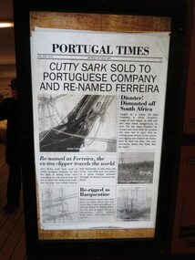
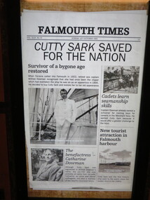
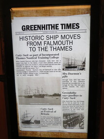
Photograph - Colour, Cutty Sark vessel and exhibition, Greenwich, England, newspaper clipping, 6 November 2016
... Cutty Sark vessel and exhibition, Greenwich, England... bales and return to England in time for the wool sales ini...England... bales and return to England in time for the wool sales ini ...The Cutty Sark was launched on 22 November 1869. She was named by the wife of George Moodie, the ship's first master who had also supervised her construction. Cutty Sark left the Clyde on 13 January 1870. A month and two days later, she set sail from London for China. Cutty sark was designed and built by Scott & Linton of Dumbarton for 16,150 pounds. But much of the money was to be paid by Willis when the ship was launched. Just before they finished her, Scott & Linton ran out of money and went bankrupt. She was completed by William Denny & Brothers. The Cutty Sark was the first ship to reach London with a tea cargo in 1877. But she was one of only nine sailing ships that returned that year - in 1870 there had been 59. Steamships were now dominating the tea trade. In 1883 the Cutty Sark joined the booming trade in transporting Australian wool. Every year until 1895 she set out in the summer for Australia, to load a cargo of wool bales and return to England in time for the wool sales ini the first three months of the new year. Cutty Sark soon established herself as the fastest of the wool clippers. Under her last master, Richard Woodget she set record times of 70 days or less for the voyage which no other sailing ships could match.cutty sark, exhibition, wool, australia, china, sailing, woodget, moodie, london, willis, dumbarton, scott & linton, william denny, tea, cargo, immigration, trade -
 Ballarat Heritage Services
Photograph - Colour, Cutty Sark vessel and exhibition, Greenwich, England, newspaper clipping, 06/11/2016
... Cutty Sark vessel and exhibition, Greenwich, England... bales and return to England in time for the wool sales ini...England... bales and return to England in time for the wool sales ini ...The Cutty Sark was launched on 22 November 1869. She was named by the wife of George Moodie, the ship's first master who had also supervised her construction. Cutty Sark left the Clyde on 13 January 1870. A month and two days later, she set sail from London for China. Cutty sark was designed and built by Scott & Linton of Dumbarton for 16,150 pounds. But much of the money was to be paid by Willis when the ship was launched. Just before they finished her, Scott & Linton ran out of money and went bankrupt. She was completed by William Denny & Brothers. The Cutty Sark was the first ship to reach London with a tea cargo in 1877. But she was one of only nine sailing ships that returned that year - in 1870 there had been 59. Steamships were now dominating the tea trade. In 1883 the Cutty Sark joined the booming trade in transporting Australian wool. Every year until 1895 she set out in the summer for Australia, to load a cargo of wool bales and return to England in time for the wool sales ini the first three months of the new year. Cutty Sark soon established herself as the fastest of the wool clippers. Under her last master, Richard Woodget she set record times of 70 days or less for the voyage which no other sailing ships could match.cutty sark, exhibition, wool, australia, china, sailing, woodget, moodie, london, willis, dumbarton, scott & linton, william denny, tea, cargo, immigration, trade -
 Ballarat Heritage Services
Photograph - Colour, Cutty Sark vessel and exhibition, Greenwich, England, newspaper clipping, 6 November 2016
... Cutty Sark vessel and exhibition, Greenwich, England... bales and return to England in time for the wool sales ini...England... bales and return to England in time for the wool sales ini ...The Cutty Sark was launched on 22 November 1869. She was named by the wife of George Moodie, the ship's first master who had also supervised her construction. Cutty Sark left the Clyde on 13 January 1870. A month and two days later, she set sail from London for China. Cutty sark was designed and built by Scott & Linton of Dumbarton for 16,150 pounds. But much of the money was to be paid by Willis when the ship was launched. Just before they finished her, Scott & Linton ran out of money and went bankrupt. She was completed by William Denny & Brothers. The Cutty Sark was the first ship to reach London with a tea cargo in 1877. But she was one of only nine sailing ships that returned that year - in 1870 there had been 59. Steamships were now dominating the tea trade. In 1883 the Cutty Sark joined the booming trade in transporting Australian wool. Every year until 1895 she set out in the summer for Australia, to load a cargo of wool bales and return to England in time for the wool sales ini the first three months of the new year. Cutty Sark soon established herself as the fastest of the wool clippers. Under her last master, Richard Woodget she set record times of 70 days or less for the voyage which no other sailing ships could match.cutty sark, exhibition, wool, australia, china, sailing, woodget, moodie, london, willis, dumbarton, scott & linton, william denny, tea, cargo, immigration, trade -
 Ballarat Heritage Services
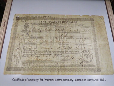
Photograph - Colour, Cutty Sark vessel and exhibition, Greenwich, England, certificate of discharge, 1871, 6 November 2016
... Cutty Sark vessel and exhibition, Greenwich, England... bales and return to England in time for the wool sales ini...England... bales and return to England in time for the wool sales ini ...The Cutty Sark was launched on 22 November 1869. She was named by the wife of George Moodie, the ship's first master who had also supervised her construction. Cutty Sark left the Clyde on 13 January 1870. A month and two days later, she set sail from London for China. Cutty sark was designed and built by Scott & Linton of Dumbarton for 16,150 pounds. But much of the money was to be paid by Willis when the ship was launched. Just before they finished her, Scott & Linton ran out of money and went bankrupt. She was completed by William Denny & Brothers. The Cutty Sark was the first ship to reach London with a tea cargo in 1877. But she was one of only nine sailing ships that returned that year - in 1870 there had been 59. Steamships were now dominating the tea trade. In 1883 the Cutty Sark joined the booming trade in transporting Australian wool. Every year until 1895 she set out in the summer for Australia, to load a cargo of wool bales and return to England in time for the wool sales ini the first three months of the new year. Cutty Sark soon established herself as the fastest of the wool clippers. Under her last master, Richard Woodget she set record times of 70 days or less for the voyage which no other sailing ships could match.cutty sark, exhibition, wool, australia, china, sailing, woodget, moodie, london, willis, dumbarton, scott & linton, william denny, tea, cargo, immigration, trade -
 Ballarat Heritage Services
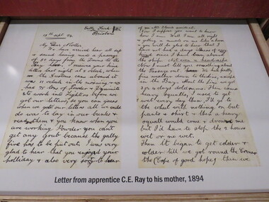
Photograph - Colour, Cutty Sark vessel and exhibition, Greenwich, England, letter written from Brisbane, 1894, 6 November 2016
... Cutty Sark vessel and exhibition, Greenwich, England... bales and return to England in time for the wool sales ini...England... bales and return to England in time for the wool sales ini ...The Cutty Sark was launched on 22 November 1869. She was named by the wife of George Moodie, the ship's first master who had also supervised her construction. Cutty Sark left the Clyde on 13 January 1870. A month and two days later, she set sail from London for China. Cutty sark was designed and built by Scott & Linton of Dumbarton for 16,150 pounds. But much of the money was to be paid by Willis when the ship was launched. Just before they finished her, Scott & Linton ran out of money and went bankrupt. She was completed by William Denny & Brothers. The Cutty Sark was the first ship to reach London with a tea cargo in 1877. But she was one of only nine sailing ships that returned that year - in 1870 there had been 59. Steamships were now dominating the tea trade. In 1883 the Cutty Sark joined the booming trade in transporting Australian wool. Every year until 1895 she set out in the summer for Australia, to load a cargo of wool bales and return to England in time for the wool sales ini the first three months of the new year. Cutty Sark soon established herself as the fastest of the wool clippers. Under her last master, Richard Woodget she set record times of 70 days or less for the voyage which no other sailing ships could match.cutty sark, exhibition, wool, australia, china, sailing, woodget, moodie, london, willis, dumbarton, scott & linton, william denny, tea, cargo, immigration, trade -
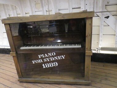 Ballarat Heritage Services
Photograph - Colour, Cutty Sark vessel and exhibition, Greenwich, England, piano crated for Sydney 1889, 6 November 2016
... Cutty Sark vessel and exhibition, Greenwich, England, piano... bales and return to England in time for the wool sales ini...England... bales and return to England in time for the wool sales ini ...The Cutty Sark was launched on 22 November 1869. She was named by the wife of George Moodie, the ship's first master who had also supervised her construction. Cutty Sark left the Clyde on 13 January 1870. A month and two days later, she set sail from London for China. Cutty sark was designed and built by Scott & Linton of Dumbarton for 16,150 pounds. But much of the money was to be paid by Willis when the ship was launched. Just before they finished her, Scott & Linton ran out of money and went bankrupt. She was completed by William Denny & Brothers. The Cutty Sark was the first ship to reach London with a tea cargo in 1877. But she was one of only nine sailing ships that returned that year - in 1870 there had been 59. Steamships were now dominating the tea trade. In 1883 the Cutty Sark joined the booming trade in transporting Australian wool. Every year until 1895 she set out in the summer for Australia, to load a cargo of wool bales and return to England in time for the wool sales ini the first three months of the new year. Cutty Sark soon established herself as the fastest of the wool clippers. Under her last master, Richard Woodget she set record times of 70 days or less for the voyage which no other sailing ships could match.cutty sark, exhibition, wool, australia, china, sailing, woodget, moodie, london, willis, dumbarton, scott & linton, william denny, tea, cargo, immigration, trade -
 Ballarat Heritage Services
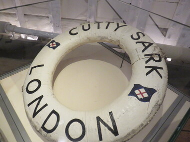
Photograph - Colour, Cutty Sark vessel and exhibition, Greenwich, England, lifebuoy, 6 November 2016
... Cutty Sark vessel and exhibition, Greenwich, England... bales and return to England in time for the wool sales ini...England... bales and return to England in time for the wool sales ini ...The Cutty Sark was launched on 22 November 1869. She was named by the wife of George Moodie, the ship's first master who had also supervised her construction. Cutty Sark left the Clyde on 13 January 1870. A month and two days later, she set sail from London for China. Cutty sark was designed and built by Scott & Linton of Dumbarton for 16,150 pounds. But much of the money was to be paid by Willis when the ship was launched. Just before they finished her, Scott & Linton ran out of money and went bankrupt. She was completed by William Denny & Brothers. The Cutty Sark was the first ship to reach London with a tea cargo in 1877. But she was one of only nine sailing ships that returned that year - in 1870 there had been 59. Steamships were now dominating the tea trade. In 1883 the Cutty Sark joined the booming trade in transporting Australian wool. Every year until 1895 she set out in the summer for Australia, to load a cargo of wool bales and return to England in time for the wool sales ini the first three months of the new year. Cutty Sark soon established herself as the fastest of the wool clippers. Under her last master, Richard Woodget she set record times of 70 days or less for the voyage which no other sailing ships could match.cutty sark, exhibition, wool, australia, china, sailing, woodget, moodie, london, willis, dumbarton, scott & linton, william denny, tea, cargo, immigration, trade -
 Ballarat Heritage Services
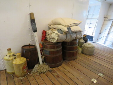
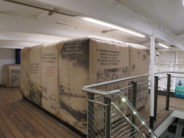
Photograph - Colour, Cutty Sark vessel and exhibition, Greenwich, England, wool bales from Australia, 6 November 2016
... Cutty Sark vessel and exhibition, Greenwich, England, wool... bales and return to England in time for the wool sales ini...England... bales and return to England in time for the wool sales ini ...The Cutty Sark was launched on 22 November 1869. She was named by the wife of George Moodie, the ship's first master who had also supervised her construction. Cutty Sark left the Clyde on 13 January 1870. A month and two days later, she set sail from London for China. Cutty sark was designed and built by Scott & Linton of Dumbarton for 16,150 pounds. But much of the money was to be paid by Willis when the ship was launched. Just before they finished her, Scott & Linton ran out of money and went bankrupt. She was completed by William Denny & Brothers. The Cutty Sark was the first ship to reach London with a tea cargo in 1877. But she was one of only nine sailing ships that returned that year - in 1870 there had been 59. Steamships were now dominating the tea trade. In 1883 the Cutty Sark joined the booming trade in transporting Australian wool. Every year until 1895 she set out in the summer for Australia, to load a cargo of wool bales and return to England in time for the wool sales ini the first three months of the new year. Cutty Sark soon established herself as the fastest of the wool clippers. Under her last master, Richard Woodget she set record times of 70 days or less for the voyage which no other sailing ships could match.cutty sark, exhibition, wool, australia, china, sailing, woodget, moodie, london, willis, dumbarton, scott & linton, william denny, tea, cargo, immigration, trade -
 Ballarat Heritage Services
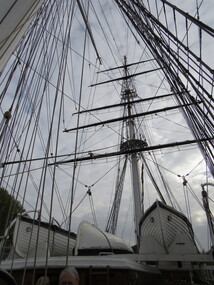
Photograph - Colour, Cutty Sark vessel and exhibition, Greenwich, England, rigging, 06/11/2016
... Cutty Sark vessel and exhibition, Greenwich, England... bales and return to England in time for the wool sales ini...England... bales and return to England in time for the wool sales ini ...The Cutty Sark was launched on 22 November 1869. She was named by the wife of George Moodie, the ship's first master who had also supervised her construction. Cutty Sark left the Clyde on 13 January 1870. A month and two days later, she set sail from London for China. Cutty sark was designed and built by Scott & Linton of Dumbarton for 16,150 pounds. But much of the money was to be paid by Willis when the ship was launched. Just before they finished her, Scott & Linton ran out of money and went bankrupt. She was completed by William Denny & Brothers. The Cutty Sark was the first ship to reach London with a tea cargo in 1877. But she was one of only nine sailing ships that returned that year - in 1870 there had been 59. Steamships were now dominating the tea trade. In 1883 the Cutty Sark joined the booming trade in transporting Australian wool. Every year until 1895 she set out in the summer for Australia, to load a cargo of wool bales and return to England in time for the wool sales ini the first three months of the new year. Cutty Sark soon established herself as the fastest of the wool clippers. Under her last master, Richard Woodget she set record times of 70 days or less for the voyage which no other sailing ships could match.Rigging on the Cutty Sark.cutty sark, exhibition, wool, australia, china,, sailing,, woodget,, moodie, london, willis, dumbarton, scott & linton, william denny, tea, cargo, immigration,, trade, rigging -
 Ballarat Heritage Services
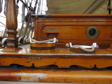
Photograph - Colour, Cutty Sark vessel and exhibition, Greenwich, England, fire buckets, 6 November 2016
... Cutty Sark vessel and exhibition, Greenwich, England, fire... bales and return to England in time for the wool sales ini...England... bales and return to England in time for the wool sales ini ...The Cutty Sark was launched on 22 November 1869. She was named by the wife of George Moodie, the ship's first master who had also supervised her construction. Cutty Sark left the Clyde on 13 January 1870. A month and two days later, she set sail from London for China. Cutty sark was designed and built by Scott & Linton of Dumbarton for 16,150 pounds. But much of the money was to be paid by Willis when the ship was launched. Just before they finished her, Scott & Linton ran out of money and went bankrupt. She was completed by William Denny & Brothers. The Cutty Sark was the first ship to reach London with a tea cargo in 1877. But she was one of only nine sailing ships that returned that year - in 1870 there had been 59. Steamships were now dominating the tea trade. In 1883 the Cutty Sark joined the booming trade in transporting Australian wool. Every year until 1895 she set out in the summer for Australia, to load a cargo of wool bales and return to England in time for the wool sales ini the first three months of the new year. Cutty Sark soon established herself as the fastest of the wool clippers. Under her last master, Richard Woodget she set record times of 70 days or less for the voyage which no other sailing ships could match.cutty sark, exhibition, wool, australia, china, sailing, woodget, moodie, london, willis, dumbarton, scott & linton, william denny, tea, cargo, immigration, trade -
 Ballarat Heritage Services
Photograph - Colour, Cutty Sark vessel and exhibition, Greenwich, England, cafe under ship, 6 November 2016
... Cutty Sark vessel and exhibition, Greenwich, England, cafe... bales and return to England in time for the wool sales ini...England... bales and return to England in time for the wool sales ini ...The Cutty Sark was launched on 22 November 1869. She was named by the wife of George Moodie, the ship's first master who had also supervised her construction. Cutty Sark left the Clyde on 13 January 1870. A month and two days later, she set sail from London for China. Cutty sark was designed and built by Scott & Linton of Dumbarton for 16,150 pounds. But much of the money was to be paid by Willis when the ship was launched. Just before they finished her, Scott & Linton ran out of money and went bankrupt. She was completed by William Denny & Brothers. The Cutty Sark was the first ship to reach London with a tea cargo in 1877. But she was one of only nine sailing ships that returned that year - in 1870 there had been 59. Steamships were now dominating the tea trade. In 1883 the Cutty Sark joined the booming trade in transporting Australian wool. Every year until 1895 she set out in the summer for Australia, to load a cargo of wool bales and return to England in time for the wool sales ini the first three months of the new year. Cutty Sark soon established herself as the fastest of the wool clippers. Under her last master, Richard Woodget she set record times of 70 days or less for the voyage which no other sailing ships could match.cutty sark, exhibition, wool, australia, china, sailing, woodget, moodie, london, willis, dumbarton, scott & linton, william denny, tea, cargo, immigration, trade -
 Ballarat Heritage Services
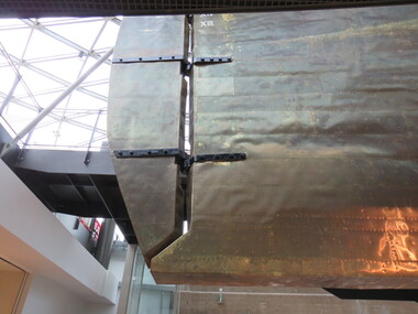
Photograph - Colour, Cutty Sark vessel and exhibition, Greenwich, England, hull and rudder of ship, 6 November 2016
... Cutty Sark vessel and exhibition, Greenwich, England, hull... bales and return to England in time for the wool sales ini...England... bales and return to England in time for the wool sales ini ...The Cutty Sark was launched on 22 November 1869. She was named by the wife of George Moodie, the ship's first master who had also supervised her construction. Cutty Sark left the Clyde on 13 January 1870. A month and two days later, she set sail from London for China. Cutty sark was designed and built by Scott & Linton of Dumbarton for 16,150 pounds. But much of the money was to be paid by Willis when the ship was launched. Just before they finished her, Scott & Linton ran out of money and went bankrupt. She was completed by William Denny & Brothers. The Cutty Sark was the first ship to reach London with a tea cargo in 1877. But she was one of only nine sailing ships that returned that year - in 1870 there had been 59. Steamships were now dominating the tea trade. In 1883 the Cutty Sark joined the booming trade in transporting Australian wool. Every year until 1895 she set out in the summer for Australia, to load a cargo of wool bales and return to England in time for the wool sales ini the first three months of the new year. Cutty Sark soon established herself as the fastest of the wool clippers. Under her last master, Richard Woodget she set record times of 70 days or less for the voyage which no other sailing ships could match.cutty sark, exhibition, wool, australia, china, sailing, woodget, moodie, london, willis, dumbarton, scott & linton, william denny, tea, cargo, immigration, trade -
 Ballarat Heritage Services
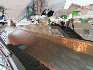
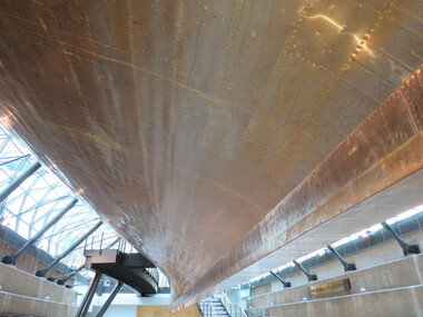
Photograph - Colour, Cutty Sark vessel and exhibition, Greenwich, England, underside of ship, 6 November 2016
... Cutty Sark vessel and exhibition, Greenwich, England... bales and return to England in time for the wool sales ini...England... bales and return to England in time for the wool sales ini ...The Cutty Sark was launched on 22 November 1869. She was named by the wife of George Moodie, the ship's first master who had also supervised her construction. Cutty Sark left the Clyde on 13 January 1870. A month and two days later, she set sail from London for China. Cutty sark was designed and built by Scott & Linton of Dumbarton for 16,150 pounds. But much of the money was to be paid by Willis when the ship was launched. Just before they finished her, Scott & Linton ran out of money and went bankrupt. She was completed by William Denny & Brothers. The Cutty Sark was the first ship to reach London with a tea cargo in 1877. But she was one of only nine sailing ships that returned that year - in 1870 there had been 59. Steamships were now dominating the tea trade. In 1883 the Cutty Sark joined the booming trade in transporting Australian wool. Every year until 1895 she set out in the summer for Australia, to load a cargo of wool bales and return to England in time for the wool sales ini the first three months of the new year. Cutty Sark soon established herself as the fastest of the wool clippers. Under her last master, Richard Woodget she set record times of 70 days or less for the voyage which no other sailing ships could match.cutty sark, exhibition, wool, australia, china, sailing, woodget, moodie, london, willis, dumbarton, scott & linton, william denny, tea, cargo, immigration, trade -
 Ballarat Heritage Services
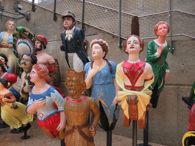
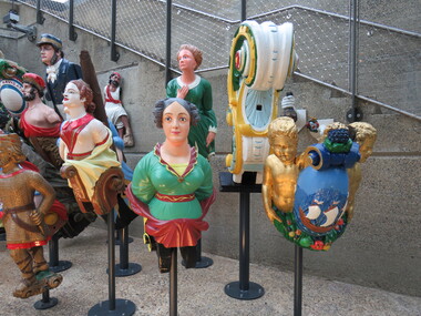
Photograph - Colour, Figureheads, Cutty Sark vessel and exhibition, Greenwich, England, 6 November 2016
... , England... bales and return to England in time for the wool sales ini...England... bales and return to England in time for the wool sales ini ...The Long John Silver Collection of Figureheads is displayed alongside the Cutty Sark. It is the largest collection of Merchant Navy figureheads in the world. It was given to Cutty Sark in 1953 by Sydney Cumbers, also known as Captain Long John Silver because of his eye patch. These figure heads come from vessels mostly dating from the 19th century and the collection, like Cutty Sark herself, is dedicated as a memorial to the men of the Merchant Navy. The Cutty Sark was launched on 22 November 1869. She was named by the wife of George Moodie, the ship's first master who had also supervised her construction. Cutty Sark left the Clyde on 13 January 1870. A month and two days later, she set sail from London for China. Cutty sark was designed and built by Scott & Linton of Dumbarton for 16,150 pounds. But much of the money was to be paid by Willis when the ship was launched. Just before they finished her, Scott & Linton ran out of money and went bankrupt. She was completed by William Denny & Brothers. The Cutty Sark was the first ship to reach London with a tea cargo in 1877. But she was one of only nine sailing ships that returned that year - in 1870 there had been 59. Steamships were now dominating the tea trade. In 1883 the Cutty Sark joined the booming trade in transporting Australian wool. Every year until 1895 she set out in the summer for Australia, to load a cargo of wool bales and return to England in time for the wool sales ini the first three months of the new year. Cutty Sark soon established herself as the fastest of the wool clippers. Under her last master, Richard Woodget she set record times of 70 days or less for the voyage which no other sailing ships could match.Colour photograph of figureheads at the Cutty Sark exhibition.cutty sark,, exhibition, wool, australia, china, sailing, woodget, moodie, london,, willis, dumbarton, scott & linton, william denny, tea, cargo, immigration, trade, figureheads -
 Ballarat Heritage Services
Photograph - Colour, Figureheads, Cutty Sark vessel and exhibition, Greenwich, England, 6 November 2016
... , England... bales and return to England in time for the wool sales ini...England... bales and return to England in time for the wool sales ini ...The Long John Silver Collection of Figureheads is displayed alongside the Cutty Sark. It is the largest collection of Merchant Navy figureheads in the world. It was given to Cutty Sark in 1953 by Sydney Cumbers, also known as Captain Long John Silver because of his eye patch. These figure heads come from vessels mostly dating from the 19th century and the collection, like Cutty Sark herself, is dedicated as a memorial to the men of the Merchant Navy. The Cutty Sark was launched on 22 November 1869. She was named by the wife of George Moodie, the ship's first master who had also supervised her construction. Cutty Sark left the Clyde on 13 January 1870. A month and two days later, she set sail from London for China. Cutty sark was designed and built by Scott & Linton of Dumbarton for 16,150 pounds. But much of the money was to be paid by Willis when the ship was launched. Just before they finished her, Scott & Linton ran out of money and went bankrupt. She was completed by William Denny & Brothers. The Cutty Sark was the first ship to reach London with a tea cargo in 1877. But she was one of only nine sailing ships that returned that year - in 1870 there had been 59. Steamships were now dominating the tea trade. In 1883 the Cutty Sark joined the booming trade in transporting Australian wool. Every year until 1895 she set out in the summer for Australia, to load a cargo of wool bales and return to England in time for the wool sales ini the first three months of the new year. Cutty Sark soon established herself as the fastest of the wool clippers. Under her last master, Richard Woodget she set record times of 70 days or less for the voyage which no other sailing ships could match.cutty sark, exhibition, wool, australia, china, sailing, woodget, moodie, london, willis, dumbarton, scott & linton, william denny, tea, cargo, immigration, trade, figureheads