Showing 25615 items matching "plenty-township-estate"
-
 Eltham District Historical Society Inc
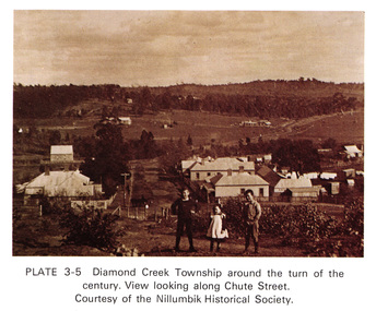
Work on paper (Sub-Item) - Photograph, View along Chute Street, Diamond Creek township, about 1901
diamond creek, chute street, view, nillumbik historical society -
 Marysville & District Historical Society
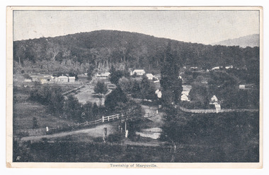
Postcard (item) - Black and white postcard, Nicholas John Caire, Township of Marysville, 1858-1918
One of a series of postcards of photographs taken by socialite photographer Nicholas John Caire. N.J. Caire had a great love for the area and in the late 1800's took many photographs of Marysville and its surrounds.One of a series of postcards of photographs taken by socialite photographer Nicholas John Caire. N.J. Caire had a great love for the area in and surrounding Marysville and in the late 1800's took many photographs of Marysville and its surrounds. N.J. Caire was born in 1837 in Guernsey. He arrived in Adelaide about 1860 along with his parents who encouraged his early interest in photography. He opened a studio in Adelaide in 1867 after traveling extensively throughout the Gippsland taking photographs. After marrying in 1870 he moved to Talbot in Victoria until 1876 when he opened a studio in the Royal Arcade in Melbourne. After 1885 N.J. Caire gave up his city work and made his home in South Yarra and devoted the rest of his life to outdoor photography, specializing in the bush, the gullies and the mountains of south-eastern Victoria. POST CARD The Address to be written on this side This space may be used for Correspondence/ within the Commonwealth at 1d. rate./ Foreign, charged ordinary letter rate. St. Fillans/ Narbethong This is the/ little village we/ visited last week/ E.L. Mrs R.D. Cole/ Mozart Villa/ Bethanga One penny Victorian postage stamp Date Stamp/ Illegible Date Stamp/ JA 16/ 6/ VICTORIA/ Illegiblemarysville, victoria, nicholas john caire, postcard, souvenir -
 Lorne Historical Society
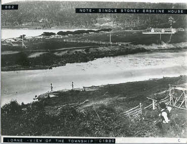
Photograph, Lorne Township circa 1880
Circa 1880. View of Lorne, Erskine River in the foreground, Erskine House is a single storey building. Men are fishing in the river, Circerskine house, lorne, circa 1880, erskine river, men fishing -
![Map, Public Lands Office, Township of Sandridge [cartographic material] / lithographed at the Public Lands Office, March 30th 1859, 30 March 1859](/media/collectors/4f729f5897f83e0308601603/items/63c6354eae7bf372478c58b7/item-media/63c635d4ae7bf372478c7627/item-fit-380x285.jpg) Mission to Seafarers Victoria
Mission to Seafarers VictoriaMap, Public Lands Office, Township of Sandridge [cartographic material] / lithographed at the Public Lands Office, March 30th 1859, 30 March 1859
The map shows where the land of the Customs House was and where the Bethel church was built in 1860. It also shows the name Gregory, a family of land owners who became the managers of the new building on the same site in 1889.sandridge, bethel church, customs house, gregory -
 Greensborough Historical Society
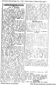
Newspaper Clipping, Greensborough. Fire in township, 11/03/1932
This article reports on the fire that destroyed the original timber Greensborough Hotel. The original hotel was built in 1860 at the corner of Grimshaw and Church Streets by Frederick Ellis. According to this article the original building was replaced in the late 1890s.2 page newspaper clipping. Downloaded from Trove.greensborough hotel, grimshaw street greensborough, church street greensborough -
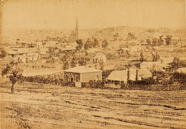
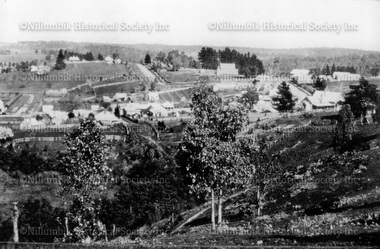
 Eltham District Historical Society Inc
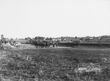
Photograph, Panoramic View of Diamond Creek Township, c.1912, 1912c
Digital copy of a framed photograph purchased at a market stall. The long low flat object behind the men and the railway wagon is probably the railway platform before the buildings were added. Digital copy of black and white photograph. (Second photo shows a detail of the first with colouring added digitally.) diamond creek -
 Eltham District Historical Society Inc
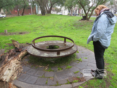
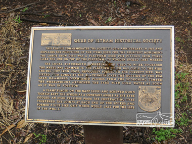
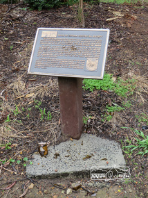
Photograph, Liz Pidgeon, Monument containing a time capsule in celebration of Victoria's 150th Anniversary and marking the location of the original centre of Eltham township, 21 June 2017, 21 June 2017
A walk around Little Eltham, 21 June 2017 Newsletter No. 175 July 2007 FORTY YEARS IN HISTORY The Society has been involved with a number of one off historical projects that have lasting outcomes. Perhaps the most significant is the monument and time capsule installed at the Eltham Community Centre site at the comer of Pitt Street and Main Road to commemorate Victoria's 150th anniversary. The monument based on a blacksmith's tyring plate was designed by artist Joh Ebeli. Beneath it is a time capsule containing items from 1985 and donated by Graham Beyer. It is to be opened in 2035.Born Digitalmain road, time capsule, monuments -
 Eltham District Historical Society Inc
Photograph, Liz Pidgeon, Monument containing a time capsule in celebration of Victoria's 150th Anniversary and marking the location of the original centre of Eltham township, 21 June 2017, 21 June 2017
A walk around Little Eltham, 21 June 2017 Newsletter No. 175 July 2007 FORTY YEARS IN HISTORY The Society has been involved with a number of one off historical projects that have lasting outcomes. Perhaps the most significant is the monument and time capsule installed at the Eltham Community Centre site at the comer of Pitt Street and Main Road to commemorate Victoria's 150th anniversary. The monument based on a blacksmith's tyring plate was designed by artist Joh Ebeli. Beneath it is a time capsule containing items from 1985 and donated by Graham Beyer. It is to be opened in 2035.Born Digitalmain road, time capsule, monuments -
 Kiewa Valley Historical Society
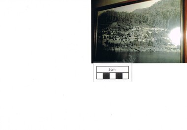
Photograph Bogong, Bogong Township Circa 1950, circa 1940s to 1950s
The Bogong Village was originally constructed (1937-1940) by the State Electricity Commission to house, engineers and construction workers working on the Kiewa Hydroelectric Scheme. These workers were initially settled in 26 houses and were mainly of European heritage. At the completion of the scheme, in the 1960's, the village was opened to public/tourism use. This photograph shows the village before beautification for tourism was introduced and "bare bones" homes and village usage existed.This photo clearly presents a period of restricted human occupation of a very fragile Alpine environment(up to 4000 workmen involved). This was the beginning of a planned and controlled form of sustainable tourist orientated development of the Victorian Alps and high plains region. The Bogong Township was the base camp for workers employed by the State Electricity Commission. After the construction phase was completed, the planning and controls originating from this period have been modified to allow a greater public access of this unique environment.Photograph of a framed glass enclosed black and white photograph of the Bogong settlement Paper details "KodakXtraLife paper" on back of photo. bogong village, bogong township, sec alpine constructions, hydro, kiewa scheme -
 Eltham District Historical Society Inc
Photograph, Main Road, Eltham Township, 1930c
Postcard showing Main Road, Eltham near present Pryor Street including boot repair shop (Frank Mcdonald) and Blue Gum Milk Bar (Jim Burges) c.1930eltham, main road, shops, pryor street, blue gum, burges, frank mcdonald -
 Eltham District Historical Society Inc
Photograph postcard, Diamond Creek Township, c.1913
Digital file only Postcards scanned from the collection of Michael Aitken on loan to EDHS, 13 Feb 2018michael aitken collection, postcards, diamond creek -
 Poowong Historical Group
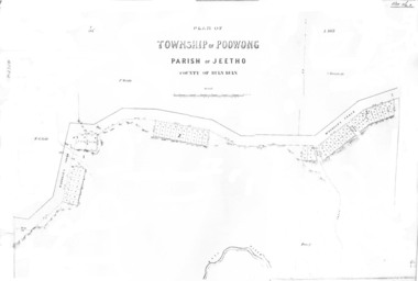
Poowong Township Map 1
Photocopy of original map - fair quality41584 pencilled on top left corner -
Federation University Historical Collection
Artwork - Print, 'Ballaarat Post Office & Township from Government Enclosure' by S.T.Gill
Verso on sticker bottom right 'S.T. Gill Print/ Steel Engraving by Tingle/ from Victoria Illustrated/ Melbourne 1857/Penn's Book Shop/ 123 Lt Collins St Mel/ 63 5134s.t.gill, print -
 Federation University Historical Collection
Document - Report, Township of Maldon Tourism Development Strategy, 1992, 18/06/1992
Report compiled by four students of Tourism at Ballarat University College (later Federation University Australia)victorian tourisim industry, tourism, victorian goldfields, maldon, built heritage, national trust -
 Kinglake Historical Society
Kinglake West township
Kinglake West corner with post office (formerly Tommys Hut) and Carman's garage on left. In the days of dirt roads.Early photograph of intersectionPhotograph of Kinglake West corner with the post office on the right and Carman's shop and garage on the left.post office, kinglake west, tommys hut, carman -
Port Melbourne Historical & Preservation Society
Plan - Sandridge, Department of Lands and Survey, "The Township of Sandridge", 5 Nov 1860
Map of Sandridge, lithographed 1860, showing subdivisions on Evans Street, but no other development West of the railway Lihographed at the Department of lands and Survey, Melbourne 5th November 1860. Hand drawn annotations added at unknown date.Hand written "clay ground" 18 chains long, 7.5 chains broad, 26 chains from railwayengineering - roads streets lanes and footpaths, sandridge lagoon, transport - railways, town planning, local government - borough of sandridge -
 Bendigo Art Gallery
Photograph - Work on paper, Nicholas CAIRE, View of the Golden Square Township, 1875
l.l; N.J.Caireaustralian photographer, albumen, bendigo, golden square, sandhurst, town, city, skyline -
 Bendigo Art Gallery
Photograph - Work on paper, Nicholas CAIRE, Township of Eaglehawk, 1875
Inscribed on original mountcard, l.l., gold letterpress, "N.J. CAIRE"eaglehawk, albumen, photograph, regional victorian. civic, roads, town, bendigo, sandhurst -
Tatura Irrigation & Wartime Camps Museum
Booklet, Kyabram The Larger Valley Township, 1989
Presented by author to Tatura Historical SocietyYellow soft cardboard cover with brown printed titletown of kyabram, books, history, local -
Tatura Irrigation & Wartime Camps Museum
Booklet, Kyabram - The Larger Valley Township, 1989
Covering the history of Kyabram from the early settlement, railways and businesses and Kyabram CanneryBeige cover, brown writing. Swirls of brown top and bottom of frontcoverkyabram early settlement, railways, kyabram businesses, kyabram cannery, tatura, books, history, local -
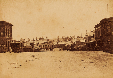
 Lake Bolac & District Historical Society
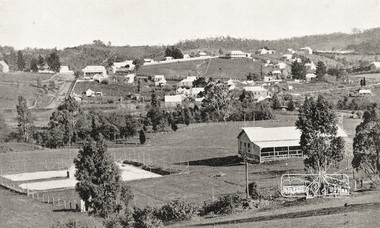
Colour photograph, Lake Bolac township. 1963
Crossroads at Lake Bolac, 1963. Junction of the Ballarat/Hamilton and Ararat/Mortlake roads. Starting centre left, the large building on the south-east side of the Ballarat road is Goodall's garage. Next door is the original Bush Nursing centre, then Dalgety's, the Bakery, the Milkbar and on the corner is the Bank of New South Wales building, Elder's, Green's drapery shop and the Lake Bolac Memorial Hall. On the traffic island in front of the Hall is the War Memorial and across the Woorndoo road is the Hotel (with the maroon roof) with stables behind. Across the road again is the Stanbury's General Store with their large warehouse behind.lake bolac, 1963, goodall, bush nursing, dalgety, elders, green, bank of new south wales, stanbury. -
 Inverloch Historical Society
000450 Postcard - Scene of Outrim mine and township, Victoria - Should be Outtrim - Photocards by SGP Wonthaggi 5672 1749
-
 Inverloch Historical Society
000453 Postcard - Township Outrim, Victoria - Should be Outtrim - Photocards by SGP Wonthaggi 5672 1749
-
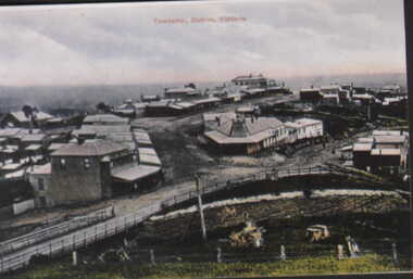
 Nillumbik Historical Society Incorporated
Photograph - Black & white photograph, Diamond Creek township panorama from Fraser Street 1944
-
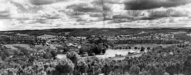
 Nillumbik Historical Society Incorporated
Photograph - Black & white photograph, Diamond Creek township from Fraser Street c1900
Black & white photographdiamond creek, view from fraser street, nillumbik -
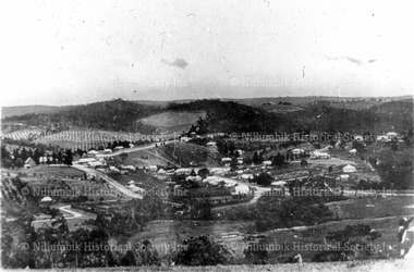
 Nillumbik Historical Society Incorporated
Photograph - Black & white photograph, Diamond Creek township from Ness Street c1900
-
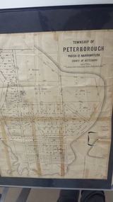 Peterborough History Group
Map - Map of the township of Peterborough, Township of Peterborough
Undated but indicative of the layout of the town. includes printed notes regarding the landscape and flora.Old map of the township of Peterborough from J S Irvine.A3 size paper map with tape around the sides. Includes handwritten notes.Handwritten on the rear is J.S Irvinepeterborough, old maps -
Stawell Historical Society Inc
Map, Stawell Gold Mines, Plan View of Township Area Showing Known Old Workings. 2003, 13/06/2003
Two AO Maps that Overlap Showing Old workings on Map of Town North of Patrick StreetScale 1 : 5000