Showing 1845 items matching "rivers in victoria"
-
 Lakes Entrance Historical Society
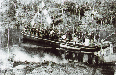
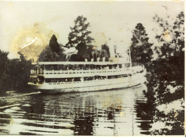
Photograph - S.S. Tambo, 1885 c
Black and white photograph showing S S Tambo, trail trip 1882 on Tambo River shows large crowd on boat, bunting flying from mast, two small row boats either side. Thick bush on far bank. Post and rail fence going into the water lower right hand corner. Camp oven or boiler and camp fire lower left hand corner. Tambo Upper Victoriaboats and boating, tourism, waterways -
 Lakes Entrance Historical Society
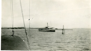
Photograph - S.S. Gippsland, 1933
Second copy shows rear view of grounded boat.Black and white photograph showing S S Gippsland aground in Lake King at mouth of Mitchell River, taken from another boat. Lakes Entrance Victoria waterways, ships and shipping, shipwrecks -
 Lakes Entrance Historical Society
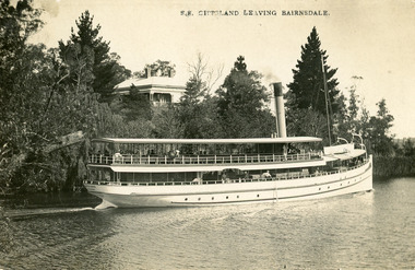
Postcard - S.S. Gippsland, Segerberg and Bulmer, 1909
S S Gippsland was launched at Paynesville 1908. Letter on back mentioning 'Our New Boat'Black and white postcard print showing S S Gippsland in Mitchell river at Bairnsdale, shows three pine trees, large house vegetation on eastern bank, ship leaving Bairnsdale newly painted. Lakes Entrance VictoriaS.S. Gippsland Leaving Bairnsdalevegetation, waterways, ships and shipping, houses -
 Lakes Entrance Historical Society
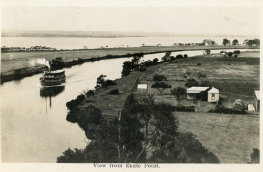
Postcard - Eagle Point, 1930 c
Black and white postcard S S Gippsland in Mitchell River, travelling towards Bairnsdale, silt jetties extending eastwards small farm, farm house and sheds on right. Jones bay in Middle distance beyond silt jetty, taken from Eagle Point Bluff. Bairnsdale VictoriaView from Eagle Point. ships and shipping, waterways, agriculture, houses -
 Lakes Entrance Historical Society
Photograph - S.S. Gippsland, 1910 c
Black and white photograph showing the S S Gippsland in Mitchell river, near Bairnsdale, shows three pine trees, other vegetation and a building on far bank, reflections in river,people on board, hull painted white, similar to a Bulmer postcard showing ship leaving Bairnsdale. Bairnsdale Victoria ships and shipping, waterways -
 Lakes Entrance Historical Society
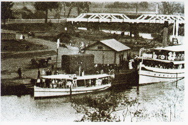
Photograph - Lady Harriet, 1912 c
Black and white photograph showing steamer Lady Harriet on left, S S Gippsland on right at Bairnsdale wharf on Mitchell River, railway track behind Lady Harriet, horse and jinker at wharf, shed at wharf, road bridge over river with people in background. Bairnsdale Victoriaships and shipping, boats and boating, wharfs -
 Lakes Entrance Historical Society
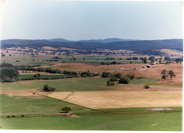
Photograph - Mossiface Flats, Tambo Shire, 1994
Also second identical copyColour photograph of the Mossiface Flats, near Bruthen, shows paddocks of the rich river flats, timbered foothills in the distance, with mountain range behind. Some paddocks have been mown for grass hay. Farm buildings in foreground and background. Dam in foreground. Bruthen Victoriaanimals, agriculture, vegetation, topography -
 Lakes Entrance Historical Society
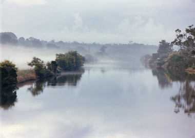
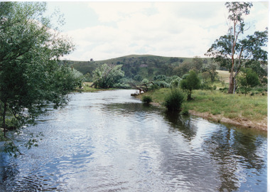
Photograph, 1994
Also second identical copyColour photograph of the Tambo River, showing mist over the river and banks either side. Swan Reach Victoria vegetation, topography, waterways -
 Lakes Entrance Historical Society
Photograph - Buchan River, Tambo Shire, 1994 c
... . Buchan Victoria Photograph Buchan River Tambo Shire ...Colour photograph of the Buchan river, showing stream flowing between low banks, hills rising in distance. Buchan Victoria topography, waterways -
 Lakes Entrance Historical Society
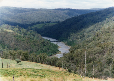
Photograph - Snowy River, Tambo Shire, 1994
... and into the far distance. Buchan Victoria Photograph Snowy River Tambo ...Also second identical copyColour photograph of the Snowy River near The Basin, showing a river flowing between rocky banks, densely forested hills rising on both sides and into the far distance. Buchan Victoria topography, waterways -
 Greensborough Historical Society
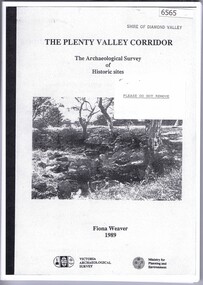
Book, The Plenty Valley Corridor: the archaelogical survey of historic sites, by Fiona Weaver, for the Ministry of Planning & Environment, 1989_
The Victorian Archaelogical Survey managed this study onbehalf of the Ministry for Planning & Environment. The study was intended to provide a brief history of Aboriginal and European occupation and use of the area and an outline of the geography of the chief areas of cultural heritage concern, with recommendations for protection of significant cultural sites and recommendations for further research, survey and consultation.115 p., photocopy, unbound. Illus., mapsplenty river, fiona weaver, victorian archaeological survey -
 Greensborough Historical Society
Newspaper - Newspaper Clipping - Digital Image, Diamond Valley News, Archaeological sites in corridor to be surveyed, 1990c
... by Ellender and Weaver. plenty valley plenty river victoria ...An undated newspaper article announcing an archaeological survey of the Plenty Valley corridor to be undertaken by Isabel Ellender and Fiona Weaver. The findings were published separately by Ellender and Weaver.Digital copy of newspaper articleplenty valley, plenty river, victoria archaeology, victorian archaeological survey, isabel ellender, fiona weaver -
 Lakes Entrance Historical Society
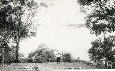
Postcard - The Entrance, Bulmer H D, 1910c
Also black and white enlargement size 16 x 25.| Note on back of postcard, 'Bemm River 16/8/11, To My Dear Elsie, Just a line....., Much love from all, Annie.'Black and white postcard of the man made entrance through the sand hummocks, taken from Jemmys Point. Small boy looking towards entrance, natural vegetation on brow of hill. Lakes Entrance VictoriaLakes Entrance waterways, topography -
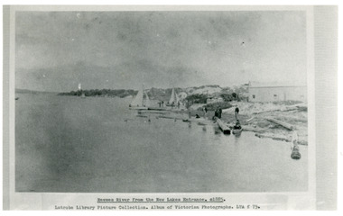 Lakes Entrance Historical Society
Photograph - Reeves River
... entrance. Lakes Entrance Victoria Photograph Reeves River ...Black and white photograph showing building, boats, and workmen at site of proposed New Entrance. View of Reeves River, later called Cunninghame Arm, looking east towards natural entrance. Lakes Entrance VictoriaReeves River from the New Lakes Entrance 1885c waterways, public works -
 Bacchus Marsh & District Historical Society
Map, O'Hagan v Shire of Bacchus Marsh, Allotment 5, Sec 16, Parish of Korkuperrimul
The purpose for this map being created or the date when it was made has not been established. It appears to be documentation relating to a legal dispute by a landowner named O'Hagan and the Shire of Bacchus Marsh. Features identified on the map are allotment 5, section 16, Parish of Korkuperrimul, a 'cultivation paddock', a section of the Werribee River, the path of a section of a 'Main Channel', and a barrier or filled in section across the Werribee River called 'Lee's Filling'. The O'Hagan is likely to be Patrick O'Hagan, 1829-1914 who arrived in Bacchus Marsh in 1864 and was a prominent citizen and landowner in the area for many years until his death in 1914.Single page map showing allotment 5, section 16 in the Parish of Korkuperrimul, Scale 4 chains to inch. Part of a set of maps which are pasted into a bound volume containing 76 maps or plans in total. High resolution digital image stored on BMDHS computer network. Stamped: Munzt, Bace and Muntz, Civil Engineers and Licensed Surveyors , 388 Collins Streetbacchus marsh victoria maps, water supply structures and establishments, watercourses -
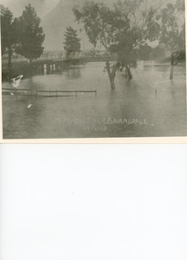 Lakes Entrance Historical Society
Photograph - Floods, 1919
Black and white photograph showing Mitchell River in flood at the old highway bridge at east end of town. Roof of Imperial Hotel in background at far end of bridge, trees and fences under water in foreground. Bairnsdale Victoriabridges, flooding -
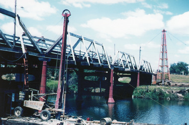 Lakes Entrance Historical Society
Photograph - Bridges, Scarce, Keith, 1955
Colour photograph of the W L Sides and Son drilling rig beside the bridge over the Mitchell River, testing for foundations for the planned new bridge. Bairnsdale Victoriabridges, waterways, machinery -
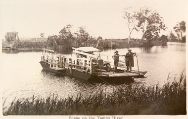 Lakes Entrance Historical Society
Photograph - Johnsonville Punt, 1930
Also black and white copy 16.5 x 25 donatedBlack and white photograph of a postcard of the punt, two men and early model motor vehicle on punt. Johnsonville, Victoria.Scene on the Tambo River waterways, transport -
 Lakes Entrance Historical Society
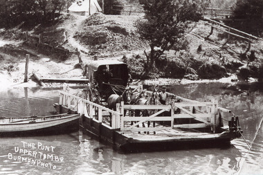
Photograph - Upper Tambo Punt, Burman A W, 1905
Black and white photograph of the punt over the Tambo River showing the punt man standing beside a buggy with hood up drawn by three horses, driver seated in buggy. Upper Tambo Victoria, waterways, transport -
 Lakes Entrance Historical Society
Book, Smyth Chris, Baltuiks Isabel, Roberts Lorelle, Roberts Maurice, Stooping Stones a Guide to Mallacoota and District, 1986
Description guide to Mallacoota Victoria and the surrounding district of far East Gippsland including Genoa Gipsy Point and Betka River illustrated with sketch maps photographs and sketches.township -
 Lakes Entrance Historical Society
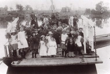
Photograph - Johnsonville Punt, 1921
Black and white photograph of the Johnsonville State School students posed on the Johnsonville Punt moored to the bank of the Tambo River. Many of the children are holding bunches of greenery, perhaps, indicating Arbor Day. Some adults also present. Johnsonville Victoria waterways, schools, transport -
 Bacchus Marsh & District Historical Society
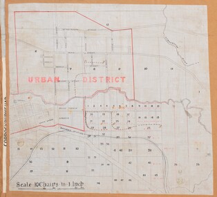
Map, Bacchus Marsh Urban District
The date of this map has not been established but the date would be sometime after 1887 as the Bacchus Marsh Railway Station, which opened in 1887, is shown on the map. A single page paper map showing blocks of land in the urban district of Bacchus Marsh. The 'urban district' is indicated by red drawn lines on the map and includes streets and blocks on the northern side of the Werribee River in Bacchus Marsh, and streets and blocks south of the Werribee in Maddingley. Scale 10 chains to 1 inch. The map is pasted into a bound volume containing 76 maps or plans in total. High resolution digital image stored on BMDHS computer network. bacchus marsh victoria maps, maddingley victoria maps -
Lakes Entrance Historical Society
Book, Rogers L C, My Journey from the Snowy River, 1982
Reminiscences of life in remote areas of Victoria at the turn of the Century by a son of a pioneering family of the Black Mountain in East Gippsland.settlers -
 University of Melbourne, Burnley Campus Archives
Plan, Horticultural Society of Victoria Plan of Gardens, Richmond, 1865
Plan on linen-backed paper of Burnley Gardens showing Yarra River, Swan St., railway, plan of west orchard and old garden sketched by hand in pencil. Inscription, "Presented to the Society, by A. Purchas C.E." Shows acreagesInscription, "Presented to the Society, by A. Purchas C.E." Oct 4th 1865"gardens, richmond, a. purchas, horticultural society of victoria -
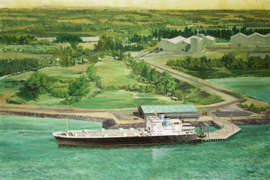 Mission to Seafarers Victoria
Painting - Painting, Acrylic, Ramon Honisett, Untitled, 1990-2000
Ramon (Ray) Francis Honisett (11.04.1931 - 30.08.2019), Fellow RMIT and medallist specialised in philatelic design, marine and military aircraft painting art and was active in the 1960s - 1990s. Ray Honisett used to live in Rye, in the Mornington Peninsula. According to Gavin Fry's book: The painting likely depicts the Lysaght Endeavour loading at Hastings. "The Lysaght Endeavour and its sister ship Lysaght Entreprise were built in Newcastle in 1973 specifically to serve the regional steel industry on the route Port Kembla - Westernport - Adelaide. Even after being lengthened by 17 metres, the two ships had remarkably short working lines, with both being broken up by 1988."Maritime artLarge framed unglazed landscape format painting predominantly green depicting in foreground a merchant vessel, a roll-on roll-off cargo ship moored at a single quayside on a river or river mouth. The middle ground shows a moderate solid jetty leading to large storage sheds at right. The background appears primarily rural with fields and hills in the distance. The location is probably Hastings Western Port in Victoria - notice the forklifts loading rolls of steel produced at the nearby steel rolling mill - the buildings in the distance. You can see the rolls of steel lined up on the hard stand to the right of the ship. The funnel colours suggest the Australian National Line. The frame incorporates a beige fabric slip with gilt edge the actual dark wood frame also with inset banded gilt edge. The back of the painting is covered with brown paper in places damaged. Hangs on a cotton cord threaded between two screw in eyelet hooks.at lower right corner single uc word in black paint : "HONISETT"tankers, marine painting, maritime art, ramon honisett, ray honisett, anl maritime art prize, acta maritime art prize, hastings, western port, victoria, steel, roll on roll off, forklift, mornington peninsula, artwork-paintings -
 Bacchus Marsh & District Historical Society
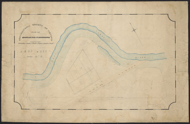
Map, Maddingley Township, Parish of Parwan, 1880s
This map is dated Sept. 6th 1856. However places in the township of Maddingley which did not appear until the late 1880s such as the Bacchus Marsh Railway Station and line are shown on this map in their correct locations. This suggests the map has been derived from an earlier map. An earlier date of 1843 with a surveyor's name preceding it can also be seen on the map. The map is important because it indicates the location and dimensions of early but now discontinued use of land such as the showgrounds and police paddock and a site reserved for the Church of England which was not ultimately used for a permanent church. A single page paper map showing land allotments, streets, rivers, creeks, park lands, the railway line and Bacchus Marsh railway station in the township of Maddingley. The map is pasted into a bound volume containing 76 maps or plans in total. Bottom of Map: Surveyor-General's Office, Melbourne, Sept 6th, 1856bacchus marsh victoria maps, maddingley victoria maps, land use, maddingley victoria history -
 Wodonga & District Historical Society Inc
Photograph - First Presbyterian Church, Wodonga
Members of the Presbyterian faith were among the first settlers in the North-east of Victoria, and in the year 1842 the Presbytery of Melbourne requested the Rev. Peter Gunn, Minister of the Gaelic Church, Melbourne, to visit Presbyterians along the Murray River. This was the first of a series of annual visits, and was of a missionary nature. In May 1851, the Rev. David Hunter Ballantyne was appointed to the Wodonga district based out of Albury. In 1860 the Presbytery of Beechworth was formed, and from it two large presbyteries have grown - Wagga Wagga and Beechworth. In the early days the services at Wodonga were held in the old court house, which still stands. Wodonga Presbyterian Church continued as part of the Parish of Albury until the end of 1887, when it was placed under the administration of the Session of the Beechworth Church, with a home missionary in charge. Mr William Cooper was placed in charge for the first months, then Mr William Smith, a city missionary who had recently arrived from Scotland, was appointed. Mr Smith conducted a cordage factory at Stonleigh. He remained as missionary in charge for the next 10 years, and in that time the church steadily progressed. Plans were made for the erection of the building which now stands in High Street, Wodonga. Mr John Whan was a Founding Member of the Church and was appointed Sunday School Superintendent, an office which he held for 46 years, rendering extensive and valued service to the church and congregation. With a growing congregation and realising the challenges presented to the Church by changing conditions, land for a new church was sought. In September 1950 property was purchased in Nilmar Avenue in Wodonga and the new Presbyterian Church St Stephens became their new home. With the amalgamation of the Presbyterian and Methodist Churches, the new Church became the Uniting Church. The original Presbyterian Church was later sold to the Free Serbian Orthodox Church.These photographs are significant because they provide evidence of the changing nature of religious worship and groups in Wodonga.A collection of black and white photographic images depicting the first Presbyterian Church at Wodonga. The Church was later taken over by the Free Serbian Orthodox Church.presbyterian church, free serbian orthodox church, wodonga churches -
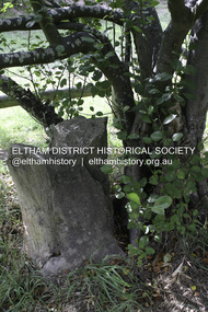 Eltham District Historical Society Inc
Photograph - Digital Photograph, Alan King, Heritage apple tree, 24 January 2008
This old apple tree situated beside the Plenty River Trail at Greensborough has been associated with Melbourne Founder John Batman. The concrete block is inscribed with the date 1841, when the tree was thought to have been planted. Known as Batman's Tree, this apple tree is on the bank of the Plenty River near Leischa Court, Greensborough. It is said that Melbourne Founder John Batman may have planted the tree and later signed his treaty here with the Aboriginal people. It still bears fruit and its recorded on the National Trust's Register of Significant Trees, as the oldest apple tree in Victoria. Published: Nillumbik Now and Then / Marguerite Marshall 2008; photographs Alan King with Marguerite Marshall.; p7This collection of almost 130 photos about places and people within the Shire of Nillumbik, an urban and rural municipality in Melbourne's north, contributes to an understanding of the history of the Shire. Published in 2008 immediately prior to the Black Saturday bushfires of February 7, 2009, it documents sites that were impacted, and in some cases destroyed by the fires. It includes photographs taken especially for the publication, creating a unique time capsule representing the Shire in the early 21st century. It remains the most recent comprehenesive publication devoted to the Shire's history connecting local residents to the past. nillumbik now and then (marshall-king) collection, greensborough, john batman tree, plenty river trail -
 Eltham District Historical Society Inc
Photograph - Digital Photograph, Alan King, Heritage apple tree, 24 January 2008
This old apple tree situated beside the Plenty River Trail at Greensborough has been associated with Melbourne Founder John Batman. Known as Batman's Tree, this apple tree is on the bank of the Plenty River near Leischa Court, Greensborough. It is said that Melbourne Founder John Batman may have planted the tree and later signed his treaty here with the Aboriginal people. It still bears fruit and its recorded on the National Trust's Register of Significant Trees, as the oldest apple tree in Victoria. Published: Nillumbik Now and Then / Marguerite Marshall 2008; photographs Alan King with Marguerite Marshall.; p7 Was This John Batman's Tree? An apple tree on the bank of the Plenty River near Leischa Court, Greensborough, is believed to have belonged to Melbourne’s founder, John Batman. It could also stand where John Batman signed his famous treaty with the Aboriginal people.1 Known as Batman’s Tree, it still bears fruit and is recorded on the National Trust’s Register of Significant Trees, as the oldest apple tree in Victoria. It is ‘Believed to have been planted by either John Batman, (c1837) or Martin Batey (1841)’.2 In 1966 a Horticultural Adviser, Mr Rolfe, after extensive questioning of aged Greensborough residents, wrote: ‘it thus seems fairly certain that the old tree on the banks of the Plenty River is an original Batman apple tree’. Mr Rolfe said that the tree stood on a spot formerly called Wattle Bend: ‘one of the sites claimed to be where John Batman signed his famous treaty with the aboriginals. ‘My main source of information has been interviews with people who attended school in the Greensborough area from 70 to 80 years ago. Their parents were close to the days when Melbourne was founded so information passed on by word of mouth.’ Around 1920 the tree was struck by lightning and a concrete block was placed in the split. The concrete is inscribed with the date 1841 when the tree was thought to have been planted. Not everyone agrees with Mr Rolfe however. Former secretary of the Nillumbik Historical Society, Kevin Patterson, said there was no written evidence to support the claim. But he said the tree had been known to locals for decades as Batman’s Tree. In the 1920s a holiday resort in the area advertised: ‘Come to Greensborough and see John Batman’s tree’. Mr Patterson said it was thought that when Batman died in 1839 his land was sold and a Greensborough man Frederick Flintoff bought seedlings from his orchard for £1 each. This was the only one left.3 Mr Rolfe said: ‘If planted in 1837, or even a few years later, it undoubtedly is the oldest living apple tree in Victoria. Title records of the property on which the tree grows show that the land was a crown grant of F D Wickham in 1840. Mr Wickham was reputed to be a friend of John Batman. All the early settlers prior to the crown grants were squatters, by virtue of Batman’s treaty. This treaty was revoked by the then New South Wales Government, so it is likely that Wickham or an agent was in occupation before 1840. ‘According to Mrs Mavis Latham (John Batman – Great Australian Series, Oxford University Press) when Batman came to Port Phillip in 1835 he brought fruit trees with him. He failed to get a crown grant for his selection on Collins Street, which included 20 acres (eight ha) of orchard and cultivation. His residence became the Government Office and Melbourne grew from wild bushland in 1835 to a town of over 20,000 people by 1841. It is possible Batman visited Wickham and presented him with a tree.’ However a Flintoff descendant in 1933 said Frederick Flintoff ordered his bailiff Martin Batey to transplant the Batman Tree from the Spencer Street orchard to its present site as a memorial to his friend Batman.4 Mr Rolfe spoke to many people, including descendants of the Bateys and Flintoffs and pupils at the Greensborough Primary School. Many had gained their information from a ‘very highly respected’ head master Lewis Amiet at the Greensborough School from 1895 to 1917. He must have gained this information from residents in the district and had this information been incorrect, the parents of the children would have promptly corrected him.’ One woman who attended the school before Mr Amiet’s appointment, said the previous teacher also taught that the tree on the Plenty River was a Batman tree, Mr Rolfe said.This collection of almost 130 photos about places and people within the Shire of Nillumbik, an urban and rural municipality in Melbourne's north, contributes to an understanding of the history of the Shire. Published in 2008 immediately prior to the Black Saturday bushfires of February 7, 2009, it documents sites that were impacted, and in some cases destroyed by the fires. It includes photographs taken especially for the publication, creating a unique time capsule representing the Shire in the early 21st century. It remains the most recent comprehenesive publication devoted to the Shire's history connecting local residents to the past. nillumbik now and then (marshall-king) collection, greensborough, john batman tree, plenty river trail -
 Eltham District Historical Society Inc
Photograph - Digital Photograph, Marguerite Marshall, 'Worlingworth', 10-26 Banoon Road, Eltham, 30 January 2006
'Worlingworth', Eltham, home of noted anthropologist the late Professor Donald Thomson and his wife Dorita Thomson. Covered under Heritage Overlay, Nillumbik Planning Scheme. Published: Nillumbik Now and Then / Marguerite Marshall 2008; photographs Alan King with Marguerite Marshall.; p127 Dubbed as ‘Australia’s Lawrence of Arabia’ anthropologist Donald Thomson lived much of his life in Eltham, at Banoon Road. On his retirement as Professor of Anthropology in 1968, The University of Melbourne professorial board compared Thomson to Lawrence of Arabia because of his work for Aborigines and his controversial personality. Although Thomson is now recognised for his huge contribution, during his lifetime he suffered opposition and his life has been described as ‘tragic’.1 Thomson failed to gain the recognition as a scientist that he felt he deserved and he failed to alter government policy towards Aboriginal people. But towards the end of his life in 1970, anthropologists were moving towards the type of research he had done and the movement to grant land rights to Aborigines was strengthening. Thomson is best known for his anthropological fieldwork in Cape York, Arnhem Land and Central Australia, but he is also known for his scholarly contributions to ornithology and ecology. Thomson documented every aspect of the daily and ritual life of the Aboriginal world of Cape York and Arnhem Land in the 1930s and 1940s. The huge collection in Museum Victoria includes 11,000 photographs, 7500 items of material culture, 1000 botanical and zoological specimens and 4500 pages of field-notes.2 The film Ten Canoes used Thomson’s photographs as a source. Thomson bought the Eltham property known as Worlingworth in 1934. The single-storey 60-square house standing by the Yarra River was built in 1922-23. It is one of the last in Eltham to survive with its farm setting intact. It is also one of the few substantial residences built in the Eltham Shire from the late 19th century to the early 20th century, which signalled a major change in the area towards the residential municipality it is today.3 The original section, built in the mid 1860s, of rose pink hand-made bricks and stone quarried on the property, was incorporated in the new red-brick house built in 1922. An immense oak tree by the house grew from an acorn brought by Patrick Armstrong who first bought the land in March 14, 1862. Armstrong named Worlingworth after his forbears’ village in Suffolk, England. Worlingworth saw grand days when Commander Alan A Barlee (R.N.) bought it in 1922 after winning the Calcutta Sweep. The property then included a nine-hole golf course, a tennis court, a bowling green, a boathouse and a boat-ramp.4 For most of his career Thomson, who was born in 1901, was attached to The University of Melbourne. In 1935 he represented the Commonwealth Government at Caledon Bay in east Arnhem Land to investigate and mediate for four Aborigines accused of killing five Japanese and three Europeans. In 1938 Thomson was awarded a PhD in Anthropology at Cambridge University, and during his career, he received several medals from British Societies, who perhaps appreciated his work better than their Australian counterparts. From World War Two, Thomson suffered a string of hardships, beginning with severe wounding in Dutch New Guinea (for his military service in New Guinea he was awarded an OBE) and he was invalided from service in 1944. That year he was diagnosed with diabetes. A fire in 1946 destroyed what Thomson regarded as perhaps the best record he had made of Aboriginal life – the 20,000 feet, (6096m) of film he had shot in Arnhem Land. In 1954 he and wife, Gladys, divorced. The next year he married his technical assistant, Dorita McColl. Several times during his career Thomson had major disagreements. For instance Professor P Elkin constantly opposed his work. He also opposed Thomson when he campaigned vigorously in 1947 against the establishment of a rocket range at Woomera, South Australia, because of the threat it posed Aborigines. Thomson resigned in frustration from the Victorian Aborigines Welfare Board in 1967, after serving for ten years, because he found that his advice was disregarded. His ashes were scattered over Caledon Bay from the air.This collection of almost 130 photos about places and people within the Shire of Nillumbik, an urban and rural municipality in Melbourne's north, contributes to an understanding of the history of the Shire. Published in 2008 immediately prior to the Black Saturday bushfires of February 7, 2009, it documents sites that were impacted, and in some cases destroyed by the fires. It includes photographs taken especially for the publication, creating a unique time capsule representing the Shire in the early 21st century. It remains the most recent comprehenesive publication devoted to the Shire's history connecting local residents to the past. nillumbik now and then (marshall-king) collection, banoon road, donald thomson, dorita thomson, eltham, worlingworth