Showing 3734 items
matching street map
-
 Bendigo Historical Society Inc.
Map - HAWKESTONE : COUNTY OF BENDIGO, December 1953
... Inc. History House 11 Mackenzie Street Bendigo goldfields MAP ...Map. Hawkestone, County of Bendigo, County of Talbot, Sutton Grange, Redesdale, Faraday, Elphinstone, Metcalfe, Coliban River. By authority W.M. Houston, Government Printer. Drawn and reproduced at the Department of Lands and Survey, Melbourne. December 1953. Price 5/-. (number 97 in map cupboard 1)W.M. Houston, Government Printer.map, bendigo, hawkestone. -
Bendigo Historical Society Inc.
Map - HARCOURT : COUNTY OF BENDIGO, December 1951
... Inc. History House 11 Mackenzie Street Bendigo goldfields MAP ...Map. Harcourt, County of Bendigo, County of Talbot, Ravenswood. Sutton Grange, Walmer, Castlemaine, Faraday, Calder Highway, Northern Railway, Town of Harcourt, Barkers Creek, Victorian Water Supply Res., in connection with Barkers Creek Reservoir. By authority J.J. Gourley, Government Printer, Melbourne .Drawn and reproduced at the Department of Lands and Survey, Melbourne. December 1951. Price 2/- per sheet. (number 96 in map cupboard 1)J.J. Gourley, Government Printer, Melbourne.map, bendigo, harcourt -
Bendigo Historical Society Inc.
Map - HARCOURT, December 1951
... Inc. History House 11 Mackenzie Street Bendigo goldfields MAP ...Harcourt, County of Bendigo, Walmer, Castlemaine, Sutton Grange. Mt.Alexander Trig. Station, Barkers Creek, Faraday, Calder Highway, Northern Railway. By Authority J.J.Gourley, Government Printer, Melbourne,Drawn and Reproduced at the Dept. of Lands and Survey, Melbourne, Victoria. December 1951. Price 5/-per sheet. (number 35 in map cupboard 1)J.J.Gourley, Government Printer, Melbourne.map, bendigo, harcourt -
Bendigo Historical Society Inc.
Map - SALISBURY WEST : COUNTY OF BENDIGO, 3-3-1944
... Inc. History House 11 Mackenzie Street Bendigo goldfields MAP ...Map. Salisbury, County of Bendigo, County of Gladstone, Powlett, Yarrayne, Bridgewater, Inglewood, River Loddon, Bullabul Creek, Glenalbyn, Kurting. By Authority H.E. Daw, Government Printer, Melbourne. Drawn and reproduced at the Department of Lands and Survey, Melbourne., 3-3-1944. Price 5/-. (number 94 in map cupboard 1)H.E. Daw, Government Printer, Melbourne.map, bendigo, salisbury west -
Bendigo Historical Society Inc.
Map - COSTERFIELD : COUNTY OF BENDIGO, 31-10-12
... Inc. History House 11 Mackenzie Street Bendigo goldfields MAP ...Map. Costerfield, County of Bendigo, County of Dalhousie, Dargile, Moorambool West, Warrowitue, Heathcote, Town of Costerfield. Photo-Lithographed at the Department of Lands and Survey, Melbourne, by W.J .Butson 31-10-12 price 1/-. (number 93 in map cupboard 1)W.J. Butsonmap, bendigo, costerfield -
Bendigo Historical Society Inc.
Map - COSTERFIELD : COUNTY OF BENDIGO, 29-10-29
... Inc. History House 11 Mackenzie Street Bendigo goldfields MAP ...Map. Costerfield, County of Bendigo, Counties of Dalhousie & Rodney, Dargile, Moormbool West, Warrowitue, Heathcote, Town of Costerfield, Dalhousie. By Authority H.J. Green, Government Printer, Melbourne. Drawn and reproduced at the Department of Lands and Survey, Melbourne. 29-10-29. Price 2/-. (number 92 in map cupboard 1)H.J. Green, Government Printer, Melbourne.map, bendigo, costerfield -
Bendigo Historical Society Inc.
Map - HEATHCOTE : COUNTY OF BENDIGO
... Inc. History House 11 Mackenzie Street Bendigo goldfields MAP ...Map. Heathcote, County of Bendigo, County of Dalhousie, Knowsley, Knowsley East, Dargile, Costerfield, Warrowitue, Tooborac, Langwornor, Argyle Station Ground, Bendigo to Heathcote to Kilmore Railway Line, Township of Heathcote, C.R.B. Main Road. Mount Ida Creek, Wild Duck Creek, Meadow Valley Creek. By Authority H.J. Green, Govt. Printer, Photo-Lithographed at the Department of Lands and Survey, Melbourne by W.J. Butson, Price 1/-. (number 91 in map cupboard 1)H.J. Green Govt. Printer.map, bendigo, heathcote -
 Bendigo Historical Society Inc.
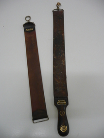
Accessory - RAZOR STROPS
Container (round flat box) of pink-coloured ('Peche') 'Cashmere Bouquet' Face Powder . Top of box ha Two razor strops. 'Gem' brand with attached metal clasp (opening clip); 'Malwa' brand with fixed clip; loose opening clip (from Malwa strop?). Shaped leather handle (detached) with the following in gold embossing - 'Specially Prepared'; '16' with surrounding wreath; map of Australia (with wreath). s product name and flower motif; back of box has manufacturer's details (Colgate Palmolive; Made in Australia etc.personal effects, shaving, razor strop -
 Bendigo Historical Society Inc.
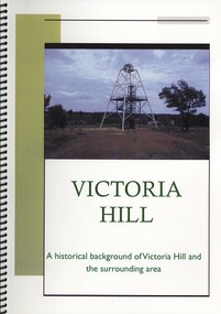
Book - VICTORIA HILL, A HISTORICAL BACKGROUND OF VICTORIA HILL AND THE SURROUNDING AREA, 2011
Victoria Hill a historical background of Victoria Hill and the surrounding area. Original article by Albert Richardson 1971 and revised and edited in 2012 by Philip Wilkin. Contains 26 pages with colour and black & white photographs and a map. Inside front cover is a 'Bendigo Miner' History Lives article by Jim Evans, dated 10 May 2012.Albert Richardson & Phillip Wilkinbendigo, mining, victoria hill -
 Bendigo Historical Society Inc.
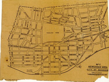
Newspaper - BENDIGO SEWARAGE AREA NEWSPAPER CUTTING, 1921
Newspaper cutting showing map of the No 1 Sewerage Area City of Bendigo. 1921bendigo, planning, sewerage, bendigo sewerage -
Bendigo Historical Society Inc.
Map - YARRAYNE : COUNTY OF BENDIGO, 6-1-32
... Inc. History House 11 Mackenzie Street Bendigo goldfields MAP ...Map. Yarrayne, County of Bendigo, Janiember East; Pompapiel, Salisbury, Bridgewater, Salisbury West, Powlett. Photo-Lithographed at the Department of Lands and Survey, Melbourne. Price 2/-. 6-1-32. (number 12 in map cupboard 1)H.J. Green, Government Printermap, bendigo, yarrayne -
Bendigo Historical Society Inc.
Map - YALLOOK : COUNTY OF BENDIGO, 1957
... Inc. History House 11 Mackenzie Street Bendigo goldfields MAP ...Map. Yallook, County of Bendigo,Talambe, Tandarra, Neilborough, Yarraberb, Salisbury, Pompapiel. Drawn and reproduced at the Department of Lands and Survey, Melbourne.1957. Price 2/-. By authority W.M. Houston, Government Printer. (number 11 in map cupboard 1)W.M Houston, Government Printermap, bendigo, yallook -
Bendigo Historical Society Inc.
Map - WARRAGAMBA : COUNTY OF BENDIGO, 29-4-30
... Inc. History House 11 Mackenzie Street Bendigo goldfields MAP ...Map. Warragamba, County of Bendigo, Pannoomilloo, Kamarooka, Minto, Diggorra. By authority H.J. Green, Government Printer. Piccaninny Creek. Drawn and reproduced at the Deparment of Lands and Survey, Melbourne. 29-3-30. Price2/-. (number 10 in map cupboard 1)H.J. Green, Government Printermap, bendigo, warragamba -
Bendigo Historical Society Inc.
Map - WANURP : COUNTY OF BENDIGO, 1-12-33
... Inc. History House 11 Mackenzie Street Bendigo goldfields MAP ...Map. Wanurp, County of Bendigo, Terrick Terrick East, Mitiamo, Milloo, Pannoobamawm. By authority H.J. Green, Government Printer.Photo-Lithographed at the Department of Lands and Survey, Melbourne. Price 2/-. 1-12-33. (number 9 in map cupboard 1)H.J. Green, Government Printermap, bendigo, wanurp -
Bendigo Historical Society Inc.
Map - TALAMBE : COUNTY OF BENDIGO, January 1956
... Inc. History House 11 Mackenzie Street Bendigo goldfields MAP ...Map. Talambe, County of Bendigo, Hayanmi, Pompapiel, Dingee, Tandarra, Yallook. By authority W.M. Houston, Government Printer, Melbourne. Drawn and reproduced at the Department of Lands and Survey, Melbourne. January 1956. Price 2/-. (number 8 in map cupboard 1)W.M. Houston, Government Printermap, bendigo, talambe -
Bendigo Historical Society Inc.
Map - SEDGWICK : COUNTY OF BENDIGO, 1963
... Inc. History House 11 Mackenzie Street Bendigo goldfields MAP ...Map. Sedgwick, County of Bendigo, Strathfieldsaye, Eppalock, Lyell, Mandurang, Sutton Grange. By Authority A.C. Brooks, Government Printer, Melbourne. Drawn and reproduced at the Deparment of Lands and Survey, Melbourne. 1963. Price 2/-. (number 7 in map cupboard 1)A.C. Brooks, Government Printer.map, bendigo, sedgwick -
Bendigo Historical Society Inc.
Map - SALISBURY : COUNTY OF BENDIGO, 1965
... Inc. History House 11 Mackenzie Street Bendigo goldfields MAP ...Map. Salisbury, County of Bendigo, Pompapiel, Yarrayne, Yarraberb, Yallook, Bullock Creek. By Authority: A.C. Brooks, Government Printer, Melbourne. Drawn and reproduced at the Department of Lands and Survey, Melbourne.1965. Price $1.00. (number 6 in map cupboard 1)A.C. Brooks, Government Printermap, bendigo, salisbury -
Bendigo Historical Society Inc.
Map - RAVENSWOOD : COUNTY OF BENDIGO, 1971
... Inc. History House 11 Mackenzie Street Bendigo goldfields MAP ...Map. Ravenswood, County of Bendigo, Township of Ravenswood, County of Talbot, Bradford; Walmer; Harcourt; Lockwood; Mandurang; Sutton Grange.By Authority C.H.Rixon, Government Printer, Melbourne.Drawn and Reproduced at the Dept. of Crown Lands and Survey, Victoria. 1971. Price $1.00 (number 5 in map cupboard 1)C.H.Rixon, Government Printermap, bendigo, ravenswood -
Bendigo Historical Society Inc.
Map - POMPAPIEL : COUNTY OF BENDIGO, 1-10-27
... Inc. History House 11 Mackenzie Street Bendigo goldfields MAP ...Map. Pompapiel, County of Bendigo, Calivil, Janiember East, Yarrayne, Salisbury, Yallook, Talambe, Judyong Creek, Bullock Creek, Pompapiel Creek, Edeyrn Estate. Photo-Lithographed at the Department of Lands and Survey, Melbourne by W.J. Butson, 1-10-27, Price 1/-. (number 4 in map cupboard 1)W.J. Butson, Government Printermap, bendigo, pompapiel -
Bendigo Historical Society Inc.
Map - PANNOOMILLOO : COUNTY OF BENDIGO, 1957
... Inc. History House 11 Mackenzie Street Bendigo goldfields MAP ...Map. Pannoomilloo, County of Bendigo, Milloo, Warragamba, Diggorra, Pannoobamawm. Drawn and reproduced at the Department of Lands and Survey, Melbourne,1957. Price 2/-. By Appointment W.M. Houston, Government Printer, Melbourne. (number 3 in map cupboard 1)W.M. Houston, Government Printermap, bendigo, pannoomilloo -
Bendigo Historical Society Inc.
Map - PANNOOBAMAWM : COUNTY OF BENDIGO, 1957
... Inc. History House 11 Mackenzie Street Bendigo goldfields MAP ...Map. Pannoobamawm, County of Bendigo. By Appointment W.M. Houston, Government Printer, Melbourne. Drawn and reproduced at the Department of Lands and Survey, Melbourne. Price 2/-.1957. Turrumberry, Terrick Terrick East, Wanurp,Pannoomilloo, Bamawm, Pannoobamawm. (number 2 in map cupboard 1)W.M. Houston, Government Printermap, bendigo, pannoobamawm -
Bendigo Historical Society Inc.
Map - NOLAN, COUNTY OF BENDOGO, 7-5-30
... Inc. History House 11 Mackenzie Street Bendigo goldfields MAP ...Map, Nolan, County of Bendigo, Egerton; Elmore; Goornong. Campaspe River, Elmore Estate, By Authority: H.J.Green, Government Printer,Melbourne.Price 2/-.Drawn and Reproduced at the Dept. of Lands and Survey,Melbourne,Victoria.7-5-30. (number 1 in map cupboard 1)H.J.Green,Government Printermap, bendigo, nolan -
Bendigo Historical Society Inc.
Map - NERRING : COUNTY OF BENDIGO, August 1952
... Inc. History House 11 Mackenzie Street Bendigo goldfields MAP ...Map. Nerring, County Of Bendigo. Yarraberb, Neilborough, Huntly, Sandhurst, Leichardt, Marong. Drawn and reproduced at the Department of Lands and Survey, Melbourne,Victoria. August 1952, Price 2/-. By Appointment J.J. Gourley, Government Printer, Melbourne. (number 0 in map cupboard 1)J.J. Gourley,Government Printermap, bendigo, nerring -
Port Melbourne Historical & Preservation Society
Map - Albert Park, South Melbourne and part of Port Melbourne, MMBW
Melbourne and Metropolitan Board of Works Plan 9E-NE depicting Albert Park, S. Melbourne and (part of) Port Melbourne.mmbw, melbourne and metropolitan board of works -
Port Melbourne Historical & Preservation Society
Map - Port Melbourne, Department of Lands and Survey, 20 Sep 1932
Dept. of Lands and Survey Map Sheet 5 Port Melbourne, Parish of South Melbourne.Annotated re MHT precincts on foreshore:Plan sketches re boat harbourtown planning, sandridge lagoon, melbourne harbor trust - port of melbourne authority, transport - railways -
Port Melbourne Historical & Preservation Society
Map - MMBW, c. 1894
Melbourne and Metropolitan Board of Works Plan No. 323,330, 335, 336 Segments shown: As Plan No. Large scale plan of lagoon fill area (40'=1")engineering - board of works, sandridge lagoon, transport - tramways, engineering - canals and drainage, built environment, gasworks, business and traders - hotels -
Port Melbourne Historical & Preservation Society
Map - MMBW, 1897
... , Nott and Dow Streets. Map MMBW ...Melbourne and Metropolitan Board of Works 1895, Plan No. 324, 328, 329 Segments shown: (as plan No's.) Large scale showing hotels, civic and industrial buildings, Graham Street to Bay, Nott and Dow Streets.engineering - board of works, business and traders - hotels, built environment, piers and wharves - town pier, transport - tramways -
Port Melbourne Historical & Preservation Society
Map - MMBW, 1894
Melbourne and Metropolitan Board of Works 1894 Plans No. 338, 339, 355, 356 Segments shown: As plan No's: Bridge to Graham, Evans to Nott. (Large scale - 40'=1")311/H, 17engineering - board of works, built environment, education - primary schools, graham street state school, port melbourne primary school, business and traders - hotels -
Port Melbourne Historical & Preservation Society
Map - MMBW, 1895
MMBW 1895 Plan No's. 344 to 349 Segment: Ingles to Bridge, Nott to Esplanade East (on south) Scale 40ft=1" (large)311/H 22melbourne and metropolitan board of works, port melbourne town hall, built environment, business and traders - hotels -
Port Melbourne Historical & Preservation Society
Map - MMBW, Oct 1894
Melbourne and Metropolitan Board of Works 1894 Plan No. 10 Segements shown: 363, 367 and 368 Large scale (40'=1") Swallow Street to Railway Place, Railway pier to mid railyards"Copywrited 14.1.95" written in red ink "311/H"engineering - board of works, business and traders - hotels, transport - railways, transport - tramways