Showing 11608 items matching "surveyor-general"
-
 Port Melbourne Historical & Preservation Society
Drawing - Sketch, Shelter shed, Town Pier, Sandridge, 20 May 1862
Sketch of proposed shelter shed for Town Pier, 1862.Ball, Frederick William (Municipal Surveyor 1860s)piers and wharves - town pier, frederick william bull -
Stawell Historical Society Inc
Map - Picture, Plan of Mining Leaseholders and of Land Applies for under Mining Lease November 1887. Plus photocopy, 1887
Lists Businesses in Stawell Trade Directory Mines Listed. New Darlington Mine, Moonlight Junction, Magdala Extended, Moonlight Consols, North Magdala Moonlight, Magdala No 1,Pioneer & Galatea, Pleasant Creek Cross Reef, Moonlight, Moonlight Extended, Oriental, Cross Reef Consolidated, Sloanes and Scotchmans, Scotchmans United, Scotchmans & Cross Reefs,, New Perthshire, Federal, Wimmera Wonga And Birmingham, Rutlands, Wonga ExtendedFramed Stawell Trade Directory 1887 and Plan of Mining Leaseholders and of Land Applies for under Mining Lease November 1887. Plus photocopy.W C Bates Mining Surveyor 4.11.87stawell -
 Kiewa Valley Historical Society
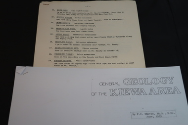
Information on Geology, Flora, Birds of the Kiewa Area, C1960
Information of the Kiewa area commissioned by the State Electricity Commission of Victoria for use by the general public.To inform the interested public, visiting the Kiewa area, about the Geology, Flora and birds as documented by various professionals and commissioned by the State Electricity Commission of Victoria.1. Foolscap x 4 sheets, numbers 11-80 list of birds and description 2. A4 size x 4 sheets "Birds of the Bushland" 3. A4 size x 4 sheets "The Three Floras of Bogong" 4. A4 Size x 4 sheets "General Geology of the Kiewa Area" 1. -2- centre top of first page. List of birds 11-27. …/3 bottom Rt. hand corner of top page 2. Photocopied sheets, printed on Rt. side of paper only. Heading is "BIRDS of the BUSHLAND" followed by diagrams and name of 13 birds. Photocopied using right half of paper only. 3. 'THE THREE FLORAS OF BOGONG' inside a rectangular box. Midway down page 'Published by the State Electricity Commission of Victoria" and towards bottom of page 'October, 1964'. Both inscriptions inside a rectangular box. Photocopied using right half of paper only. 4. photocopied sheets on right side of paper only, GENERAL GEOLOGY OF THE KIEWA AREA by F>C> Beavis, Ph.D., B.SC. June, 1963. 4.flora; geology; birds; kiewa area; secv; tourism; environment -
 Warrnambool and District Historical Society Inc.
Ledger, Letter book 1892-1904, 1892
This letter book has letters, sketch maps and plans and dates from 1892 to 1904. It came from the office of John William Crawley, Junior, an engineer, architect and surveyor in private practice in Warrnambool and also the engineer of the Shire of Warrnambool from 1895 to 1935. His father, brother and son were also engineers and worked in that capacity or as the Shire Secretary for the Shire of Warrnambool, with the Crawley family recording a total of 132 years of service to the Shire. This letter book was passed on to John Crawley’s son, Rolf Crawley, Engineer for the Shire of Warrnambool from 1935 to 1968. The letter book then came into the possession of Michael Hand who took over the private surveying business of Rolf Crawley in Warrnambool. The Warrnambool and District Historical Society has acquired the letter book, one of several Crawley ledgers, from the Michael Hand estate. This letter book is of considerable significance as it contains maps, plans, sketches and written information which is the work of John William Crawley Junior, the engineer for the Shire of Warrnambool for 40 years. It will be very useful to researchers. This is a hard cover letter book of 500 pages. The cover is black with leather binding on the edges of the cover and on the spine. The pages contain an alphabetical listing of the letters, handwritten letters and many sketch maps and plans. There are several loose pages of plans and diagrams at the back of the book. The inside of the covers has a blue mottled pattern. The edges of the cover are torn. There is a mauve stamp on the first page. ‘Letter Book 1892 to 1901’ ‘Rolf L. Crawley, Civil Engineer, Drainage and Water Supply Engineer, Licensed Surveyor, Registered Architect, Warrnambool’ john william crawley, junior, warrnambool, rolf crawley, warrnambool, shire of warrnambool -
 Orbost & District Historical Society
black / white photograph, 1897
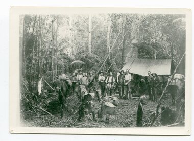
Link with item 1178. This is a surveyors' camp in the McCulloch Ranges, Murrangowar, April, 1897. Included in the photograph are: L. Thorn; Pearson; L. Coburn, Clem Bates; Sam Blacklock with a packhorse. They were surveying for a road or railway. Surveyors were among the first European settlers to arrive in Australia. A Surveyor-General was present on the First Fleet, as well as the first two ships which landed in South Australia. These men were issued with instructions to record observations in a journal that included the country’s general appearance, its soil, flora and fauna and the customs and language of local inhabitants. The conditions they worked in were harsh and they embarked on journeys with drays carrying cumbersome surveying and camping equipment, spending months camping out in the bush and mapping the land. It was not until well into the second half of the nineteenth century that the professional training of surveyors became mandatory in Australia.This is a pictorial record of a surveyors' camp in the late 19th century.A black / white photograph of a group of men standing in front of a tent / camp in a dense bush setting.surveyor's-camp-mccullochs-ranges-murrangowar land-settlement -
 Halls Gap & Grampians Historical Society
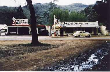
Photograph - Coloured, C 1960
The second general store in Halls Gap, built by Jack and Clarrie Thomson. Halls Gap newsagency now (2009) stands on this site. Probably taken at the same time as record 253 (as the yellow car appears to be in the same spot).The photo shows a garage and a general store. There is an Esso sign in front of the buildings and the store sign reads Thomson's general Store. There is a bitumen road, with a yellow early model Holden parked on it, in front of the store. The Mount Willliam range in the background. There appears to be snow or hail lying on the ground in the foreground.buildings, shops -
Whitehorse Historical Society Inc.
Document, List of Victorian Governments, 1966
List of Victorian GovernmentList of Victorian Government: Premiers, Governors, Governor Generals, Speakers and Presidents 1851-1966. Also populations and references to books on Victorian history.List of Victorian Governmentpolitics & government, victoria government, govenors, premiers -
 Surrey Hills Historical Society Collection
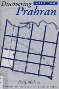
Book, Discovery Prahran - Area Two, 1999
This booklet provides a general picture of Prahran as it developed from the first Crown land sales of 1840 to its amalgamation with the City of Malvern in 1994This booklet provides a general picture of Prahran as it developed from the first Crown land sales of 1840 to its amalgamation with the City of Malvern in 1994prahran (vic) - history, toorak (vic) - history, armadale (vic) - history, (ms) betty malone -
 Greensborough Historical Society
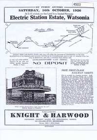
Advertising Leaflet, Electric Station Estate; Watsonia; Saturday 16th October 1926, 16/10/1926
This is one of two brochures advertising the auction of the last 50 allotments of the Electric Station Estate, Watsonia, near the new railway station. This brochure contains a locality plan and drawing of the general store. (Refer 4526 for the other brochure for this auction) Auctioneer: Knight & Harwood.One page B & W Photocopy (laminated) of auction brochure, with drawing of general store and locality planwatsonia railway station, watsonia, electric station estate -
 Kiewa Valley Historical Society
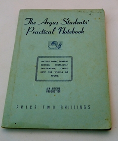
Book - Student's Text, The Argus Students' Practical Notebook, 28/09/1948
Printed by the Argus and Australasian Limited in 1948 as a general text book for students. The Argus Newspaper had been printing interesting, informative and instructive articles on various phases of the work in schools every Saturday in their newspaper and the students were expected to cut these articles out and paste them in a convenient form for study and revision. The decision to publish the articles, by the Argus, in one volume was welcomed by the Director of Education, Victoria, J.A. Seitz and stated that it "can be recommended confidently to teachers and pupils."Gives a general overview of a lot of different subjects that students were being taught in the 1940's.It includes such areas as the three layers of government, simple mechanics and electrical theory, nature and general science. It is typical of what was being taught during the construction days in the Kiewa Valley and the owner would have possibly attended either the Tawonga State School or the Mt. Beauty State School. A green paper back text book of general knowledge. Contains nature notes, general science, Australian exploration, civics, and how the wheels go round. This is an Argus Production and the price is stated as two shillings.On the front cover, written in ink, is a name Helen Gunn, A1. This is repeated on the first page with two crosses underneath the inscription.argus newslpaper, general knowledge, education, pupils, text book -
Federation University Historical Collection
Document, Order in Council (Victoria) Rules for Mining Surveyors in the Ballarat Mining District, 1867, 1867
White Foolscap printed Government document listing rules for mining surveyors in the Ballarat Mining Districmining surveryoring, surveying, surveyor, ballarat mining district -
Clunes Museum
Document
STAPLED REPORT BY CONSULTING ENGINEERS ,SURVEYORS STRUCTURAL REPORT - CLUNES MUSEUM 7 SEPTEMBER 1998local history, document, structual appraisal, structual appraisel -
 Tatura Irrigation & Wartime Camps Museum
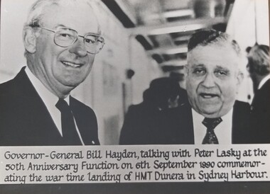
Photograph, Bill Hayden and Peter Lasky, 1940
Peter Lasky, Dunera boy, talking with Governor General Bill Hayden at the 50th anniversary, Dunera reunion.Black and white photograph of Governor General Bill Hayden, talking with Peter Lasky at the 50th anniversary on 6 September 1990. Commemorating and landing of the Dunera 1940.dunera boys, dunera reunion, 50th aniversary dunera reunion, peter lasky, bill hayden, australian governor general -
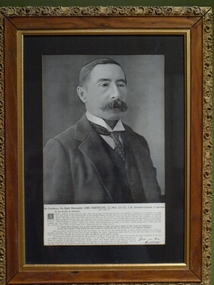 Clunes Museum
Photograph, Crown Photographers
Lord Northcote was Australia's 3rd Governor General.Framed black and white photograph of the Governor General of Australia Lord Northcote. Carved frame around edge, gilt edge on inside of frame. Typed message on rectangular paper by Lord Northcote.lord northcote, governor general, politics -
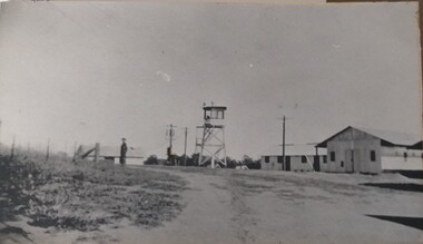 Tatura Irrigation & Wartime Camps Museum
Photograph, Camp Buildings and sentry tower, 1939
Dhurringile camp view. General view of buildings, sentry tower and a lone guard.Black and white photograph of general view of huts, lookout tower, fence and lone soldier with road sweeping front right, swinging left. Taken at Dhurringile Mansion camp.dhurringile pow camp -
 Uniting Church Archives - Synod of Victoria
Photograph, 1955 - 1962
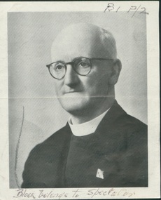
Alec Pederick was born in 1902 and left school at 15 to work on his parents' farm at Wyuna, Kyabrum,Victoria. After receiving a sense of call he trained for the Methodist ministry and was appointed to his first parish at Zeehan, Tasmania in 1927. He was called to serve with the Methodist Overseas Mission in New Britain and New Ireland in 1929. He married Dorothy Clarke just before he left. After four years in PNG he returned through ill-health to Victoria. He was appointed to the Beaufort Circuit in 1933 and then in 1936 to the Methodist Home Missions Department. He was called up as an Army chaplain in 1942 and sent on active service in Papua New Guinea. He was discharged in 1944 and returned to the Home Missions Department. He was appointed acting General Superintendent in 1944 and then General Superintendent in 1946, a position he held until 1962. He also served as Director of the Federal Methodist Inland Mission for a time. He died in 1972.Set of 8 photos (F68-3 has two additional copies) of Rev. Alec W. Pederick L. Th. All six photographs were taken at approximately the same age - late middle age - while still General Superintendent of the Victorian Home Missions department. Mostly bald, bespectacled man wearing glasses and clerical collar and stock and dark suit. All B&W. F68-1 is a cutting from The Spectator. F68-2 shows Pederick looking directly at the camera, unsmiling. F68-3 shows Pederick smiling looking to the right of the camera. F68-4 and F68-5 were taken as he was seated holding a large, open folder of papers, looking at the folder in -4 and to the right of the camera in -5. F 68-6 shows Pederick standing outside in a garden or "the bush" dressed in clerical garb with an overcoat. He is holding what looks like a camera and he is looking away from the camera.All the photos except F68-6 have an identification by name (Rev. A. W. Pederick" and all bar F68-6 have also identified him as General Superintendent and F68-3-5 identify him as General Superintendent Methodist Home Missions. F68-3 has "President of Conference 1955" typed on the back in red ink.pederick, a. w., zeehan, methodist overseas mission, methodist inland mission, beaufort, army chaplain, new britain, new ireland -
 Mont De Lancey
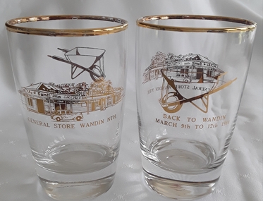
Domestic object - Drinking Glasses, 1984
Souvenir glassware to commemorate Back to Wandin Nth March 9th to 12th 1984A pair of memorial heavy based gold trimmed drinking glasses with gold lettering to commemorate Back to Wandin March 9th to 12th 1984 with a gold wheelbarrow at the top. There is also a General Store Wandin Nth gold inscription with a gold printed picture of the store above.Back to Wandin March 9th to 12th 1984 with a gold wheelbarrow. Also, General Store Wandin Nth with a picture of the store in gold.glassware, memorial glasses, tableware -
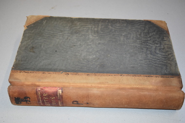 Warrnambool and District Historical Society Inc.
Letter book 11, Letters 1926 - 1929, 1926
This letter book contains handwritten letters and sketch maps and dates from 1926 to 1929. It came from the office of John William Crawley Junior, an engineer, surveyor and architect in private practice in Warrnambool and also the engineer for the Shire of Warrnambool from 1895 to 1935. His father, brother and son were also engineers and worked in that capacity or as the Shire Secretary for the Shire of Warrnambool, with the Crawley family recording a total of 132 years of service to the Shire. The Shire of Warrnambool existed from 1863 to 1994. The letter book was passed on to John Crawley’s son, Rolf, the engineer for the Shire of Warrnambool from 1935 to 1968. It then came into the possession of Michael Hand who took over the private surveying practice of Rolf Crawley. The Warrnambool and District Historical Society acquired the letter book, along with several other Crawley ledgers, from the estate of Michael Hand. This letter book is of considerable significance as it contains letters and maps drawn up by John William Crawley, Junior who had a private engineering and surveying practice in Warrnambool and was the engineer for the Shire of Warrnambool for 40 years. It will be very useful for researchers. This is a green hard cover letter book of 1000 pages. It has handwritten letters and sketch maps and an alphabetical index at the front. The cover has brown binding on the edges of the cover and the spine. There is gold lettering on the spine. The cover has an inside mottled red lining. There is a mauve stamp on the first page. ‘Letter Book 1926 to 1929’ ‘P’ ‘Rolf. L. Crawley, Civil Engineer, Drainage and Water Supply Engineer, Licensed Surveyor, Registered Architect, Warrnambool’ john william crawley junior, warrnambool, rolf crawley, warrnambool, shire of warrnambool -
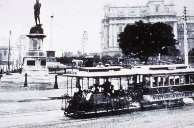 Melbourne Tram Museum
Slide - Black and white reproduction photograph - Macarthur St with General Gordon Statue, c1920
Photograph - of a city bound cable tram from Victoria St to Spencer St passing the General Charles Gordon statue that was erected in 1887, General Gordon died in Khartoum in 1885. Photo has the Windsor Hotel and Parliament house in the background - c1900. See reference for the statue and Gordon''s history.Yields information about the Gordon reserve and a Victoria Street cable tram.Kodachrome cardboard duplicate slide - Black and white reproduction photograph - Macarthur St with General Gordon Statue. Negative also held. See item 8358 for a similar image. "CB10" in penciltrams, tramways, cable trams, macarthur street, general gordon, statues, victoria street -
 Marysville & District Historical Society
Map (Item) - Tourist Map, Department of Lands & Survey, Tourist's Map of Narbethong and Marysville Districts Victoria, 1913
A tourist map for the Narbethong and Marysville Districts that was originally produced by the Department of Lands & Survey in 1925.A tourist map for the Narbethong and Marysville Districts that was originally produced by the Department of Lands & Survey in 1925.Reprint of the 1925 Tourist brochure by permission R.E. Holmes Surveyor General By Authority: ALBERT J. MULLETT, Government Printer, Melbourne. Photo Lithographed at the Department of Lands and Survey Melbourne by W.J. Butson/ 26.8.13narbethong, marysville, victoria, department of lands & survey, the acheron valley, warburton, map, tourist map -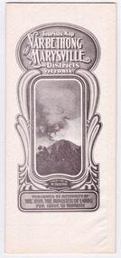
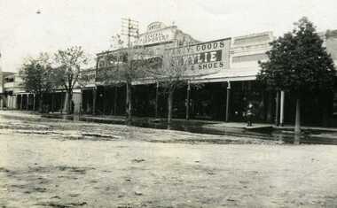 Charlton Golden Grains Museum Inc
Photograph, Flood 1911, c.1911
Flood 1911. High St Charlton showing Golden Fleece Hotel and W. Wylie General StoreSmall black & white snapshot showing Golden Fleece Hotel and W. Wylie General Store. Two children standing on the footpath. Water on the road in front of them. charlton, flood, willey, willey store -
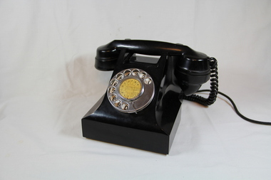 Emerald Museum & Nobelius Heritage Park
Telephone, Postmaster General (PMG) issue 1940-1970
Telephone used in all households as standed issue for the Postmaster General (PMG) from the 1940's.Black bakerlite telephone with dial face and hand set, with long connection cord.On base PMG 300 S.T.C. 51 S1/90 Old Telephone No JW1503 Face: ABFJLMUWXY {listen before calling} pull dial round to stop and let go. -
Port Melbourne Historical & Preservation Society
Plan - Lagoon outlet, Sandridge, 13 Nov 1861
Plan of outlet of lagoon showing proposed new channel, 1861.Signed by Fredk. Wm. Ball, Municipal Surveyor, Sandridge.sandridge lagoon -
Port Melbourne Historical & Preservation Society
Map - Lagoon between Ingles and Spring Streets, Sandridge, 26 Mar 1872
Prepared by Mr ORME for the Lagoon Committee and presented with a report on 26.3.1872.Map of Lagoon between Ingles Street and Spring Street. 26 March 1872. In brown wooden frameBorough Surveyor's Stamp in bottom right hand corner.sandridge lagoon, mr orme -
Port Melbourne Historical & Preservation Society
Plan - Tramway, Normanby Road, Ingles Street to Boundary Street, Port Melbourne, 14 Mar 1893
Plan of tramway in Normanby Road from Ingles Street to Boundary Street, together with written specification for works attached (Reg 66.2), 1893.A.V. Heath (Town Surveyor) J.J. Bartlett (Mayor)engineering - roads streets lanes and footpaths, transport - tramways, town planning, town clerks, mayors, arthur victor heath, james john bartlett -
Port Melbourne Historical & Preservation Society
Document - Specification, Tramway, Normanby Road, Ingles Street to Boundary Street, Port Melbourne, 14 Mar 1893
Written specification for works attached to plan of tramway in Normanby Road from Ingles Street to Boundary Street (Reg 66.1), 1893.A.V. Heath (Town Surveyor) J.J. Bartlett (Mayor)engineering - roads streets lanes and footpaths, transport - tramways, town planning, town clerks, mayors, arthur victor heath, james john bartlett -
Port Melbourne Historical & Preservation Society
Plan - Williamstown Road, Derham Street to Raglan Street, Port Melbourne, 14 Mar 1893
Plan of Williamstown road from Derham street to Raglan street. (67.1), together with written specification of works attached. (67.2), 1893.A.V. Heath (Town Surveyor). J.J. Bartlett (Mayor).engineering - roads streets lanes and footpaths, arthur victor heath, town clerks, james john bartlett, mayors -
Port Melbourne Historical & Preservation Society
Document - Specification, Williamstown Road, Derham Street to Raglan Street, Port Melbourne, 14 Mar 1893
Written specification of works attached to plan of Williamstown Road from Derham Street to Raglan Street. (67.1) 1893.A.V. Heath (Town Surveyor). J.J. Bartlett (Mayor).engineering - roads streets lanes and footpaths, arthur victor heath, town clerks, james john bartlett, mayors -
Port Melbourne Historical & Preservation Society
Document - Specifications, Main drain, west branch, Evans Street to Esplanade East, Port Melbourne, Arthur Victor Heath, Town Clerk et al, 14 Mar 1893
Specifications for the construction of main drain west branch 1893 (together with plan attached - refer 75.2)A.V. Heath (Town Surveyor):J.J. Bartlett (Mayor)engineering - canals and drainage, arthur victor heath, town clerks, james john bartlett, mayors