Showing 112730 items
matching tracks/roads
-
 Whitehorse Historical Society Inc.
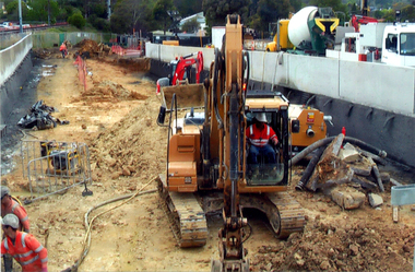
Photograph, Mitcham Railway Station construction 2013-14
The original Mitcham Station was opened on 25th December 1882. Until the 1970s a shunting yard and goods shed existed where the southern car park is now. Tracks remained embedded in the car park for many years. In 1979 boom gates were provided at both Mitcham Road and Rooks Road. From December 2009 to January 2010 Mitcham Railway Station was used as a bus interchange when the realignment of tracks and construction of a new station occurred at Nunawading. The new Mitcham Station opened on 25th January 2014.Coloured photographs of the construction of the underground railway station at Mitcham in 2013-14 and the opening in 2014.mitcham railway station construction 2013-14, mitcham railway station opening 2014, mitcham railway station, rialway stations -
 Melbourne Tram Museum
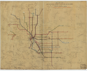
Drawing, Melbourne & Metropolitan Tramways Board (MMTB), "Route Map showing location of special work and pole numbers" "Electric Tramway Routes - showing routes in colours and numbers", late 1941
Map of the system shown at two inches = 1 mile. Drawing No. P5799. Shows crossovers, track layouts at junctions, signal cabins roads, railways and stations. Originally signed by Perway Engineer - 20/12/1940, though originally drawn in 1922. Has been marked up in coloured pencil to show the routes and route numbers. The plan shows the lines to Maribyrnong Munitions works along Cordite Ave and Wests Road and the track from Moonee Ponds to Union Road, which opened in July 1941, but not the extension to Essendon Airport built-in 1942. See Reg Item 1561 for a 1963 version and 1683 for a 1987 versionDemonstrates the use of a MMTB drawing to show tram routes and their route numbers at the time.Drawings - dyeline cloth backed print - titled - "Route Map showing location of special work and pole numbers" and subtitled - "Electric Tramway Routes - showing routes in colours and numbers". trams, tramways, mmtb, trackwork, tramways, junction, map, world war 2 -
![No.2 [Steam] Roller, Kew City Council](/media/collectors/550653872162f11fb04854aa/items/5c31f69121ea670d8459a8b6/item-media/5c31f77a21ea670d845a8063/item-fit-380x285.jpg) Kew Historical Society Inc
Kew Historical Society IncPhotograph, No.2 [Steam] Roller, Kew City Council, c.1950
The Number 2 Steamroller was used in public road building in Kew.It replaced the first Council steamroller which was used between 1915 and 1932.Rare photograph of a Kew City Council piece of road making machinerySmall black and white photograph of a steamroller used by the City of Kew in road construction from the 1930s to the 1950s.Reverse of photo: "KCC No 2 Roller 607S". Accompanying note: "20/3/84 Gift to the Society from Mr [?] who was K.C.C. [Kew City Council] driver of this "monster". Kew City Council No.2 Roller. Used in street construction 1950. Roller probably 1930 era."road construction - kew (vic), no.2 steamroller, steamrollers - kew (vic) -
 Greensborough Historical Society
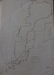
Maps, Shire of Heidelberg, 1920s
Map of main roads within Shire of Heidelberg, probably those for which the Shire was responsible for maintainingMap of main roads within Shire of Heidelberg, hand coloured, and Hurstbridge rail line. 40 chains: 1 inch971shire of heidelberg, heidelberg -
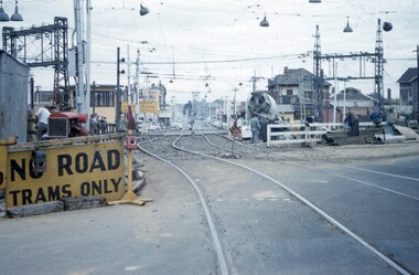 Melbourne Tram Museum
Slide - Set of 5, John Webster, 17/10/1959 12:00:00 AM
Set of five Colour slides, Kodak, brown cardboard of the removal of the Elsternwick Level crossing on 17-10-1959 .1 - looking east along Glenhuntly Road, showing the level crossing, concrete truck and road protection signs and the temporary track. .2 - W2 287 traversing the temporary track over the level crossing. Tram has the destination of route 4B, Sth Caulfield via Glenhuntly Road. Also has adverts for APEX and Fitwear socks. .3 - ditto on the crossing. .4 - ditto past the crossing. .5 - W2 551 (Carnegie Route 4) and L 103 (City route 4B) on the level crossing. 551 has adverts for Castle Vintage Sherry and Apex. 103 has adverts for Remy Martin Brandy, Alongside is a Victorian Railways sign advertising trains to the city.Hand writing on rear in ink; .1 - 17-10-59 - KFH1 .2 - KFH 1a .3 - KFH 1b .4 - KFH 1c .5 - KFH 1etrams, tramways, elsternwick, level crossings, railway squares, w2 class, l class, carnegie, south caulfield, glenhuntly rd, tram 287, tram 551, tram 103 -
 Phillip Island and District Historical Society Inc.
Photograph, 1978/79
Chicory Kiln alongside the house of Mr T Woods in Settlement Road, East Cowes, was built in approx. 1870. It had 18" thick mud brick walls at the core.Photograph of Chicory Kiln on Settlement Road, East Cowes, on land owned by Mr. T. Woods.local history, photographs, buildings - historical, housing, rural industry, coloured photograph, john cook, phillip island, t woods -
 Bendigo Historical Society Inc.
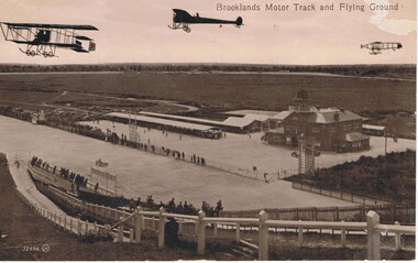
Postcard - BASIL WATSON COLLECTION: BROOKLANDS MOTOR TRACK AND FLYING GROUND
The postcard shows three planes flying above the Brooklands motor track with 'Brooklands Motor Track and Flying Ground'. To the right is a large two story brick building and on the left of the building is a long open covered vehicle stall. To the back are work sheds, further to the left are spectators cars and in the distance is open space with trees. Spectators line the race track both sides watching a racing car. In the foreground is a hill with fencing down to the track and spectators along the fence.Valentine Seriesaviation, civilian, brooklands motor track -
 Greensborough Historical Society
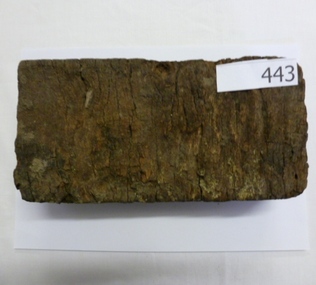
Brick, Wooden road block, 1880s
Accompanied by article by Kevin Patterson (Nillumbik Historical Society) which explains the use of these blocks as a road surface in the City of Melbourne from the 1880s. The final wood blocks were dismantled in the 1950s and blocks sent to suburban wood yards to be sold as fuel for open fires and combustion heaters.As most of these blocks were sold for fuel, it is unusual to find one surviving. Block of timber cut to size and dipped in tar for use a a road block. wood blocks, paving, melbourne, road surfaces, tar -
 Lakes Entrance Historical Society
Photograph - Princes Highway around Jemmys Point, Lakes Entrance, H D Bulmer, 1930 c
Princes Highway around Jemmys Point, car parked on road at junction of original steep road to top of Jemmys Point. Man on bicycle riding up hill. Bullock Island and New Works in distance over North Arm and Cunninghame Arm waterways Lakes Entrance VictoriaBlack and white photograph of lower section of Princes Highway around Jemmys Point, car parked on road at junction of original steep road to top of Jemmys Point. Man on bicycle riding up hill. Bullock Island and New Works in distance over North Arm and Cunninghame Arm waterways Lakes Entrance Victoriaroads and streets, township, waterways, fences, vehicles -
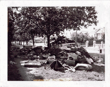 Kew Historical Society Inc
Photograph - Hard rubbish in the City of Kew
One of eight photographs donated by the City Engineer of the former City of Kew, mostly of hard rubbish clearance during the period 1969-1985.One of a dated series of photographs of core local government services as practised by the City of Kew in the period 1969-1985. Original black and white photographic positive of unburnable hard waste awaiting collection in Parkhill Road in the City of Kew.Reverse: "17th Nov 1969 8.45am. / Parkhill Road West of Adeney Avenue" In envelope marked: "Kew City Council / 12 photos / 1969 1979 18980 1985 / Unburnable rubbish units 18/1/80"garbage, hard rubbish, garbage removal, city of kew, local government -- city of kew, household waste, hard waste -
 Whitehorse Historical Society Inc.
Document, John McClare, n.d
Potted history of John and Mary McClare, arrived in Melbourne 1855 from Galway, Ireland.Potted history of John and Mary McClare, arrived in Melbourne 1855 from Galway, Ireland. Bought 55 acres on Canterbury Road. He paid 4 ponds per acre. he carried goods to the goldfields with his bullock team. Later he had a tannery and leather business on Canterbury Road. Their 1st child, Agnes was first white child born in the district. in 1862 John brought out his wife's brother and 2 sisters. Katherine and John Madden. John Madden took a selection on the south side of Canterbury Road.Potted history of John and Mary McClare, arrived in Melbourne 1855 from Galway, Ireland. mcclare, john, bowen, michael, mcclare, mary, mcclare, agnes, mcclare james, mcclare, rose, madden, katherine, madden, john, delaney's road, canterbury road, vermont, vermont -
 Ballarat Tramway Museum
Photograph - Digital image, Peter Bruce, "No. 26 and track cleaner", 1970s
Yields information about track maintenance and the Hospital Junction area.Digital image, black and white, of a track cleaner in white clothing sweeping out the track at Hospital corner with No. 26 approaching along Sturt St. Has the hospital in the background. Photo taken by Peter Bruce 1970's and 1971, prior to the closure of the Ballarat tramway system. Peter's Title of image: "No. 26 and track cleaner"trams, tramways, hospital corner, track, trackwork, tram 26 -
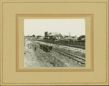 Kew Historical Society Inc
Photograph - Regrading the Camberwell Railway Line near Burke Road, E.J. Dower, 1915
One of a series of photographs, taken by Edgar James Dower in the second decade of the twentieth century. Born and raised in Olinda, his family later moved to Surrey Hills. He worked as an adult as a clerk in the city office of the Metropolitan Gas Company, and in his role as a 'collector', he was able to photograph scenes including the construction of tramlines, railways and associated buildings in Kew, Hawthorn, Camberwell and Surrey Hills. Later he established a real estate agency with his brother - the E.J. Dower Real Estate Agency, Dandenong Office.The image is an historically significant record of the development of transport infrastructure which was used to connect Victorians in the first two decades of the twentieth century. This development resulted from increases in population and the consequent extension of Melbourne's suburbs. The photographs, both individually and collectively, richly detail the labour of workers and the tools and machinery used to create and extend Melbourne's public transport network in the years preceding and during World War 1.Digital copy of an original mounted photograph depicting workers regrading the Camberwell Railway line following the demolition of the original Camberwell Railway Station. The level crossing gates at Burke Road can be seen in the distance. Named buildings include The Assembly Hall at right.Verso: "1915 / Regrading Camberwell Railway Line / Note Railway Gates on Burke Road / Taken by E.J. Dower"theme -- connecting victorians by transport and communications, theme - camberwell railway station, theme - travelling by train -
Melbourne Tram Museum
Document, Yarra Trams, "Notice to drivers" - bang road
Document issued by Kew Depot, titled "Notice to drivers" regarding driving on the wrong track (Bang Road) or from the rear end (reversing) not being permitted. Bang Road operation had to be supervised. Dated 1/6/2009, signed by Mario Taccone Depot Manager Kew.Demonstrates an instruction to crew re tram operations.Document - 1 A4 printed sheet yarra trams, trawmays, bang road, instructions, notices, kew depot -
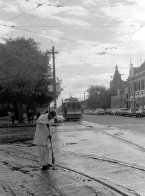
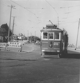 Melbourne Tram Museum
Photograph - VR 29 Baths Terminus, Jim Seletto, circa January 1958
The photograph shows VR tram No.29 with the destination "St Kilda Rly" near the Middle Brighton crossover. Road work signs indicate road closure and detours. In the background track excavation may be underway. The beach front and residential housing are also visible. Photo by J Seletto.Yields information about the last VR tramway and its progressive closure.Black and White photograph with photographer's notes on rearIn red biro on rear: 'VR Dreadailnought [sic] 29 baths Terminus Jan 58? D Print, JSE8'trams, middle brighton, vr trams, tram 29, closure, tramways, esplanade -
Clunes Museum
Functional object - LANTERN
LANTERN USED AS ROAD SIDE WARNINGS BY C.R.B. DURING ROAD WORKS AND EXCAVATIONS. LANTERNS WERE LIT BY WORKMEN TO GIVE WARNINGS TO NIGHT TRAVELLERS. ALSO USED ON DULL FOGGY DAYS. BURNERS REMOVABLE . C.R.B. STAMPED ON CAGE.RED PAINTED LANTERN, FORMERLY OWNED BY C.R.B. (COUNTRY ROADS BOARD) METAL CAGE WITH FUEL BOWL AND RED GLASS ENCASED. HINGED LID.C.R.B.lighting, kerosene, oil, lighting, country roads board -
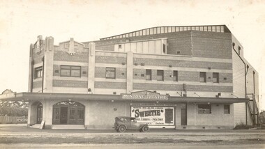 City of Kingston
Photograph - Digital image, Black and white, c.1928
Image of the newly opened Mentone Picture Theatre located on Point Nepean Road in Mentone. Local picture theatres abounded in the in the suburbs of Kingston from the 1920s through to the late 1950s. The New Mentone Picture Theatre was dreamt up and developed by Albert Lydford who along with other promoters, formed a company that provided the finance for the erection of a large cinema right at the junction of Balcombe Road and Point Nepean Road. The New Mentone Picture Theatre operated in competition with a council owned facility on Brindisi Street and within three years of opening, the council theatre was closed. The New Mentone Theatre flourished until the late 1950s. It offered three changes of program each week. Two movies screened on Mondays and Tuesdays. On Wednesday a new bill went on for just one night, and then the main feature of the week, a movie the likes of Casablanca, was shown from Thursday through to Saturday. During its heyday there were full houses almost weekly. Saturday night shows were often booked out in advance and some families had permanent bookings at weekends. Locals treated the place as a centre of social activity, a venue for an enjoyable night out that did not involve great expense or long travel times. The advent of television in the 1950's, saw the theatre close forever in 1960.Sepia toned image of the New Mentone Picture Theatre, located on Point Nepean Road, Mentone.theatre, movies, mentone, entertainment -
Glenelg Shire Council Cultural Collection
Photograph, Photograph - Lighthouse Estate, 1952
Port of Portland Authority ArchivesFront: Lighthouse Estate 5-11-52. View from Bentinck St showing new road and trees. Typed, centre bottom. Back: Purple PHT Stamp 1/2 39 5-11-52 in black ink.port of portland -
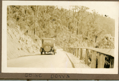 Mt Dandenong & District Historical Society Inc.
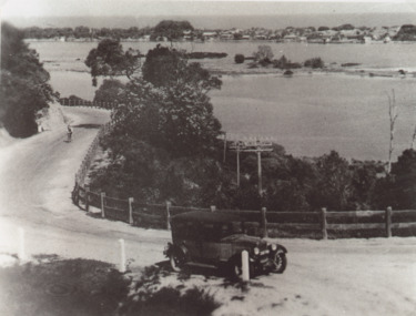
Photograph
The photograph is a pair to a similar photograph taken from the front view. The car is travelling down the CRB or Main Road at Kalorama c1930. Now named the Mt Dandenong Tourist Road. The photograph is glued in the Ivy Child Album. Ivy May Child (1910 – 1989) was the daughter of Arthur Edward (Ted) Child (1878 – 1964) and Ethel May Madden (1888 – 1970). Ted Child was the son of Matthew Francis Child (1839 – 1933) and Martha Jeeves (1857 – 1926). He was the grandson of one of the early pioneers Francis Child. Ivy grew up on the family property on Childs Road and took many photographs. Most of these are glued into her photo album. The album covered the years from c1927 – 1932. Ivy married Henry William Burgess (1906 – 1968) in 1944. The photographs remain in their original state in the album with individual copies made. Sepia coloured photograph showing an old car travelling down a road bordered by a rail fence.Written below the photograph in album: Going Downcar, automobile, ivy child, crb road, main road, mt dandenong tourist road -
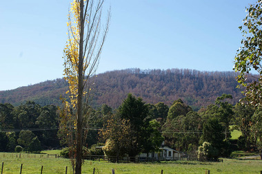 Marysville & District Historical Society
Photograph (Item) - Colour photograph, 2009
A digital copy of a colour photograph of a house on the Marysville-Buxton Road near Marysville in Victoria.A digital copy of a colour photograph of a house on the Marysville-Buxton Road near Marysville in Victoria.marysville-buxton road, marysville, buxton, victoria, photograph -
![Workers, horses and drays in Burwood Road [Hawthorn]](/media/collectors/550653872162f11fb04854aa/items/661f4c86ac7f9cfd1fd6c658/item-media/661f4d6bac7f9cfd1fd722a1/item-fit-380x285.jpg) Kew Historical Society Inc
Kew Historical Society IncPhotograph - Workers, horses and drays in Burwood Road [Hawthorn], E.J. Dower, 1913
One of a series of photographs, taken by Edgar James Dower in the second decade of the twentieth century. Born and raised in Olinda, his family later moved to Surrey Hills. He worked as an adult as a clerk in the city office of the Metropolitan Gas Company, and in his role as a 'collector', he was able to photograph scenes including the construction of tramlines and associated buildings in Kew, Hawthorn, Camberwell and Surrey Hills. Later he established a real estate agency with his brother - the E.J. Dower Real Estate Agency, Dandenong Office.The image is an historically significant record of the development of transport infrastructure which was used to connect Victorians in the first two decades of the twentieth century. This development resulted from increases in population and the consequent extension of Melbourne's suburbs. The photographs, both individually and collectively, richly detail the labour of workers and the tools and machinery used to create and extend Melbourne's tram network in the years preceding and during World War 1.Digital copy of an original mounted photograph depicting construction workers, horses and drays Hawthorn. The intense activity involved collecting materials for transport to the construction site in Cotham Road, Kew. Annotated recto: "Unloading trucks of metal for Kew Electric Tram Line in Cotham Road / At Hawthorn Railway Siding" Annotated verso: "Taken by E.J.D. / 1913"theme --- travelling by tram, theme -- connecting victorians by transport and communications, cotham road -- kew (vic.), trams -- kew (vic.), hawthorn railway station -
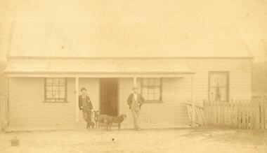 Ringwood and District Historical Society
Photograph, C. Gribble, Oliver Pratt's residence and Butchers Shop, Main Road (Opposite Mt.Dandenong Road), Ringwood. Two photos c.1910 and c.1914 (Multiple Copies)
Multiple copies of two photos of Oliver Pratt's residence and butchers shop, Main Road (Opposite Mt.Dandenong Road). Earlier photo shows Mr. Oliver Pratt (Left) and Mr. James Kenneth McCaskill (Right) outside residence (c.1910). Later photo (c.1914) taken after Pratt's first butcher shop was added before subsequent shop established on the corner of Warrandyte Road. (Orignial photo IDs were MHE999, MHE7, F27)Written on back of sepia photograph, "Mr. J. K. McGaskill. Main Road on Pratt's Land?" Typed below another photograph, "Mr. O. J. Pratt's Butcher shop, Main St. east of Warrandyte Rd. - 1912. -
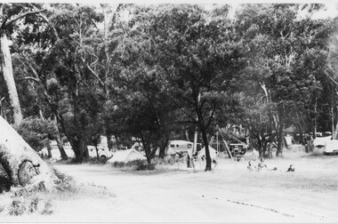 Halls Gap & Grampians Historical Society
Photograph - B/W
Campsites along the road leading to the Halls Gap shops.The photo shoes tents and cars amongst the bush beside a dirt road. Three people can be seen sitting/reclining on a rug in the right foreground.recreation, camping -
 Whitehorse Historical Society Inc.
Photograph - Black and white photograph, 'Bill's' Horse Trough Blackburn, 1977
North West corner of Canterbury and Blackburn Roads Blackburn.Black & white photo of 'Bills' Horse Trough, north-west corner of Canterbury and Blackburn Roads See page 97 of Da Costa book.blackburn road blackburn, canterbury road blackburn, horse troughs -
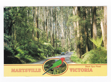 Marysville & District Historical Society
Postcard (item) - Colour postcard, Neil Cutts, Marysville Victoria-Black Spur Road, Pre 2009
A postcard in a series produced by the Rose Stereograph Company in Victoria, Australia as a souvenir of Marysville.A colour photograph of the Black Spur Road near Marysville in Victoria. The Black Spur is known to be one of Victoria's most scenic drives. The road winds through a majestic forest of trees and tree ferns from Healesville to Narbethong and is part of the Maroondah Highway. Rose Series postcard No. 3528. POST CARD The "Rose" Series/ De Luxe Proudly Printed in/ Australia Since 1880 AFFIX/ STAMP/ HERE/ Rose Series/ Post Card No./ 3528 ADDRESS/ POSTCODE Mountain Ash and Treeferns/ Black Spur Road/ MARYSVILLE, VICTORIA, AUSTRALIA/ Photo Neil Cutts Copyright Rose Stereograph Co., Glen Waverley, Victoria (03) 9560 7772marysville, victoria, black spur road, postcard, souvenir, rose series postcard, 3528, healesville, narbethong, maroondah highway -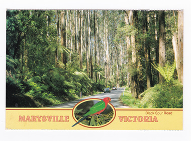
Whitehorse Historical Society Inc.
Document, Fr John McCristal, 1/05/1994 12:00:00 AM
Order of service for Eucharistic celebration, Fr John McCristal, 1917 - 1994.Order of service for Eucharistic celebration, Fr John McCristal, 1917 - 1994, at St Paschal's Franciscan Monastery, Albion Road, Box Hill.Order of service for Eucharistic celebration, Fr John McCristal, 1917 - 1994. mccristal, john (fr), st paschals franciscan monastery, box hill -
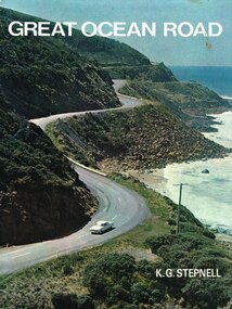 Otway Districts Historical Society
Book, Rigby Limited, Great Ocean Road. K.G. Stepnell, 1972
The Great Ocean Road may be the only road in the world which was built as a war memorial. In 1916, much of Australia was poorly served by roads, and it was suggested that returning servicemen could be given worthwhile employment by building roads in isolated areas. The plan was taken up for the Great Ocean Road, and work was dedicated to the memory of men who had fallen in World War 1. The road itself is a great feat of engineering. It wind around some of Australia's most rugged coastline. Now it is one of the world's most scenic routes, crossing gorges, along precipitous cliffs, through dense forests, and over steeply rolling coastline country.Great Ocean Road. K.G. Stepnell. 1st ed. Rigby Limited; Adelaide (S.A.); 1972. 36 p.; illus., maps. Hard cover. ISBN 0 85179 371 1great ocean road; roads; fishing; timber; twelve apostles; -
 Ballarat Tramway Museum
Slide - 35mm slide/s - set of 11, Eldon Hogan, 15/07/1972 12:00:00 AM
Set of 11 No. 35mm Agfa colour blue and white plastic mount slide - of the move of Ballarat trams 27, 28 and 14 from the old SEC depot onto the temporary access track to the BTPS depot on Saturday 15 July 1972 and Sunday 16 July 1972 (slides .10 and .11) .1 - John Withers and his land rover, towing No. 14 from the old depot - depot junction. .2 - No. 27 moves from Wendouree Parade onto the depot access track. .3 - ditto .4 - and onto the access track being pushed by hand. .5 - No. 28 being lifted onto the steel channels in order to slew it across Wendouree Parade .6 - being slewed across the road .7 - being readied to lift up onto the access track .8 - all three trams on the access track that evening. .9 - ditto Taken on 16 July 1972 .10 - No. 27 being winched up to the level crossing - Campbell Duncan ? on the winch. Note the mud! .11 - No. 14 being winched up the temporary access track - Rolf Jinks on the Winch. See Fares Please!, September 1972. tramways, trams, depot, btps, moving trams, wendouree parade, tram 27, tram 14, tram 28 -
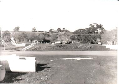 Hume City Civic Collection
Photograph, Early 1970s
The two arch bluestone bridge which spanned the Jacksons Creek was replaced in the early 1970s with a wider double lane bridge. Dangerous curves were also taken out of the road. The area in the foreground on the RHS has now been incorporated into a public picnic area.A black and white photograph of road works taking place on the Sunbury Road over Jacksons Creek. Large concrete drain pipes are in the foreground and on the RHS of the photograph with roadwork signs on the LHS. Three trucks are at the foot of the hill.macedon street, macedon street road bridge, jacksons creek, road construction, george evans collection