Showing 11127 items
matching planning
-
 Port Melbourne Historical & Preservation Society
Plan, Bay Street, C. 1990
A proposed plan for the development of Bay Street, Port Melbourne. The Street plan shows suggestions for tree planting, verandah changes, proposed open space & building use.bay street, built environment - commercial -
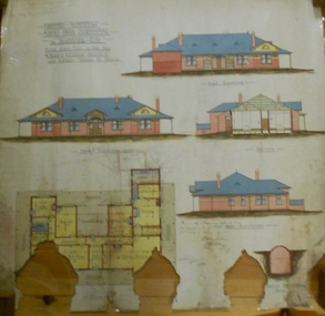 Bendigo Historical Society Inc.
Plan - MARKS COLLECTION: ALBERT PARK SERPENTINE HOUSE PLAN FOR H. LANSELL
Laminated plan showing house plan, side and front elevations, for house plan for H. Lansell, Serpentine. Hand coloured drawings and floor plan. Edwardian style shows large house with maid's quarters, cellar, dining room, bedrooms, dressing room. On top of plan written in black pen Proposed Homestead, Albert Park, Serpentine, for H. Lansell Esq, scale eight feet to one inch, W. Beebe & G.D. Garvin, architects, late W. Beebe, Mitchell Street, Bendigo..bendigo, house, albert park, serpentine -
Whitehorse Historical Society Inc.
Document, Eastern Freeway Extension, 2000 - 2002
Eastern Freeway ExtensionEastern Freeway Extension- Cost estimates for community consultation option Public consultation process : report on analysis submissions Deep Creek Road - Landscape concept Media Release from Premier of Victoria VicRoads - Works update newsletters Whitehorse City Council minutes VicRoads Correspondence Schwerkolt Cottage Precinct - Concept Plan VicRoads maps.Eastern Freeway Extensioneastern freeway extension, vicroads, victoria. department of infrastructure, city of whitehorse, schwerkolt cottage, landscape planning, maps -
 Kew Historical Society Inc
Plan - Subdivision Plan, Jas R Mathers Son & McMillan, Eastlawn Estate : East Kew Auction Sale, 1914
The Kew Historical Society's map collection includes a substantial number of real estate subdivision plans, mainly of Kew but also of surrounding suburbs in Melbourne. Most of the subdivision plans date from the 1920s and 1930s when the districts old homes and local farmland were being split up to accommodate residential growth in the postwar period. These early plans were assembled by a local firm, Jas R Mather & McMillan, which had an office in Cotham Road. Many of the plans, and sometimes photos, were annotated by the agents.Subdivision plans are historically important documents used as evidence for the growth of suburbs in Australia. They frequently provide information about when the land was sold as well as evidence relating to surveyors and real estate and financial agents. The numerous subdivision plans in the Kew Historical Society's collection represent working documents, ranging from the initial sketches made in planning a subdivision to printed plans on which auctioneers or agents listed the prices for which individual lots were sold. In a number of cases, the reverse of a subdivision plan in the collection includes a photograph of a house that was also for sale by the agent. These photographs provide significant heritage information relating house design and decoration, fencing and household gardens.The photograph may also be aesthetically significant depending on the importance of the photographic atelier.The ‘Eastlawn Estate’ was surveyed and ready for auction in March 1914, three months before the outbreak of World War I. Sixty-six allotments, created on the ‘order of Mr & Miss Preston’ surrounded the mansion of Woodlands in Harp Road. Woodlands formed part of the Estate, being advertised as lot 1. The allotments faced High, Station and Wright Streets, Harp and Normanby Roads, and Woodlands Avenue. Pru Sanderson in the Kew Conservation Study (Vol.2, 1988) wrote that the Eastlawn Estate ‘covered the western half of the failed Harp of Erin Estate’. Contemporary advertisements promoted the Eastlawn Estate as: ‘There will be no more convenient district nor pleasant Suburb than East Kew for the busy business man. When the Electric Tram is laid, he will be able to journey quickly and pleasantly direct from Collins Street to his home in the Eastlawn Estate in about 20 minutes’. The actual plans of subdivision were included in advertisements in The Argus and in the local newspapers."C" top left. Various annotations.subdivision plans - kew, station street, normanby road, high street, woodlands avenue, harp road, woodlands - kew -
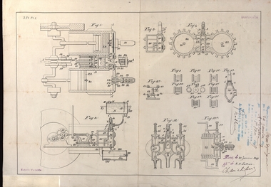 Federation University Historical Collection
Plan, French Patent Plan, 1899
Henry Sutton is a talented world-wide accepted inventor with inventions relating to the telephone, photography, wireless, cars, motorcycles, and bicycles as well as many more inventions. Henry was also one of four brothers that ran the Sutton's Music Store after the death of their Father Richard Sutton. Henry Sutton taught Applied Electricity at the Ballarat School of Mines in 1883 to 1886.Copy of plan used in the French patent of Henry Sutton french patent, henry sutton, plan, 1899 -
Glenelg Shire Council Cultural Collection
Plan - Plan - No. 6 Jetty Port Kembla Harbour, n.d
Port of Portland Authority Archivesport of portland archives, port kembla harbour -
Glenelg Shire Council Cultural Collection
Plan - Plan - Parking Plans Edgar Street Heywood, n.d
'Bower Bird' Museum, HeywoodParking plan for Edgar Street Heywood. Angle parking.Front: Back - 'Parking Heywood' - Red Pen -
Glenelg Shire Council Cultural Collection
Administrative record - Administrative record - Parking Plans, Edgar Street Heywood, n.d
'Bower Bird' Museum, HeywoodParking plan for Edgar Street Heywood- Parallel Parking -
Ringwood and District Historical Society
Envelope, Estate Agents - various plans and notes of Ringwood Subdivision
Estate Agents - various plans of Subdivision; Notes on Subdivisions -
 Ringwood and District Historical Society
Book, Maroondah City Council Corporate Plan 1997-2000, 2000
Maroondah City Council Corporate Plan 1997-2000 -
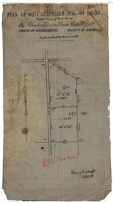 Federation University Historical Collection
Plan, Lease by Charles Edwin House, 1899, 1899
Plan on waxed linen for a lease by Charles Edwin House.house, charles house, gold lease, ballarat, alluvial claim -
 Federation University Historical Collection
Plan (copy), Ballarat Girls' Junior Technical School plan, 1958, 06/1958
Site plan showing the Ballarat Junior Technical Schoolballarat girls' junior technical school, ballarat girls' technical school, hickman street, white flat -
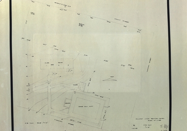
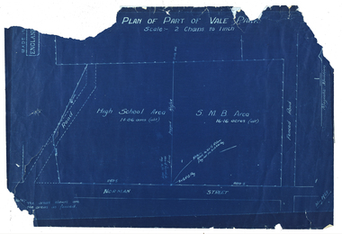 Federation University Historical Collection
Plan, Plan of Part of Vale Park, 1928, 15/1928
Probably the Ballarat School of Mines Farm or pine plantation.Ballarat Techncial School Norman StreetBlue line plan of part of Vale Park, Ballarat. vale park, ballarat school of mines, ballarat school of mines farm, ballarat high school, norman street -
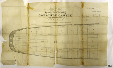 Flagstaff Hill Maritime Museum and Village
Plan
Plan of cabins of the river built ship 'Carlisle Castle'flagstaff hill, warrnambool, shipwrecked-coast, flagstaff-hill, flagstaff-hill-maritime-museum, maritime-museum, shipwreck-coast, flagstaff-hill-maritime-village, 'carlisle castle, plan -
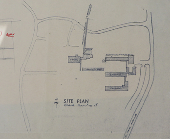
Federation University Historical Collection
Report, Ballarat School of Mines Report on Training for Caravan Park Managers, 1979, 02/1979
Ballarat School of Mines report . Planning Document 5.79ballarat school of mines, planning document, tafe, caravan park managers, j.l. turner, tourism -
 Federation University Historical Collection
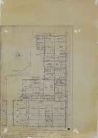
Plan, Ballarat Institute of Advanced Education Electrical Engineering Buillding Plans, 1972-1973, 1972-1973
Ballarat Institute of Advanced Education is a predecessor instituion of Federation University Australia. Five plans for the Mount Helen Campus E Building. ballarat institute of advanced education, electical engineering, e building, ewan jones, mt helen campus, architectural drawing -
Federation University Historical Collection
Plan, Ballarat School of Mines New Workshops Hotwater Supply, 1941, 1941
Service plan for new workshops at the Ballarat School of Mines.ballarat school of mines, new workshops, buildings, hotwater service, plans -
 Federation University Historical Collection
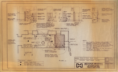
Plan, Ballarat School of Mines Additional Toilet/Shower Facility, 1985, 11/1985
Plan for additional toilet and shower for the Ballarat School of Mines. ballarat school of mines, toilet facility, shower facility, g.d. & n.e. hewitt -
 Federation University Historical Collection
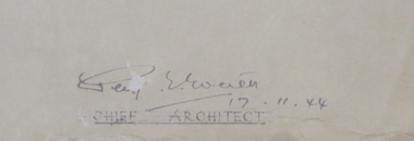
Plan, Ballarat School of Mines New Workshops, 1944, 17/11/1944
Three plans for new workshops at the Ballarat School of Mines.ballarat school of mines, new workshops, percy everett, architectural plan -
 Federation University Historical Collection
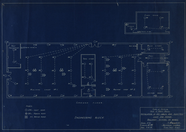
Plan, Ballarat School of Mines Engineering Block, 1939, 03/10/1939
Two plans for the Ballarat School of Mines Engineering Block. ballarat school of mines, engineering block, engineering, building -
 Federation University Historical Collection
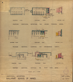
Plan, Ballarat School of Mines Additional Outoffices for Junior Technical School, 1952, 02/10/1952
Colour plan for outoffices, dressmaking and trade work shops.ballarat school of mines, buildings, percy everett, architectural plans -
Federation University Historical Collection
Plan, Barkley St Campus Diagram, 1985
Ink on paper plan: Barkley St Campus Diagram plan, smb, barkley st campus -
 Federation University Historical Collection
Plan, Ballarat School of Mines New Workshops, Albert Street, 1944
The Ballarat School of Mines is the first School of Mines in Australia, and was established in 1870.Black ink on paper plan: SMB New Workshops plans, smb workshops, percy everett, smb, ballarat school of mines -
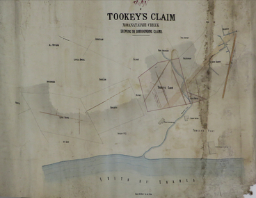 Federation University Historical Collection
Plan, Tookey's Claim Moanataiari Creek, 1869?
Ink on paper plan with blue, red and orange shading tookey's claim, moanataiari creek -
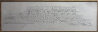 Federation University Historical Collection
Plan, Crushing Works, Port Phillip Company
Detailed mechanical engineering drawing of the Port Phillip Company Crushing Works at Clunes, VictoriaFramed plan of the Port Phillip Company's crushing works. Plaque: "Donated to the Metallurgy Department of Ballarat University College by noted Ballarat Author and Historian, A W Strange. 13/6/91" port phillip mine, plan, rivett henry bland, clunes, crushing works, mechanical engineering -
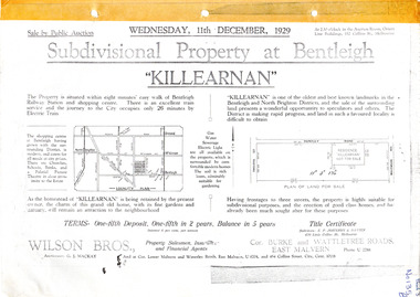 City of Moorabbin Historical Society (Operating the Box Cottage Museum)
Flyer - Killearnan Estate, McKinnon, 1929
The train line from the city to Frankston was electrified in 1922 which intensified the sale in the municipality of Moorabbin, particularly land which was in the vicinity of the railway stations.Example of the progress of the Municipality of MoorabbinSubdivisional plan and advertisements for the sale of "Killearnan" Estate, Bentleigh "Killearnan" Estate, Bentleigh - Auction 11 December 1929thomas street, yawla street, huntley road, whitmuir road, mckinnon, bentleigh, real estate, auction -
Port Melbourne Historical & Preservation Society
Plan - Navigation chart of Port of Melbourne, Hydrographic Service of Royal Australian Navy, 1972
Plan - Navigation Chart of Port of Melbourne dated, 1975port of melbourne authority, piers and wharves - miscellaneous -
Port Melbourne Historical & Preservation Society
Plan - Navigation chart of Port of Melbourne, Hydrographic Service of Royal Australian Navy, 1972
Plan - Navigation Chart of Port of Melbourne dated, 1975port of melbourne authority, piers and wharves - miscellaneous -
Port Melbourne Historical & Preservation Society
Archive - Heritage History Festival, 1990 - 1991
File 09 - Heritage History Festival, displays, planninglocal government - city of port melbourne, built environment, families, celebrations fetes and exhibitions, domestic life, industry, recreation, sport, pat grainger, jill dawson, wendy morris, vintage port - worth preserving project 1991 -
Port Melbourne Historical & Preservation Society
Plan - Ada Mary A'Beckett Free Kindergarten, Fishermans Bend, 1947
Martin & Tribe - ArchitectsPlan of Ada Mary A'Beckett Free Kindergarten 1947.education - kindergartens, garden city, built environment - civic, fishermans bend, ada mary a'beckett, martin & tribe, ada mary a'beckett kindergarten