Showing 2553 items
matching aerial
-
 Warrnambool and District Historical Society Inc.
Buttons and Badge, Insignia
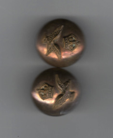
These buttons and lapel wings were issued either by the English Royal Australian Air Force or the Royal Australian Air Force and probably date from pre-World War Two. The Royal Australian Air Force is the aerial section of the Australian Defence Force and was established in 1921. It succeeded the formation of the Australian Flying Corps in 1912. These badges are of interest as early mementoes of the Air Force.1 Two metal badges with raised image of eagle in full flight with a crown above it.They are shank buttons with a connecting link. The eagle is yellow metal with split pin at the rear..1 Buttons J R Gaunt Ltd London.english royal australian air force, australian defence force -
 City of Kingston
Photograph - Black and white, c. 1970
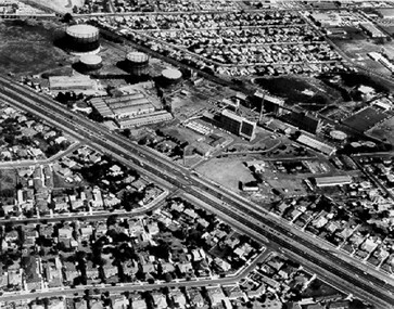
The Highett Gas Works were a landmark along the Nepean Highway for many years. With the cessation of the gasification of coal and the introduction of natural gas to Victoria, the gas holders were demolished and the Sir William Fry Reserve was developed on the southern end of the site. The Gas and Fuel redeveloped the northern end of the site with modern offices and laboratories for the organisation's scientific services. At this time, the chimney and retort house were retained.The Highett Gasworks had its beginning in 1939 operated by the Central Brighton and Moorabbin Gas Co Ltd. The company had expanded its gas production facilities to Highett where it had purchased 45 acres of land adjacent to the Melbourne-Frankston railway line. The first gasholder was erected on the Highett site in 1927 and connected with high pressure mains to the Brighton Gas Works. In 1939 the building program including gasometers, the vertical retort house and coal store was completed and gas making commenced. Its area of supply covered approximately 70 square miles and included the municipalities of Brighton, Sandringham, Moorabbin, Mordialloc, Chelsea and part of Dandenong. The Gas and Fuel Corporation eventually took over operations and with the disaggregation and privatisation of the organisation, the site was eventually closed c. 2002.Black and white aerial photograph featuring the Highett Gas Works with gasholders and retort house. In the top right-hand corner, a former Highett Primary School on Graham Road can be viewed. Photograph includes Bay Road, Royal Avenue, Princess Avenue and Jackson Road (Highett) and Alfred, Turner and Sandford Streets (Moorabbin).Handwritten in black ink: [indecipherable] in a circle Handwritten in red ink: 70% Four velcro display adhesivesgasification of coal, gas and fuel corporation of victoria, gasholders, highett, moorabbin, utilities -
 Port Melbourne Historical & Preservation Society
Photograph - Photocopy, Aerial view, Swallow & Ariell to infilled Lagoon, 1946
Donor was researching property on the corner of Stokes and Graham St, as old timers claim it was "the Nelson Hotel" although there is no record of such in licensing records. Particular building is at upper left of this image.Large photocopy of an aerial photo. 1946 view from Swallow & Ariell to the infilled lagoon and HMAS Barracks. Poor quality image but shows St Joseph's Catholic Church; Holy Trinity; Edwards Park; Lady Forster Kindergarten; Methodist Church on Graham St (no longer there), Bay St. ; three storey Derham houses built environment - industrial, industry - food, swallow & ariell ltd, religion - anglican (holy trinity), religion - wesleyan methodist church, religion - roman catholic church (st josephs), nelson hotel, frederick thomas derham, built environment - domestic, business and traders - hotels -
 National Vietnam Veterans Museum (NVVM)
Photograph, Gibbons, Denis, Nui Thai Van Hills FSB
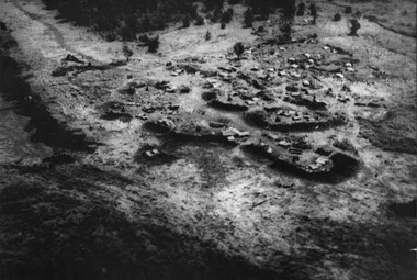
Denis Gibbons (1937 – 2011) Trained with the Australian Army, before travelling to Vietnam in January 1966, Denis stayed with the 1st Australian Task Force in Nui Dat working as a photographer. For almost five years Gibbons toured with nine Australian infantry battalions, posting compelling war images from within many combat zones before being flown out in late November 1970 after sustaining injuries. The images held within the National Vietnam Veterans Museum make up the Gibbons Collection. A black and white photograph of an oblique aerial view of an Australian Fire Support Base at the base of the Nui Thai Van Hills. The FSB provided a battalions direct artillery and mortar support, when on operation away from 1st Australian Task Force Base at Nui Dat, Phuoc Tuy Province. (circa May 1969)photograph, fire support base, 1st atf base, nui thai van hills, gibbons collection catalogue, artillery, mortar, nui dat, phuoc tuy province, denis gibbons -
 Orbost & District Historical Society
road flares, First half 20th century
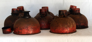
These flares were possibly used during WW11. They were used by Orbost Aero Club at Marlo from 1964 onwards for transporting patients by aerial ambulance to Melbourne. They were placed on the L.H.S. of the runway to indicate wind direction. They were superseded in the late 1970's by pilot activated lighting (PAL) switched on by incoming pilots via radio.These lamps are associated with the history of the Orbost Aero Club.Eight kerosene smudge pot road flares - round metal bases painted red. There is a reservoir at the bottom used for kerosene storage. It was lit at the top for flare.DIETZ . 51 Use Kerosene only Made in U.S.A.lighting kerosene-flares road-flares beacons marlo-airport -
 Bendigo Historical Society Inc.
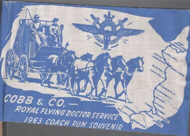
Ephemera - Aileen and John Ellison Collection: Cobb & Co.flag
RFDS was begun by Reverend John Flynn as an aerial Medical Service out of Cloncurry, Queensland in 1928. By 1934 it had expanded across outback Australia. Cobb and Co. was a stagecoach line transporting diggers between the gold fields. There were many coach lines but there names were generalised to "Cobb and Co. It operated between 1853 and 1924.Two small blue and white flag for Cobb & Co. - Royal flying Doctor service 1963 coach run souvenir. The flag has a map of Australia, a horse drawn coach with two men driving, the emblem of the flying doctors and the route from Melbourne to Port Douglas.cobb & co., flying doctors, coach run -
 Bendigo Military Museum
Document - Australian School of Military Survey - Stereotemplets Precis, School of Military Survey, Balcombe, Unknown
A 6 x page foolscap sized precis, two hole punched and stapled produced by the Australian School of Military Survey discusses using Stereo templet triangulation of aerial photography to establish extra supplementary horizontal control positions. Triangulation using Stereo Templates is a method of achieving the horizontal scale solutions required for photogrammetric mapping procedures.A 6 x page foolscap sized precis, two hole punched and stapled. The precis does not have a protective coverNo "61" on the top LH Cornerroyal australian survey corps, rasvy, fortuna, army survey regiment, army svy regt, asr, sms -
 Bendigo Military Museum
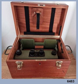
Instrument - Old Delft Scanning Stereoscope ODSS III, C. 1956
This is a superbly crafted cartographic mapping instrument. It is housed in its own high-quality purpose-built oak box. Made in the Netherlands from 1950 onwards. This instrument is from c 1956. it is a very high-quality military grade stereoscope that was generally used by photographic interpreters such as intelligence analysts but was equally useful for mapping activities. The stereoscope was used to examine 3D aerial photographic images. This instrument has a particularly useful capability to scan over the 3D stereo model using X and Y movement knobs, rather than having to physically move the aerial photographs. In the public and private sector it was also useful for photogrammetric interpretation for Forestry and Agricultural purposes. See also Bendigo RSL Collections Victoria item Number 6205.6P that shows the Old Deft Stereoscope in use at the Army Survey Regiment, Bendigo.This is an "Old Delft" scanning stereoscope with its reflecting carriage and legs. The Stereoscope is housed in its own purpose built wooden oak box that has dovetail joints, 2 x securing clips, 2 x handles and a lock (without key). The instrument is assembled by inserting colour coded legs into their matching slots."OLD DELFT SCANNING STEREOSCOPE ODSS III" "Patents Applied for" "OLD DELFT C4790" "MADE IN THE NETHERLANDS"royal australian survey corps, rasvy, fortuna, army survey regiment, army svy regt, asr -
Frankston RSL Sub Branch
Magnifier, Map Reading
A small pocket size folding magnifier used for enlarging detail when reading maps or examining aerial photographs complete with a leather storage pouch. Manufactured of brass by Casartelli of Manchester, England. When unfolded this forms a "U" shape with the glass lens positioned conveniently for map viewing and the base can be used to measure scaled distances.This item is stamped "CASARTELLI, MANCHESTER" and has 1/4, 1/2 and 1 inch markings. -
Glenelg Shire Council Cultural Collection
Banner - Banner - The Heart of our Region, Nov-10
-
Bendigo Historical Society Inc.
Map - FRED COWIE COLLECTION: AERIAL MAPS OF HEATHCOTE/EPPALOCK, 28-9-60
Map, Heathcote C3, Aerial Survey of Victoria, Photo-map prepared by Department of Crown Lands and Survey from photographs taken in 1960.Copied photographically at the Central Plan Office. Date 28-9 60, C.P.O.Neg. No.21588.Campaspe River, Coliban River. Flower Hill. Fred Cowie,46 McIvor Rd.Bendigo (Not located 29.9.2022)Central Plan Office.map -
Port Melbourne Historical & Preservation Society
Pamphlet, West Gate Bridge Progress Report, 1977 - 1979
.04 - .07 ; 4 photocopies of early aerial shots of Kitchens, footy ground and surrounding areas - probably 1920s .08 - Page from Emerald Hills and Sandridge Times 22.02.1979, has two articles (a) relating to Claude Butcher "The last of the clip-clop Milkos". (b) relating to the retirement of the PMCC Electrical Engineer, Jack Andersonengineering - bridges, local government - city of port melbourne, industry - manufacturing, built environment - recreational facilities, built environment - industrial, lower yarra crossing authority, claude butcher, jack anderson, pmcc electricity supply, port melbourne football ground, j kitchen & sons pty ltd, west gate bridge -
 Bendigo Historical Society Inc.
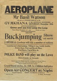
Document - BASIL WATSON COLLECTION: ADVERTISING POSTERS FOR AVIATION DISPLAYS OF B WATSON, 1916- 1917
Collection of advertising posters for aviation displays of Basil Watson: a. ''Aeroplane'' - gymkhana at Aspendale Racecourse, 30th Dec, (1916); b. ''Sensational Aviation'' - general leaflet on Basil Watson with picture of plane; c. ''Aerial Mail'' Mt Gambier to Melbourne includes photo of biplane and Basil Watson; d. ''Sensational Aviation'' Basil Watson is coming.person, individual, basil watson -
Port Melbourne Historical & Preservation Society
Photograph - Aerial view of Port Melbourne, 23 Dec 1945
One of three prints of aerial photographs of Port Melbourne 23.12.1945, showing different areas and to different scales: this one vertical, takes in Station and Town Piers, railyards, Missions to Seamen, Engine Works, temporary US wartime structures, edge of COR buildings, Swallow & Ariell, portion of Wiilliamstown Road. (Smaller copies located in A.06.04.B4)piers and wharves - station pier, piers and wharves - town pier, war - world war ii, built environment, transport - railways, missions to seamen, swallow & ariell ltd -
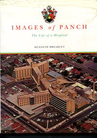 Alfred Hospital Nurses League - Nursing Archive
Book - Illustrated book, Kenneth Brearley, Images of PANCH - the life of a hospital, 1999
A history of the Preston and Northcote Community Hospital, from the initial proposal in 1941 that a hospital be built in Preston, the official opening of the hospital in 1960, until it's closure in1998Illustrated book with dust jacket. Hardcover is bound in red with gilt printing on front (Images of PANCH) and spine (full title and author's name). Dustjacket has a white background, title and author's name on front and spine. Also on front is an aerial photograph of PANCH. On the back cover is the hospital's coat of arms and the words 'Preston and Northcote Community Hospital'non-fictionA history of the Preston and Northcote Community Hospital, from the initial proposal in 1941 that a hospital be built in Preston, the official opening of the hospital in 1960, until it's closure in1998preston and northcote community hospital, hospitals-victoria-history, preaton, panch -
 Bendigo Military Museum
Photograph - Records Hut Personnel – Army Survey Regiment, Fortuna, Bendigo, c1986
These four photos of RaSVY personnel were taken inside the Records Hut, one of Headquarters Squadron’s work areas at the Army Survey Regiment, Fortuna probably in 1986. This building was located near the basketball court and probably at that time, held aerial photography archives, flight planning records, production data folders and final colour separated negatives of published maps.This is a set of two photographs of Records Hut personnel from Headquarters Squadron, Army Survey Regiment, Fortuna, Bendigo, 1986. The photographs were on 35mm negative film and were scanned at 96 dpi. They are part of the Army Survey Regiment’s Collection. .1) - Photo, black & white, 1986, Records Hut – SPR Brett Treneman. .2) - Photo, black & white, 1986, Records Hut – LCPL Bob Sheppard. .3) - Photo, black & white, 1986, Records Hut – L to R: LCPL Bob Sheppard, SPR Brett Treneman. .4) - Photo, black & white, 1986, Records Hut – L to R: LCPL Bob Sheppard, SPR Brett Treneman.No personnel are identifiedroyal australian survey corps, rasvy, army survey regiment, army svy regt, fortuna, asr -
 City of Kingston
Photograph - Black and white, 20 December 1945
Cheltenham is a suburb in the City of Kingston that was originally established as a rural market gardening community. The area is bordered by Highett, Mentone and Heatherton. The market gardens, farms and paddocks have gradually been sub-divided into housing and industrial estates. The Southland shopping centre is a major feature of the area.Cheltenham was established as a rural market gardening community. The Le Page family lived in Cheltenham since 1854 when Nicholas Le Page, a tailor from the Channel Island of Guernsey, bought two acres of land on Chesterville Road near Bernard Street to establish a market garden. Over the years the Le Pages purchased more land in the area. In 1875-76 Nicholas' son Frank and his wife Mary built 'Daphne Cottage' near the corner of Bernard and Wilson Streets. n the 1940s Frank's son, Everest Le Page, bought five more lots of land in Chesterville Road from the Tuck family. The Le Pages grazed horses, ponies and cows on this land, and grew pumpkins, carrots, parsnips, onions, potatoes and cabbages. Many buildings and locations within in Cheltenham commemorate the Le Page family's contribution to the Cheltenham community.Aerial photograph taken in 1945 of the Cheltenham district within the City of Kingston. The image includes Chesterville Road, the future site of Turner Road pool (now Waves) and Highett Reserve, (top left), Jellicoe Street, Argus Street, Bernard Street, Wilson Street, the Methodist Children Homes (now Southland), McIvor Street, Goulburn Street, Nepean Highway, Jamieson Street and Barker Street (bottom left), market gardens and paddocks. In the top centre of the image, "Daphne Cottage", the home of Frank T. Le Page is visible on the corner of Bernard and Wilson Streets. Much of the land depicted in this image was owned by the Le Page family. This image is possibly from the collection of aerial photographs commissioned by the Department of Crown Lands and Survey and taken by Adastra Airways.Black and white ink: 57250 White print: VIC-170 57250 20.12.45 Run 6 PROJ. No. 5 MELB. METROP AREA Black type 10200 FTS 30' LENS 20.12.45cheltenham, market gardens, industry, le page family -
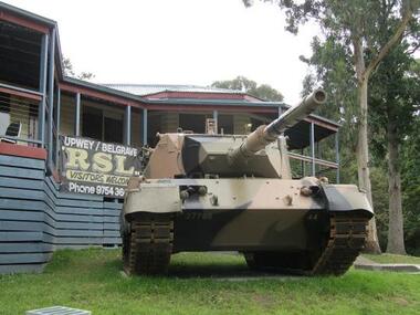 Running Rabbits Military Museum operated by the Upwey Belgrave RSL Sub Branch
Leopard Tank, Krauss-Maffei Wegmann GmbH & Co KG, Leopard Tank ARN 27765, 1970
The tank provides heavy and direct firepower against enemy targets. Its main armament is a 105mm gun which can fire high explosive, armour-piercing, anti-personnel and smoke ammunition. The main gun can engage a pin point target at distances up to 2500m and area targets up to 8000m As with other members of the Leopard family, the gun tank is powered by a V-10 four stroke, supercharged diesel engine developing 610kW. It has a maximum speed of about 62km/h and can "snorkel" through water. These tanks were never used outside Australia and have never been used in combat.Crew 4: Crew Commander, Gunner, Operator, Driver Engine MTU supercharged V-10, (37.4 litres) Fuel Capacity 985 litres Hull Armour 70mm Turret Armour Classified Main Armament L7A3 105mm rifled gun Length 9.54m (with gun in combat position) Width 3.37m Height 2.62m (4.8m with radio aerials) leopard tank -
Glenelg Shire Council Cultural Collection
Banner - Banner - Tomorrow's Possibilities, Nov-10
-
 Warrnambool and District Historical Society Inc.
Book, Warrnambool Botanic Garden Masterplan, February 1995
This Warrnambool Botanic Gardens Study and Report was funded by the National Estate Grants Program of the Australian Heritage Commission and the City of Warrnambool. It was monitored in progress by a Steering Committee consisting of representatives of the Botanic and Public Gardens Advisory Committee, the Warrnambool City Council, Friends of the Warrnambool Botanic Gardens and National Estate Grants Program representatives and community representatives. The Warrnambool Botanic Gardens were first sited close to the Hopkins River in 1859. In 1869 the gardens were relocated to the present day location in Botanic Road. This plan is of some importance as it gives an overview of the history and current condition in 1995 of the Warrnambool Botanic Gardens and draws up a plan for its future development. It is useful for research and for consideration by the City Council today of policy making and further development of the gardens. This is a publication containing a master plan for the Warrnambool Botanic Gardens. It has a section on acknowledgements, a summary, eight chapters, and 14 appendices. The pages are bound with plastic rings, the front cover is plasticized with an aerial photograph of the Botanic Gardens and surrounds and the back cover is lightweight cardboard. The pages contain printed material, fold out maps, sketches and diagrams and many photocopied photographs.Front Cover: City of Warrnambool, Warrnambool Botanic Gardens, Conservation and Development Plan, Jill Orr-Young, Patrick Mallon, SF Consultants Pty Ltd, February 1995. warrnambool botanic gardens, warrnambool -
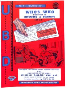 Ringwood and District Historical Society
Booklet, UBD Directory of Ringwood & Districts 1961-62
A Universal Business Directories Publication. Contains: Numerous advertisements by local business Summary of Ringwood services groups, wards, parks, schools, councillors, etc Doctor's Surgeries Index of streets Aerial maps Lists of businesses by business categories Includes the same for Croydon, Lilydale, Heathmont and Kilsyth. Some small business lists for Warrandyte, South Warrandyte, Vermont and Montrose. -
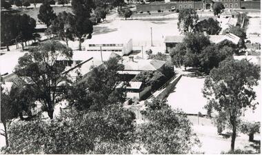 Bendigo Historical Society Inc.
Photograph - LA TROBE UNIVERSITY BENDIGO COLLECTION BENDIGO: TEACHERS' COLLEGE BUILDINGS
A black and white photograph of an aerial view from the Lookout Tower in Rosalind Park of Bendigo Teachers' College as it was in the 1950's. In the foreground are aluminium prefabs and the old police stables. In the background is the old gaol and over to the left are the tennis courts which appear to have the sprinklers on. Although it is out of view Camp Hill Primary School is on the right of the buildings. 1950's.bendigo, education, bendigo teachers' college, la trobe university bendigo collection, collection, education, tertiary education, bendigo, bendigo teachers' college, place, buildings, bendigo gaol, tennis courts, gaol, photo, photograph, photographs, photography -
 Bendigo Historical Society Inc.
Photograph - BENDIGO SCHOOL OF MINES, c.1900
Black and white photograph showing façade of Bendigo School of Mines and the Mechanics Institute from North. Gas lamp opposite front gate. Radio aerial on roof. Photo is copy of original. On back: stamped in circle 'Royal Historical Society of Victoria, Bendigo Branch'. In black ink - '257'. In blue ink - '6', 'Now, FSP, 1204', Aeritrew?buildings, commercial, school of mines -
 Bendigo Historical Society Inc.
Photograph - 1.25,000 BENDIGO AERIAL PHOTOGRAPHS
Eighteen undated coloured 1.25,000 army aerial photographs covering Bendigo city and district. [a] -( Similar to A vintage Abrams map reader -Adjustable Stereoscope) -Casella London viewing eye frame with Irving scratched into frame. Another name scratched out also. [b] WW2 Leather pouch stamped Casella London made to hold eye frame.bendigo, utilities, fortuna army mapping division -
Port Melbourne Historical & Preservation Society
Newspaper - Newspaper, The Australasian Centenary Number Newspaper, Victoria's 100th Anniversary, "The Australasian Centenary Number Newspaper", 18 Oct 1934
"The Australasian Centenary Number Newspaper" produced for Victoria's 100th anniversary in 1934. Large 72 page supplement. Full colour front and back covers plus 2 pages in text, one colour elsewhere including centre spread aerial photo "The Village, 1934". Contains comprehensive history dating from 1770, many ads. Lavishly illustratred.At top front page in ink "E.S McCallum, Graham St, Port Melbourne"arts and entertainment, religion, transport - shipping, transport - railways, industry, built environment, publishing, newspapers, the australasian, hrh prince henry, duke of gloucester, gold, celebrations fetes and exhibitions, e s mccallum, john batman -
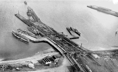 Port Melbourne Historical & Preservation Society
Photograph - Aerial view during construction of Station Pier, Port Melbourne, c. 1925
Aerial photo showing the double-headed pier created by partially dismantled Railway Pier and partially built Station Pier, late 1920s. Also the new wing piers with paddlesteamers Hygeia, Weeroona and Ozone (latter being broken up), foreshore and railyards, and end of Princes Pier. Pasted on A4 paper printed with computer generated chequered border.transport - shipping, piers and wharves - station pier, piers and wharves - railway pier, ps weeroona, ps hygeia -
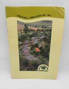 Hume City Civic Collection
Annual Report, Shire of Bulla: Annual Report, 1993 - 1994
The 1993 - 1994 Annual Report was published by the Shire of Bulla and distributed to the residents of the shire.A 24 paged publication with a yellow cardboard cover which has an aerial photograph which features the former Sunbury Asylum buildings and surroundings before the area was developed for housing. The former Shire of Bulla logo which featured 'City Living - Country Style' is in the bottom RH corner of the photograph. Details of the administration officxes of the Shire of Bulla are printed on the back cover.shire of bulla, annual reports, councillors, george evans collection -
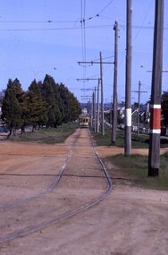 Ballarat Tramway Museum
Slide - 35mm slide/s - set of 3, Mark Plummer, Sep. 1971
Series of three photos of Ballarat No. 17, northbound or inbound in Albert St. Sebastopol, approaching the Ophir St. crossing of Albert St. Note tram stop signs, aerial phone lines, the condition of the track and the gravel crossings. Tram has the destination of Lydiard St. North. Kodak cardboard mount slide, taken Mark Plummer, September 1971tramways, trams, albert st, sebastopol, ophir st, tram 17 -
![Plan, University of Melbourne Burnley Campus Institute of Land and Food Resources Formerly known as the Royal Horticultural Gardens Burnley [sic], 2001](/media/collectors/52f2d90c9821f4163875a333/items/6145823c174069677c22f6e6/item-media/65ef8feeb2201fddf6999498/item-fit-380x285.jpg) University of Melbourne, Burnley Campus Archives
University of Melbourne, Burnley Campus ArchivesPlan, University of Melbourne Burnley Campus Institute of Land and Food Resources Formerly known as the Royal Horticultural Gardens Burnley [sic], 2001
site plan, buildings, planrs -
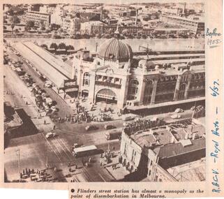 Melbourne Tram Museum
Document - Illustration/s, Royal Automobile club of Victoria (RACv), Jun. 1957
Illustration from the RACV Royal Auto magazine of June 1957 of an aerial view of Flinders St Station and buildings on the south side of the Yarra River, showing motor cars, trams and one bus. Also possibly shows the curve from Swanston St into Flinders St. Caption: "Flinders street station has almost a monopoly as the point of disembarkation in Melbourne"In ink on the side" "RACV - Royal Auto - 6/57 Before 1955"trams, tramways, flinders st station, swanston st