Showing 10715 items matching "east melbourne"
-
 Eltham District Historical Society Inc
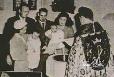
Photograph, A Baptism, conducted by the Reverend David Warren (1956-1960) wearing vestments, Vicar of St Margaret's, c.1960. The font is located in the south-east corner of the church
Digital scan of photograph - Original Source Copy: St Margaret's Parish Archives. church of england, churches, eltham, st margarets church, reverend david warren -
 Eltham District Historical Society Inc
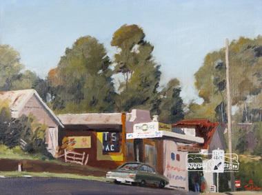
Photograph, Ted Dalton, The Corner Store, Ted Dalton, c.1980, 1980c
View of the old Burgoyne store looking south-east across Main Road, Eltham near the intersection with Bridge Street.Digital scan of painting c.1980 oil on board 44.5 x 59.5 cm signed lower rightburgoyne store, eltham, main road, ted dalton -
 Eltham District Historical Society Inc
Photograph, Peter Bassett-Smith, Construction of Eltham Community Centre, June 1977, 1977
Looking east from the Eltham Community Centre to Main Streeteltham, eltham community centre, buildings, construction -
 Eltham District Historical Society Inc
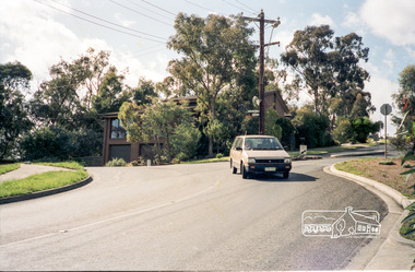
Photograph, Cooinda Reserve, cnr Grove and Beard Streets, Eltham
Roll of 35mm colour negative film, 5 of 7 stripsKodak GA 100 5095shire of eltham, roads, cooinda reserve, eltham east, beard street, grove street -
 Eltham District Historical Society Inc
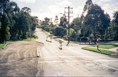
Photograph, Intersection of Grove Street, Beard Street and Wycliffe Crescent, Eltham
Roll of 35mm colour negative film, 5 of 7 stripsKodak GA 100 5095shire of eltham, roads, eltham east, beard street, grove street, wycliffe crescent -
 Eltham District Historical Society Inc
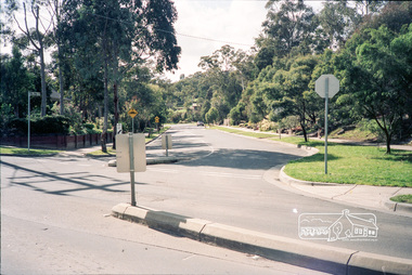
Photograph, Intersection of Beard Street and Valonia Drive, Eltham before the roundabout
Roll of 35mm colour negative film, 5 of 7 stripsKodak GA 100 5095shire of eltham, roads, eltham east, beard street, valonia drive -
 Eltham District Historical Society Inc
Photograph, Intersection of Beard Street and Valonia Drive, Eltham before the roundabout
Roll of 35mm colour negative film, 5 of 7 stripsKodak GA 100 5095shire of eltham, roads, eltham east, beard street, valonia drive -
 Eltham District Historical Society Inc
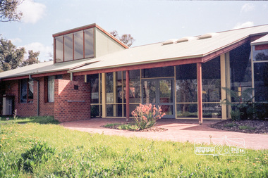
Photograph, Eltham Woods Childcare Co-operative, Frank Street, Eltham, c. Oct 1987, 1987
Roll of 35mm colour negative film, 5 of 7 stripsKodak GA 100 5095shire of eltham, eltham east, eltham woods childcare co-operative, frank street -
 Eltham District Historical Society Inc
Photograph, Eltham Woods Childcare Co-operative, Frank Street, Eltham, c. Oct 1987, 1987
Roll of 35mm colour negative film, 5 of 7 stripsKodak GA 100 5095shire of eltham, eltham east, eltham woods childcare co-operative, frank street -
 Eltham District Historical Society Inc
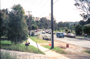
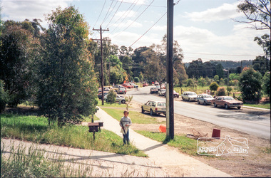
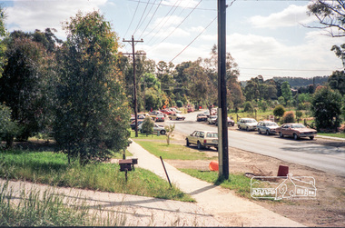
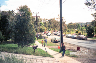
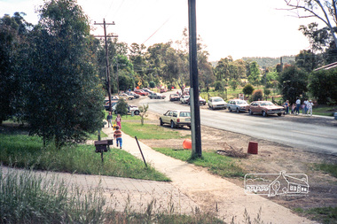
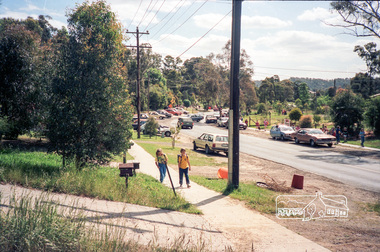
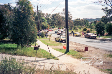
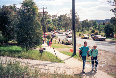
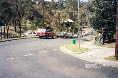
Photograph, School pick-up traffic from Eltham East Primary School, Grove Street, c.April 1987
Probably a Shire of Eltham investigation into traffic and parking at school pick-up timesRoll of 35mm colour negative film, 3 stripsKodak GA 100 5095shire of eltham, eltham east primary school, roads, grove street -
 Eltham District Historical Society Inc
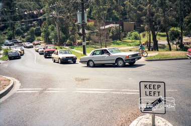
Photograph, School pick-up traffic from Eltham East Primary School, Beard Street, c.April 1987
Probably a Shire of Eltham investigation into traffic and parking at school pick-up times At the junction of Grove and Beard Streets viewed from Wycliffe CrescentRoll of 35mm colour negative film, 3 stripsKodak GA 100 5095shire of eltham, eltham east primary school, roads, grove street, beard street, wycliffe crescent -
 Eltham District Historical Society Inc
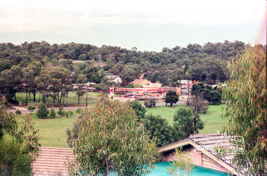
Photograph, View from the vicinity of Leanne Drive of the Food Plus Service Station at corner of Beard Street with Main Road, Eltham East, c.1987
Roll of 35mm colour negative film, 7 stripsKodak GA 100 5095roads, main road, beard street, bp service station, eltham east, food plus, leanne drive -
 Eltham District Historical Society Inc
Photograph, Looking east adjacent to 13-17 Piper Crescent, Eltham, c.1988
Roll of 35mm colour negative film, 1 stripKodak GB 100 5096shire of eltham, roads, piper crescent -
 Eltham District Historical Society Inc
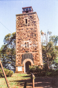
Negative - Photograph, Russell Yeoman, Shire of Eltham War Memorial, Memorial Park, Garden Hill, Eltham-Yarra Glen Road, Kangaroo Ground, c.1980
Shire of Eltham War Memorial Tower at Kangarooo Ground; view from the east and close up of entrance including Honour Roll. On November 11th 1926 the Shire of Eltham War Memorial Tower at Kangaroo Ground was opened. It is regarded as one of Melbourne’s most outstanding lookout towers. It commands a magnificent 360 degree panorama from Kinglake across the Diamond Valley to Macedon and the You Yangs. It is built on a peak which was once a volcano, 237 metres above sea level. After World War one a memorial cairn was erected on the site, and in 1925 a committee of public-minded citizens began to plan for a tower. Many generous donations of material and money were forthcoming so that in 1926 the Governor General Lord Stonehaven was able to unveil the plaque before a crowd of 500 people There was some concern in the 1960s when the Forests Commission wanted to build a firespotters cabin on the top. At first R.S.L. branches opposed the idea, but it was realised that this use could combine with its use as a tourist attraction, and would ensure its maintenance for the future. Today the Kangaroo Ground tower provides one of the best views around Melbourne and is a fitting memorial to those who died in two world wars. From: Historic items for Diamond Valley Community Radio September 1990 (EDHS collection) On November 8th, 1951, the memorial was re-dedicated by the Governor of Victoria, Sir Dallas Brooks with the addition of the names of men from the Shire of Eltham who fell in the Second World War. Further wreaths were added subsequent to this image in time for the 2001 Reembrance Day service to commemorate the men from th shire who had fallen in the Malayan, Korean, Borneo and Vietnam campaigns.Roll of 35mm colour negative film, 2 strips Colour print (x1)Kodak Safety 5035garden hill, kangaroo ground, kangaroo ground memorial, memorial park, shire of eltham war memorial tower, war memorial, garden hill, kangaroo ground, kangaroo ground memorial, kangaroo ground relief committee, memorial park, shire of eltham war memorial tower, war memorial, shire of eltham war memorial -
 Eltham District Historical Society Inc
Photograph, Monash Bridge, Arthurs Creek Road, Hurstbridge, Eltham Heritage Tour, 24 May 1992, 24/05/1992
ELTHAM HERITAGE TOUR The Society excursion on 24th May 1992 was arranged by David Bick, leader of the team carrying out the Shire's heritage study. David selected a number of sites or buildings identified in the study, some of them lesser known components of the Shire's heritage. The tour commenced at the Eltham Shire Office at 10.00 am. Travel was by private car and mini-bus with stops at about twelve locations for commentary by David.It included a short walk in Hurstbridge and lunch at Kinglake. Highlights of the tour included: - 10 am Leave from Shire Offices - 3 Important Trees - A Physical Link to Eltham's First Settlers - Toorak Mansion Gates - A Surviving Farm House - An Intact Circa 1900 Main Street - First Settlers - Gold Miners, and Timber-getters - An Early Hotel - A Pioneering Homestead - Changing Eltham Shire - 20th Century - 4 pm Afternoon Tea and Finish Tour Extract from ELTHAM CULTURAL HERITAGE TOUR (Newsletter No. 85, July 1992, by Bettina Woodburn) "On the Arthurs Creek Road is a bridge designed by Monash, which we admired before walking across the little park with a mud-brick and timber shelter, to the Hurst family graveyard. There are two marked graves, one, Henry who was shot by Burke the bushranger and a cairn has a plaque listing others buried here from 1866 onwards. Burke was captured and tied to the wheel of a dray under the eucalypt near the waterhose/standpipe. Close by the kindergarten, at this place are three trees on the National Trust Register, a Canary Island pine, a Canadian cedar and probably a spruce. Radiata pines and a thick bolled peppercorn surround the little cemetery. Continuing along Main Street we notice elm trees planted as a war memorial, then on the left a 1930 timber house, a 1910 store and residence, resplendent with wrought iron trim, a double fronted Hardware Store and cypresses on the back alignment of a new vacant block. On the right side of the street is a less interesting attempt at an 'in character' shop. Further on are more early homes, one tucked away at the rear with two tall palms by the front steps. Another curiosity is a rounded veranda corner and there are more galvanised iron sheds or garages, before a mud-brick Dentist's Surgery. Beyond the round-a-about is St Peters Church, of mud-brick construction shared by Catholic and Anglican parishioners, overlooking the river flood plain. Leaving Hurstbridge on the Kinglake Road, we ate our picnic lunch beside the communication tower and enjoyed views of Melbourne, Yan Yean Reservoir and the distant Dandenongs beyond the spreading suburbs. Next we drove to the North West boundary of the Shire at Masons Falls Road towards Whittlesea. On the way to the North East Boundary we passed St Peters, a yellow wooden Church with a Tudor Archway; built in the early 1920's in the style of the 1860's. From the Healesville-Kinglake road the rolling hills had European aspects, the hedged fields and chestnut trees. Then it was back down the Hurstbridge Road through 'Aussie' bush of towering gums, with bracken and scrubby understorey, the Kinglake National Park, before more open country with deciduous trees planted in line, and a creek lined with willows."Record of the Society's history and activities and highlighting various aspects of the Heritage Study undertaken by David Bick used to create the future heritage overlay for the Shire of Eltham and later Nillumbik Shire.Roll of 35mm colour negative film, 4 stripsKodak Gold 100 5095shire of eltham historical society, activities, heritage tour, hurstbridge, monash bridge, arthurs creek road -
 Eltham District Historical Society Inc
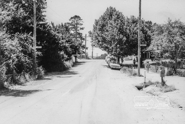
Photograph, Looking North along Main Road near intersection with John Street, Eltham, February 1968, Feb 1968
Shows cars parked outside Burgoyne's store on the east side In February 1968 an unknown person took a series of photos from the Eltham Hotel at Pitt Street heading north along Main Road through the shopping centre to just north of Elsa Court covering the length of the section of Main Road which was duplicated shortly thereafter. Shows the condition and environment of the streesscape of Main Road, Eltham immediately prior to the duplication between Pitt Street and Elsa Court through the shopping centre. Also shows a number of shops and businesses that operated at that time.Black and white photographduplication, eltham, main road, burgoyne's shop, john street -
 Eltham District Historical Society Inc
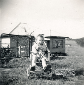
Photograph, View across 36 Beattie Street, Montmorency built by Stan Rushbrook looking south east. John Landy approx 1 year old, c.1952, 1952c
Digital copy of black and white photograph38 beattie street, montmorency, john landy, stan rushbrook -
 Eltham District Historical Society Inc
Newsletter, Newsletter, No. 218 September 2014
Contents: • Eltham Living and Learning Centre • September Meeting • September Excursion - East of Eltham Walk • Have you discovered Trove? by Liz Pidgeon • Fabbro Farm Art Project • Eltham Library - 20th Anniversary Celebration • Henry Gilbert Jones: an early Eltham settler........and an amazing coincidence by Michael Aitken • Street by Street The Shire of Eltham Historical Society was formed in October 1967. The first newsletter of the Society was issued May 1978 and has been published continuously ever since on a bi-monthly basis. With the cessation of the Shire of Eltham in late 1994, the Society's name was revised to Eltham District Historical Society and this name first appeared with issue No. 103, July 1995. The collection of the Society's newsletters provides a valuable resource on the history of the Society's activities, office bearers and committee members, guest speakers and subjects of historical interest pertinent to the former Shire of Eltham and the Eltham District.A4 photocopied newsletter distributed to membersnewsletter, eltham district historical society, shire of eltham historical society -
 Eltham District Historical Society Inc
Photograph, Liz Pidgeon, Heritage Excursion; East of Eltham, 6 Sep 2014, 20 May 2017
Newsletter No. 218, September 2014 September Excursion - East of Eltham Walk In Newsletter No. 197, March 2011, there was a brief history of Crown Allotment 15 Section 5 Parish of Nillumbik (CA 15) a parcel of land of a quarter of a square mile extending from Eucalyptus Road to Reynolds Road at the eastern extremity of Eltham. From the 1940s it was known as Stokes orchard. In later years it has been subdivided for residential purposes but leaving significant areas as power line and water supply reserves and bushland reserves that are habitat for the threatened For our excursion on 6th September we intend to walk through CA 15 to a bushland reserve east of Reynolds Road. The walk will traverse the boundary between suburban Eltham and the non-urban areas to the south and east. This is a pleasant walk through residential areas and bushland. Along the way we will discuss the early and more recent history of CA 15 as well as local natural history and geology. This walk is about 3.5 km in length and will take 2 to 2.5 hours. It will start at 2pm at the corner of Eucalyptus Road, Pitt Street and Nyora Road.Born Digitaleltham east, eltham district historical society, heritage excursion, activities, nyora road, reynolds road, gum tree road reserve, diosma road, stokes orchard, eucalyptus road -
 Eltham District Historical Society Inc
Photograph, Liz Pidgeon, Heritage Excursion; East of Eltham, 6 Sep 2014, 20 May 2017
Newsletter No. 218, September 2014 September Excursion - East of Eltham Walk In Newsletter No. 197, March 2011, there was a brief history of Crown Allotment 15 Section 5 Parish of Nillumbik (CA 15) a parcel of land of a quarter of a square mile extending from Eucalyptus Road to Reynolds Road at the eastern extremity of Eltham. From the 1940s it was known as Stokes orchard. In later years it has been subdivided for residential purposes but leaving significant areas as power line and water supply reserves and bushland reserves that are habitat for the threatened For our excursion on 6th September we intend to walk through CA 15 to a bushland reserve east of Reynolds Road. The walk will traverse the boundary between suburban Eltham and the non-urban areas to the south and east. This is a pleasant walk through residential areas and bushland. Along the way we will discuss the early and more recent history of CA 15 as well as local natural history and geology. This walk is about 3.5 km in length and will take 2 to 2.5 hours. It will start at 2pm at the corner of Eucalyptus Road, Pitt Street and Nyora Road.Born Digitaleltham east, eltham district historical society, heritage excursion, activities, nyora road, reynolds road, gum tree road reserve, diosma road, stokes orchard, eucalyptus road