Showing 19894 items
matching east-malvern
-
 Eltham District Historical Society Inc
Photograph, Liz Pidgeon, Heritage Excursion; East of Eltham, 6 Sep 2014, 20 May 2017
Newsletter No. 218, September 2014 September Excursion - East of Eltham Walk In Newsletter No. 197, March 2011, there was a brief history of Crown Allotment 15 Section 5 Parish of Nillumbik (CA 15) a parcel of land of a quarter of a square mile extending from Eucalyptus Road to Reynolds Road at the eastern extremity of Eltham. From the 1940s it was known as Stokes orchard. In later years it has been subdivided for residential purposes but leaving significant areas as power line and water supply reserves and bushland reserves that are habitat for the threatened For our excursion on 6th September we intend to walk through CA 15 to a bushland reserve east of Reynolds Road. The walk will traverse the boundary between suburban Eltham and the non-urban areas to the south and east. This is a pleasant walk through residential areas and bushland. Along the way we will discuss the early and more recent history of CA 15 as well as local natural history and geology. This walk is about 3.5 km in length and will take 2 to 2.5 hours. It will start at 2pm at the corner of Eucalyptus Road, Pitt Street and Nyora Road.Born Digitaleltham east, eltham district historical society, heritage excursion, activities, nyora road, reynolds road, gum tree road reserve, diosma road, stokes orchard, eucalyptus road -
 Ringwood and District Historical Society
Map, Ringwood Croydon Mail, Map of East Ringwood with numbered sites of interest published by the Ringwood Croydon Mail for Ringwood Secondary College Fire Appeal Fund. 1993, 16-Sep-93
Map of East Ringwood with numbered sites of interest published by the Ringwood Croydon Mail as the major sponsor for Ringwood Secondary College Fire Appeal Fund. The school was extensively burnt in a fire in 1992 which destroyed classrooms, records, musical and sports displays.White sheet of paper with brown printing, A3, with marked locations for visiting. -
 Ringwood and District Historical Society
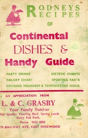
Booklet, Grasby, L. and C, Rodney's Recipes of Continental dishes and Handy Guide. From Your local Butcher (East Ringwood) c1960, c1960
Given to customers of L. and C. Grasby, Your Family Butcher, 78, Railway Avenue, East Ringwood.Roney's Recipes of Continental Dishes and handy Guide of party drinks, calorie chart, dietetic charts, sporting facts, cooking measures and temperature guide.10 page booklet plus cream coloured covers with red and green printing on both sides. Contains recipes for various occasions, drinks, charts, cooking measures and temperature guide. Covering letter from Mrs. Ives +Additional Keywords: Grasby / Ives, Mrs. Norma -
Stawell Historical Society Inc
Photograph, Upper Main Street Reefs looking East towards Big Hill looking from the front of Joyce's Hibernian Hotel 1866
Upper Main Street Reefs looking East towards Big Hill taken from front of Joyce's Hibernian Hotel . Part of a collection of Photographs by Mr. O.G. Armstrong as commissioned by the Shire of Stawell for the Inter-colonial and Paris Exhibition in Melbourne in 1866.stawell streetscape -
 Stawell Historical Society Inc
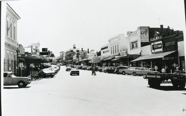
Photograph, Main Street Stawell looking East from Wimmera Street
Stawell Main Street looking East from Wimmera Street. Post office on left Toy Shop on right Bull & Mouth in Centre. Vehicle entering intersection from left and angle parked in Street. Two people crossing road at centre.stawell streetscape -
 Surrey Hills Historical Society Collection
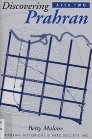
Book, Discovery Prahran - Area Two, 1999
This booklet provides a general picture of Prahran as it developed from the first Crown land sales of 1840 to its amalgamation with the City of Malvern in 1994This booklet provides a general picture of Prahran as it developed from the first Crown land sales of 1840 to its amalgamation with the City of Malvern in 1994prahran (vic) - history, toorak (vic) - history, armadale (vic) - history, (ms) betty malone -
Ringwood and District Historical Society
Newspapers, Croydon and Ringwood Post, Ringwood East Primary School: Cuttings with photos of students in Ringwood Lake. 1986. Also Pump Family in Ringwood Square Chronicle 1988, 1986-1988
3 extracts from newspapers with pictures of students from Ringwood East Primary School at the Ringwood Lake. Also in the first edition of the Ringwood Square Chronical, a picture of the Pump family. One of the girls was the first teacher at the school when she grew up.3 extracts from newspapers; The Post 26-Aug-1986 front page with photo; 2-Sept-1986, page with pictures "Schools in at the Lake"; Ringwood Square Chronical Vol 1 No 1 June 1988 -
 Ringwood and District Historical Society
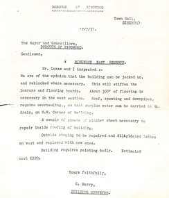
Administrative record - Borough of Ringwood 17/7/51 report to Mayor and Councillors, Document from C Merry, Building Surveyor Ringwood East Reserve
Building report Ringwood East Reserve from C Merry, Building Surveyor and Mr Lucas to the Mayor and Councillors Borough of Ringwood 17/7/51. Building can be jacked up and reblocked where necessary. 300' of flooring is necessary in the west section. Roof, spouting and downpipes require overhauling. Needs some repair work inside and outside. Estimated cost 220 pounds.