Showing 3393 items matching "roofs"
-
 Surrey Hills Historical Society Collection
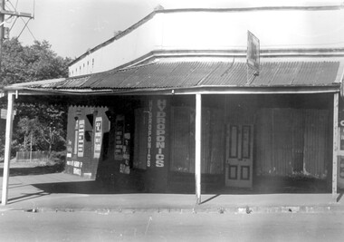
Photograph, 109 Union Road, Surrey Hills after fire damage
This building was damaged by fire and was subsequently demolished before June 1983. From 1901-1917 it was the site of the Surrey Hills Post Office. In later years the part of the building with frontage to Windsor Crescent was used as the dental surgery of Dr David Ellis; the Union Road part of the building was occupied by a barber and tobacconist for many years. At the time of the fire the building was used by a business supplying hydroponics requirements. This moved to (?) 119 Highbury Road, Burwood.The image is significant because it documents a building which was an important community facility which no longer exists.Black and white photo of a single-storey corner building with a corrugated iron roofed veranda and a single, 4-panel timber door. There is a sign with '109' mounted on the veranda of the building. There are multiple advertising signs on the walls of the building. Two of the windows are boarded up with corrugated iron sheets.shops, barber shops, tobacconists, surrey hills post office, dentists, union road, windsor crescent, hydroponics supplies, businesses, union road shops, dr david ellis -
 Surrey Hills Historical Society Collection
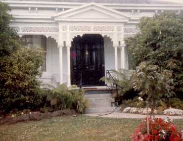
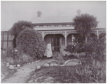
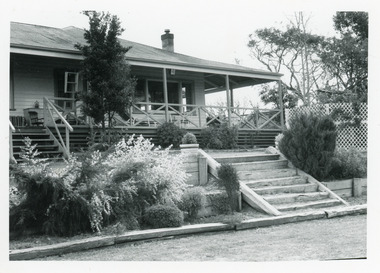
Photograph, 101 Guildford Road, Surrey Hills
The house was built in 1883, possibly to encourage development of housing on the first urban land subdivision in Surrey Hills, the Windsor Park Estate (in the Windsor Crescent area). This coincided with the opening of the Surrey Hills Railway station. The first occupant was John Brown Nicholson, police magistrate. In 1884 the foundation meeting of the Wyclif Congregational Church was held in the house.Colour photo of the front door and verandah of 101 Guildford Road taken from the street. The house is Victorian in style with ornate lacework along the verandah. It is painted white and has a slate roof. There is a well-maintained garden with flower beds and shrubs, which partially obscure the house.victorian style, wyclif church, houses, guildford road, john brown nicholson -
 Surrey Hills Historical Society Collection
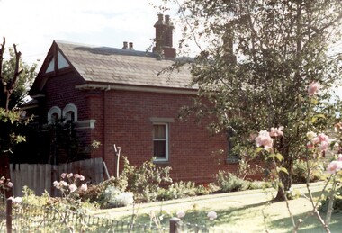
Photograph, Tavistock at 192 Union Road, 1978
The date is approximate. Tavistock was built c1890. The side windows on the front room are a later addition in a different style from the original windows. In 1897 it was the home of the Walker family; Joyce Walker later became matron of Mosgiel Hospital. In 1902 it became the first site of Milverton Girls School. From 1930s to 1960s it was home to Miss Marjorie Vahland, a locally well-known nursing sister. See History Walks No 5, p 11 and p32 Surrey Hills In Celebration of its Centennial 1883-1983Colour photo of the north side of Tavistock at 192 Union Road, Surrey Hills revealed when this side of the property was partially without a fence; taken while re-fencing. The house is Victorian in style, of red brick construction with a patterned slate tile roof and decorative chimneys.tavistock, milverton girls school, victorian style, houses, joyce walker, miss marjorie vahland, nurses -
 Lakes Entrance Historical Society
Photograph, 1999
Some of the proprietors - Jessie and Alfred Ilton, Jack Bills Philip, Isabel Smith, Stanley and Isaha Rena Russell,Colour photograph of a dwelling at 9 - 11 Old Buchan Road, showing a weatherboard building with corrugated iron gable roof, veranda across half front of front entry. Now private residence, was boarding house from 1917c to 1950's. Nowa Nowa Victoriabuildings, retail trade -
 Linton and District Historical Society Inc
Photograph, Adams House, Grey Street, Linton
From the "Walk-Drive Tour of Linton", p. 22: ". . . this large Victorian house was originally the home of Hubert Adams, the proprietor of the Grenville Standard from about 1895 until 1909. It was subsequently purchased by the Shire of Grenville and was for many years the Shire Engineer's home." The inscription on the front of one of the copies says the photo was taken c. 1890.Photograph of a timber Victorian style house with a corrugated iron roof. The house has two chimneys and wrought iron decoration on the verandah. An unidentified woman and a young girl are standing in the garden at the front. Adams house, afterwards used as Shire Engineer's house, in Grey Street, LintonOn front of both copies: Shire Engineer's House, Grey St. Linton". On front of copy (a): "c. 1890". On back of copy (b): Shire Engineer's House Grey St Linton".houses, buildings, adams house, shire engineer's house -
 Bendigo Historical Society Inc.
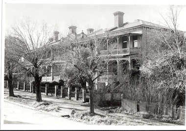
Photograph - BENDIGO: HUSTLERS TERRACE, 1965
black and white photo: houses, terrace, 3 storeys, iron lace, 6 chimneys visible. Fence brick pillars with iron rods vertically between pillars. Parapet at centre on roof. 'Hustlers Terrace/FSP Barkley Place/1204 ( opp. Convent ) 'Hustlers Terrace'A. Doneycottage, miners -
 Bendigo Historical Society Inc.
Photograph - T C WATTS & SON - 36 HOPPER STREET, 1927
BHS CollectionBlack and white photograph mounted on rectangular grey board. House, weatherboard, small section of render above window, corrugated iron roof, leadlight windows. Verandahs L and R, that on the R filled in, 4 chimneys, decorative woodwork under the windows. 36 Hopper Street.Frank A. Jeffree, Bendigoplace, building, residential, stamped on back ''t.c. watts and son'' stamped on back in circle ''royal historical society of victoria, bendigo branch'' -
 Lakes Entrance Historical Society
Photograph - Housing, 1980
Built post WW2 as home for Rev Canon Albert E Clark. The decorative brick and stone work on house and in garden built by Canon Clark with assistance of wife and daughter Ruth. Ruth Clark, noted botanist, with particular interest in the ground orchids of East Gippsland, continued living here until her death in Septemebr 1997.Colour photograph of a timber dwelling. Tiled gable roof, sash windows, decorative stone work on chimney, base of house, veranda, paths, garden and front fence. Attractive wrought iron railings atop stone fence, at 7 Williams Road, Lakes Entrance Victoriafences, houses, heritage study -
 Lakes Entrance Historical Society
Photograph - Housing, 1991
Date made September 1991Black and white photograph of a timber residence with corrugated iron roof, six wide steps leading from shaded veranda, native plant garden in narrow terrace with sleeper steps leading down to mowed lawn. Situated at Mill Point Road, Toorloo Arm Victoriahouses, timber industry, heritage study -
 Bendigo Historical Society Inc.
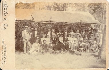
Photograph - GROUP PHOTO IN BUSH, approx. 1900
Sepia photograph mounted on fawn board. Group photo - 3 rows of men and woman in front of building with canvas roof. Branches from eucalypts leaning against structure. Men are dressed in suits and hats, women in long dresses and hats. Handwritten on back ' cannot identify'Davis & Co., Photographers ( portraits and landscape )person, group, casual -
 Linton and District Historical Society Inc
Photograph, Remains of Preston's Shop
Black and white photograph showing, on the left, a small white weatherboard shopfront with an iron roof . There is no verandah but two windows and a central doorway. On the right of the photo is the old Blacksmith's Forge and residence (formerly Wishart's). Photo taken around 1982, on the corner of Sussex and Gillespie Streets in Linton."Remains of Preston shop, cnr Sussex & Gillespie Streets. c. 1982".preston shop, sussex street linton, gillespie street, business, 1982, main street, forge, blacksmiths, preston family, wishart family -
 Whitehorse Historical Society Inc.
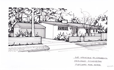
Artwork, other - Ink Line Drawing, Margaret Picken, 254 Springfield Rd., Nunawading, 2001
A property illustration by Margaret Picken Commissioned by a real estate agency for the purpose of advertising 254 Springfield Rd., Nunawading This property is listed as having sold for $220,000 in 2001 Made by using Rotring ‘Rapidigraph’ drafting pens with Rotring ink on Rapidigraph polyester drafting film, double matte. Trained as a cartographic draftsman within the mining industry, Margaret Picken is an artist who worked producing property illustrations for real estate agencies in eastern suburbs of Victoria from 1983-2005. Retiring from the industry as technological changes favored coloured photography over illustrations, and commissioning companies over sole contractors.This artwork is of Historical Significance as a record of local domestic architecture.A black ink line drawing on drafters film by Margaret Picken, of a black and white line drawing of a single story brick house with a sloping roof. On the left is a driveway leading to an connected garage. In the foreground isa horizontal timber fence, which is enclosing a front garden on right.245 Springfield Rd., Nunawading Margaret Picken © 2001 Fletchers Real Estatewhitehorse historical society, schwerkolt cottage, housing, architecture, margaret picken, house, garden, real estate, nunawading -
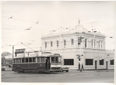 Ballarat Tramway Museum
Photograph - Black & White Photograph/s - set of 5, Charles Craig, 1971
Yields information about the intersection of Sturt St and Drummond St and its use by trams in the period before the closure of the SEC system. Shows the Southern Cross Hotel.Set of five Black and White photographs of trams near the intersection of Sturt St and Drummond St South, Hospital Corner. All have the Southern Cross Hotel in the background .1 - No. 31 crosses Drummond St, Gardens via Sturt St West, with two Johnnie Walker Roof adverts. .2 - No. 40 turns from Drummond St South en route to Lydiard St North, while another bogie car waits. Both trams have an electric cooking roof advert. .3 - No. 17 crosses Sturt St with two bogie trams in the view - appears to have been taken before .2. Note the passengers getting off the tram on the south side. .4 - No. 21 turning into Drummond St south, with destination of Sebastopol. Tram has an electric cooking roof advert. .5 - No. 33 crosses Sturt St from Sebastopol while another tram waits at the Sturt St stop. Photo by Charles Craig - during 1971. trams, tramways, sturt st, hospital corner, drummond st sth, tram 31, tram 40, tram 17, tram 21, tram 33 -
 Ballarat Tramway Museum
Slide - 35mm slide/s, Noel Simons, 21/11/1962 12:00:00 AM
Set of 6 transparencies taken on 21/11/1962 on Kodak mounts. 1189.1 - Bendigo No.11 at Quarry Hill terminus. Photo taken looking in along the route. Tram has destination of North Bendigo. 1189.2 - No. 21 in Pall Mall bound for North Bendigo. Tram has roof ads for Mamouney's furniture and SEC. In the background are the National Bank building, Dad and Dave's Cafe and the Beehive Buildings and the London Pharmacy. 1189.3 - No. 2 in Mitchell St, just after crossing over railway bridge. Photo taken after tram has passed photographer. Has what appears to be an SEC road works crew in the background. Has destination of Quarry Hill. 1189.4 - No. 17 climbing Mitchell St. on the start of the single track section, just before crossing the railway bridge. Has destination of Quarry Hill and the large Maples building sign in the background. 1189.5 - as for 1189.4 but after tram has passed photographer. Has an Ilford film roof ad and an SEC roof ad. Railway bridge in the background. 1189.6 - No. 21 at Charing Cross with passengers boarding. Tram has destination of North Bendigo and roof ads for SEC 'Electric Cooking' and Sandhurst Milk. In background are the buildings on the south side of High St. Also has a SEC worker in white overalls sweeping the track.Information written on in black ink and date stamped on purple ink. 1189.1 - "Birney car No. 11 in High St. Bendigo at Golden Square terminus" 1189.2 - "No. 21 in Pall Mall Bendigo near Charing Cross" 1189.3 - "No. 2 in Mitchell St. Bendigo, just after crossing bridge over railway line (Quarry Hill route)" 1189.4 - "No. 17 in Mitchell St. Bendigo, climbing the hill the bridge over the railway line. (Quarry Hill route)" 1189.5 - "No. 17 in Mitchell St., Bendigo approaching bridge over Railway line (Quarry Hill route)" 1189.6 - "No. 21 at Charing Cross, Bendigo"tramways, trams, bendigo, golden square, pall mall, mitchell st., quarry hill, tram 2, tram 11, tram 17, tram 21 -
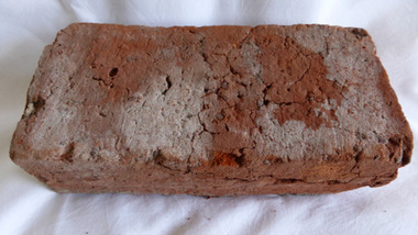 Warrnambool and District Historical Society Inc.
Functional object - Brick, 94 Merri Street Warrnambool, Circa 1850
The building at 94 Merri St is amongst the earliest buildings in Warrnambool. It was possibly constructed before 1854 and maybe as early as 1848. The original building consisted of four main rooms under a hip roof. The outer walls were masonry , apparently rubble The Heritage Council indcate that on the balance of probabilities this was the general store of Richard Osbourne and John Moffat Chisholm built in 1847-48.The building at 94 Merri Street had historical and architectural significance to the state of Victoria. It was a rare example of surviving, pre separation building with associated interest in its materials and components It is associated with Richard Osbourne who founded the Warrnambool Examiner(1851_1889) and the town’s first historian. Architecturally, the significance of the house lay in the hand -wrought timber framing. All the major timbers in this building had been hand sawn. The Gold rush of the 1850’s saw this process mechanised. A kitchen fireplace in the rear skillion included a large block of Merri Creek Mudstone, a combination of “tufa” and clay that was used in the Warrnambool District as an excellent substitute for fire bricks. The house was demolished in 2011 and items of significance were salvaged, this brick being one. While some bricks were imported, there is evidence that there were a number of brick burning businesses in operation around this time. However it is difficult to ascertain to which group this brick belongs. Red clay rectangular brick. Contains some small gravel like material, possibly ferrous buckshot, grey mortar remnants on side and diagonal crack along one side.warrnambool, 94 merri street, richard osbourne, john moffat chisholm, hand sawn timber, brick, building materials -
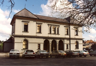 Federation University Historical Collection
Photograph - Black and white sketch, Former Ballarat Supreme Courthouse (later Courthouse Theatre), c1994
The former Ballarat Supreme Court building was unique in design for the time. The central court room and the flanking wings were all two storey with hipped roofs. This made this building different from other Public Works designs. The building was erected by the Public Works Department in 1868. Early in the 1940s the former Supreme Court was abandoned. Today the building is used as a performing arts centre.Colour photograph of the former Ballarat Supreme Court. This building did not follow the regular design for Public Works design. Central court room and adjacent wings are all two storey. The central section is recessed with ground floor arcade and arched windows. ballarat school of mines, former ballarat supreme courthouse, courthouse theatre, hipped roof, public works department, performing arts centre, legal -
 Whitehorse Historical Society Inc.
Photograph, Roger de Stoop
Roger de Stoop had the land cleared in 1952 and building started in 1953. He and his family moved in in 1954. The house has now been demolished but it was about 35 squares, was made of timber with blue slate roof, the slates having come from Belgium. Roger de Stoop had his outside timber walls painted in a dark colour.Black and white photocopy of house built by Roger de Stoop on land in Blackburn North (Henry Street - later 35 Middlefield Road). The house was called Middlefield House by local people.de stoop. roger. middlefield house -
 Ballarat Tramway Museum
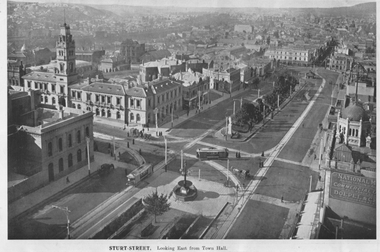
Photograph - Illustration, "Sturt Street looking east from Town Hall", c1907
The illustration looks northeast from Town Hall overlooking the intersection of Sturt and Lydiard Streets, towards Black Hill and Grenville St. Has two ESCo trams in view, both with roof-mounted destinations, Post Office, and the Grenville St shelter. C1907. Has the National Mutual building in the bottom right-hand corner advertising Commercial Unity and Doepel & Co.Yields information about the intersection of Sturt and Lydiard Streets and associated buildings.Illustration cut from a magazine or publicationballarat, illustrations, post office, sturt st, lydiard st, esco -
 The Beechworth Burke Museum Research Collection
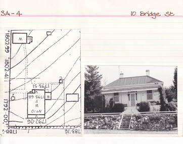
Card (Series) - Index Card, George Tibbits, 10 Bridge Street, Beechworth, 1976
George Tibbits, University of Melbourne. Faculty of Architecture, Building and Town & Regional PlanningIndex system that support the research for Beechworth : historical reconstruction / [by] George Tibbits ... [et al]Arranged by street names of BeechworthEach index card includes: street name and number of property, image of property, allotment and section number, property owners and dates of ownership, description of the property according to rate records, property floor plan with dimensions.beechworth, george tibbitsbeechworth, george tibbits -
 The Beechworth Burke Museum Research Collection
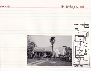
Card (Series) - Index Card, George Tibbits, 18 Bridge Street, Beechworth, 1976
George Tibbits, University of Melbourne. Faculty of Architecture, Building and Town & Regional PlanningIndex system that support the research for Beechworth : historical reconstruction / [by] George Tibbits ... [et al]Arranged by street names of BeechworthEach index card includes: street name and number of property, image of property, allotment and section number, property owners and dates of ownership, description of the property according to rate records, property floor plan with dimensions.beechworth, george tibbitsbeechworth, george tibbits -
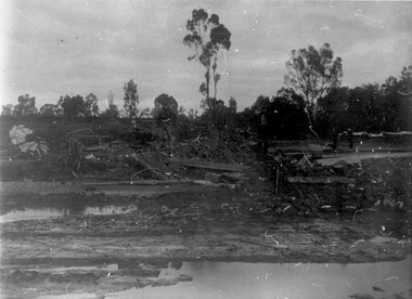 Tarnagulla History Archive
Photograph: Debris after flood, Newbridge, Debris after flood, Newbridge, 1909 (original image)
On 20th August, 1909 the Laanecoorie Weir broke away and released 18.3 million cubic metres of water through the opening and causing severe damage to all towns downstream. At Newbridge, Petersen's bakery collapsed and Simpson's Store and Hotel flooded to the roof. The billiard table was later found in a tree five miles down the Loddon near Learmonth. Murray Comrie Collection. Monochrome photograph, image depicting debris in the area near Loddon River at Newbridge after major flood in 1909. This is a very dark copy of an older original. Copy probably made by Murray Comrie in the 1960s.newbridge, loddon river, flood -
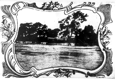 Tarnagulla History Archive
Photographs: Loddon River, Newbridge after flood, Loddon River, Newbridge after flood, 1909 (original image)
On 20th August,1909 the Laanecoorie Weir broke away and released 18.3 million cubic metres of water through the opening and causing severe damage to all towns downstream. At Newbridge, Petersen's bakery collapsed and Simpson's Store and Hotel flooded to the roof. The billiard table was later found in a tree five miles down the Loddon near Learmonth. Murray Comrie Collection. Two copies of a monochrome photograph, image part of damaged bridge in the area near Loddon River at Newbridge after major flood in 1909. This is a very grainy and dark copy of an older original. Copy probably made by Murray Comrie in the 1960s.newbridge, loddon river, flood, bridge -
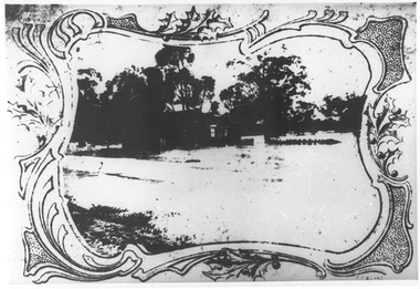 Tarnagulla History Archive
Photographs: Loddon River, Newbridge after flood, Loddon River, Newbridge after flood, 1909 (original image)
On 20th August,1909 the Laanecoorie Weir broke away and released 18.3 million cubic metres of water through the opening and causing severe damage to all towns downstream. At Newbridge, Petersen's bakery collapsed and Simpson's Store and Hotel flooded to the roof. The billiard table was later found in a tree five miles down the Loddon near Learmonth. Murray Comrie Collection. Two copies of a monochrome photograph, image depicts the area near Loddon River at Newbridge after major flood in 1909. This is a very grainy and dark copy of an older original. Copy probably made by Murray Comrie in the 1960s.newbridge, loddon river, flood, bridge -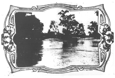
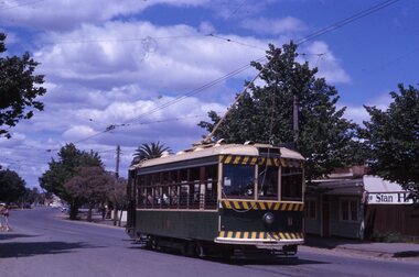
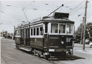 Melbourne Tram Museum
Photograph - Black and White - VR Tram 37 - Elwood Depot, Victorian Railways (VR)
Photograph of tram 37 shows the Victorian Railways colour scheme, the oil lamp that was provided on VR trams on the St Kilda to Brighton, Electric Street Railway. Has 3 Robur Tea roof advertisements. The tram is shunting at the depot or waiting to run to St Kilda Railway Station, possibly after the closure of section south of the depot. Original Victorian Railways Photograph. Yields information about the location, the streetscape and the trams in use at the time. Black and white photograph of Victorian Railways tram 37 outside Elwood Depot in St Kilda St, possibly in the early 1950s. Original Victorian Railways Photograph.tramways, trams, vr trams, elwood tram depot, st kilda st, tram 37, victorian railways -
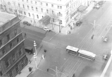 Melbourne Tram Museum
Photograph, Menzies Hotel and the Goldsborough & Mort Woolstore with a cable tram crossing William Street in Bourke Street, c1937
The photograph shows a cable tram in Bourke St, crossing over the electric tram track in William Street. The Menzies Hotel 1867 (see reference) is in the background, along with the Goldborough Mort Woolstore building 1862 on the opposite corner. Also in the photo are the Melbourne Centenary "Lollypop" street decorations of 1934. The photo appears to be taken from the roof of the Shell Building in William Street. Yields information about the Menzies Hotel and the intersection of Bourke and William St. Photograph, black and white, plain papertrams, tramways, cable tram, bourke st, william st, menzies hotel, goldsborough mort, melbourne centenary -
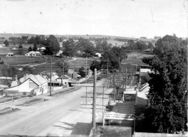 Linton and District Historical Society Inc
Photograph, Taylors Super Snaps Ballarat, Sussex Street, Linton
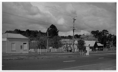
Photograph taken from high vantage point further along Sussex Street. Visible east side: Edinburgh Bakery, Preston's shop, Wishart's blacksmiths. Church of England vicarage in the distance. Visible west side: roofs of Morgan's and Sandow's stores. The photograph is undated but thought to have been taken in the 1940s, as there are electricity poles in the street. (Electricity came to Linton in 1939).Very small photograph of Sussex Stret, Linton, view to south-east.sussex street linton -
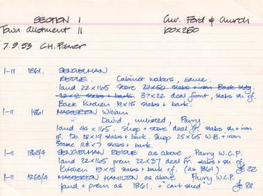 The Beechworth Burke Museum Research Collection
Card (Series) - Index Card, George Tibbits, Corner of Ford and Church Streets, Beechworth, 1976
George Tibbits, University of Melbourne. Faculty of Architecture, Building and Town & Regional PlanningIndex system that support the research for Beechworth : historical reconstruction / [by] George Tibbits ... [et al]Arranged by street names of BeechworthEach index card includes: street name and number of property, image of property, allotment and section number, property owners and dates of ownership, description of the property according to rate records, property floor plan with dimensions.beechworth, george tibbitsbeechworth, george tibbits -
 Glenelg Shire Council Cultural Collection
Photograph - Photograph - Oak Tree, 1970-1980
Possibly from Bowerbird Museuma) Section of oak tree planted by Francis Henty in 1843. Tree died in 1953, had a branch span of 97ft. The piece of oak is attached by hooks and chains to a framework with a galvenised roof. Plaque with info re tree's hisotry attched to oak. b) Same as a - slightly differenct viewfrancis henty -
Glenelg Shire Council Cultural Collection
Photograph - Photograph - Bridgewater Hotel, Victoria, n.d
Black and white photo of the Bridgewater Hotel, front view. Double storey building, front verandah, tin roof, chimney each side of building. Three windows on first floor, window either side of door, ground floors, picket fence with gate; sand dunes behind.Back: 'BRIDGEWATER HOTEL' -printed in capitals, blue biro