Showing 3070 items matching "scales"
-
 Flagstaff Hill Maritime Museum and Village
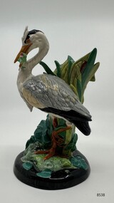
Decorative object - Minton Majolica model of a Grey Heron, 2001
Royal Doulton as part of the Minton Miniature series produced this heron model in 2001. A limited edition of 1,793 pieces were made, and this heron is number 89. The heron is a scaled down model of the original life-size piece first produced by Paul Comolera, c. 1892, as a walking stick and umbrella stand. Comolera was a French artist and sculptor, renowned for dramatic naturalistic forms, and life-size renditions of birds and animals that won him admiration in public and artistic circles. The Warrnambool Art Gallery (WAG) has a life-sized Heron in its collection. A rare miniature heron demonstrates the artistry and skill required to produce Majolica ware during the 19th century and the present.A miniature grey heron standing by bulrushes and holding a struggling fish in its beak, its plumage naturalistically coloured, on a circular base glazed in tones of grey and green and applied with further leaves and water lilies.Inscribed at the base Minton founded 1793, made in Englandminton & co., majolica, miniature model, flagstaff hill maritime museum, stoke upon trent, paul comolera, staffordshire -
 Ithacan Historical Society
Photograph, Earthquakes: Rebuilding the Church of Taxiarchion, Ithaca, 1953
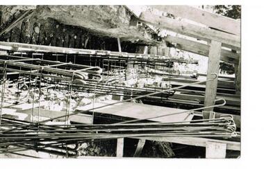
The 1953 catastrophic earthquakes on Ithaca and nearby Cephalonia caused extensive damage destroying many houses and buildings. The tremors reached 7.2 on the Richter Scale and the devastation was exacerbated by the quake occurring at midday when many people were cooking so fires spread rapidly across the island. The Holy Church of Taxiarchion, located in northern Ithaca on the hill overlooking the village of Platrithia and Afales Bay, was extensively damaged. A committee was formed to rebuild the church and its reconstruction following the earthquake is testament to the determination and resilience of the island's people to overcome hardship and disasters. A black and white photograph of scaffolding supporting a building destroyed in earthquake. A trench along the side of the structure is being prepared for further reinforcement with steel rods before the concrete is poured.The photo a has stamp on the back from the local committee overseeing the rebuilding of the church. It is written in Greek and states the following: REBUILDING COMMITTEE/ HOLY CHURCH OF TAXIARCHES/PLATRITHIA ITHACA. -
 Parks Victoria - Wilsons Promontory Lightstation
Muslin & Wick
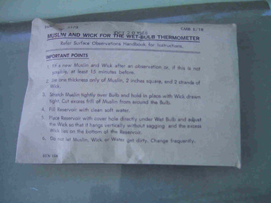
This item, which dates to 1988, is contained in the original supply packet and survives in good condition. It was commonly used by lightkeepers for both wet and dry bulb thermometers, with the muslin going into the bottom of the dry bulb where it was held in place by the wick and ‘end of the wick was then placed in a jar of deep water to keep the bulb cool’. The difference in temperatures between the dry and wet bulb thermometers could then be worked out to establish the dew point in the air.They were common in lightstations, but this intact item remains in the original packaging and is a fine representative example of its kind. It was acquired from the Bureau of Meteorology. Recording and communicating weather readings was an important facet of lightstation work and a number of different but related items of meteorological equipment survive at the six lightstations managed by parks Victoria. The Cape Nelson collection includes a pair of Australian-made thermometers in their original box, both in Fahrenheit, with one recording the minimum, the other the maximum temperature and a barometer table with instructions for correcting readings. Cape Otway has a Beaufort Scale, a table of wind forces which lists 12 types on a scale of 1 to 12, and provides associated speed in knots and travel time per minute or hour. Gabo Island has an anemometer, wind speed indicator and a wind speed recorder.Muslin and wick for a wet bulb thermomenter in unopened white paper packaging with directions for use printed on the package on the front.On front of package,"MUSLIN AND WICK FOR WET BULB THERMOMETER......." -
 Flagstaff Hill Maritime Museum and Village
Furniture - Carved Panel, Campbell, Sloss and McCain, ca. 1886
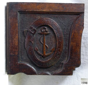
There were at least three 1880s vessels named Lady Loch, all built in Victoria; a river launch (ca 1884-ca 1916, originally named Lady of the Lake), a steamer ferry (1884-1920s) and a government lighthouse tender steamer HMV Lady Loch (1886-1962.) The carved wooden panel was removed from the HMV SS Lady Loch before the vessel was scuttled in 1962. About HMV SS Lady Loch: - The HMV SS Lady Loch was an iron steamship built in Footscray, Melbourne, by Campbell, Sloss and McCain in 1886 for the colonial Victorian government’s Department of Trade and Customs. It was armed with a 6-inch gun and two 1-inch Nordenfelt guns. The Sydney Morning Herald of 27th January 1888 describes the vessel in detail. It even comments on the interior of the Saloon “The wood work … is on a very elaborate scale and is exceedingly neat …”. The HMV Lady Loch performed Customs duties and serviced the lighthouses along the coast. The scale could have measured goods for the Customs Tax, or for measuring out supplies for the lighthouse keepers. The vessel was named after Lady Elizabeth Loch, wife of Sir Henry Loch, Governor of Victoria from 1884 to 1889. In 1932 Lady Loch was converted to a hulk and used in Brisbane, and finally scuttled in 1962 at Moreton Bay, Queensland. The carved wood panel has importance due to its connection to the 1886 HMV Lady Loch, a vessel of great significance to Melbourne’s shipbuilding industry. It was the largest auxiliary vessel in the Victorian Colonial Government’s fleet and the first prominent vessel launched by Melbourne’s shipbuilding industry. It is significant to the history of the Victorian era and the colonial navy's steamship HMV SS Lady Loch. The vessel carried out Custom's work, and the scales were available to weigh goods that could attract taxes and goods for distribution to lighthouse keepers. The HMV Lady Loch was also important part of Victoria's maritime history, its communication with and support of the lighthouse keepers along the coast of Victoria.Heavy carved wooden panel, square, representing a framed plaque. The bottom and right edges are scalloped on the outer and inner edges. A carved oval within the frame represents a wide belt with buckle and tongue, and indents for the belt holes on its left and a carved inscription runs from top centre to bottom centre on the right side of the belt. Within the belt is the maritime symbol of an upright anchor in front of a rope. It was once part of the furnishing of the steamer HMVS Lady Loch and was removed before the ship was scuttled.Carved within the belt: "STEAM SHIP LADY LOCH"warrnambool, shipwreck coast, flagstaff hill, flagstaff hill maritime museum, flagstaff hill maritime village, scale, salter, spring balance, silvester's patent, lady loch, steamship, hmv, colonial navy, victoria, lady elizabeth loch, custom's vessel, lighthouse tender, 1886, government vessel, victorian government, wood panel, timber panel, carved panel, carved log, lady loch logo, belt enclosing and anchor, anchor within belt, lady loch steam ship, wooden panel, ship's furinshing, ship's panel, ship's logo, great ocean road, government steamer, victorian colonial government, colonial vessel, public works, bass straight, hmv lady loch, hmvs lady loch, hmv ss lady loch, melbourne, melbourne shipbuilder, ship furnishings, wooden furnishings, decorative panel, carved emblem, carved logo, carved symbol, campbell stoss and mccain, government tender, victorian customs -
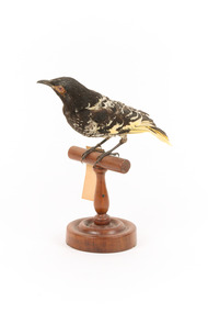 The Beechworth Burke Museum
Animal specimen - Regent Honey-Eater, Trustees of the Australian Museum, 1860-1880
The Warty-faced honeyeater Formerly more widely distributed in south-eastern mainland Australia from Rockhampton, Queensland to Adelaide, South Australia, the Regent Honeyeater is now confined to Victoria and New South Wales, and is strongly associated with the western slopes of the Great Dividing Range. The Regent Honeyeater is found in eucalypt forests and woodlands, particularly in blossoming trees and mistletoe. It is also seen in orchards and urban gardens. This species is critically endangered. They are native to Southeastern Australia. Specimen is mounted accurately. Colour around the eyes is red whereas they are yellow normally. This specimen is part of a collection of almost 200 animal specimens that were originally acquired as skins from various institutions across Australia, including the Australian Museum in Sydney and the National Museum of Victoria (known as Museums Victoria since 1983), as well as individuals such as amateur anthropologist Reynell Eveleigh Johns between 1860-1880. These skins were then mounted by members of the Burke Museum Committee and put-on display in the formal space of the Museum’s original exhibition hall where they continue to be on display. This display of taxidermy mounts initially served to instruct visitors to the Burke Museum of the natural world around them, today it serves as an insight into the collecting habits of the 19th century. This specimen is part of a significant and rare taxidermy mount collection in the Burke Museum. This collection is scientifically and culturally important for reminding us of how science continues to shape our understanding of the modern world. They demonstrate a capacity to hold evidence of how Australia’s fauna history existed in the past and are potentially important for future environmental research. This collection continues to be on display in the Museum and has become a key part to interpreting the collecting habits of the 19th century.The striking Regent Honeyeater (Warty-faced honeyeater) has a black head, neck and upper breast, a lemon yellow back and breast scaled black, with the underparts grading into a white rump, black wings with conspicuous yellow patches, and a black tail edged yellow. In males, the dark eye is surrounded by yellowish warty bare skin. Females are smaller, with a bare yellowish patch under the eye only, and have less black on the throat. Young birds resemble females, but are browner and have a paler bill. The colouring of this particular specimen helps identify it as male.Swing-tag: 56a. / Warty-Faced Honeyeater / See Catalogue, page 18taxidermy mount, taxidermy, animalia, burke museum, beechworth, australian museum, skin, reynell eveleigh johns, bird, australian bird, honey-eater, warty-faced honey-eater, regent honeyeater, critically endangered, yellow -
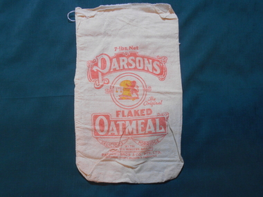 Bendigo Historical Society Inc.
Textile - FLOUR BAG COLLECTION: PARSONS BROS OATMEAL, 1900-1950
Textiles. Calico bag printed on both sides with red, white and yellow, ''PARSONS The Original FLAKED Oatmeal 7 LBS NET.Delious Porridge with only ten minutes boiling''. Parsons Bros & Co, Pty., Ltd., Melbourne, Sydney, Brisbane and Fremantle. Centre picture within a red circle of an upright Lion holding a yellow wheat sheaf beside a set of scales. Brothers Leonard and George Parsons left England for Australia following the discovery of gold. In 1861 the Uncle Tobys Company was born, originally under the name of Parsons Bros.textiles, domestic, parson bros calico flour bag -
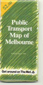 Ballarat Tramway Museum
Map, Ministry of Transport and The Met, "Public Transport Map of Melbourne" - "Effective August 1988", 1988
Map - Pocket size - folded - public transport map of Melbourne, printed in colour on art paper, showing public transport services in greater Melbourne, an index of localities. The City Saver area shown in detail. On the rear, route numbers, line maps of tram routes, train lines, outer metropolitan services, ticketing information, Transport Neighbourhoods, . Shows the St Kilda and Port Melbourne light rail lines. Price $2. Shows "The Met" logo. On front under The Met logo and above the scale bar is "Effective 1/7/1988". Niltrams, tramways, melbourne, map, routes -
 Bendigo Historical Society Inc.
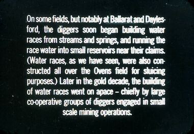
Slide - DIGGERS & MINING. GETTING THE GOLD, c1850s
Diggers & Mining. Getting the Gold. Slide: On some fields, but notably at Ballarat and Daylesford, the diggers soon began building water races from streams and springs, and running the race water into small reservoirs near their claims. (Water races, as we have seen, were also constructed all over the Ovens field for sluicing purposes.) Later in the gold decade, the building of water races went on space - chiefly by large co-operative groups of diggers engaged in small scale mining operations. Markings: 69 994.LIF:4. Used as a teaching aid.hanimounteducation, tertiary, goldfields -
 Kew Historical Society Inc
Map, MMBW, MMBW Plan No.40 Collingwood & Kew, 1900-1910
The Melbourne and Metropolitan Board of Works (MMBW) was established by an act of the Victorian Parliament in 1890 to prepare for and to implement a sewerage and water reticulation system across what was then inner Melbourne, its surrounding and middle distance suburbs, including Kew. The MMBW was disbanded in 1991.The map collection of the Kew Historical Society has at its core the historic maps assembled and originally stored in the City Engineer's Department of the City of Kew. These include maps in a number of scales. The vast majority of maps were produced by the MMBW in the first two decades of the twentieth century, and are solid working maps, backed by linen for durability. These maps are historically significant to Kew, the City of Boroondara and to the history of the development of state utilities in Victoria. A number of the Kew maps have additional details added by former municipal officers, including the levels reached by various floods. As these were working documents, information was added to them long after the period of their initial production and distribution.Early map of part of the Borough of Kew, created in the first decade of the twentieth century, at a scale 160 ft to 1 inch. The map covers what was then the south western section of Kew, bordered on its north by Studley Park Road, in the west by Walmer Street and the River Yarra, by High Street South and Princess Street in the East and Barkers Road in the south. The map shows the extent of urban development by that time, prominent institutions and the outlines of built structures in the municipality. Contour lines and historic flood levels were added in ink to the map at a later stage.MELBOURNE AND METROPOLITAN BOARD OF WORKS / PLAN NO. 40 / COLLINGWOOD & KEWmelbourne & metropolitan board of works, mmbw maps, mmbw plans, borough of kew, cartography -
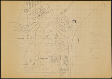 University of Melbourne, Burnley Campus Archives
Plan, Victorian College of Agriculture and Horticulture - Burnley Site Plan, 1986
Given to Archives by Jim Galea (Staff 1985-87).Prints and paper copies of plan of Burnley Campus by Fresco Color Group No 60 337-A dated February 1986. Scale 1:500. (1) 3 prints of the plan, 1 small, 2 larger (1 with legend and grid). (2) Tracing paper copy, no legend, no grid. (3) Paper copy, legend and grid, of Ornamental Garden Area. (4) "Drawing Orchard Site Plan," grid and legend printed, the rest hand drawn. (5) Film and paper copies without grid and legend. N.B. 11.0716, Further development of Plan. vcah, burnley, fresco color group, orchard, burnley gardens -
![Map, Liquidator's sale, 1896. [Woolpack Estate, Bacchus Marsh]](/media/collectors/5e461d8021ea67224c82f2a1/items/6779ee97032b72846b5995f2/item-media/6779ef33032b72846b599b30/item-fit-380x285.jpg) Bacchus Marsh & District Historical Society
Bacchus Marsh & District Historical SocietyMap, Liquidator's sale, 1896. [Woolpack Estate, Bacchus Marsh]
The Woolpack Estate was an area of land owned by various landowners in the Bacchus Marsh area since the early Colonial period of the 1840s. The area was located on the eastern side of the Bacchus Marsh township about 7 kilometers from the town. The Lerderderg River ran through part of the land and so did the Melbourne to Ballarat Road. The historic Woolpack Inn associated with James Crook was also located on this land. By 1896 150 acres of this land was under the control of liquidators for the Federal Bank of Australasia who instructed that the land be sub-divided and sold in lots by public auction. A successful sale was held on 24 June 1896. Most of the blocks of land were sold for higher than expected prices and most of the buyers were people from the town and district of Bacchus Marsh. The map includes various details about the land which is described on the map as an "important sale of rich alluvial irrigable flat land in the Bacchus Marsh Valley, and other properties". The auction was conducted by the local agents W. Anderson and Bence in conjunction with Pearce Brothers also of Bacchus Marsh.A single page paper map showing a plan of 150 acres of land from the Woolpack Estate to be sold in various lots in June 1896. Also shown on the map are lots for sale at Robinson's Farm on Coimadai Creek and allotments near Bacchus Marsh railway station, including lots on Government Road (East Maddingley Road), View Street and Government Road (Parwan Road). No scale provided. The map is pasted into a bound volume containing 76 maps or plans in total. High resolution digital image stored on BMDHS computer network. land sales bacchus marsh, bacchus marsh victoria maps, woolpack estate bacchus marsh victoria -
 University of Melbourne, Burnley Campus Archives
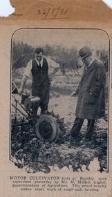
Newspaper - Newspaper Cutting, The Sun-News Pictorial, "And the glory of the garden shall never pass away" - Kipling, 1930-1940
(2) Newspaper page of a colour-touched-up photo of a student, pasted to one side of a sheet of paper, with the caption: "A student of the Burnley Horticultural School at Melbourne's Garden Week." (1) Pasted on the other side of the paper is a newspaper cutting from The Sun, 26 May, 1930. It is a photo of two men with a motor cultivator, with the caption: "Motor cultivator tests at Burnley were supervised yesterday by Mr H. Mullett (right), Superintendent of Agriculture. The other man appears to be the Principal, A. W. Jessep.This petrol novelty makes short work of small-scale farming."garden week 1930, dahlias, machinery, motor cultivator, h mullett, superintendent of agriculture, orchard -
 University of Melbourne, Burnley Campus Archives
Plan, S. Subari, Footscray Park Existing Conditions, 1987-1991
Plans by the City Engineer, City of Footscray File No 4329 drawn by S. Subari 25/9/1987. Scale 1:1000. (1) Sheet 1 of 2, 1 full plan with plant legend for trees by letter, 2 sections of plan enlarged with numbering for "Other Trees," different numbering on each. (2) Sheet 2 of 2, full plan with plant legend for trees by letter. (3) Footscray Park: Key to Tree Species. (4) 2 copies handwritten notes by John Hawker, 1 set numbered. Plant survey January 1991.footscray park, s. subari, city of footscray, trees, public parks -
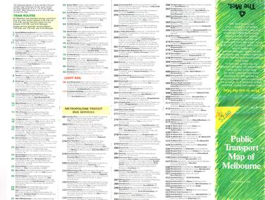 Melbourne Tram Museum
Map, The Met, "Public Transport Map of Melbourne" - "Effective August 1988", 1988
Map - Pocket size - folded - public transport map of Melbourne, printed in colour on art paper, showing public transport services in greater Melbourne, an index of localities. The City Saver area shown in detail. On the rear, route numbers, line maps of tram routes, train lines, outer metropolitan services, ticketing information, Transport Neighbourhoods, . Shows the St Kilda and Port Melbourne light rail lines. Price $2. Shows "The Met" logo. On front under The Met logo and above the scale bar is "Effective 1/7/1988".In ink in top left hand corner, "11" in a circle.trams, tramways, melbourne, map, routes -
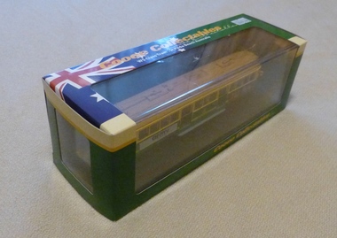 Melbourne Tram Museum
Leisure object - Model tram and presentation case, Cooee Concepts Pty Ltd, Model of Melbourne City Circle tram No. 812, 2001
Model of Melbourne City Circle tram No. 812 in a presentation cardboard box, made by Cooee Concepts Pty Ltd in China. Tram secured into the card box by two screws just behind the life guard. Made from plastic with trolley poles from metal (trolley poles can be moved) light brown roof, green and yellow sides, black No. 15 trucks, advertising the Army and Haig Scotch Whiskey. The box sides provides details of the tram, scale and a photo of a tram with Luna Park in the background and interior view of a tram.trams, tramways, models, city circle, cooee models, sw5 class, tram 812 -
 University of Melbourne, Burnley Campus Archives
Plan, Concept Plan Pruning Garden Field Station VCAH Burnley, 1985-1995
2 sest of Concept Plans for the design of a Pruning Garden in the Field Station. (1) Pencil drawing on tracing paper, "Pruning Garden Field Station." (2) On tracing paper, "Concept Plan Pruning Garden Field Station VCAH Burnley 25.03.1995 by "JK". (3) 3 copies of (2) on paper. (4) 4 reduced size copies with some annotation. (5) Typed list, "Plants for Pruning Garden." (6) Tracing paper copy, Pruning Garden VCAH Burnley, Aug 1985. Scale 1: (7) Hard copy of (6).pruning, field station, vcah, burnley, gardens, jill kellow, experimental work on fruit trees -
 Bendigo Military Museum
Map - Australian Topographical Survey NAGAMBIE SW Sheet, 1 inch:1 Mile, NW portion Plane Table Field sheet 1921, Australian Survey Corps, 1921
This is a coloured reproduction print of an original Plane Table compilation map sheet of Nagambie area 1inch to 1 Mile scale compiled by Sgt Jack Cullen Australian Survey Corps 30 September 1921. Jack was one of the foundation members of the Australian Survey Corps. Of particular interest is the fact that this is a heighted compilation with contouring (required for Military use) as many early maps were purely planimetric. A table on the right hand side details the number of days that it took to produce the compilation. The reverse side of this print is a copy of the Tallarook plane table South East field sheet.Reprinted coloured Image of Australian Topographical Survey NAGAMBIE SW Sheet,1 inch:1 Mile, NW portion hand drawn Plane Table Field sheet. Includes an itemized summary of work, signed by Sgt J Cullen Australian Survey Corps September1921.royal australian survey corps, rasvy, fortuna, army survey regiment, army svy regt, asr -
 Eltham District Historical Society Inc
Photograph - Aerial Photograph, Landata, Research, Vic, Apr. 1963
Centred on present day Marconi Court, Research bounded by Maroondah Aqueduct to north, Thompson Crescent to south, Joselyn Drive to east and Eltham Research Oval to west. Historic Aerial Imagery Source: Landata.vic.gov.au Aerial Photo Details: Project No :486 Project : MELBOURNE (1963) PROJECT Run : 5 Frame : 62 Date : 04/1963 Film Type : B/W Camera : RC8 Flying Height : 5100 Scale : 9600 Film Number : 1805 GDA2020 : 37°42'24"S, 145°10'43"E MGA2020 : 339434, 5825157 (55) Melways : 22 F3 (ed. 42)aerial photo, neil webster collection, 1963-04, joselyn drive, marconi court, melway 22f3, research (vic.), research oval, thompson crescent -
 Eltham District Historical Society Inc
Photograph - Aerial Photograph, Landata, Research, Vic, Apr. 1972
Centred on present day Maroong Drive, Research bounded by Allendale Road to north, Thompson Crescent to south, Eltham College to east and Parsons Road to west. Historic Aerial Imagery Source: Landata.vic.gov.au Aerial Photo Details: Project No :985 Project : MELBOURNE 1972 Run : 26 Frame : 193 Date : 04/1972 Film Type : B/W Camera : RC10 Flying Height : 5700 Scale : 9600 Film Number : 2636 GDA2020 : 37°42'04"S, 145°10'33"E MGA2020 : 339187, 5825794 (55) Melways : 22 F1 (ed. 42)aerial photo, neil webster collection, 1972-04, allendale road, eltham, eltham barrel, eltham college, maroong drive, melway 22f1, parsons road, research (vic.), thompson crescent -
 Eltham District Historical Society Inc
Photograph - Aerial Photograph, Landata, Eltham, Vic, Apr. 1972
Centred on present day Ryans Road at Sandra Avenue, Eltham bounded by Progress Road to north, Brougham Street to south, Bible Street to east and Outlook Crescent to west. Historic Aerial Imagery Source: Landata.vic.gov.au Aerial Photo Details: Project No :985 Project : MELBOURNE 1972 Run : 27 Frame : 48 Date : 04/1972 Film Type : B/W Camera : RC10 Flying Height : 5700 Scale : 9600 Film Number : 2636 GDA2020 : 37°42'41"S, 145°08'38"E MGA2020 : 336392, 5824574 (55) Melways : 21 H4 (ed. 42)aerial photo, neil webster collection, 1972-04, eltham, bible street, brougham steet, melway 21h4, outlook crescent, progress road, ryans road, sandra avenue, montmorency -
 Eltham District Historical Society Inc
Photograph - Aerial Photograph, Landata, Montmorency, Vic, Apr. 1972
Centred on present day Olympic Avenue at Grand Boulevard, Montmorency bounded by Meruka Drive to north, Main Road to south, Main Road to east and Alban Street to west. Historic Aerial Imagery Source: Landata.vic.gov.au Aerial Photo Details: Project No :985 Project : MELBOURNE 1972 Run : 28 Frame : 206 Date : 04/1972 Film Type : B/W Camera : RC10 Flying Height : 5700 Scale : 9600 Film Number : 2635 GDA2020 : 37°43'21"S, 145°07'46"E MGA2020 : 335154, 5823329 (55) Melways : 21 E7 (ed. 42)aerial photo, neil webster collection, 1972-04, eltham, alban street, grand boulevard, lower plenty, main road, melway 21e7, meruka drive, montmorency, olympic avenue -
 Eltham District Historical Society Inc
Photograph - Aerial Photograph, Landata, Eltham, Vic, Apr. 1972
Centred on present day Mays Road at Stringybark Road, Eltham bounded by Nyora Road to north, Yarra River to south, Reynolds Road to east and Bible Street to west. Historic Aerial Imagery Source: Landata.vic.gov.au Aerial Photo Details: Project No :985 Project : MELBOURNE 1972 Run : 28 Frame : 209 Date : 04/1972 Film Type : B/W Camera : RC10 Flying Height : 5700 Scale : 9600 Film Number : 2635 GDA2020 : 37°43'33"S, 145°09'28"E MGA2020 : 337647, 5823013 (55) Melways : 22 B8 (ed. 42)aerial photo, neil webster collection, 1972-04, eltham, bible street, mays road, melway 22b8, nyora road, reynolds road, stringybark road, yarra river -
 Eltham District Historical Society Inc
Photograph - Aerial Photograph, Landata, Eltham, Main Road; Henry St to Bellevue Rd, Dec. 1945
Eltham, Main Road; Henry St to Bellevue Rd, and east along Luck St to present day Eltham East School Historic Aerial Imagery Source: Landata.vic.gov.au Aerial Photo Details: Project No :5 Project : MELBOURNE AND METROPOLITAN AREA PROJECT Run : 36 Frame : 60549 Date : 12/1945 Film Type : B/W Camera : EAG4 Flying Height : 10200 Scale : 6000 Film Number : 228 GDA2020 : 37°42'45"S, 145°08'59"E MGA2020 : 336903, 5824465 (55) Melways : 21 K4 (ed. 42)aerial photo, arthur street, bellevue road, bible street, diamond street, dudley street, elsa court, eltham, eltham east primary school, gahan house, henry street, livingstone road, luck street, main road, pryor street, neil webster collection -
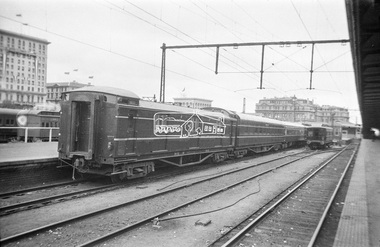 Eltham District Historical Society Inc
Photograph, George Coop, The Royal Train, on display at Spencer Street Railway Station during the 1954 Victorian Railways Centenary Exhibition, Sep. 1954
It appears that the Royal Train may have been split to suit display purposes and restraints. In this image is seen the CE Guard's Brake Van which would be located as the first coach behind the locomotive. "V.R. Cavalcade" Centenary 1854-1954 Exhibition (11-25 Sep 1954) presented a model railway occupying about 1,400 square feet in the Lower Town Hall featuring a number of model railway working scale models. The exhibition also included a display of rolling stock, track, electrical and other railway equipment held at Spencer Street Railway Station.Digital TIFF file Scan of Kopdak 620 black and white negative transparencygeorge coop collection, royal train, display, spencer street railway station, v.r. cavalcade, victorian railways centenary 1854-1954 exhibition, ce guard's brake van -
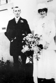 Surrey Hills Historical Society Collection
Photograph, Wedding Day of Amelia Amy Jacobs and James Dodgshun from Surrey Hills, 1916
Amelia Allan (Amy) Jacobs on her marriage to James Dodgshun in 1916; photographed at the home of her grandfather, "Terreglea" in Boundary (Warrigal) Road, Surrey Hills. Amelia attended Ormiston Girls' School in Mont Albert soon after its opening in 1900. Her mother was Eleanor Mills, youngest daughter of Robert Shortbridge Mills and Ann Lovelady. She died soon after the birth of Amy. Her father was Henry Atwood Jacobs. Following Eleanor's death Henry married Amy Lilian Scales. The donor Winifred Yarnold (nee Jacobs) was their youngest daughter and Amy's half-sister.Lady dressed as bride wearing a white dress and possibly a lace jacket with a fluffy collar and matching hat, carrying a large bouquet of flowers. The man is wearing a dark suit and carrying a top hat.wedding dresses, house names, surrey hills, warrigal road, clothing and dress, hats, terreglea, the tower house, weddings, wedding parties, ormiston girls school, schools, mont albert, miss amelia allan jacobs, miss amy jacobs, mr james dodgshun -
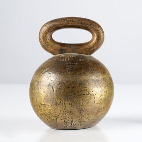 City of Greater Bendigo - Civic Collection
Instrument - Weights and Measures, Potter, Standard Volume 28 lbs, c 1863
Victoria became a separate colony of the United Kingdom on 1 July 1851; however it took until 1864 for a workable system of weights and measures administration to be introduced. Standard of weights and measures were obtained and issued to local authorities to administer in their local areas. These standards were numbered, as were the Crown stamps used by inspectors to indicate that trade weights and measures had been checked and found to be legal to use in the day-to-day businesses of local traders. By the 1870's each local council had a set of standards that were used to test the scales, weights and measures of local merchants and businesses.Standard 28lb brass measure. Ball shaped weight with single handle on top. Front; Standard / lb / 28 AV / Potter / London / 25.8.1864 / 24.3.90 / 9.6.95 / 17.10.00 / 5.10.05 / 20.3.11 / 25.8.16 / 27.9.21 / 10.11.26 / 17.11.31 / 16.11.35 / 4.12.41 / 24.11.52city of greater bendigo commerce -
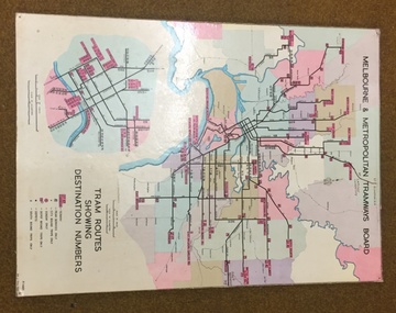 Melbourne Tram Museum
Map, Melbourne & Metropolitan Tramways Board, Del J. Chau, "Tram Routes showing destination numbers", 1972
Titled "Tram Routes showing destination numbers". Map dated 1972, showing routes with route numbers, including short working, names of main destinations, roads, railway stations and rail lines, municipalities, rivers, scales, city section in detail, depots and Sunday only services. In bottom right hand corner has number P.14431, Del J. Chau 1972. The original has been altered to show the Bundoora, La Trobe University and East Burwood lines and the change to Airport West. Type of map that was placed on the rear of the driver's doors of a W Class tramcar.Demonstrates a MMTB produced map used in trramcars.Full colour map or poster printed on heavy cardboard.trams, tramways, mmtb, map, routes -
 Wangaratta RSL Sub Branch
Mixed media - Framed Map and Newspaper, Peter Muncey, 23/7/1943
Sketch Map of Bulldog-Wau Road New Guinea drawn to scale by 2/1 Aust Fd Coy dated 23.7.43 and signed by soldiers together with related newspaper article. Hand sketched by Peter Muncey VX10042 a Draughtsman who served in the Middle East Ceylon and New Guinea with the 2/2 and 2/1 Field Coy Royal Australian Engineers. The sketch contains 26 signatures including:- S/Sgt Raymond Hector Ibbotson NX14112 who served in the Middle East and New Guinea Lt Col Jack Graham Wilson NX 130646Bulldog Track also known as Bulldog-Wau road was longer, higher, steeper, wetter, colder and rougher than Kokoda Track. In 1943 Australian Army engineers; the 2/1 and 2/16 Field Company RAE, 9th Australian Field Company (AIF), veterans of Syria, Palestine, Egypt, Greece and Crete, the 1st and 3rd Australian Pack Transport Companies and local Papuan labour cut the road with pickaxes and dynamite over a period of eight months. During five months of operations over seventy per cent of the 2/1 Australian Field Company contracted malaria.Seventeen bridges were constructed; mostly single, but at least one with multiple spans. More than two thousand Australian army personnel and over two thousand Papuans and New Guineans were involved during nine months of construction. Thus the road, acclaimed as the greatest military engineering feat ever, was completed and for the only time in history motor vehicles crossed the high rugged mountains of Papua New Guinea. Carved brown timber frame with cream mount containing hand sketched map with soldiers signatures and two newspaper articles.Sketch Map of Bulldog-Wau Road 23.7.43 2/1 Aust Fd Coy Newspaper - Diggers pushed on with pick and shovelbulldog-wau road, map, new guinea, ww2, 2/1 aust field coy -
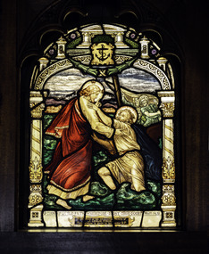 Mission to Seafarers Victoria
Artwork, other - Stained glass window, Brooks Robinson & Co et al, Thou of little Faith, 1917
This window along with the the second window in the reredos was donated by the Misses Forge in memory of their brother, James Leslie Forge, 33yo, who died on the 23 April 1917 while working on his orchard in Wingello, NSW. A Footscray local, he had donated the funds (100 pounds) for the reredos of the St Peter chapel. Follow Me and Thou of little Faith in the Sanctuary of the Chapel were probably installed at or around the time that the building was erected. The windows are attributed to Brooks, Robinson & Co. on stylistic grounds, probably designed by William Wheildon and drawn up into a full scale cartoon by George H. Dancey c1918.Arched stained glass windows with design and texts from St. Matthew’s Gospel reference water by showing the Sea of Galilee and Christ stilling the water. The ornamental borders have the anchor of hope in the point directly central above the scene.‘Thou of little Faith Wherefore dost thou doubt’ Matt. 4.31 / To the Glory of God, and in loving memory of / J. Leslie Forge / This window is given by his sister R.F.altar, st peter chapel, flinders street, mission to seafarers, seamen's mission, mission to seamen, st peter, sailors, seamen, anchor, stained glass windows, win, 1917, ww1, memorial chapel, reredos, footscray, james leslie forge, ruby forge, forge's store, gifts-1917 -
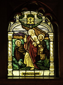 Mission to Seafarers Victoria
Artwork, other - Stained glass window, Brooks Robinson & Co, Follow Me, 1917
This window along with the the second window in the reredos was donated by the Misses Forge in memory of their brother, James Leslie Forge, 33yo, who died on the 23 April 1917 while working on his orchard in Wingello, NSW. A Footscray local, he had donated the funds (100 pounds) for the reredos of the St Peter chapel. Follow Me and Thou of little Faith in the Sanctuary of the Chapel were probably installed at or around the time that the building was erected. The windows are attributed to Brooks, Robinson & Co. on stylistic grounds, probably designed by William Wheildon and drawn up into a full scale cartoon by George H. Dancey c1918.Arched stained glass windows which design and texts from St. Matthew’s Gospel reference water by showing the Sea of Galilee and Christ stilling the water. The ornamental borders have the anchor of hope in the point directly central above the scene.‘Follow Me and I will make you fishers of men ‘ Matt. 4.19 / To the Glory of God, and in loving memory of J. Leslie Forge / This window is given by his sister E.F.altar, st peter chapel, flinders street, mission to seafarers, seamen's mission, mission to seamen, st peter, sailors, seamen, anchor, stained glass windows, win, 1917, ww1, memorial chapel, reredos, footscray, james leslie forge, edith forge, forge's store, gifts-1917