Showing 3734 items
matching street map
-
 Port Melbourne Historical & Preservation Society
Pamphlet - South Melbourne - Port Melbourne Historical & Preservation Society, "A walk around Port Melbourne", c. 1980
South Melbourne - Port Melbourne Historical & Preservation Society was in operation from the 1970s for approximately 20 years1980s information pamphlet as a guided walk around Port Melbourne. Produced by the South Melbourne - Port Melbourne Historical and Preservation Society. Map on front cover ; pink paper.built environment, heritage, recreation, south melbourne - port melbourne historical & preservation society -
Port Melbourne Historical & Preservation Society
Photograph - Woman in 'Australian' fancy dress related to a Swallow and Ariell Busy Bee event, 1914 - 1920
Probably from a "Busy Bee" novelty night like those held on 11 June 1915 (http://nla.gov.au/nla.news-article91164843) and 30 June 1916 (http://nla.gov.au/nla.news-article91165168).One of 44 black and white photos recording the work and contribution by Swallow & Ariell's "Busy Bee" for the First World War in Europe .39 - Woman in fancy dress based on an Australian flag and wearing a head dress of an Australian map with "Busy Bee's" and a bee hive emblazoned.built environment - industrial, business and traders, war - world war i, social activities, busy bee, swallow & ariell ltd, red cross -
Port Melbourne Historical & Preservation Society
Book, Meyer Eidelson, "Yalukit Willam - The River People of Port Phillip", Feb 2015
Written as part of the City's reconciliation program and with the assistance of Carolyn Briggs over a two year program."Yalukit Willam - The River People of Port Phillip" by Meyer Eidelson: illustrated soft cover, 99 pages plus fold out map at back cover is WFE Liardet watercolour of Emerald Hill corroboree and history of Koori activity pre and during European occupationSigned IFC by author, and Carolyn Briggs, Boon Wurrung Foundation, "yours with respect"australian aborigines, parks and gardens, natural environment, meyer eidelson, carolyn briggs, derrimut, yalukit willam clan, boon wurrung, kulin nation, bunjil, george robinson, ben bow, louisa briggs, wilbraham frederick evelyn liardet, wfe liardet, josephine liardet, emerald hill, william buckley, kurburu (the bear) -
Port Melbourne Historical & Preservation Society
Book, Meyer Eidelson et al, Walks in Port Phillip - A guide to the cultural landscapes of a city, Jan 2001
Book produced under a Federation grant. Five of the trails are associated with benches located on the foreshore.'Walks in Port Phillip - A guide to the cultural landscapes of a city' by Meyer EIDELSON. Small blue soft-cover book with seven guided walks and maps. 2001. 82pp with fold-in back coverSigned by author on title page 'Meyer'piers and wharves - station pier, immigration, piers and wharves - lagoon pier, utilities - gas, swallow & ariell ltd, natural environment - beaches and foreshore, natural environment - lagoon, liardet family, australian aborigines, meyer eidelson, vincenzo coluccio, rosa coluccio, pat grainger, gasworks -
Port Melbourne Historical & Preservation Society
Essay, Nancy U'REN, The Early Growth and Deveopment of Sandridge, 1976
The Early Growth and Deveopment of Sandridge, by Nancy U'REN 1976 - Master of Arts degree thesis containing early maps and photographs. Bound; dark blue cover with title lettered in gold on spine.local government - borough of sandridge, built environment, nancy u'ren nee morris -
Port Melbourne Historical & Preservation Society
Pamphlet - Facilities, brief history and map, Port of Melbourne, Port of Melbourne, 1980
Eight pamphlets covering the facilities, brief history and map of the Port of Melbourne to 1980. Printed for use as handouts.melbourne harbor trust - port of melbourne authority, transport - shipping -
Port Melbourne Historical & Preservation Society
Booklet, John Kepert and the Aviation Historical Society of Australia, Fishermen's Bend - A Centre of Australian Aviation, 1989
Fishermen's Bend - A Centre of Australian Aviation - publication prepared on the 50th anniversary of Aeronautical Research Laboratory in association with the Aviation Historical Society of Australia. Included are a map and aerodromes, companies and aircraft which used Fishermen's Bend A second copy is held in the Transport - Air filetransport - aviation and aerodrome, fishermans bend, built environment - industrial, industry - manufacturing, engineering, john kepert, aeronautical research laboratory -
Port Melbourne Historical & Preservation Society
Document - Calendar, Fennell Street Cafe, c. 2014
DL size calendar from the Fennell Street Cafe (33 Fennell Street). White printing on brown background lovation map, address and phone number.business and traders - cafes and restaurants, fennell street -
Port Melbourne Historical & Preservation Society
Flyer - Westgate Park, Melbourne and Metropolitan Board of Works, 1990s
Folded coloured flyer with stylised drawing of West Gate Bridge and a heron in black. Green stripe to represent the park and blue for the river. Group of buildings on left representing the city. The colour scheme continues in the folded pages . Maps of park and area, plus artists representation.parks and gardens, west gate bridge, westgate park, mmbw, melbourne and metropolitan board of works -
Port Melbourne Historical & Preservation Society
Flyer, City of Port Phillip, City of Port Phillip, Community News Bulletin. No 1 July 1994, Jul 1994
First community news bulletin from new City of Port Phillip after amalgamation.City of Port Phillip, Community News Bulletin. No 1 July 1994 . A4 white flyer with blue printing text on one side and yellow and blue map of Port Phillip on reverse.local government - city of port phillip, des clark, lynne wenic, geoff vincent, jon hickman -
Port Melbourne Historical & Preservation Society
Flyer, Victorian Railways, Sandridge Rail Trail, 2005
Fold out flyer with black and white picture of train and three men on front cover. Back cover coloured image from Latrobe picture collection of park-like setting with steam train in background. Fold out section has history of railway, map, walk and ride descriptionstransport - railways, recreation, piers and wharves - station pier, piers and wharves - railway pier, hobson's bay railway company, melbourne and hobson's bay united railway company, montague street station, golden fleece hotel, st barnabas anglican church, north port station, lord raglan hotel -
Port Melbourne Historical & Preservation Society
Pamphlet - Brochure, International Container Terminal Services Inc, Victoria International Container Terminal (Vict), Melbourne Australia
Coloured advertising brochure with photo of three cranes at Webb Dock east on cover front. Back cover has world map showing locations of International Container Terminal Services Inc. Inside has photos and text about location, services and the company.maritime, piers and wharves - webb dock, victoria international container terminal, webb dock east -
Port Melbourne Historical & Preservation Society
Booklet, Open Space 2000. Bay to ranges, Caring for Port Phillip Bay. Now and into the future, 2000
"Caring for Port Phillip Bay. Now and into the future" Booklet with blue and white cover and coloured map of Port Phillip Bay and surrounding area.natural environment, maritime, port phillip bay -
Port Melbourne Historical & Preservation Society
Document - Time line, Pat Grainger, Activities and achievements during the first twenty months PMHPS, 1995
Collated by Pat GraingerActivities and achievements during the first twenty months PMHPS. A3 sheet. Reverse side has B&W map of part of Melbounesocieties clubs unions and other organisations, social activities, port melbourne historical & preservation society, pmhps -
Port Melbourne Historical & Preservation Society
Map, City of Port Melbourne. Parishes of melbourne South. Doutta Galla, c. 1930
City of Port Melbourne. Parishes of Melbourne South. Doutta Galla Copy of map circa 1930, showing Port Melbourne, Station and Town piers. Map is black on white paper with numbered red dots on most residential blocks. 1876 written in ballpoint on bottom - possibly date of first edition, before later additions.built environment, engineering department - city of port melbourne -
Port Melbourne Historical & Preservation Society
Map - VACCUUM Road Guide to Victoria
The Mathews family have been in continuous ownership of 395 Howe Parade (was 8 Howe Parade until 1964 when addresses re-assigned), Port Melbourne from 1938 to the present (Sept 2019)Six folders of assorted documents relating to the life of Alan Mathews and his family. Employment documents. Folder 4 has Motor car purchases, Registration, Licences & RACV Road map. VACCUUM Road Guide to Victoriatransport - motor vehicles, alan mathews, commonwealth aircraft corporation, cac -
Port Melbourne Historical & Preservation Society
Map, City of Port Melbourne, 1963 - 1992
Used by Port Melbounre CouncilMap, City of Port Melbourne (.01) July 1992 (.02) June 1983 (.03) December 1963engineering department - city of port melbourne -
Port Melbourne Historical & Preservation Society
Flyer, Suggested ring road around Port, 2018 - 2019
These items were collected by a PMHPS member during 2018-19 and they have been retained as a group of ephemeraVarious ephemera of local interest showing changes in community. . Flyer regarding proposed ring road around Port Melbourne. Map of proposed route and listing key contact people. Campaign by Social Media Realty.built environment, ring road, social media ready -
Port Melbourne Historical & Preservation Society
Map, Port Melbourne City Council, Port Melbourne - Our City, Our Life, Our Choice - No Amalgamation, Jun 1986
Port Melbourne - Our City, Our Life, Our Choice - No Amalgamation Map of area with names and addresses local government - city of port melbourne, amalgamation, frederick charles jackson, town clerks, liana thompson, mayors -
Port Melbourne Historical & Preservation Society
Map, Port Melbourne City Council, Port Melbourne - Our City, Our Life, Our Choice - No Amalgamation, Jun 1986
Port Melbourne - Our City, Our Life, Our Choice - No Amalgamation Proposal with City of Port Phillip map amalgamation, mayors, local government - city of port melbourne, local government - city of port phillip, liana thompson -
Port Melbourne Historical & Preservation Society
Document - Voters Rolls, District of Sandridge
Five (5) municipal electoral rolls(photocopies), District of Sandridge 1861; 1862; 1863; 1865; 1866 Photocopy of 1860 map, catalogue no 2083local government - borough of sandridge -
Port Melbourne Historical & Preservation Society
Document - Submissions, Barak Road and Beacon Road developments, 1972
22 stapled pages regarding Barak & Beacon Roads development. Submissions to Minister of Lands from Cr TURNER and Cr JULIER 1972. MMBW planning map. Fishermens Bend Productivity Group working committee notes. Drawings and plans for housing, notes on developments 1955 -1972built environment - public housing, built environment - domestic, local government - city of port melbourne, leslie stanley turner, raymond frank julier, perce mcguire white, perce white, w a borthwick -
Port Melbourne Historical & Preservation Society
Map - Navigation Charts, Port Melbourne, Williamstown and River Yarra, 1994
.01 - Navigation chart of Port Melbourne, Williamstown and River Yarra channels 1994. Chart No Aust 154 .02 - Navigation Chart of approaches to Melbourne. Chart No Aust 155 c1986sport - yachting, maritime, beacons -
Port Melbourne Historical & Preservation Society
Map - "The Township of Sandridge", Public Lands Office, 1859
Photocopy 1859 map of township of Sandridgelocal government - municipal district of sandridge, frank callaghan -
 Port Melbourne Historical & Preservation Society
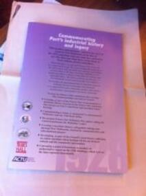
Booklet, Commemorating Port's Industrial History and Legacy, Feb 2011
Published to commemorate the anniversary of the 1928 waterfont lockout.Booklet with mauve background and black and white and dark red text. Back cover has map of "historic watersiders Port Melbourne walk"built environment, piers and wharves - princes pier, industrial disputes, allan whittaker, piers and wharves - waterside workers, maritime union of australia, mua, hogan's flat, beacon cove, james laurence murphy, george sangster -
 Port Melbourne Historical & Preservation Society
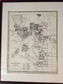
Map - Plan of Melbourne, 1855
Framed copy of 1855 "Plan of Melbourne and its suburbs". Black frame. Some writing can be seen on left hand side of print.built environment, melbourne and metropolitan board of works -
 Port Melbourne Historical & Preservation Society
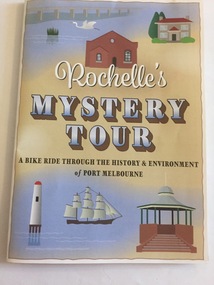
Pamphlet - Rochelle's Mystery Tour, bicycle tour of Port Melbourne identifying historic locations, Rochelle BELL, Rochelle's Mystery Tour, Jan 2017
Coloured 4 fold pamphlet with map, photographs of historic bike tour through Port Melbourne. Inside is large map marked with points of interest corresponding to photo and information on reverse sideRochelle's Mystery Tour a ride through the history and environment of Port Melbournebuilt environment, recreation, social activities, celebrations fetes and exhibitions, piers and wharves - princes pier, piers and wharves - station pier, rochelle bell, social health inclusion program (ship), danielle mccaffrey, centenary bridge, natural environment - beaches and foreshore, band rotunda, westgate park, lagoon reserve, liardet community centre, sandridge trugo club, garden city -
Port Melbourne Historical & Preservation Society
Book - Flannery Family History, Pros & Cons and Cops & Robbers, 2003
Pros & Cons and Cops & Robbers. Book of the Flannery Family history. Sepia and gold cover which is a map of "New Holland". Gold section has the name above words "Common men and women for an uncommon country". "A study through my ancestry by Robin Flannery with Frank Alcorta" Book inscribed on inside first page with names of the three Flannery girls and signed by the author. Latter part of book talks of family in Port Melbourne, including waterside workers, SP bookmaking and police.law, families, police, robin flannery, noelle kinsella, denise o'connor, rita may -
Port Melbourne Historical & Preservation Society
Map - Survey Map, Captain R Pasley R E, 24 Sep 1855
Survey map to accompany Colonial Engineers Report, September 1855melbourne -
Port Melbourne Historical & Preservation Society
Photograph - Woolsheds between Beacon and Barak Roads, Port Melbourne, Don Hossack, 1947
Donated by Don Hossack who took the photograph when he was 16 years old and working at the woolsheds. He recalls that bags of oats and barley were stored here.Photo (10 x 12" glossy black and white print) of the wool sheds between Beacon and Barak Roads. Shows north easternmost sheds and rail line. The wool sheds were built by the Americans during World War II and taken down again in the 1950s . Map (hand drawn) on rear shows location of photograph.map (hand drawn) of location of photographtransport - railways, built environment - industrial, war - world war ii