Showing 3759 items
matching surveyed
-
 Creswick Campus Historical Collection - University of Melbourne
Equipment
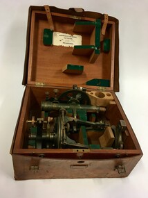
Surveying equipment in fitted timber box. 3 components of solid brass painted dark green. Missing one additional component. Outer fitted and hand tooled leather carrying case.EquipmentT.005 Ass.No.108B From Norman H.Seward, Optician 459 Bourke St (near Queen St.) Melbourne -
 Bendigo Military Museum
Administrative record - An analysis of Royal Australian Survey Corps mapping errors by Major LG Sam Thompson, Major LG Sam Thompson US Army Corps of Engineers at Army Survey Regiment, circa 1978
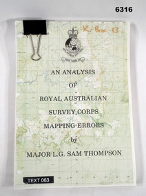
The purpose of the report is to analyze and study the map making procedures at the Army Survey Regiment to quantify the accuracy of the mapping to see if they meet acceptable accuracy standards. This was achieved through the study of possible errors.A4 loose leaf booklet held together with a "bulldog" paper clip. Cover part of an a RASvy 1:50,000 map. 1x Cover, 7x Introductory pages, 103x report pages.Marked on front cover "X - Box - 13", "TEXT 063"royal australian survey corps, rasvy, fortuna, army survey regiment, army svy regt, asr -
 Bendigo Military Museum
Photograph - Aerial Photography - Mohogany Ship Search Warrnambool Victoria, Victorian Lands Department, 3.1.1981
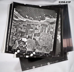
These Victorian Lands Dept Aerial Photographs were acquired by the Army Survey Regiment to help locate a Mohogany Ship wreck near Warrnambool Victoria as part of a unit Regimental Training ExerciseSeven Aerial photographic Prints and Film Negatives and positives of the same images. Images are Numbered 3562- 15,16,17,18,19, 29 and 30.royal australian survey corps, rasvy, fortuna, army survey regiment, army svy regt, asr -
 Bendigo Military Museum
Photograph - Lithographic Squadron Group Photos, Army Survey Regiment, Fortuna Villa, Bendigo, 1990
This is a set of 15 photographs of personnel posted to Lithographic Squadron at the Army Survey Regiment, Fortuna Villa, Bendigo Victoria, on the 1st of October 1990. These informal and formal group photos on the day of a CO’s Parade. It is not known why sunglasses were worn at the Squadron parade outside the Litho huts. Photos of the other three Squadrons, the Officers, and Warrant Officers/Sergeants from this set of negatives are catalogued in item 6440.11P. This is a set of 15 photographs of personnel posted to Lithographic Squadron at the Army Survey Regiment, Fortuna Villa, Bendigo Victoria, on the 1st of October 1990. The photographs are on 35mm negative film and were scanned at 96 dpi. They are part of the Army Survey Regiment’s Collection. .1) &.2) - Photo, black & white, 1990. OC MAJ Bob Coote. .3) - Photo, black & white, 1990. Front rank L to R: SPR Ken Labouchardiere, SPR Doug Whiteside, SPR Mark McCullogh. Centre rank L to R: SPR Andrew Woodman. Rear rank L to R: CPL Geoff Webb, CPL Daryl South. .4) - Photo, black & white, 1990. Front rank L to R: SSGT Russ Mollenhauer, SGT Kim Reynolds, SGT Brian Paul, unidentified, SPR Ken Labouchardiere, SPR Doug Whiteside, Centre rank L to R: SPR Graeme Spong, SPR Andrew Woodman. Rear rank L to R: SGT Steve Burke, CPL Geoff Webb. .5) - Photo, black & white, 1990. WO1 Trevor Osborne. .6) - Photo, black & white, 1990. LCPL Damien Cole. .7) - Photo, black & white, 1990. L to R: WO2 Rhys De Laine, WO2 Steve Egan, WO2 Keith Fenton RE UK Exchange, WO2 Rob Bogumil, WO1 Bill Jones. .8) - Photo, black & white, 1990. L to R: SPR Shane ‘Smily’ Campbell, SPR Andrew Woodman, CPL Daryl South. .9) - Photo, black & white, 1990. LT Greg Tolcher. .10) - Photo, black & white, 1990. SGT Steve Burke. .11) - Photo, black & white, 1990. Lithographic Squadron: Back row L to R: SPR Ross Anza, SGT Brian Fauth, unidentified, SPR Andrew Arman, SGT Gary Kerr, SPR Doug Whiteside, SSGT Russ Mollenhauer, CPL Peter Swandale, CPL Roy Hicks, SPR Shane ‘Smily’ Campbell, SPR Graeme Spong. Jones. 3rd row L to R: SSGT Garry Drummond, SGT Kim Reynolds, unidentified, SGT Brian Paul, CPL Gavin Mclean, SPR Mark McCullogh, CPL Le-Anne (Smallshaw) Shirley, CPL Geoff Webb, SPR Gary Lord, SSGT Di Chalmers, CPL Peter Dillon, LCPL Damien Cole, SGT Steve Burke. 2nd row L to R: SSGT Peter Imeson, SPR Gary Sievers, unidentified, CPL Daryl South, SPR Greg Howell, SPR Janet Murray, SPR Michelle Withers, SPR Ken Labouchardiere, SPR John Bragg, SPR Andrew Morrison-Evans, CPL John ‘Flash’ Anderson, CPL Trevor King. Front row L to R: WO2 Steve Egan, WO1 Trevor Osborne, LT Greg Tolcher, WO2 Rob Bogumil (standing), OC MAJ Bob Coote, LT Marty Lyons, WO2 Rhys De Laine, WO2 Keith Fenton RE UK Exchange, WO2 Jeff Willey. .12) & .13) - Photo, black & white, 1990. Lithographic Squadron: Back row L to R: SPR Ross Anza, SGT Brian Fauth, unidentified, SPR Andrew Arman, SGT Gary Kerr, SPR Doug Whiteside, SSGT Russ Mollenhauer, CPL Peter Swandale, CPL Roy Hicks, SPR Shane ‘Smily’ Campbell, SPR Graeme Spong. Jones. 3rd row L to R: SSGT Garry Drummond, SGT Kim Reynolds, unidentified, SGT Brian Paul, CPL Gavin Mclean, SPR Mark McCullogh, CPL Le-Anne (Smallshaw) Shirley, CPL Geoff Webb, SPR Gary Lord, SSGT Di Chalmers, CPL Peter Dillon, LCPL Damien Cole, SGT Steve Burke. 2nd row L to R: SSGT Peter Imeson, SPR Gary Sievers, unidentified, CPL Daryl South, SPR Greg Howell, SPR Janet Murray, SPR Michelle Withers, SPR Ken Labouchardiere, SPR John Bragg, SPR Andrew Morrison-Evans, CPL John ‘Flash’ Anderson, CPL Trevor King. Front row L to R: WO2 Steve Egan, WO1 Trevor Osborne, LT Greg Tolcher, WO2 Rob Bogumil, OC MAJ Bob Coote, LT Marty Lyons, WO1 Bill Jones, WO2 Rhys De Laine, WO2 Keith Fenton RE UK Exchange, WO2 Jeff Willey. .14) - Photo, black & white, 1990. L to R: WO2 Rob Bogumil, unidentified, OC MAJ Bob Coote, CPL Daryl South, unidentified (x3), CPL Roy Hicks, SSGT Di Chalmers, WO2 Jeff Willey, WO2 Keith Fenton RE UK Exchange, SPR Ken Labouchardiere, WO2 Rhys De Laine. .15) - Photo, black & white, 1990. L to R: SPR Greg Howell, SPR Gary Sievers, unidentified, SPR Ross Anza, unidentified (x4), SSGT Russ Mollenhauer, SPR Doug Whiteside, SGT Brian Paul, unidentified (x7), WO2 Jeff Willey, unidentified, WO2 Keith Fenton RE UK Exchange, WO2 Rhys De Laine, SPR Shane ‘Smily’ Campbell..1P to .15P – no annotationsroyal australian survey corps, rasvy, army survey regiment, army svy regt, fortuna, asr, litho sqn -
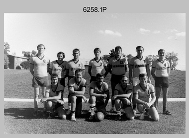 Bendigo Military Museum
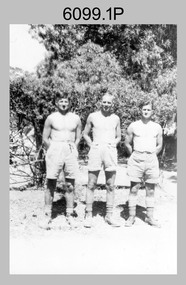
Photograph - Bones Day - Army Survey Regiment Versus RAAF School of Radio. Fortuna, Bendigo, c1982
These four photographs were taken at Bones Day, an annual sports competition between the Army Survey Regiment and the RAAF School of Radio at Bendigo c1982. The two units took turns each year to host the event. The day competition usually comprised basketball, cross country, golf, sailing, squash, softball, tennis, touch football, rifle shooting, tug-of-war and volleyball. The two sports featuring in these photos are touch football and tug-of-war. The “big bone” trophy comprising a large bone from a beast housed inside a wooden framed glass case, was awarded to the winner of the day competition. The evening competition often included darts, carpet bowls, hookey, quoits and billiards/snooker. The “little bone” (a mounted chicken bone) was the consolation trophy awarded to the winner of the evening competition. The 3-hour bus trip for the visiting unit on their return was typically very raucous. The history of the Bones Day competition is best described in the booklet titled - Bones of Contention Souvenir Program. 1965. Refer to Item 6267.These four photographs were taken at Bones Day, an annual sports competition between the Army Survey Regiment and the RAAF School of Radio at Bendigo c1982. The photographs are on 35mm negative film. They are part of the Army Survey Regiment’s Collection. The photographic negatives were scanned at 96 dpi. There are additional photos in this set that have not been scanned due to poor quality or low historical value. .1) - Photo, black & white, 1982, Touch Football Team Back Row L to R: Brian Fauth, Bruce Bowers, Bob Mason, Paul Baker, Danny Galbraith, John Hook, Scott Payne. Front Row L to R: Roy Hicks, Peter Imeson, Alan Glanville, John Gilbert, Wally Chilcott. .2) - Photo, black & white, 1982, Tug-of-War Team Back Row L to R: Cliff Webb, Peter Treble, John Lane, Andy Wilson, Rick Warren, Rusty Williams, Brian Paul. Front Row L to R: Brian Fauth, Rick Downie, unidentified, Ken Slater, Rhys De Laine, John Smith, unidentified. .3) - Photo, black & white, 1982, Tug-of-War Team L to R: Peter Treble, Brian Paul, Rusty Williams, Rhys De Laine, unidentified (2), John Smith. Army personnel in background standing L to R: Rick van der Bom, Paul Hopes, Ian Nelson, Mick Dempster, John ‘Flash’ Anderson, Geoff Havelberg, John ‘Stormy’ Tempest, Bruce Gordon, Dan Cirsky, Neil Jones, Gerry Gates, Peter Main, Bob Thrower, Barry Miller, Gill Park. Army personnel in background seated L to R: Roger Pearson, Mick Gillham, Penny Knott, Leanne Shirley. .4) - Photo, black & white, 1982, Tug-of-War Team L to R: Rick Warren, Cliff Webb, Andy Wilson, Peter Treble, Brian Paul, Rusty Williams, Rhys De Laine, unidentified. Army personnel in background standing L to R: Rick van der Bom, Ian Nelson, Mick Dempster. .1P to .4P – No personnel are identified.royal australian survey corps, rasvy, army survey regiment, army svy regt, fortuna, raaf school of radio, bones day -
 Bendigo Military Museum
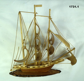
Souvenir - BOAT MODELS, 1962-72
The two models were collected from small village in South Vietnam by Geoff Murray No 3411521, Vietnam 3 Cav Regt 27.11.67 to 22.10.68, Survey Corp 15.10.69 to 15.10.70. Refer 638P..1 Model of a three masted ship made entirely of bamboo, mounted on a slice of timber. .2 Model of a two storey native stilt house with a tree made of a twig and painted polystyrene. Mounted on a slice of timber.handcrafts-sailor's craft, woodwork, vietnam, models -
 Tatura Irrigation & Wartime Camps Museum
Book, Soils and Land Use, 1963
Advice to land holders on how to use the Soil Survey Report. Soils and land use in the deakin Irrigation area, Vict, Technical Bulletin No. 16, Melb. Includes maps for Deakin Irrigation AreaCream cover, black writing, Techical Bulletin No. 16soils and land use, tatura, irrigation, books, technical, rural, industry -
 Robin Boyd Foundation
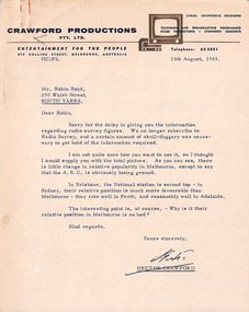
Letter, Hector Crawford, Letter from Hector Crawford to Robin Boyd, 13.08.1963
Letter from Hector Crawford, Managing Director of Crawford Productions, and attached document provides information regarding 1963 radio survey figures (ratings) gauging relative popularity of stations in Australian cities.The Flying Dogtor" series was broadcast on Australian Television Network (later becoming the Seven Network) between February and April 1964 (see item D254 for schedule).Typewritten, quarto, one page letter. Attached document is 7 foolscap, typed pages.radio survey data, radio ratings, the flying dogtor, robin boyd, crawford productions -
 Bendigo Military Museum
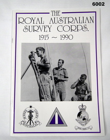
Booklet - Booklet Royal Australian Survey Corps History, " The Royal Australian Survey Corps " 1915-1990, c, 1995
This article was presented as a paper to the 1990 Australian War Memorial History Conference to mark the 75th anniversary of the formation of the "Australian Survey Corps" on 1 July 1915. The Corps has since been renamed. Booklet, A4, 13 Pages, Cardboard Cover, Colour, Maps, Photographs, Black and White. Held together by metal staplesroyal australian survey corps, rasvy, fortuna, army survey regiment, army svy regt, asr -
 Bendigo Military Museum
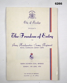
Booklet - City of Greater Bendigo Presents "The Freedom of Entry to Army Headquarters Survey Regiment", Army Headquarters Survey Regiment, 14.06.1970
This booklet is the program for the AHQ Survey Regiment Freedom of Entry to Bendigo on Sunday 14 Jun 1970 held at the Queen Elizabeth Oval, Bendigo. The ceremony was officiated by the Mayor of Bendigo Councillor CM JeffreyBooklet, B4 size, 11 pages, semi gloss paper, cover, red and blue text, contents, photos and text.army survey regiment, army svy regt, fortuna, royal australian survey corps, rasvy, asr -
 Federation University Historical Collection
Booklet, John Fraser, City of Ballarat 1856-1956, 1956
The Ballarat Municipality was established in 1856.Cream covered booklet covering a special meeting held to commemorate the 100th anniversary of the City of Ballarat Council. It includes a notice paper for a special meeting of Council, minutes of the Municipal Council of Ballaarat, first meeting, and images of the first survey of the Ballarat Township (1852), Ballarat in 1854, Central Ballarat in 1956, N. T. Callow and James Oddie. ballarat, council, ballarat east, ballaarat, munipality, ballarat townscape, sturt street, ballarat survey, yarrowee, paroompi, parmoompi, diggings -
 Federation University Historical Collection
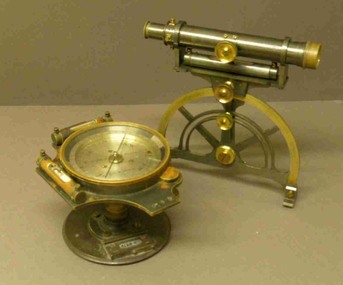
Instrument - Miner's Dial, c early 1900s
A miner's dial was used by surveyors to determine the direction of underground tunnels and roadways. The inclinometer allowed measurement of the angles at which mine tunnels descend into the ground.A rare miner's dial in a hinged timber box.This surveying instrument consists of a theodolite monsblr on a magnetic compass, which sits on the vertical tapered spigot of a base plate. Fits tripod catalogued item 4133. Inside the box lid is the supplier's label - W. Travill (successor to D. Esdale) of 146 Little Collins Street, Melbournemining, ballarat school of mines, surverying, scientific instruments, scientific objects -
 Bendigo Military Museum
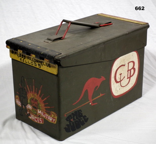
Container - AMMUNITION BOX
Box used by Anthony Robert Cornelius to take beer cans to the movies of a night in 1 ALSG Vietnam. Refer 1874.2 for his service history. Ammunition box, steel, green colour, rectangular shape. Item has been hand painted with various cartoon characters, signs, rising sun, kangaroo, military logos. A carry handle one one end. On the inside is a hand written list re service from Kapooka, Malaya, Vietnam to Army Survey Regiment Bendigo.“3176333 A.R. Cornelius “Kellogg’s”arms- ammunition, containers - commercial -
 Villa Alba Museum
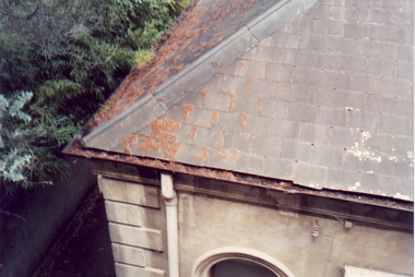
Photograph - Slate roof and guttering, c.1987
Built for William and Anna-Maria Greenlaw in the early 1880s, and with interiors decorated by the Paterson Bros, Villa Alba remained in private ownership until 1949. From 1950, the house was owned by a number of institutions. By 1984, the Villa Alba Preservation Society had been formed, and three years later, the Mount Royal Hospital granted a 25-year lease to Kew Council. In 2004, the title to Villa Alba was passed by the Victorian Government to The Villa Alba Museum Incorporated. The Museum, at 44 Walmer Street, Kew, is now a cultural institution committed to the collection, study and display of 19th century interior decorative finishes, and the components of 19th and 20th century interior decoration.This is one of a number of historically and aesthetically significant photos of the interiors and exterior of Villa Alba when it was still owned by the Mount Royal Hospital, showing twentieth century accretions and deterioration of the historic fabric of the building. This was a benchmark survey against which future conservation and restoration activities can be measured.In December 1987, Mockridge Stahle & Mitchell Pty Ltd Architects prepared ‘Villa Alba Survey: A Report on the fabric for Mount Royal Hospital’ of which this photograph is a part. Photo of one corner of the slate roof with evidence of slipped slates, rusted and blocked galvanised guttering and encroaching trees. This section of the roof is in the north west corner of the house.villa alba museum, conservation photographs, victorian architecture, slate roofs, gutters -
Bendigo Historical Society Inc.
Plan - MARKS COLLECTION: UNDERGROUND SURVEY MR. DENNIS CLAIM NEW CHUM
Plan on heavy parchment. On top of plan 'underground survey Mr. Dennis, New Chum' Signed: Thomas Forbes, Surveyor, 11th. January 1867. shows surface boundary of Dennis and Bonati. Written in blue pencil 'From nail in sapling 33f. 51/2 to boundary. On line to drill hole' Shaft marked on LH boundary.bendigo, mining, mr. dennis claim, new chum -
Bendigo Historical Society Inc.
Map - HEATHCOTE : COUNTY OF BENDIGO, 11-4-35
Map. Heathcote, County of Bendigo, County of Dalhousie,Township of Heathcote, McIvor Creek, Argyle Station Ground, Wallan and Bendigo Railway, C.R.B. Main Road. By authority H.J. Green, Govt. Printer. Photo-Lithographed at the Department of Lands and Survey, Melbourne. 11-4-35. Price 2/-. (number 88 in map cupboard 1)H.J. Green, Govt.Printermap, bendigo, heathcote -
Bendigo Historical Society Inc.
Map - PANNOOBAMAWM : COUNTY OF BENDIGO, 1957
Map. Pannoobamawm, County of Bendigo, Turrumberry, Terrick Terrick East, Wanurp, Pannoomilloo, Bamawm, Elmore to Cohuna Railway, McColl Station Ground, Lockington Station Ground. By authority W.M. Houston, Government Printer, Melbourne. Drawn and reproduced at the Department of Lands and Survey, Melbourne 1957. Price 2/-. (number 80 in map cupboard 1)W.M. Houston, Government Printer, Melbourne.map, bendigo, pannoobamawm -
Bendigo Historical Society Inc.
Map - MARONG : COUNTY OF BENDIGO, 25-6-25
Map. Marong, County of Bendigo, Nerring, Sandhurst, Lockwood, Shelbourne, Woodstock, Leichardt, Kangaroo Flat Rifle Range, Crusoe Aqueduct. By authority H.J. Green, Government Printer, Melbourne. Photo-Lithographed at the Department of Lands and Survey, Melbourne by W.J. Butson 25-6-25.Price 1/-. (number 75 in map cupboard 1)H.J. Green, Government Printer, Melbourne.map, bendigo, marong -
Bendigo Historical Society Inc.
Map - GOORNONG : COUNTY OF BENDIGO, 27-10-25
Map. Goornong, County of Bendigo, Egerton, Nolan, Ellesmere, Bagshot. Town of Goornong, Northern Railway. Campaspe, Muskerry, Campaspe River. Photo-Lithographed at the Department of Lands and Survey, Melbourne by W.J. Butson, 27-10-25,Price 1/-. By authority: H.J. Green, Government Printer, Melbourne. (number 43 in map cupboard 1)H.J. Green,Govt.Printer, Melbourne.map, bendigo, goornong -
Bendigo Historical Society Inc.
Map - SALISBURY WEST : COUNTY OF BENDIGO, 24-6-24
Map. Salisbury, County of Bendigo, County of Gladstone, Powlett, Yarrayne, Bridgewater, Inglewood, Glenalbyn, Kurting, River Loddon, Bulabul Creek. By authority A.J. Mullett, Government Printer, Melbourne. Photo-Lithographed at the Department of Lands and Survey, Melbourne by W.J. Butson, 24-6-24. Price 1/-. (number 116 in map cupboard 1)A.J. Mullett, Government Printer, Melbourne.map, bendigo, salisbury west -
Bendigo Historical Society Inc.
Map - HAWKESTONE : COUNTY OF BENDIGO, 7-11-15
Map. Hawkestone, County of Bendigo, County of Talbot, Lyell, Sutton Grange, Redcastle, Elphinstone, Metcalfe, Coliban River, Myrtle Creek. Albert J. Mullett, Government Printer, Melbourne. Photo-Lithographed at the Department of Lands and Survey, Melbourne by W.J. Butson,7-11-15. Price 1/-. (number 111 in map cupboard 1)Albert J. Mullett, Government Printer, Melbourne.map, bendigo, hawkestone. -
Bendigo Historical Society Inc.
Map - MUSKERRY : COUNTY OF BENDIGO, 1962
Map. Muskerry, County of Bendigo, County of Rodney, Goornong, Ellesmere, Axedale, Weston, Crosbie, Toolleen, Campaspe, Forest or Mannering Creek, Back Creek, Campaspe River. By authority A.C. Brooks, Government Printer, Melbourne. Drawn and reproduced at the Department of Lands and Survey, Melbourne, 1962. Price 2/-. (number 110 in map cupboard 1)A.C. Brooks, Government Printer, Melbourne.map, bendigo, muskerry -
Bendigo Historical Society Inc.
Map - HARCOURT, December 1951
Harcourt, County of Bendigo, Walmer, Castlemaine, Sutton Grange. Mt.Alexander Trig. Station, Barkers Creek, Faraday, Calder Highway, Northern Railway. By Authority J.J.Gourley, Government Printer, Melbourne,Drawn and Reproduced at the Dept. of Lands and Survey, Melbourne, Victoria. December 1951. Price 5/-per sheet. (number 35 in map cupboard 1)J.J.Gourley, Government Printer, Melbourne.map, bendigo, harcourt -
Bendigo Historical Society Inc.
Map - CAMPBELL COLLECTION: BENDIGO AND DISTRICT MAPS, 1962
Map. Mandurang, County of Bendigo. Scale 40 chains to 1 inch. Sandhurst, Strathfieldsaye, Sedgwick, Sutton Grange, Ravenswood, Lockwood, Township of Kangaroo Flat, Township of Mandurang. By Authority A.C. Brooks, Government Printer, Melbourne. Drawn and Reproduced at the Department of Lands and Survey, Melbourne,1962, Price 2/-. (number 401 in map cupboard 1)A.C. Brooks, Government Printer.map, bendigo, allotments -
 Bendigo Historical Society Inc.
Document - AULSEBROOK COLLECTION: FUNERAL PAMPHLET, 1970
Aulsebrook Collection: Funeral Pamphlet Title: Funeral of the late Lieutenant Colonel Lionel Bernard Sprenger, MBE, Commanding Officer, Amry Headquarters Survey Regiment, 11th- March 1920 - 5th December 1970 -A5, 2 pages (also folds out but no extra pages of information). -Order of service for the funeral including, songs, tributes and readings. -
 Bendigo Historical Society Inc.
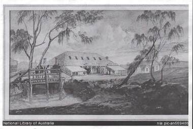
Photograph - BENDIGO POST OFFICE 1854
Photo: copy of photo of first Bendigo Post Office and Survey Office, located corner of Mitchell and Pall Mall. Building constructed by John Pyke, land purchased for 1800 pounds in first land sales. Source of information: Dr. Ralph Birrell. This reproduction is the property of the National Library of Australia, and is not for reproduction in any form apart from for research.bendigo, buildings, post office and survey office -
 Bendigo Military Museum
Card - XMAS CARD, C.1969 - 71
Hand written inside. "Murray, I will never forget you, how are you? I hope you are always well! My regards to your mother. I hope to one day see you again in V.Nam. Sister Augustine". The card relates to Geoff Murray No 3411521, 3 Cav Regt Vietnam 27.11.67 to 22.10.68, Survey Corp Vietnam 15.10.69 to 15.10.70. On his 2nd tour with Survey Corp Geoff procured a lot of food etc for the Baria Orphanage. Refer 610.2P, 611.8, 1866.3 re the Orphanage and Sister Augustine also 638P.Christmas card with river scene painted on front. .1) Heavy card outer pages. .2) Fine tissue paper inner pages..1) "Greetings" .2) "Merry Christmas and Best Wishes for a Happy New Year"cards, xmas, vietnam -
 Bendigo Military Museum
photograph - Fortuna - 1st Year of Army Occupation in Bendigo, 1942
This is a set of 17 photographs taken during the first year of Army occupation at Fortuna, Bendigo in 1942. The photos provide an insight into the preparatory work performed on the Fortuna Villa and surrounding buildings, by the Working Party 5th Army Troop and Ordnance Training Depot, before its occupation by personnel from LHQ Cartographic Company, Royal Australian Survey Corps. The annotation on the back of Photos .9P and .10P is misspelt. The correct spelling is ‘Nell Gwynne’. The poppet head of the Central Nell Gwynne mine is still an iconic landmark in Bendigo, lying just down the road from the poppet head lookout at Victoria Hill. The Central Nell Gwynne was the premier mine of Bendigo's 1930s mining revival and is of high historical value, due to the extensive and relatively intact features which remain at the site. The annotation on the back of Photo .17P is incorrect. The location of HQ 5th Army Troop was ‘Reynard St, Coburg.’ By late 1941 as Japan extended its control throughout Indo-China, resolving the accommodation problem of AHQ Cartographic Company located in Melbourne became more urgent. The steady Japanese advance made the bombing of Melbourne no longer a remote possibility, and in accordance with a general policy of dispersion, the Deputy Chief of the General Staff, Major General Sidney Rowell instructed Major William Sarll, in the interests of security of plant and to provide against possible damage of air attack, to investigate suitable safer inland accommodation for AHQ Cartographic Company. Major Sarll inspected many properties before finding one that would meet the requirements of the Cartographic Company. In late 1941, he came to inspect Fortuna, a rambling old mansion with about fifteen acres of ground in central Bendigo. Initially there was no intention to occupy the site beyond the end of the war, although Major Sarll's report to the Director of Survey noted many advantages in moving the Company to Bendigo. Major General Rowell quickly approved the selection of Fortuna before other authorities, which were investigating the evacuation of school children, could get in ahead of the Cartographic Company. On 23 March 1942, the Commonwealth of Australia, under the provisions of the National Security Act of 1939, took possession of the house, the old battery buildings and the fifteen acres of grounds. Under Warrant Officer J. Trist’s direction, over fifty Parks and Works tradesmen completed building works necessary to accommodate the Survey Corps’ military, map making and printing requirements. The building program was still under way when the first officer, Lieutenant Ralph Westgarth, arrived in May 1942 with the advance party which received and positioned all equipment as it came up from Melbourne in semi-trailers. Once the equipment was installed the rest of the Cartographic Company completed its shift to Bendigo by 11th June 1942. The first year of the Survey Corps’ occupation of Fortuna is covered in more detail with additional historic photographs, in pages 17-22 of Valerie Lovejoy’s book 'Mapmakers of Fortuna – A history of the Army Survey Regiment’ ISBN: 0-646-42120-4.This is a set of 17 photographs taken during the first year of Army Occupation at Fortuna, Bendigo in 1942. The black and white photographs were printed on photographic paper and are part of the Army Survey Regiment’s Collection. The photographs were scanned at 300 dpi. .1) - Photo, black & white, 1942. Bendigo Parks and Works tradesmen at Fortuna. L to R: Cliff Day, Ernie Arnold, Norm? .2) - Photo, black & white, 1942. “Don” - possibly SGT Don Sutcliffe. Fortuna, Bendigo. .3) - Photo, black & white, 1942. Parks and Works tradesmen in garden at Fortuna, Bendigo. L to R: Fred & Ernie. .4) - Photo, black & white, 1942. Benny Jack Williams at Fortuna, Bendigo. Accommodation tents were erected above the lake, which later became the parade ground. .5) - Photo, black & white, 1942. Working dress - Giggle suits. Parks and Works tradesmen at Fortuna, Bendigo. L to R: Cliff and Harry on big roof. .6) - Photo, black & white, 1942. Parks and Works tradesmen at Fortuna, Bendigo. Ted on big roof. .7) - Photo, black & white, 1942. Gold crusher battery just behind Fortuna. .8) - Photo, black & white, 1942. Scene of Bendigo from Fortuna. .9) - Photo, black & white, 1942. Nell Gwynne Mine from mullock heap at Victoria Hill near Fortuna, Bendigo. .10) - Photo, black & white, 1942. Nell Gwynne Mine and crusher near Fortuna, Bendigo. .11) - Photo, black & white, 1942. Sluicing for gold at Eaglehawk. .12) - Photo, black & white, 1942. Fortuna, Bendigo taken from the far side of tennis courts. .13) - Photo, black & white, 1942. Fortuna, Bendigo & its reflection from across the lake. .14) - Photo, black & white, 1942. Fortuna, Bendigo from the fishpond. .15) - Photo, black & white, 1942. Fortuna, Bendigo. .16) - Photo, black & white, 1942. First Fortuna Football Team at unknown location. L to R: 5th Bob Wright, 11th SGT Don Sutcliffe. .17) - Photo, black & white, 1942. Working Party from 5th Army Troop and Ordnance Training Depot at Fortuna, Bendigo.Some personnel are identified. Annotated with date within photos. .1) – Annotated on back ‘Cliff, Ernie, Norm, Dec ‘42. Cliff Day - dairy farmer, plasterers’ labourer. Ernie Arnold – hard plasterer. Norm? - QM Store for tools etc. QM Store was the Stables.’ .2) - Annotated on back ‘Don. Fortuna 1942’ .3) - Annotated on back ‘Fred & Ernie. Dec 1942. Carpenters. Note the state of the gardens.’ .4) - Annotated on back ‘Benny Jack Williams Fortuna Bendigo. Tents were erected where present day parade ground is above the lake.’ .5) - Annotated on back ‘Working dress - Giggle suits. June 42. Cliff and Harry on big roof. This photo was taken as the ventilating ridge was being installed on the building housing the printing machines. The machines were installed later by civilian labour when building was complete.’ .6) - Annotated on back ‘Ted on big roof Fortuna Bendigo.’ .7) - Annotated on back ‘Gold crusher battery – Bendigo for slay heap – 1942. 12 stamp battery. Just behind Fortuna. Was working at night when the “Army” came to Bendigo. Later removed to “Coolgardie - WA. Present site of Southern Cross TV.’ .8) - Annotated on back ‘Scene of Bendigo from Fortuna. June 1942.’ .9) - Annotated on back ‘Nell Gwyne Mine from mullock heap (Victoria Hill) Sept 1942.’ .10) - Annotated on back ‘Nell Gwyne Mine and crusher September 1942.’ .11) - Annotated on back ‘Sluicing for gold at Eaglehawk. August 1942.’ .12) - Annotated on back ‘Fortuna Bendigo 1942. Taken from far side of tennis courts.’ .13) - Annotated on back ‘ “Fortuna” across the lake & reflection.’ .14) - Annotated on back ‘Fortuna from fishpond June 1942.’ .15) - Annotated on back ‘Fortuna Dec 1942.’ .16) - Annotated on front ‘X’ x2. Annotated on back First Fortuna Football Team 1942‘Bob Wright’, ‘SGT Don Sutcliffe’. .17) - Annotated ‘Working Party at Fortuna before one of the drafts’, Working Party 5th Army Troop and Ordnance Training Depot Showgrounds, now the Sportsground Bendigo’, ‘HQ of 5th Army Troop was Reynards Rd, Coburg.’royal australian survey corps, rasvy, army survey regiment, army svy regt, fortuna, asr -
 Kew Historical Society Inc
Plan, Melbourne & Metropolitan Board of Works : Borough of Kew : Detail Plan No.1561, 1905
The Melbourne and Metropolitan Board of Works (MMBW) plans were produced from the 1890s to the 1950s. They were crucial to the design and development of Melbourne's sewerage and drainage system. The plans, at a scale of 40 feet to 1 inch (1:480), provide a detailed historical record of Melbourne streetscapes and environmental features. Each plan covers one or two street blocks (roughly six streets), showing details of buildings, including garden layouts and ownership boundaries, and features such as laneways, drains, bridges, parks, municipal boundaries and other prominent landmarks as they existed at the time each plan was produced. (Source: State Library of Victoria). This plan forms part of a large group of MMBW plans and maps that was donated to the Society by Mr Poulter, City Engineer of the City of Kew in 1989. Within this collection, thirty-five hand-coloured plans, backed with linen, are of statewide significance as they include annotations that provide details of construction materials used in buildings in the first decade of the 20th century as well as additional information about land ownership and usage. The copies in the Public Record Office Victoria and the State Library of Victoria are monochrome versions which do not denote building materials so that the maps in this collection are invaluable and unique tools for researchers and heritage consultants. A number of the plans are not held in the collection of the State Library of Victoria so they have the additional attribute of rarity.Original survey plan, issued by the MMBW to a contractor with responsibility for constructing sewers in the area identified on the plan within the Borough of Kew. The plan was at some stage hand-coloured, possibly by the contractor, but more likely by officers working in the Engineering Department of the Borough and later Town, then City of Kew. The hand-coloured sections of buildings on the plan were used to denote masonry or brick constructions (pink), weatherboard constructions (yellow), and public buildings (grey). MMBW Detail Plan 1561 outlines those residences in the area bordered by Burke Road, Loxton Street, Mount Street and Barkers Road that had been constructed by 1905 when the land was surveyed. At this time, the area nearest Burke Road had been subdivided and developed whereas the lands to the west were as yet undeveloped. The houses represented are not named on the Plan.melbourne and metropolitan board of works, detail plans, mmbw 1561, cartography -
Bendigo Historical Society Inc.
Document - BENDIGO AND VICTORIA HILL REPORT ON GEOLOGY
Report, 8 pages, on the geology of Bendigo district and Victoria Hill, produced by the Geological Survey Dept., Victorian Government. G.J. Medwell, Geologist. 19.10.1967. On front 'Geological Survey of Victoria. Mines Department Victoria. Report on Geology of Bendigo and of Victoria Hill Area' Letter attached inside front cover to J.C.Balfour, Minister of Mines to G.A. Lambert, Liberal Party, Sunshine, Victoria, sent with book for his information. Report contains: Cobaw batholith and North Harcourt Bendigo goldfield generally Trought, reefs, saddles and spurs Victoria Hill mines; Victoria Consols, Great Central Victoria, Victoria Quartz, Lansells 180, North Old Chum. Maps attached show part of New Chum line of reef and a handdrawn map of Rae's Cutting.bendigo, mining, victoria hill, bendigo goldfield