Showing 2692 items matching "3rd"
-
 Flagstaff Hill Maritime Museum and Village
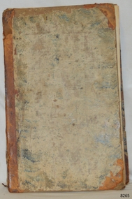
Book - Reference Book, Mr Salmon (Thomas Salmon) et al, Modern History: or, the Present State of All Nations. Vol III, 1746
The author was Mr. Salmon (Thomas Salmon), (1679-1788). The fly page of the book has the following writing in red and black print: "Describing their Respective Situations, Persons, Habits, and Buildings; Manners, Laws and Customs, Religion and Policy; Arts and Sciences, Trades, Manufacturers and Husbandry; Plants, Animals and Minerals. Illustrated with Cuts and Maps, accurately drawn according to the Geographical Part of this Work by Herman Moll. Third Edition with considerable Additions and Improvements, interspersed in the Body of the Work: Also the History and Revolutions of each Country, brought down to the present Time. " Thomas Longman founded his publishing firm in 1724 in London by the name Longman. In August of that year, he bought the two shops and goods of William Taylor and set up his publishing house there at 39 Paternoster Row. The shops were called Black Swan and Ship, and it is said that the 'ship' sign was the inspiration for Longman's Logo. After many changes of name and management, including the name T Longman and T Shewell in 1746. The firm was incorporated in 1926 as Longmans, Green & Co. Pty Ltd. The firm was acquired by Pearson in 1968 and was known as Pearson Longman or Pearson PLC. The book is part of Flagstaff Hill's Pattison Collection, a large group of books and records, some of which are rare and valuable. The collection was originally owned by the Warrnambool Mechanics' Institute, which was founded in 1853 and is named after Warrnambool's Public Librarian, Ralph Pattison.The book is significant for its age – it is one of the oldest books in Flagstaff Hill’s collection, published in 1746. The book is a record of Modern History at that time and allows studying and comparing those times with today. The book is important for its connection with the London publisher T Longman and T Sewell, who only operated under this name between 1745 and 1747. The firm has been established for over two centuries and is renowned for publishing encyclopedias, dictionaries, books on English grammar, textbooks, poetry, reference books, novels, magazines and more. The book has additional importance for its connection to the Pattison Collection, which, along with other items at Flagstaff Hill Maritime Village, was originally part of the Warrnambool Mechanics' Institutes’ Collection. The Warrnambool Mechanics’ Institute book collection has historical and social significance for its strong association with the Mechanics Institute movement and its important role in people's intellectual, cultural and social development throughout the latter part of the nineteenth century and the early twentieth century. The collection of books is a rare example of an early lending library and its significance is enhanced by the survival of an original collection of many volumes. The Warrnambool Mechanics' Institute’s publication collection is of both local and state significance.Modern History: or, the Present State of All Nations Vol III Author: Mr. Salmon (Thomas Salmon) Illustrator: Herman Moll Publisher: T Longman and T Shewell in Paternoster Row, London Date: 1746 (MDCCXLVI), 3rd Edition Further Information: In Three Volumes, Vol. III The large hardcovered book has reinforcing on the spine and corners. The cover is very well worn and has remnants of a coloured design. The fly page is printed in red and black ink and has a long description of the contents. Inside the cover is printed a Coat of Arms. There is a stocker on the inside cover, The book is part of the Pattison Collection.Label on the spine "RH F910 SAL" Sticker on the pastedown front endpaper "Corangamite Regional Library Service" Printed on pastedown front endpaper "Coat of arms, crown above a shield with an inverted V with three stars on it" Sticker on front loose endpaper "Coat of arms, with "F C G Ritso"flagstaff hill, flagstaff hill maritime museum and village, warrnambool, maritime museum, maritime village, great ocean road, shipwreck coast, pattison collection, ralph eric pattison, warrnambool mechanics’ institute, mechanics’ institute library, warrnambool library, free library, corangamite regional library service, mr salmon, thomas salmon, 18th century, 1746, history, geography, social studies, culture, maps, modern history, present state of all nations vol iii, herman moll, t longman and t shewell, social history -
 Glenelg Shire Council Cultural Collection
Photograph - Sheet of 12 contact prints - Various historic Portland buildings and Landmarks, c. 1970
Sheet of 12 contact prints of rephotographed photographs. Identifying number 5717 a, b, c, d, e, f, g, h, i, j, k, l (a) Nun's Beach with boats (b) 3rd Baths (c) Percy Street West, view from Henty Street (d) Percy Street, west, further along Street (e) Habrour from Whalers Bluff (f) Portland Gaol (g) Flagstaff and Lightkeepers Quarters, Observatory Hill (h) Claremont (i) First Portland Post Office building (j) Res Abraham Barrett, baker (k) Warehouses Trangmar & Crouch (l) Union Bank -
 Federation University Historical Collection
Book, Railway Practice: a collection of working plans and practical details of construction in the public works of the most celebrated engineers, 1847 (exact)
A green cloth hard cover book. Title and author's name are engraved in gold on spine. This is the 3rd edition, first series with black and white illustrations. It describes the engineering practices of the early days of British railroads. The book includes (series 1 to 4)and it contains, roads, tramroads and railroads, bridges, aqueducts, viaducts, wharfs, warehouses, roofs, and sheds, canals, locks, sluices, & the various works on rivers, streams, etc., harbours, docks, piers and jetties, tunnels, cuttings and embankments, the several works connected with the drainage of marshes, marine sands, and the irrigation of land, water-works, gas-works, water-wheels, mills, engines.civil engineering, railway practice, rail constructions, s c brees, western railway great britain, public works, railroads, canals, s.c. brees, samuel brees, samuel charles brees -
Federation University Historical Collection
March Cards, Once Upon a Time - music for brass band instruments, Early to mid 1900s
Frank Wright was a renown resident of Smeaton, where he was born on 2 August 1901. He lived at Laura Villa, and attended Smeaton State School. His father William was a gold miner and his mother's name was Sarah. Their family won many singing and instrumental awards. Frank was tutored by Percy Code and was awarded a gold medal for the highest marks in the ALCM examinations in the British Colonies at the age of seventeen years. He became the Australian Open Cornet Champion by the age of eighteen. A year later, Frank conducted the City of Ballarat Band, and later the Ballarat Soldiers’ Memorial Band. He formed the Frank Wright Frisco Band and Frank Wright and his Coliseum Orchestra. These bands won many South Street awards, and Frank as conductor won many awards in the Australian Band Championship contest. In 1933 Frank Wright sailed to England to conduct the famous St Hilda’s Band and was later appointed Musical Director of the London County Council, where he organized many amazing concerts in parks, in and around the London district. He was made Professor of Brass and Military Band Scoring and conducted at the Guildhall of Music and Drama. Frank was often invited to adjudicate Brass Band Championships around Europe, in Australia, including South Street and in New Zealand. The Frank Wright Medal at the Royal South Street competition is awarded to an individual recognized as making an outstanding contribution to brass music in Australia.Small cards of sheet music, scored for all the instruments in a brass band for the music entitled 'Once upon a time'. Most likely arranged and scored by Frank Wright. As in the style of the early part of the 1900's, the music was hand written, then copied. The instruments included are - 1). Soprano cornet, 2). Repiano cornet, 3). 2nd & 3rd cornets, 4). Solo & 1st horns, 5). 2nd horn, 6). Euphonium, 7). 1st & 2nd Baritones, 8). 1st & 2nd trombones, 9).Bass trombone, 10). E flat Bass, 11). B flat Bass and 12). Drums etc.frank wright, brass bands, march cards, once upon a time, sheet music -
 Bendigo Historical Society Inc.
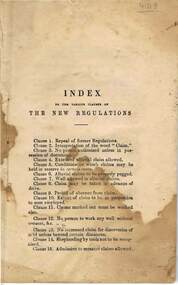
Book - INDEX TO THE VARIOUS CLAUSES OF THE NEW REGULATIONS - SANDHURST GOLDFIELDS
INDEX TO THE VARIOUS CLAUSES OF THE NEW REGULATIONS - SANDHURST GOLDFIELDS / small brown , string bound , stained paper booklet / page 1 shows SANDHURST GOLDFIELDS General Regulations - Chief Secretary's Office , Melbourne , 22nd August , 1856. 'His excellency the Officer administering the government , with the advice of the Executive Council , has approved and authorised the promulgation of the following General Regulations dated the 3rd of October , 1855 ) under the Act of Council 18 Victoria No. 37. By His Excellency's Command ,W.5044, William C Haines' - back page shows Argus Stationery Depot , Pike's Buildings , Pall Mall, Sandhurst.book, bendigo, argus stationery depot , pike's buildings , pall mall, sandhurst , /1871, english, book edition: rules and regulations of the bendigo mining exchange, 1871. bendigo mining exchange.///index to the various clauses of the new regulations - sandhurst goldfields -
 Bendigo Historical Society Inc.
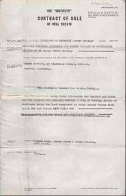
Document - H. A. & S. R. WILKINSON COLLECTION: CONTRACT OF SALE
Contract of sale of real estate dated 3rd December, 1964 between National Trustees Executors and Agency Company of Australasia as administrator of H. W. Bowden deceased (vendor) and Mr. C. Sartori (purchaser). Solicitor for vendor: Watson, James & Rogers, RACV Bldg. View Point, Bendigo. Solicitor for purchaser: Mr. H. E. Every, Dispensary Walk, Bendigo. Vacant land corner Grant & Priam Streets, Long Gully being Crown allotment 260 and 261 section A land comprised in Crown Grants volume 2195 folio 556 and volume 2190 folio 885. Price 225 pounds.organization, business, h.a. & s.r wilkinson real estate -
Bendigo Historical Society Inc.
Postcard - PORTRAIT 3 YOUNG CHILDREN
Postcard : Sepia portrait of 3 young children. A girl sitting on a wooden chair, wearing a white dress, white ribbon tied to the side of her dark colour hair, wearing long black socks and black shoes, bow tired. A boy standing arm leaning on a two tier table, wearing long black socks and black shoes with 3 straps buttoned, bow tie, striped and button shirt. The 3rd child sitting high on table, holding a Union Jack flag, wearing a dress that looks like a coat. On front of postcard reads Bendigo, on back it reads Kalna Bendigo.Kalna Bendigophoto, group, 3 young children, postcard, photograph, portrait, 3 young children. -
 Bendigo Historical Society Inc.
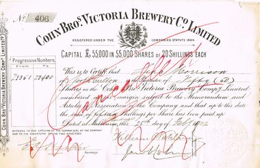
Document - COHN BROTHERS COLLECTION: SHARE SCRIP
a. Cohn Bros Victoria Brewery Co Limited Share scrip No 406 progressive numbers 23351-23400 of fifty shares held by Lina Morrison dated 25th day of February 1902. Capital £55,000 of 55,000 shares or twenty shillings each. E A Hasken secretary witnessed directors William Nahlaw and Jacob Cohn signing share document. .b Share Transfer document no 291 of fifty shares numbered consecutively 23351-23400 from Lina Morrison to Julius Cohn. Signed in the presence of W C Kennedy and J I Hasker on 3rd of October 1909. One penny stamp duty paid and affixedbendigo, industry, cohn bros brewery, con bros brewery. lina morrison. -
 Bendigo Historical Society Inc.
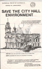
Document - JAMES LERK COLLECTION: SAVE THE CITY HALL ENVIRONMENT, 1971
Flyer from the National Trust of Australia Centtal Vic. Junior Group. "Save the City Hall Environment" ...You can destroy an important building by wrecking its environmental situation as you can by wrecking the building... In the middle of the page a drawing of the City Hall. Vote NO now; and reconsider another site at another time. Don't jeopardise the future of a classified "B" building. The flyer is signed by Mr R. Davidson, Chairman National Trust of Aust. Bendigo Advertiser 3rd July, 1971. Plus six small sign "save our city hall" in blue and one "saver our city square vote no on the library issue".national trust, properties, save the city hall environment -
 Bendigo Historical Society Inc.
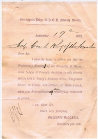
Document - QUARTZOPOLIS LODGE FRIENDLY SOCIETY LETTER
Copies of documents: 1.Copy of letter issued by the Quartzopolis Lodge Friendly Society on September 19th 1873 to Secretary Court King of the Forest. Letter details that a meeting of the delegates of the various Lodges of Friendly Societies in this district will be held at Ready's Rainbow Hotel, Hargreave (sic) Street on 3rd Octrober. Signed by Gillespic (sic) McDonell. 2. Widows and Orphans' Fund entrance fees (A.O.F, B.U.D) 3. Court King of the Forest application for Thomas White, blacksmith of Ironbark, age 28, one child. 4. Court King of the Forest No. 3770, Invoice Dr. H.L. Atkinson. Services July 19th 1871.bendigo, clubs, quartzopolis friendly society, court king of the forest; quartzopolis lodge, thomas white, dr. atkinson -
 Ballarat Tramway Museum
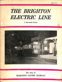
Book, Leon Marshall-Wood, "The Brighton Electric Line", 1966
Book - 40 pages including card covers - the history of the Brighton Electric Line by Leon Marshall-Wood, published 1966, 3rd edition revised and enlarged. Gives a brief history of the electric tramway operated by the Victorian Railways between St. Kilda Station and the Brighton Beach railway station, that commenced operation in 1905. Also a short history of the Sandringham - Black Rock - Beaumaris - Cheltenham tram electric and horse tram lines. Includes maps, rolling stock and ticket notes. Published by Traction Publications. Has details of the AETA on the back cover and listing of some publications. See Reg Item 1146 for 1956 edition.Has the stamp of the "Technical Book and Magazine Co" on front cover.trams, tramways, vr, melbourne, brighton, st kilda, sandringham, black rock, horse trams -
 Ballarat Tramway Museum
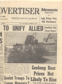
Newspaper, Geelong Advertiser, "Tramlines out, street repair", "Vandal damage tram to become scrap", 27/10/1959 12:00:00 AM
Newspaper clipping from the Geelong Advertiser, 27/10/1959. Page 1 - top right hand corner, article and photograph - "Tramlines out, street repair", of the removal of tram track in Aberdeen Street between Pakington Street and Latrobe St. Page 2 - top right hand corner, article and photograph - "Vandal damage tram to become scrap" - about the decision by the Newtown and Chilwell Council to give the tram in Queens Park to the 3rd Geelong Flinders Pioneers as scrap metal. Tram No. 38. Contained originally within Reg Item 5623 at the front of this note book. For items see btm5623 loose items list.pdf.geelong, closure, track removal, preserved trams, queens park -
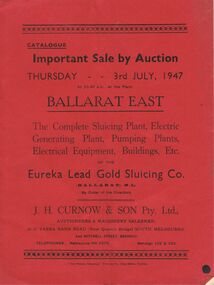 Bendigo Historical Society Inc.
Document - IAN DYETT COLLECTION: AUCTION CATALOGUE - EUREKA LEAD GOLD SLUICING CO
Red covered auction catalogue of Complete Sluicing Plant, Electric Generating Plant, Pumping Plants, Electrical Equipment, Buildings, Etc of the Eureka Lead Gold Sluicing Co. (Ballarat) N. L. on Thursday 3rd July, 1947 at the Plant, Ballarat East. Catalogue contains Conditions of Sale, 291 Lot numbers arranged in sections, e.g. Outside Engine House, Engine House, Outside Producer House, Transmission Line, At Sludge Pump, At Assay Office, Blacksmith's Shop, Assay Office and Pump Plant at Brown Hill. One catalogue has sale prices in pounds, shillings and pence beside each lot.business, auctioneers, j h curnow & son pty ltd, ian dyett collection - auction catalogue - eureka lead gold sluicing co (ballarat) n l, j h curnow & son pty ltd, the prahan telegraph printing co -
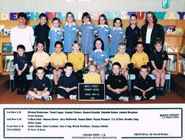 Bendigo Historical Society Inc.
Photograph - GOLDEN SQUARE MAPLE STREET P.S. COLLECTION: PHOTOGRAPH - GRADE PREP - 1K 1999
Coloured photograph of the Maple Street Primary School Grade Prep - 1K 1999 class and the teachers. Their names are: 3rd Row L-R: Michael Robertson, Tahni Logan, Jasmin Vickers, Kestrel Kentish, Danielle Stokes, Jasinta Bergman, Trent Jackson. 2nd Row L-R: Callum Muir, Sheena Dewar, Jory McDowell, James Elliott, Kayla Plunkett, T.J. O'Dea, Bradley Sing, Alissa Argus. Front Row L-R: Taelor Sloan, Jake Cardinal, Alex Craig, Brock Fordham, Zachary Ritchi. Teachers: W Neve, D Kent. Principal: Mr David Robins.Arthur Reed Photoseducation, primary, golden square laurel st p.s., golden square maple street p.s. collection - photograph - grade prep - 1k 1999, michael robertson, tahni logan, jasmin vickers, kestrel kentish, danielle stokes, jasinta bergman, trent jackson, callum muir, sheena dewar, jory mcdowell, james elliott, kayla plunkett, t.j. o'dea, bradley sing, alissa argus, taelor sloan, jake cardinal, alex craig, brock fordham, zachary ritchi, w neve, d kent, mr david robins, arthur reed photos -
 Bendigo Historical Society Inc.
Document - GOLDEN SQUARE LAUREL STREET P.S. COLLECTION: EXAMINATION CARDS
Four white photocopy examination cards laminated upon blue cardboard and printed, SS 1189 , Golden Square, years 1941-42. Each outlines numbered marks out of ten for student named Elaine Rudd for subjects, Reading, Recitation, Spelling, Writing, Composition, English, Arithmetic A-B-C-D, History, Geography, Handwork, Art. B Rutherford and F Baggaley signatures. Written note states, 'Position; 3rd in class of 45. Excellent result. Elaine has done good work all the year. She seems to be very interested in her school work. Initialled FB.bendigo, institutions, golden square primary school -
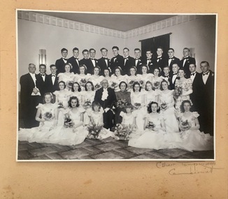 Kew Historical Society Inc
Photograph, Kew Mayoral Ball, Hawthorn Town Hall, 1947, 1947
Photograph of the first Kew Mayoral Ball to be held after the Second World War. The photograph formed part of the collection of WHS Dickinson and was presented to the Kew Historical Society by his daughter in 2018. A group portrait of attendees at the 1947 Kew Mayoral Ball, held in 1947 at the Hawthorn Town Hall. In the second row, centre are the Mayor and Mayoress of Kew, Cr WHS Dickinson and Mrs Doris Dickinson. Also in the photo are the acting Town Clerk of Kew, Bill Graham (3rd row at left), two flower girls, Judith and Janet Dickinson, and debutantes with their partners. Mr Ron Dickinson, the son of the Mayor and Mayoress is standing in the back row at left. The photograph is in a beige card folder embossed with the words "Portrait by C. Stuart Tompkins, Camberwell". The internal framing mount is signed in pencil with: "C Stuart Tompkins, Camberwell". 1947cr whs dickinson - mayor of kew 1946-1947, civic events - kew (vic), mayoral balls - kew (vic) -
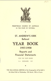 Federation University Historical Collection
Booklet, St Andrew's Kirk Ballarat year Book and Municipal Service, 1956-8
ITwo booklets relating to St Andrew's Kirk, Ballarat. .1)St Andrew's Kirk Year Book 1957-8. This booklet includes financial statements and reports such as The irk Session , Board Of Management, St Andrew's- Congoes tennis CLub, Floral Guild, P.F.A., Drama Group, Boys' Club, P.W.M.U. , Girl Girl Company, 3rd Brownie Pack, St Andrew's Kirk Choir, Ladies Guild, Sunday School. .2) Folded pamphlet for the St Andrew's Kirk Municipal Service, 16 September 1956 at 7pm. the service was conducted at the request of the mayor of the City of Ballaarat, Cr Kenneth C. Webbst andrew's kirk, presbyterian, boustead, bullock, clemence, coutts, crawford, punshon, barnes, chester, griffiths, sykes, taylor, tippett, thwaites, waller, webb, goddard, cowan, mcgregor, allen, spiers, ellerton, bell, eileen john, drew, annie draffin, vera mayo, clark chester -
 Eltham District Historical Society Inc
Photograph, Liz Pidgeon, Heritage Excursion; Maroondah Aqueduct, 3 September 2016, 3 September 2016
Newsletter No., 229, August 2016 Heritage Excursion - Maroondah Aqueduct Walk - Saturday 3rd September The Maroondah Aqueduct was once a major link in Melbourne’s water supply system. It was built between 1886 and 1891 to transfer water from the Watts River near Healesville to the Preston Reservoir. It was 66 km in length, made up of 41 km of open channel, 10 km of tunnel through hills and 15 km of pipeline across stream valleys known as inverted siphons. The section of the aqueduct through the Eltham area has been abandoned since the 1980s but the open channel has largely been retained. A recreational path follows the aqueduct reserve. For our excursion on 3rd September we intend to walk along the section of the aqueduct adjacent to Allendale Road. This is a section not visited on previous excursions and includes the transition from open channel to the inverted siphon across the Diamond Creek valley. Apart from the aqueduct itself the main feature of the walk is the extensive views across Eltham North and Diamond Creek. Along the way we will talk about the history of the aqueduct and the area. This easy walk is about 3 km return and will take 2 to 2.5 hours. It will start at 2pm at the junction of Allendale Road with Godber Road and Zig Zag Road North, officially Diamond Creek, but on the northern boundary of Eltham. (Melway ref.12 B10). Born Digitalmaroondah aqueduct, eltham north, activities, eltham district historical society, heritage excursion, acqueduct trail, sign -
 Eltham District Historical Society Inc
Photograph, Liz Pidgeon, Heritage Excursion; Maroondah Aqueduct, 3 September 2016, 3 September 2016
Newsletter No., 229, August 2016 Heritage Excursion - Maroondah Aqueduct Walk - Saturday 3rd September The Maroondah Aqueduct was once a major link in Melbourne’s water supply system. It was built between 1886 and 1891 to transfer water from the Watts River near Healesville to the Preston Reservoir. It was 66 km in length, made up of 41 km of open channel, 10 km of tunnel through hills and 15 km of pipeline across stream valleys known as inverted siphons. The section of the aqueduct through the Eltham area has been abandoned since the 1980s but the open channel has largely been retained. A recreational path follows the aqueduct reserve. For our excursion on 3rd September we intend to walk along the section of the aqueduct adjacent to Allendale Road. This is a section not visited on previous excursions and includes the transition from open channel to the inverted siphon across the Diamond Creek valley. Apart from the aqueduct itself the main feature of the walk is the extensive views across Eltham North and Diamond Creek. Along the way we will talk about the history of the aqueduct and the area. This easy walk is about 3 km return and will take 2 to 2.5 hours. It will start at 2pm at the junction of Allendale Road with Godber Road and Zig Zag Road North, officially Diamond Creek, but on the northern boundary of Eltham. (Melway ref.12 B10). Born Digitalmaroondah aqueduct, eltham north, activities, eltham district historical society, heritage excursion, acqueduct trail, diamond creek -
 Eltham District Historical Society Inc
Photograph, Liz Pidgeon, Heritage Excursion; Maroondah Aqueduct, 3 September 2016, 3 September 2016
Newsletter No., 229, August 2016 Heritage Excursion - Maroondah Aqueduct Walk - Saturday 3rd September The Maroondah Aqueduct was once a major link in Melbourne’s water supply system. It was built between 1886 and 1891 to transfer water from the Watts River near Healesville to the Preston Reservoir. It was 66 km in length, made up of 41 km of open channel, 10 km of tunnel through hills and 15 km of pipeline across stream valleys known as inverted siphons. The section of the aqueduct through the Eltham area has been abandoned since the 1980s but the open channel has largely been retained. A recreational path follows the aqueduct reserve. For our excursion on 3rd September we intend to walk along the section of the aqueduct adjacent to Allendale Road. This is a section not visited on previous excursions and includes the transition from open channel to the inverted siphon across the Diamond Creek valley. Apart from the aqueduct itself the main feature of the walk is the extensive views across Eltham North and Diamond Creek. Along the way we will talk about the history of the aqueduct and the area. This easy walk is about 3 km return and will take 2 to 2.5 hours. It will start at 2pm at the junction of Allendale Road with Godber Road and Zig Zag Road North, officially Diamond Creek, but on the northern boundary of Eltham. (Melway ref.12 B10). Born Digitalmaroondah aqueduct, eltham north, activities, eltham district historical society, heritage excursion, acqueduct trail, sign -
 Eltham District Historical Society Inc
Photograph, Liz Pidgeon, Heritage Excursion; Maroondah Aqueduct, 3 September 2016, 3 September 2016
Newsletter No., 229, August 2016 Heritage Excursion - Maroondah Aqueduct Walk - Saturday 3rd September The Maroondah Aqueduct was once a major link in Melbourne’s water supply system. It was built between 1886 and 1891 to transfer water from the Watts River near Healesville to the Preston Reservoir. It was 66 km in length, made up of 41 km of open channel, 10 km of tunnel through hills and 15 km of pipeline across stream valleys known as inverted siphons. The section of the aqueduct through the Eltham area has been abandoned since the 1980s but the open channel has largely been retained. A recreational path follows the aqueduct reserve. For our excursion on 3rd September we intend to walk along the section of the aqueduct adjacent to Allendale Road. This is a section not visited on previous excursions and includes the transition from open channel to the inverted siphon across the Diamond Creek valley. Apart from the aqueduct itself the main feature of the walk is the extensive views across Eltham North and Diamond Creek. Along the way we will talk about the history of the aqueduct and the area. This easy walk is about 3 km return and will take 2 to 2.5 hours. It will start at 2pm at the junction of Allendale Road with Godber Road and Zig Zag Road North, officially Diamond Creek, but on the northern boundary of Eltham. (Melway ref.12 B10). Born Digitalmaroondah aqueduct, eltham north, activities, eltham district historical society, heritage excursion, acqueduct trail -
 Eltham District Historical Society Inc
Photograph, Liz Pidgeon, Heritage Excursion; Maroondah Aqueduct, 3 September 2016, 3 September 2016
Intersection with local Street signs Newsletter No., 229, August 2016 Heritage Excursion - Maroondah Aqueduct Walk - Saturday 3rd September The Maroondah Aqueduct was once a major link in Melbourne’s water supply system. It was built between 1886 and 1891 to transfer water from the Watts River near Healesville to the Preston Reservoir. It was 66 km in length, made up of 41 km of open channel, 10 km of tunnel through hills and 15 km of pipeline across stream valleys known as inverted siphons. The section of the aqueduct through the Eltham area has been abandoned since the 1980s but the open channel has largely been retained. A recreational path follows the aqueduct reserve. For our excursion on 3rd September we intend to walk along the section of the aqueduct adjacent to Allendale Road. This is a section not visited on previous excursions and includes the transition from open channel to the inverted siphon across the Diamond Creek valley. Apart from the aqueduct itself the main feature of the walk is the extensive views across Eltham North and Diamond Creek. Along the way we will talk about the history of the aqueduct and the area. This easy walk is about 3 km return and will take 2 to 2.5 hours. It will start at 2pm at the junction of Allendale Road with Godber Road and Zig Zag Road North, officially Diamond Creek, but on the northern boundary of Eltham. (Melway ref.12 B10). Born Digitalmaroondah aqueduct, eltham north, activities, eltham district historical society, heritage excursion, street signs, acqueduct trail, allendale rd, godber rd, zig zag road, intersection -
 Eltham District Historical Society Inc
Photograph, Liz Pidgeon, Heritage Excursion; Maroondah Aqueduct, 3 September 2016, 3 September 2016
Newsletter No., 229, August 2016 Heritage Excursion - Maroondah Aqueduct Walk - Saturday 3rd September The Maroondah Aqueduct was once a major link in Melbourne’s water supply system. It was built between 1886 and 1891 to transfer water from the Watts River near Healesville to the Preston Reservoir. It was 66 km in length, made up of 41 km of open channel, 10 km of tunnel through hills and 15 km of pipeline across stream valleys known as inverted siphons. The section of the aqueduct through the Eltham area has been abandoned since the 1980s but the open channel has largely been retained. A recreational path follows the aqueduct reserve. For our excursion on 3rd September we intend to walk along the section of the aqueduct adjacent to Allendale Road. This is a section not visited on previous excursions and includes the transition from open channel to the inverted siphon across the Diamond Creek valley. Apart from the aqueduct itself the main feature of the walk is the extensive views across Eltham North and Diamond Creek. Along the way we will talk about the history of the aqueduct and the area. This easy walk is about 3 km return and will take 2 to 2.5 hours. It will start at 2pm at the junction of Allendale Road with Godber Road and Zig Zag Road North, officially Diamond Creek, but on the northern boundary of Eltham. (Melway ref.12 B10). Born Digitalmaroondah aqueduct, eltham north, activities, eltham district historical society, heritage excursion, acqueduct trail -
 Eltham District Historical Society Inc
Photograph, Liz Pidgeon, Heritage Excursion; Maroondah Aqueduct, 3 September 2016, 3 September 2016
Property related to Yarra Valley Water, Diamond Creek Newsletter No., 229, August 2016 Heritage Excursion - Maroondah Aqueduct Walk - Saturday 3rd September The Maroondah Aqueduct was once a major link in Melbourne’s water supply system. It was built between 1886 and 1891 to transfer water from the Watts River near Healesville to the Preston Reservoir. It was 66 km in length, made up of 41 km of open channel, 10 km of tunnel through hills and 15 km of pipeline across stream valleys known as inverted siphons. The section of the aqueduct through the Eltham area has been abandoned since the 1980s but the open channel has largely been retained. A recreational path follows the aqueduct reserve. For our excursion on 3rd September we intend to walk along the section of the aqueduct adjacent to Allendale Road. This is a section not visited on previous excursions and includes the transition from open channel to the inverted siphon across the Diamond Creek valley. Apart from the aqueduct itself the main feature of the walk is the extensive views across Eltham North and Diamond Creek. Along the way we will talk about the history of the aqueduct and the area. This easy walk is about 3 km return and will take 2 to 2.5 hours. It will start at 2pm at the junction of Allendale Road with Godber Road and Zig Zag Road North, officially Diamond Creek, but on the northern boundary of Eltham. (Melway ref.12 B10). Born Digitalmaroondah aqueduct, eltham north, activities, eltham district historical society, heritage excursion, yarra valley water, diamond creek -
 Eltham District Historical Society Inc
Photograph, Liz Pidgeon, Heritage Excursion; Maroondah Aqueduct, 3 September 2016, 3 September 2016
Sign for Yarra Valley Water at Diamond Creek property Newsletter No., 229, August 2016 Heritage Excursion - Maroondah Aqueduct Walk - Saturday 3rd September The Maroondah Aqueduct was once a major link in Melbourne’s water supply system. It was built between 1886 and 1891 to transfer water from the Watts River near Healesville to the Preston Reservoir. It was 66 km in length, made up of 41 km of open channel, 10 km of tunnel through hills and 15 km of pipeline across stream valleys known as inverted siphons. The section of the aqueduct through the Eltham area has been abandoned since the 1980s but the open channel has largely been retained. A recreational path follows the aqueduct reserve. For our excursion on 3rd September we intend to walk along the section of the aqueduct adjacent to Allendale Road. This is a section not visited on previous excursions and includes the transition from open channel to the inverted siphon across the Diamond Creek valley. Apart from the aqueduct itself the main feature of the walk is the extensive views across Eltham North and Diamond Creek. Along the way we will talk about the history of the aqueduct and the area. This easy walk is about 3 km return and will take 2 to 2.5 hours. It will start at 2pm at the junction of Allendale Road with Godber Road and Zig Zag Road North, officially Diamond Creek, but on the northern boundary of Eltham. (Melway ref.12 B10). Born Digitalmaroondah aqueduct, eltham north, activities, eltham district historical society, heritage excursion, diamond creek, yarra valley water, sign -
 Eltham District Historical Society Inc
Photograph, Liz Pidgeon, Heritage Excursion; Maroondah Aqueduct, 3 September 2016, 3 September 2016
Newsletter No., 229, August 2016 Heritage Excursion - Maroondah Aqueduct Walk - Saturday 3rd September The Maroondah Aqueduct was once a major link in Melbourne’s water supply system. It was built between 1886 and 1891 to transfer water from the Watts River near Healesville to the Preston Reservoir. It was 66 km in length, made up of 41 km of open channel, 10 km of tunnel through hills and 15 km of pipeline across stream valleys known as inverted siphons. The section of the aqueduct through the Eltham area has been abandoned since the 1980s but the open channel has largely been retained. A recreational path follows the aqueduct reserve. For our excursion on 3rd September we intend to walk along the section of the aqueduct adjacent to Allendale Road. This is a section not visited on previous excursions and includes the transition from open channel to the inverted siphon across the Diamond Creek valley. Apart from the aqueduct itself the main feature of the walk is the extensive views across Eltham North and Diamond Creek. Along the way we will talk about the history of the aqueduct and the area. This easy walk is about 3 km return and will take 2 to 2.5 hours. It will start at 2pm at the junction of Allendale Road with Godber Road and Zig Zag Road North, officially Diamond Creek, but on the northern boundary of Eltham. (Melway ref.12 B10). Born Digitalmaroondah aqueduct, eltham north, activities, eltham district historical society, heritage excursion, acqueduct trail -
 Eltham District Historical Society Inc
Photograph, Liz Pidgeon, Heritage Excursion; Maroondah Aqueduct, 3 September 2016, 3 September 2016
View of Diamond Creek Newsletter No., 229, August 2016 Heritage Excursion - Maroondah Aqueduct Walk - Saturday 3rd September The Maroondah Aqueduct was once a major link in Melbourne’s water supply system. It was built between 1886 and 1891 to transfer water from the Watts River near Healesville to the Preston Reservoir. It was 66 km in length, made up of 41 km of open channel, 10 km of tunnel through hills and 15 km of pipeline across stream valleys known as inverted siphons. The section of the aqueduct through the Eltham area has been abandoned since the 1980s but the open channel has largely been retained. A recreational path follows the aqueduct reserve. For our excursion on 3rd September we intend to walk along the section of the aqueduct adjacent to Allendale Road. This is a section not visited on previous excursions and includes the transition from open channel to the inverted siphon across the Diamond Creek valley. Apart from the aqueduct itself the main feature of the walk is the extensive views across Eltham North and Diamond Creek. Along the way we will talk about the history of the aqueduct and the area. This easy walk is about 3 km return and will take 2 to 2.5 hours. It will start at 2pm at the junction of Allendale Road with Godber Road and Zig Zag Road North, officially Diamond Creek, but on the northern boundary of Eltham. (Melway ref.12 B10). Born Digitalmaroondah aqueduct, eltham north, activities, eltham district historical society, heritage excursion, diamond creek, acqueduct trail -
 Eltham District Historical Society Inc
Photograph, Liz Pidgeon, Heritage Excursion; Maroondah Aqueduct, 3 September 2016, 3 September 2016
Russell Yeomann provides historical information on the heritage excursion From the Newsletter No., 229, August 2016 Heritage Excursion - Maroondah Aqueduct Walk - Saturday 3rd September The Maroondah Aqueduct was once a major link in Melbourne’s water supply system. It was built between 1886 and 1891 to transfer water from the Watts River near Healesville to the Preston Reservoir. It was 66 km in length, made up of 41 km of open channel, 10 km of tunnel through hills and 15 km of pipeline across stream valleys known as inverted siphons. The section of the aqueduct through the Eltham area has been abandoned since the 1980s but the open channel has largely been retained. A recreational path follows the aqueduct reserve. For our excursion on 3rd September we intend to walk along the section of the aqueduct adjacent to Allendale Road. This is a section not visited on previous excursions and includes the transition from open channel to the inverted siphon across the Diamond Creek valley. Apart from the aqueduct itself the main feature of the walk is the extensive views across Eltham North and Diamond Creek. Along the way we will talk about the history of the aqueduct and the area. This easy walk is about 3 km return and will take 2 to 2.5 hours. It will start at 2pm at the junction of Allendale Road with Godber Road and Zig Zag Road North, officially Diamond Creek, but on the northern boundary of Eltham. (Melway ref.12 B10). Born Digitalmaroondah aqueduct, eltham north, activities, eltham district historical society, heritage excursion, russell yeoman, aqueduct trail -
 Eltham District Historical Society Inc
Photograph, Liz Pidgeon, Heritage Excursion; Maroondah Aqueduct, 3 September 2016, 3 September 2016
Newsletter No., 229, August 2016 Heritage Excursion - Maroondah Aqueduct Walk - Saturday 3rd September The Maroondah Aqueduct was once a major link in Melbourne’s water supply system. It was built between 1886 and 1891 to transfer water from the Watts River near Healesville to the Preston Reservoir. It was 66 km in length, made up of 41 km of open channel, 10 km of tunnel through hills and 15 km of pipeline across stream valleys known as inverted siphons. The section of the aqueduct through the Eltham area has been abandoned since the 1980s but the open channel has largely been retained. A recreational path follows the aqueduct reserve. For our excursion on 3rd September we intend to walk along the section of the aqueduct adjacent to Allendale Road. This is a section not visited on previous excursions and includes the transition from open channel to the inverted siphon across the Diamond Creek valley. Apart from the aqueduct itself the main feature of the walk is the extensive views across Eltham North and Diamond Creek. Along the way we will talk about the history of the aqueduct and the area. This easy walk is about 3 km return and will take 2 to 2.5 hours. It will start at 2pm at the junction of Allendale Road with Godber Road and Zig Zag Road North, officially Diamond Creek, but on the northern boundary of Eltham. (Melway ref.12 B10). Born Digitalmaroondah aqueduct, eltham north, activities, eltham district historical society, heritage excursion, water-pipes, pipes, cattle yard, aqueduct trail -
 Eltham District Historical Society Inc
Photograph, Liz Pidgeon, Heritage Excursion; Maroondah Aqueduct, 3 September 2016, 3 September 2016
Newsletter No., 229, August 2016 Heritage Excursion - Maroondah Aqueduct Walk - Saturday 3rd September The Maroondah Aqueduct was once a major link in Melbourne’s water supply system. It was built between 1886 and 1891 to transfer water from the Watts River near Healesville to the Preston Reservoir. It was 66 km in length, made up of 41 km of open channel, 10 km of tunnel through hills and 15 km of pipeline across stream valleys known as inverted siphons. The section of the aqueduct through the Eltham area has been abandoned since the 1980s but the open channel has largely been retained. A recreational path follows the aqueduct reserve. For our excursion on 3rd September we intend to walk along the section of the aqueduct adjacent to Allendale Road. This is a section not visited on previous excursions and includes the transition from open channel to the inverted siphon across the Diamond Creek valley. Apart from the aqueduct itself the main feature of the walk is the extensive views across Eltham North and Diamond Creek. Along the way we will talk about the history of the aqueduct and the area. This easy walk is about 3 km return and will take 2 to 2.5 hours. It will start at 2pm at the junction of Allendale Road with Godber Road and Zig Zag Road North, officially Diamond Creek, but on the northern boundary of Eltham. (Melway ref.12 B10). Born Digitalmaroondah aqueduct, eltham north, activities, eltham district historical society, heritage excursion, aqueduct trail, cattle yard