Showing 10981 items matching "land "
-
 Phillip Island and District Historical Society Inc.
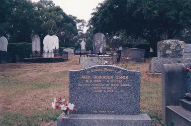
Photograph Album, Kodak, Phillip Island Cemetery, c 1990
The Album was compiled by Nancy McHaffie late 1990's, with the assistance of Edith Jeffery's, with her book "Garden of Memories" and extensive knowledge of Phillip Island. The Cemetery lies back from the road and is surrounded by Manna Gums, rare Peppermint Gums, Blackwoods and other native trees. In all 25 acres of land were set aside as Crown Land in the land settlement of 1868. There are 6.2 acres of wetlands near the cemetery entrance.Jack Robinson Oswin: Many of the trees now flourishing in the cemetery grounds were planted by Jack Oswin and his wife Coral. Born in Mildura in 1909, his association with Phillip Island started when he attended the Cowes Primary School during the war years. He was foundation member of the Phillip Island Conservation Society and played a key role in the purchases of the area of land known as Conservation Hill. In the early 1980s he was awarded the British Empire Medal in recognition for his services to conservation. Jack died on December 4th 1990, aged 81 years.phillip island cemetery, jack robinson oswin, coral oswin, nancy mchaffie, edith jeffery -
 Whitehorse Historical Society Inc.
Document, Jones Family History
Brief history of the Jones FamilyBrief history of the Jones Family from emigration of James Jones in 1852 to 1970 with papers relating to purchase and fencing of land, part of Crown Allotment 116G, Lot 2, for building of Nunawading South Primary School No 4808, including a native flora area, c 1957. Also papers from the Native Plants Preservation Society of Victoria.Brief history of the Jones Family jones, james, jones family, bette, walter edgar, lionel arthur, kones, k.e. & l.a., native plants preservation society of victoria, nunawading south primary school, no. 4808, mount pleasant road, nunawading, florists, lorikeet street, dagola court, koala avenue -
 Bendigo Military Museum
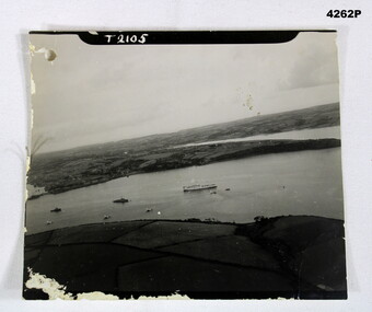
Photograph - AERIAL PHOTO, Possibly 1944
Photo in the collection of Reginald Charles Allardice No 418557 RAAF. Refer Cat No 3627.5 for his service details.B & W photo showing land and sea with one large ship and several smaller ones.On front, “T2105”. On rear in pencil,” Hospital ship Dorsetshire P.D 1 od.44 A/Z01”, stamped on rear “Crown copyright reserved”, above this as part of the stamp “A crown image M”photography, hospital ships -
 Bendigo Military Museum
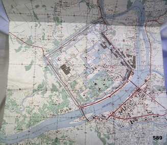
Map - MAP HUE VIETNAM, C.1960’s
The city of Hue is in South Vietnam. The map was used by a member of the AATTV during the Tet Offensive in Thau Thien province. Map brought home from Vietnam by Murray Stanley Metherall. Refer 590.2.Colour printed map of Hue Citadel on paper. Aerial view of land, river and building outlines.hue, vietnam, tet -
Federation University Historical Collection
Photograph, Opening of the Alcoa Laboratory, 1995, 08/12/1995
Four photographs from the opening of the Alcoa Laboratory for Soil and Land Management on the Mount Helen Campusalcoa laboratory, martin westbrooke, geoffrey colemen, john hannagan, alcoa laboratory for soil and land management -
 Phillip Island and District Historical Society Inc.
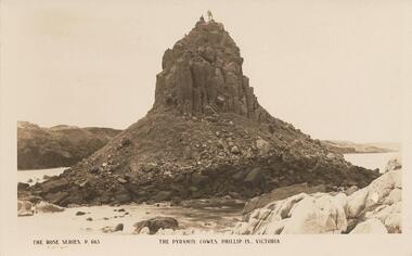
Photograph - Post Card, Early 1900's
Donated by G. HaywoodBlack & White Postcard of Pyramid Rock with two figures standing on top. Land mass in background."The Rose Series, P. 663" "The Pyramid, Cowes, Phillip Is., Victoria"pyramid rock phillip island, phillip island, g haywood -
 Montmorency–Eltham RSL Sub Branch
Artwork, other - Diorama, Cambodia, 2007
Chris Albers served in Cambodia, with the UN Forces late 90's Glass case rectangle, Land Rover UN markings, Figurines UN Military, plastic foliage.UN cambodia, un forces, -
 Phillip Island and District Historical Society Inc.
Photograph, 1978/79
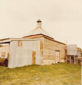
Chicory Kiln alongside the house of Mr T Woods in Settlement Road, East Cowes, was built in approx. 1870. It had 18" thick mud brick walls at the core.Photograph of Chicory Kiln on Settlement Road, East Cowes, on land owned by Mr. T. Woods.local history, photographs, buildings - historical, housing, rural industry, coloured photograph, john cook, phillip island, t woods -
 Eltham District Historical Society Inc
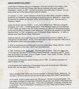
Folder, Josiah Morris Holloway, 1850s
Folder of information on Josiah Morris Holloway, land developer, 1850s. Founder of Little Eltham 1852.josiah morris holloway -
Poowong Historical Group
Land Title Amy Burchett and James Stroud Burchett
Land Title Amy Burchett and James Stroud Burchett 12 January 1903 4 pages2538/507545 LT L/H 3 Part of CA No. 7 Parish of Poowong -
Glenelg Shire Council Cultural Collection
Photograph - Photograph - Reclamation and Canal Work, 1959
Port of Portland Authority ArchivesBack: November 1959 top right, black biro. 23 1/2 top left pencil. 6c cnetre in pencil. Pencil border ruled around print.port of portland archives, reclamation, canal -
Glenelg Shire Council Cultural Collection
Photograph - Photograph - Main Breakwater construction, Portland, n.d
Port of Portland Authority Archivesport of portland archives, aerial photography, portland harbour -
 Ringwood and District Historical Society
Newspaper, Scrapbook Clipping, Library Collection, Ringwood, Victoria, `
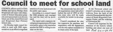
``Newspaper clipping from The Post , 24-11-93 P3 Council to meet for school landCouncil officers and Crs Chris McRae and Sylvia Phillips from Ringwood will meetwith the Direcvtorate of School Education property unit representatives to discuss future useof the closed Norwood and Ringwoo East School sites. The DSE property unit manager has said the sites will be developed.` -
 Bendigo Historical Society Inc.
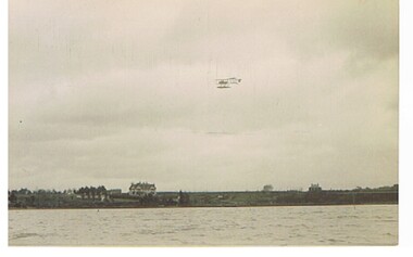
Postcard - BASIL WATSON COLLECTION: POSTCARD, BIPLANE FLYING OVER WATER
postcard: biplane flying over water, land in background, houses and trees. Location possibly in UK.aviation, civilian, biplane, basil watson collection, biplane -
Port Melbourne Historical & Preservation Society
Plan - Proposed land sub-division, west of railway, Sandridge, 19 Nov 1866
1866 plan of proposed sub-division of land at Sandridge, west of railway. Includes manure depot.J. Noone (Photolithographer, Dept. of Lands and Survey) J. Hardy (Assistant Surveyor)town planning, town planning - proposals shelved, j noone, j hardy -
 Port Melbourne Historical & Preservation Society
Photograph - Liardet Comminuty Centre, Port Melbourne, Glen Stuart, Jun 2003
The centre was expanded in 2003 to include six single, low cost apartments and some city officesColour photo of Liardet Community Centre (Temperance Hall) with land cleared for new extension in 2003built environment - civic, liardet community centre -
 Bendigo Historical Society Inc.
Photograph - HARRY BIGGS COLLECTION: JOHN WALLIS
Photograph (proof 58) of John Wallis (1831 - 1896). Lockwood land owner and Marong Councillorperson, individual, john wallios, john wallis, lockwood, marong councillor -
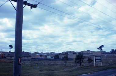 Robin Boyd Foundation
Slide, Robin Boyd, 1967
Colour slide in a mount. Princes Domain, land tract, possibly suburban Melbourne, Victoria, AustraliaMade in Australia / 8 / JUN 67M6 / Encircled 28a (Handwritten)slide, robin boyd -
University of Melbourne, Burnley Campus Archives
Article - Photocopy, Richmond - Site for Gardens, 1885, 1916
Copies of 3 articles re land reservation for Gardens at Burnley (1885) and road proclamation (1916)land reservation, burnley gardens, richmond -
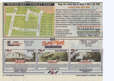 Whitehorse Historical Society Inc.
Article, Winton Rise, 21/02/1996 12:00:00 AM
Advertisement for land sale in Vermont SouthAdvertisement for land sale in Vermont South, also properties in Mitcham, Park Orchards and Ringwood for auction.Advertisement for land sale in Vermont Southelonara road, vermont south, valerie court, adrian avenue, justina close, scarborough road, stockdale & leggo, barry plant, nymph street, mitcham, barcelona street, box hill -
 Whitehorse Historical Society Inc.
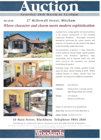
Document, Auction - 27 McDowall Street, Mitcham, 1/03/1998 12:00:00 AM
advertising auction of 27 McDowall StreetLand brochure advertising auction of 27 McDowall Street, Mitcham Saturday, 28th March, 1998. advertising auction of 27 McDowall Streetmcdowall street, mitcham no 27 -
 Whitehorse Historical Society Inc.
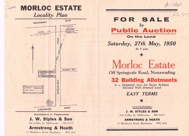
Document, Morloc Estate
Advertising brochure, including plan of landAdvertising brochure, including plan of land for sale in Morloc Estate, Nunawading off Springvale RoadAdvertising brochure, including plan of land morloc estate nunawading, land subdivision, springvale road, nunawading -
Whitehorse Historical Society Inc.
Document, James Clarendon Patrick Horneman, 2007
Documents about James Patrick Horneman, an early resident of Whitehorse, showing land purchases and certificates.Documents about James Patrick Horneman, an early resident of Whitehorse, showing land purchases and certificates.Documents about James Patrick Horneman, an early resident of Whitehorse, showing land purchases and certificates.horneman, james clarendon patrick -
Whitehorse Historical Society Inc.
Article, Too many industries, 1990
Article about subdivision of land of Wunderlich Monier, showing that this would increase the number of industries in the area.Article about subdivision of land of Wunderlich Monier, showing that this would increase the number of industries in the area.Article about subdivision of land of Wunderlich Monier, showing that this would increase the number of industries in the area.land subdivision, mitcham road vermont, rooks road vermont, wunderlich limited -
Whitehorse Historical Society Inc.
Document, Kaufmans Road, 1896
Documents and contracts about the sale of land bounded by Kaufmans, Canterbury and Bakers Roads Blackburn, 1896.Documents and contracts about the sale of land bounded by Kaufmans, Canterbury and Bakers Roads Blackburn, 1896.Documents and contracts about the sale of land bounded by Kaufmans, Canterbury and Bakers Roads Blackburn, 1896.canterbury road blackburn, bakers road blackburn, schwab, henri samuel, morton, thomas richards burrowes, land sales, kaufmans road blackburn -
Whitehorse Historical Society Inc.
Document, History of the South Vermont area
A short history of South vermont, from the land survey in 1855, including pioneers' names and occupations.A short history of South vermont, from the land survey in 1855, including pioneers' names and occupations.A short history of South vermont, from the land survey in 1855, including pioneers' names and occupations.vermont south, smith, l. l. dr., lobb, a, hoadley, mrs, confectionery, orchardists, norwich village, vermont, land subdivision -
Whitehorse Historical Society Inc.
Document, Edgerton Road Mitcham, 7/12/1973
Copy of letters to C. Schwerkolt re acquisition of land at Edgerton Road, Mitcham by Nunawading Councilland sales, city of nunawading, schwerkolt, charles clarence victor, edgerton road, mitcham -
Whitehorse Historical Society Inc.
Letter - Correspondence, Deep Creek Road, 20/08/1963
Copies of letters re acquisition of portion of the land by Nunawading Council in Deep Creek Road Mitchamland sales, jackschowsky, mary elizabeth, schwerkolt, charles clarence victor, city of nunawading -
 Whitehorse Historical Society Inc.
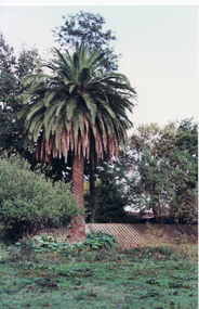
Photograph, Palm Tree - Schwerkolt Cottage, 21/04/2001 12:00:00 AM
Coloured photo of Palm Tree on original Schwerkolt Homestead land, abutting Schwerkolt Cottage Reserve.schwerkolt cottage, palm trees -
 Whitehorse Historical Society Inc.
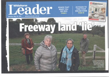
Article, Healesville Freeway Reserve Sell-off?, 2018
Chunks of land once earmarked for the now-cancelled Healesville Freeway could eventually be sold to developers.Chunks of land once earmarked for the now-cancelled Healesville Freeway could eventually be sold to developers.Chunks of land once earmarked for the now-cancelled Healesville Freeway could eventually be sold to developers.healesville freeway reservation, payne, ann, makhijani ann, friends of healesville freeway reserve