Showing 10632 items
matching maps
-
 Bendigo Historical Society Inc.
Map - KANGAROO FLAT SUBDIVISION, 26/11/1900
Map: Plan of Subdivision at Kangaroo flat, Parish of Sandhurst, County of Bendigo ( number 149 in Map Cupboard 1)map, bendigo, parish plan, kangaroo flat, parish of sandhurst, county of bendigo -
Bendigo Historical Society Inc.
Map - JANIEMBER EAST, 12/09/1876
Map: Two maps applied to the one backing, Township of Janiember East. Additional allotments, Townshihp of Janiember Eastmap, bendigo, janiember east, allotments janiember east, serpentine -
Bendigo Historical Society Inc.
Map - PLAN OF THE TOWNSHIP OF SANDHURST(PHOTOCOPY)
Map: Photocopy of a plan of the Township of Sandhurst. Dated 26 July 1854 ( number 141 in Map Cupboard 1)map, bendigo, city streets, township of sandhurst, early bendigo, city streets -
Bendigo Historical Society Inc.
Map - NERRING, 15/06/1937
Map: Parish of Nerring, County of Bendigo. Parish plan Canvas backed ( number 139 in Map Cupboard 1)map, bendigo, rural, nerring, county of bendigo -
Bendigo Historical Society Inc.
Map - YARRABERB, 17/12/1937
Map: Township of Yarraberb, Parish of Yarraberb, County of Bendigo. Parish plan (number 274 in map cupboard 1)map, bendigo, township, yarraberb -
Bendigo Historical Society Inc.
Map - NEWBRIDGE, August 17th 1875
Map: Township of Newbridge, Parish of Tarnagulla, County of Bendigo. Parish plan (number 272 in map cupboard 1)map, bendigo, township, newbridge -
Bendigo Historical Society Inc.
Map - AXEDALE, 12/07/1909
Map: Township of Axedale, Parish of Axedale, County of Bendigo. Parish plan (number 271 in map cupboard 1)map, bendigo, township, axedale -
Bendigo Historical Society Inc.
Map - RAYWOOD, 18/09/1930
Map: Township of Raywood, Parish of Neilborough,County of Bendigo. Parish plan (number 270 in map cupboard 1)map, bendigo, township, raywood -
Bendigo Historical Society Inc.
Map - GOORNONG, 1/10/1906
Map: Town of Goornong, Parish of Goornong, County of Bendigo. Parish plan (number 269 in map cupboard 1)map, bendigo, township, goornong -
Bendigo Historical Society Inc.
Map - RAVENSWOOD, April 6th 1872
Map: Township of Ravenswood. Parish plan, has a 1913 calendar as a backing (number 266 in map cupboard 1)map, bendigo, township, ravenswood -
Bendigo Historical Society Inc.
Map - PORTION OF SANDHURST, 27/01/1877
Map: Hand draughted parish plan, showing a portion of the City of Sandhurst ( number 225 in Map Cupboard 1)map, bendigo, parish plan, sandhurst -
Bendigo Historical Society Inc.
Map - SANDHURST (PART), Circa 1880's
Map: Parish plan sowing an area along Specimen Hill Rd. ( number 211 in Map Cupboard 1)map, bendigo, parish plan, specimen hill rd. sandhurst , bendigo -
Bendigo Historical Society Inc.
Map - EAGLEHAWK (PART), 22/01/1882
Map: Parish plan showing area Eastward from Lightning Hill ( number 205 in Map Cupboard 1)map, bendigo, parish plan, eaglehawk, lightning hill -
Bendigo Historical Society Inc.
Map - NERRING. SHEET ?, Circa 1894
Map: Nerring, Part ( number unreadable), County of Bendigo. Parish plan ( number 190 in Map Cupboard 1)map, bendigo, parish plan, nerring -
Bendigo Historical Society Inc.
Map - TARNAGULLA SHEET 1, Examined 25/08/1926
Map: Tarnagulla Sheet 1, Counties of Gladstone and Bendigo. Parish plan (number 304 in map cupboard 1)map, gladstone, parish plan, tarnagulla -
Bendigo Historical Society Inc.
Map - PARISH OF MARONG ALLOTMENTS, No date Visible
Map: Parish of Marong Allotments, County of Bendigo. Parish plan Blueprint (number 286 in map cupboard 1)map, bendigo, allotments, marong allotments -
Bendigo Historical Society Inc.
Map - FOSTERVILLE MAP, 19/08/1897
Map: Township of Fosterville, Parish of Ellesmere, County of Bendigo. Parish plan (number 277 in map cupboard 1)map, bendigo, township, fosterville, ellesmere -
Bendigo Historical Society Inc.
Map - NEILBOROUGH, 21/01/1875
Map: Parish of Neilborough, County of Bendigo. Hand Draughted Parish plan. Map dated 21/1/1875.map, bendigo, parish plan, neilborough -
Bendigo Historical Society Inc.
Map - CALAVIL, 28/08/1874
Map: Country Lands, Parish of Calavil, County of Bendigo. Parish plan (number 334 in map cupboard 1)map, bendigo, country lands, country lands, parish of calavil -
Bendigo Historical Society Inc.
Map - CITY OF BENDIGO STREET AND ROAD MAP, 1946
Map: City of Bendigo Street and road map, Incorporating the Borough of Eaglehawk and surrounding Districts. Compiled by W.C Harrymap, bendigo, city streets, bendigo streets -
Bendigo Historical Society Inc.
Map - CAMPBELL COLLECTION: BENDIGO AND DISTRICT MAPS
Map. Whirrakee, Parish of Whirrakee. Total area of map 4419 acres. Scale 20 chains to 1 inch. 23 allotments are sold, Eucalypt oil distillery on lower portion of map. Prepared in W.P.B. from Assessor's plan and Parish Plan. (number 350 in map cupboard 1)map, bendigo, allotments -
 Bendigo Military Museum
Souvenir - JACKET, Handmade in Vietnam, c1969
Item in a collection relating to Wes Bertuch, refer Cat No 1664.2 Jacket - bespoke handmade, in black cotton fabric exterior and white silk fabric lining. With collar, long sleeves, cuffs with black plastic buttons, inset pockets and elasticised area on waist band. Front zipper closure. Handstitched decoration on front, top of sleeves and back of jacket. Front - left side, yellow cotton? Vietnamese writing, Right side - yellow, orange, white and brown cotton - face of a tiger. Top of sleeves - left and right - orange and white cotton - dragons. Back of jacket - blue, orange, green and yellow map of Vietnam, Laos and Cambodia.On Jacket back - handstitched in yellow cotton "WHEN I DIE I'LL GO TO HEAVEN/ BECAUSE/ I'VE SPENT MY TIME IN HELL/ VIET & NAM/ 68 69". On and beside map - hand stitched in white cotton "LOVIS/ HANOI/ THAILAND HUE/ DA-NANG/ QLV-NI-ION/ BANGKOK NHA- TRANG/CAM-RANH/PHAN THIET/ BIEN HOA/ . On map - yellow cotton "CAMBODIA/SAIGON"souvenir, vietnam, clothing -
 Bendigo Military Museum
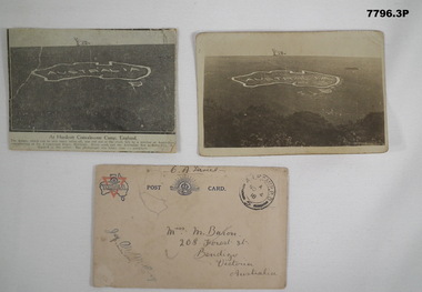
Postcard - POSTCARD - HURDCOTT, AIF CAMP, UK, R. H. Baron, 3. 3/11/1918
Cards relate to R.H. Baron's time at Hurdcott AIF Camp during 1918. Part of the "Robert H. Baron", No. 3596, and Cooper Collection. See Catalogue No. 1981P for details of Baron's service.1. Black and white newspaper clipping pasted onto a piece of cream card. Clipping features a black and white photograph of a map of Australia carved into the side of a hill. Caption in black type below photograph. 2. Black and white postcard style photograph of a map of Australia carved into the side of a hill. 3. Plain cream coloured postcard with YMCA logo and AIF insignia at the top. Handwritten address on front and handwritten letter on back.1. Handwritten in black ink on back: 'This map has been cut in the hill and is only about 10 minutes walk from here, Bob' 3. Handwritten in black ink on front: 'Miss M. Baron, 208 Forest St. Bendigo, Victoria, Australia'. Stamped in black on top R.H.C. of front: 'Postmark - AIF Camp P.O. No.4, 18,' Handwritten in black ink on back: 'Letter to R.H. Baron's sister Myrtle from Hurdcott Camp dated 3.11.18.'robert h. baron, cooper collection, postcards, hurdcott aif camp -
 The 5th/6th Battalion Royal Victoria Regiment Historical Collection
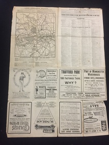
Map, Britain and Underground Railways, July 1919
Used by Australian Soldiers whilst on leave after WW1.Reversible map made of paper. One side has a map of Britain and Ireland printed in colour, the other has a map of the London underground as well as several advertisements. there are small tears along the fold lines.wark vc club, regiment property -
 Bendigo Historical Society Inc.
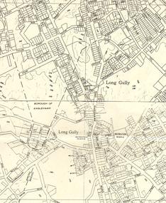
Map - LONG GULLY HISTORY GROUP COLLECTION: MAP OF LONG GULLY AREA
Map of Long Gully area printed on yellow paper. Map shows Eaglehawk Road from Don Street to Weatherall Street, then Mt Korong Road to Dowding Street. Some contour lines on the map.bendigo, history, long gully history group, the long gully history group - map of long gully area, borough of eaglehawk -
 City of Moorabbin Historical Society (Operating the Box Cottage Museum)
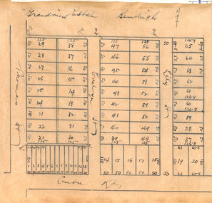
Plan - Grandview Estate
The train line from the city to Frankston was electrified in 1922 which intensified the sale in the municipality of Moorabbin, particularly land which was in the vicinity of the railway stations.The train line from the city to Frankston was electrified in 1922 which intensified the sale in the municipality of Moorabbin, particularly land which was in the vicinity of the railway stations. The Grandview Estate was auctioned on Saturday 10 November 1922.Example of the progress of the Municipality of MoorabbinHand drawn map of subdivision Grandview Estate, Bentleighcentre road, evelyn street (now wilson street), lily street, bentleigh, realestate, auction -
 Greensborough Historical Society
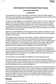
Article, Norm Colvin, Events leading up to the Plenty Ladies' Petition 1842, 2020_
This article, written and researched by Norm Colvin, GHS Secretary, identifies the people involved in the events leading to the petition to the Governor of Victoria, C. J. La Trobe, from 'Ladies resident on Plenty River' requesting protection from bushrangers, 5 May 1842. It identifies the bushrangers, the owners of the stations robbed, the group of men who rode out to assist and the identity of the "ladies" who signed the petition.This article identifies the people involved in the incidents, a list of locals in the 1840s.12 pages typescript, map.plenty river, bushrangers, petitions -
 Greensborough Historical Society
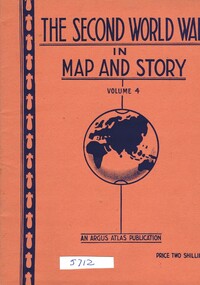
Book, Neville Smith, The Second World War in Map and Story, volume 4, ed. by Neville Smith, 1944_07
Series of articles published by the "Argus" 1941-1945, dealing with events and campaigns in World War 2.48 p., col. maps.world war 2 -
 Federation University Historical Collection
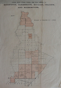
Plan, Lands held under leases for gold mining at Biddington, Carisbrook, Moolort, Craigie and Rodborough, not dated
Printed map with red shadingbiddington, carisbrook, moolort, craigie, rodborough, mining lease, d. fitzpatrick, m. mullins, d. fern, kong meng, p. mitchell, curtain and co, a. robertson, chalk's extedned, j. fay -
 Federation University Historical Collection
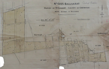
Map, No 6185 Ballaarat Parish of Ballaarat County of Grenville, not dated
Printed map with pencil inscriptionsmap, parish of ballaarat, grenville county, sebastopol, central company engine house, wesleyan reserve, victoria street, yarrowee street, charlotte st, kyle street