Showing 25615 items matching "plenty-township-estate"
-
 Merbein District Historical Society
Map, Township of Yelta, 30 Aug.1968
yelta -
Merbein District Historical Society
Map, Township of Yelta (Cowanna), 1958
yelta -
Merbein District Historical Society
Map, Township of Yelta, Jul.1968
yelta -
Merbein District Historical Society
Map, Township of Yelta, Jul.1968
yelta -
Merbein District Historical Society
Map, Township of Yelta (Cowanna), 1958
yelta -
Merbein District Historical Society
Map, Township of Yelta, 30 Aug.1968
yelta -
Merbein District Historical Society
Photograph, Merbein Township- Looking east towards Pumping Station, 1936
river avenue (taken from water tower), chaffey park tennis courts -
Merbein District Historical Society
Map, Township of Merbein - Sale of Allotments, 29 Jul.1914
-
Merbein District Historical Society
Photograph, Merbein township - looking along Main Ave, c.1950's
-
Merbein District Historical Society
Photograph, Merbein Township 2 - looking along Main Ave, c.1950's
-
 Linton and District Historical Society Inc
Photograph, Linton Township from Slaughterhouse Hill, circa 1920s, 1920
Slaughterhouse Hill was so named because Bennett's butchers had a slaughterhouse there.A view of Linton taken from Slaughterhouse Hill to the north-east of the town. Numerous buildings are identifiable in the photograph. In the middle foreground are the railway station, platform and station-master's house. The Grenville Standard building is visible in Clyde Street, and the Post Office and Bank of NSW buildings can be seen near the corner of Clyde and Sussex Streets. In the distance (along Sussex Street) the Royal Standard Hotel and the Shire Offices (original building) can be seen. St Paul's Church of England is on the far left of the photograph."Esther Cluff, Linton".linton township, slaughterhouse hill -
Lakes Entrance Historical Society
Book, Victorian Education Department, Ensay Township School State School No. 2953, 1889
Enrolment details of each student registered from 1889 to 1989. Includes parental detailsschools, occupation -
Linton and District Historical Society Inc
Certificate of Title, Certificate of Title : Crown Allotments 27, 28, 29, 30, Section 4, Township of Linton
The land was transferred to Theophilus William Nelson and James Adolphus Nelson in 1929. James and Theo Nelson later (1955) acquired Allotment 36, Section 4 which adjoins these allotmentsCopy of Certificate of Title for several adjacent blocks of land on the corner of Clyde Street and Grantley Street in Linton. Copy is comprised of photostat sheets held together by tape.theophilus william nelson, james adolphus nelson, certificates of title, allotments 27 - 30 township of linton -
Stawell Historical Society Inc
Map, Stawell Gold Mines, Stawell Township 1995, 1995
Map shows details of mining activity Stockpiles, Tracks, Plant, Dams,, Waste, Tailing Dams, IronbarksPlain Printed Map in Black & White with details of MiningStawell Gold Mines Pty Ltdmining -
Stawell Historical Society Inc
Map, Township of Stawell
B/W map of Stawell Surveyed by Easton Johnston Contract surveyor Scale in Chains. Showing Special Allotments Reefs, Pleasant Creek Parish of Stawell. Map No L4000 -
Stawell Historical Society Inc
Map, Plan View Township Area showing Known old workings 2003, 13 June 2003
Coloured Printing outline of lease of Gold Mine Horizontal Drives shown in BrownStawell Gold Mine. Scale 1:7500. Fri 13 June 2003mining -
Linton and District Historical Society Inc
Certificate of Title, Certificate of Title: Allotment 36, Section 4, Township of Linton
Title of the land was transferred to James Adolphus Nelson and Theophilus William Nelson in 1955. James and Theo Nelson had already purchased adjacent allotments 27 - 30 in 1929.Copy of a Certificate of Title for an allotment of land situated between Grantley Street and Springdallah Creek in Linton. Copy comprised of three photostat sheets held together by tape. Most recent holders of the Title recorded as James Adolphus Nelson and Theophilus William Nelson.certificates of title, allotment 36 section 4 township of linton, james adolphus nelson, theophilus william nelson -
 Ringwood and District Historical Society
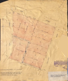
Document - Plan of Subdivision, Parts of Crown Allotments 45 & 46, Township & Parish of Ringwood, County of Mornington - 1950
Map on manila folder attached to cardboard backing showing residential allotments on King Street and Holland Road, Ringwood East.Signature of Russell Francis Kinnane, Licensed Surveyor, 4th December, 1950. -
 Ringwood and District Historical Society
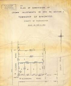
Map - Plan of Subdivision, Part of Crown Allotments 39 and 40 Section C, Township of Ringwood, County of Mornington - (Undated - circa 1930s)
Copy of land title map on light cardboard backing showing layout and size of 6 allotments in Illoura Road (later Illoura Avenue) and Alexandra Road, Ringwood East, Victoria. Rubber stamp imprint in top left corner - D.H. Oliver, Civil Engineer & Licensed Surveyor, Bellevue Street Lilydale, Phone Lilydale 91. -
 Ringwood and District Historical Society
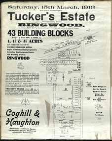
Card - Land Subdivision Clipping, Tucker's Estate, Ringwood, Vic. - 1913
Partially trimmed copy of a land subdivision auction advertisement on cardboard backing, with digitised copy of original flyer.Subdivision includes Thanet Street, Albert Street, Arlington Street, Barkly Street, Maidstone Street, Kirk Street, Vine Street, Surrey Street, Yarmouth Street and West Prussia Road (later Wantirna Road) Ringwood, Vic. Property names include Wandsworth, Ingleside, Lyndhurst and Karsruhe. Auctioneer and Estate Agents - Coghill & Haughton, 79 Swanston Street, Melbourne Auburn and Canterbury. Licensed Surveyor - W.P. Steane, M.C.E., 317 Collins Street, Melbourne. -
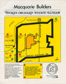 Eltham District Historical Society Inc
Document, Stokes Orchard Estate Eltham; Macquarie Builders, 1979c
Sales brochure including photocopy map of Stokes Place lots and Sales Manager's business card (John J. Herold). Stage 1 implemented c.1976 and Stage 2 c.1979. As shown on the plan, the lots along Diosma Road did not eventuate due to the lack of sewer system. These lots and streets were divided up into 5 acre blocks, which were not able to be subdivided till the 1990s when the sewer was run up Diosma Road. Stokes Place was part of the Stokes Orchard Estate which was developed from the break-up of the the orchard owned by Frank Stokes who lived on the northeast corner of Nyora Road and Eucalyptus Road. His daughter Beryl advised that the Shire had levied a rate assessment on individual parcels of land within the orchard which became unaffordable resulting in its sub-division and sell off. The Stokes Orchard Estate was developed by Macquarie Builders in two stages starting with stage 1 in 1976. Stokes Place was part of Stage 2 in 1979. The Estate was bounded between Nyora Road, Eucalyptus Road, Diosma Road and Stokes Place. The original orchard only just reached the left most portions of Stokes Place and did not go fully up to Diosma, rather to just beyond the extant of Stokes Place. Stokes Place was known within the family as "The Oats" as that is where they grew oats. Frank Stokes moved to Eltham c.1945 after visiting Harold Bird to view his orchard, located diagonally opposite Stokes Orchard from the intersection of Eucalyptus Road, Pitt Street and Nyora Road. It was on Harold Bird's recommendation that Frank purchased the land.The Stokes Orchard Estate collection is typical of housing developments of the late 1970s and 1980s. It was one of the earliest estates in Eltham following the nearby Woodridge Estate development.A4 colour brochure double sided, A4 photocopy and business cardAs notedstokes place, eltham, stokes orchard, stokes orchard estate, streets, houses, peter and carla vermey -
 Greensborough Historical Society
Mixed media - Folder containing photographs and disc, Family photos of Chapman and Stock families, 1860o
A collection of photos of the Chapman and Stock families of Greensborough and Lower Plenty.Photos and letters have been digitised by Peter Blackbourn as part of his family history research.Compact Disc. Contains 95 images of Chapman, Stock, Blackbourn and Barnett families dating from late 19th century through the 20th century. Also printed copies of photographs.Greensborough and Lower Plenty photos from Chapman and Stock familiespeter blackbourn, chapman family, stock family lower plenty, chapman stock family -
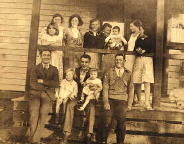
 Eltham District Historical Society Inc
Photograph, Daughter of the owner, Miss Irene Browne, sitting on the verandah of the Lower Plenty Hotel, c.1940-c.1943
Sidney and Ivy-Jane Browne purchased the Lower Plenty ‘Golf Club’ Hotel in 1940. They owned it until 1943. Their daughter, Irene Stella, was born in Eltham in July 1923 and would have been between 17 and 20 years of age at the time this photograph was taken. Ivy-Jane (nee Williams) was born in Eltham in December 1899 and was the sister of George Alfred Williams who is commemorated on the WWI plaque at the back of St. Margaret’s church, Eltham, and whose name is also listed on the Cenotaph in front of the Eltham War Memorial in Main Road, Eltham. Irene Browne married Leslie Allan Walker in 1945 and following his death in 1958 she married Charles William Smith. She died in 2008 and is buried in Omeo Cemetery along with her husband, Charles Smith. Her granddaughter, Veronica Gunn, advises a few years earlier, Irene’s son took her to the hotel and spoke with the then owner who showed Irene the photo, which she confirmed was of herself. Digital filelower plenty, lower plenty hotel, hotels, irene stella browne, irene stella smith, golf club hotel, 1940s -
 Kiewa Valley Historical Society
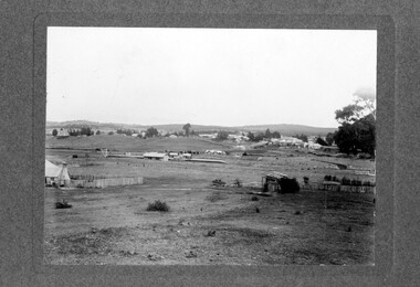
Photo - Bogong Township, September 1953
In 1940 Field Headquarters for the Kiewa Scheme were established at Bogong with office, workshop facilities and accommodation for workmen, staff and some families constructed. (There had been a 'tent camp' on this site in 1939 but was destroyed by bushfires) Construction of accommodation continued until 1947. A total of 40 houses plus a hostel for single staff, post office, police station, medical centre and primary school all with water and sewerage and electricity supply. The staff hostel was known as Kiewa House and is now occupied by the Education Department. Lake Guy was named after Mr. L.T. Guy who was the Resident Engineer in charge of construction work and associated activities on the Kiewa area. He held this position from 1939 to November 1946 when he was transferred to Head Office. The Bogong Township was developed firstly as an accommodation centre (base camp) for construction workers employed under the Kiewa Hydroelectric Scheme. Due to the influx of European workers into the Township the beautification of the immediate surrounds (gardens etc.) had a distinct European flavour. This environment has been very beneficial for tourism in later years. At the completion of the scheme, in the 1960's, the village was opened to public/tourism use. Strict environmental control has not allowed for any extensive redevelopment in tourist accommodation and basically restricted it to the accommodation initially built for the construction workers. Activities such a bike riding, snow skiing, restricted horse riding and bush walking on the Alpine plains and mountains are now a viable part of the Kiewa Valley Tourist Industry. The lake is one of the many water storage reservoirs used to supply the power stations their main power to run the huge turbines generating the final product, electricityBlack and white photograph of Bogong Township taken from Little Arthur fire track. September 1953Faded handwritten inscription on back - Bogong Township taken from Little Arthur fire track. Sept 1953bogong village, secv -
 Ringwood and District Historical Society
Pamphlet, G.A. Green, Auction Sale Brochure - Garden Farms Estate, Ringwood, Victoria - 1919, 1919
Multi-fold brochure advertising public auction of one-acre, 2-acre, 5-acre and 8-acre allotments in Ringwood and Bayswater on Saturday 12th April, 1919. Brochure includes terms of sale, description of subdivision features and local facilities, and photographic images of the area.Subdivison includes Canterbury Road Heathmont, Armstrong Road Heathmont, Armstrong Road Bayswater, Bungalook Road Heathmont, Bungalook Road Bayswater, and Orchard Road Bayswater. Road shown as Bayswater Road to Bayswater became Mountain Highway Bayswater. Vendor: H.E.B.Armstrong, Auctioneers: Coghill & Haughton, 79 Swanston Street Melbourne, Telephone Central 2793, in conjunction with J.B. McAlpin, Ringwood, Opposite Station, Telephone Ringwood 7. (Map) Woodcock & McCormack, Civil Engineers Architects & Surveyors, 430 Little Collins Street, Melbourne, Phone 3241 Central. MOST OF THE MONEY COMES OUT OF THE LAND. And more money can be obtained from anb acre of fruit than from an acre of any other produce. But you do not have to grow fruit on Garden Farms Estate. You can go in for - Outer Suburban Home - Market Garden - Orchard - Pig Raising - Poultry Farm - Small Dairy Farm - Small Fruits - Floral Culture - Scent and Bee Farm - Or just for a Week-end Home. RINGWOOD - THE PLACE TO LIVE. The Beautiful Ringwood District has so many natural attractions, that half a Land Agent's work is done in just showing a prospective buyer round and about. Ringwood has a pull of its own that attracts folk, proved beyond doubt by its rapid development within the last decade (spite the war). First, it is high and healthy, picturesque and undulating, convenient of access, sufficiently close to the Metropolis for City and Business folk to live at Ringwood. Its development is solid, because most of its people are industrious husbandmen, real producers, who have turned idle hills into smiling gardens. These are the kind of real people to live amongst; ones who wear out their spades. The rapidly-developing town has excellent Stores, Trade and Repair Shops Churches, Banks, Telephone Exchange, Weekly General Market, Cool Stores, and good Private and State Schools, etc.; is Electrically lit, has Metropolitan Water Supply, and generally provides so that practically all shopping can be done locally. WHY RINGWOOD MUST GROW. Ringwood is a great centre and must be a greater. Two rapidly-developing railways junction here. The passengers from Ringwood Station cityward, in one year, number 250,000. Ringwood will be the terminus of the Outer Suburban Electric Eastern Railway. Its natural boundaries are the River Yarra on the North, Dandenong Creek on the South, the popular town of Croydon on the East, and the suburb of Mitcham on the West. This is a large territory that is steadily being converted from intense culture, and then it might be called (as regards its gardens) "The Devon Territory of Victoria." ARMSTRONG ROAD. This new road traverses Garden Farms Estate from its northern boundary on the main Canterbury Road, across Dandenong Creek, to its southern boundary on the main Bayswater Road, and will provide a long-desired additional link of communication between Bayswater and Ringwood. The 1-acre building sites on Bayswater Road are within 8 minutes' walk of the Bayswater Railway Station, and the Canterbury Road frontages are only 1-1/2 miles from Ringwood Station, and 1/2 mile from the Railway Station site of Canterbury Road; therefore, the whole Estate is easy of access and there should be a large demand for land so favourably placed. (Image) Cultivation Field - Potatoes on Lot 28 (Image) Picture of Bayswater Creek Flats. (Image) View from "Korumbeen" where Mr. Armstrong lived on Garden Farms Estate. Estate outlined in white ring. (Image) Site of New Bridge over Dandenong Creek. (Image) On one of the timbered lots adjoining railway. (Image) This Dandenong Creek traveres the Estate. (Image) Main Fern Tree Gully Line bisects the Estate. -
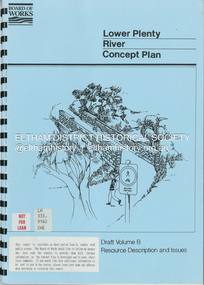 Eltham District Historical Society Inc
Book, Brett Cheatley et al, Lower Plenty River Concept Plan; Maroondah Pipetrack - Greensborough to Yarra/Plenty Confluence; Draft Volume B, Resource Description and Issues, February 1991
concept plan, melbourne metropolitan board of works, plenty river, report -
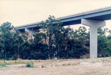
 Eltham District Historical Society Inc
Photograph, Bridge construction over the Plenty River at Plenty River Drive; Greensborough Bypass construction, c.1986, 1986c
Shows the eastern bridge of the Greensborough Bypass under construction. Colour photograph originally located in a magnetic style album titled 'Greensborough Bypass 1990s 5' suffering significant degradation. No information contained in album or on reverse of photos except where noted. Relocated to archival photosafe storage.greensborough bypass, road construction, plenty river drive, greensborough, bridge construction -
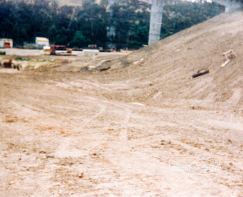
 Eltham District Historical Society Inc
Photograph, Looking west across the new 5-span bridge construction across the Plenty River from near Plenty River Drive; Greensborough Bypass construction, c.1986, 1986c
Colour photograph originally located in a magnetic style album titled 'Greensborough Bypass 1990s 5' suffering significant degradation. No information contained in album or on reverse of photos except where noted. Relocated to archival photosafe storage.greensborough bypass, road construction, greensborough, plenty river drive, bridge construction -
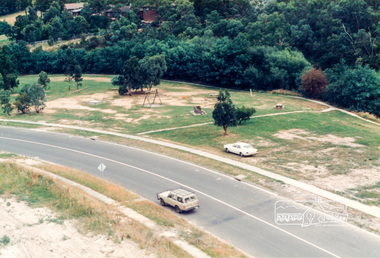 Eltham District Historical Society Inc
Photograph, Looking south onto the Plenty River Trail Reserve from the new bridge ove the Plenty River; Greensborough Bypass construction, c.1986, 1986c
Colour photograph originally located in a magnetic style album titled 'Greensborough Bypass 1990s 5' suffering significant degradation. No information contained in album or on reverse of photos except where noted. Relocated to archival photosafe storage.greensborough bypass, road construction, greensborough, plenty river drive, plenty river trail -
 Eltham District Historical Society Inc
Photograph, Looking south onto the Plenty River Trail Reserve from the new bridge ove the Plenty River; Greensborough Bypass construction, c.1986, 1986c
Colour photograph originally located in a magnetic style album titled 'Greensborough Bypass 1990s 5' suffering significant degradation. No information contained in album or on reverse of photos except where noted. Relocated to archival photosafe storage.greensborough bypass, road construction, greensborough, greensborough plaza