Showing 1846 items matching "rivers in victoria"
-
 Lakes Entrance Historical Society
Photograph - P.S. Tanjil, Vogt. W S, 1915 c
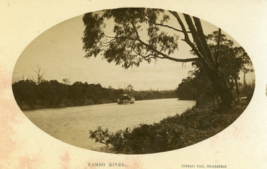
Black and white photograph showing P S Tanjil on Tambo River. Water level high in river, note bushes in water. Eucalypt hanging over the river on right. Thick vegetation on banks. Swan Reach VictoriaTambo Riverships and shipping, waterways -
 Lakes Entrance Historical Society
Photograph - S.S. Bellbird, 1906 c
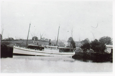
Bellbird built by George Fraser 1905, went to NZ with Fraser familyBlack and white photograph showing S S Bellbird at Johnsonville on Tambo River, shows wharf and shed on right hand side, few dead trees on hill in background. Johnsonville Victoriaboats and boating, waterways -
 Lakes Entrance Historical Society
Photograph - Mossiface Wharf, 1908
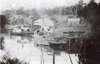
Black and white photograph showing P S Tanjil left and S S Burrabogie right at Mossiface Wharf on the Tambo river. Larger open sided white shed at wharf, smaller shed further back, pipes on wharf small row boat beside stern of Burrabogie. Hillside partly cleared trees ring barked. East Gippsland Victoriaships and shipping, waterways, wharfs -
 Lakes Entrance Historical Society
Photograph - Paynesville Slipway, 1910 c
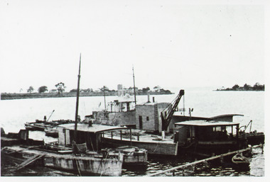
Photocopy of photograph has names of all the boats, W H Edgar, suction dredge called Paynesville, grab dredge called Priest Man, stores barge called Lady Harriet, a boat used to keep rivers free of snags called Snagger, sand hopper barge from W H Edgar in process of being dismantled. Information provided by Reg Schulz.Black and white photograph showing five boats / barges at slipway, one with crane. Little row boat in foreground at jetty. Point of land in background, Raymond Island, sparse vegetation. Paynesville Victoriaships and shipping, wharfs -
 Lakes Entrance Historical Society
Photograph, Reg Schulz, 1938
Black and white photograph of shipping at Bairnsdale wharf, Mitchell River. Vessels unidentified, passenger vessel tied up, small shed on wharf. Bairnsdale Victoria jetties, ships and shipping -
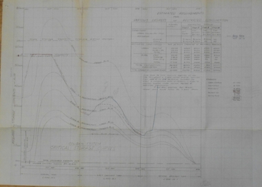 Bendigo Historical Society Inc.
Document - STATE RIVERS AND WATER SUPPLY COMMISSION : COLIBAN SYSTEM CRITICAL STORAGE CURVES
State Rivers and Water Supply Commission of Victoria. Coliban System. Construction of Lake Eppalock. Chart titled 'Coliban System Critical Storage Curves'. Includes table headed ' Estimated requirements for various degrees of restricted consumption' related to the demand on the Coliban River. Figures on storages of Upper Coliban, Lauriston, Malmsbury, Barkers Creek, and Spring Gully. There are penciled notations added. The information appears to be for the years 1957/58/59. state infrastructure, water supply, coliban system, state rivers and water supply commission of victoria. coliban system. lake eppalock. -
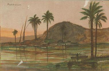 Bendigo Historical Society Inc.
Postcard - BLANCHE SLY POSTCARD COLLECTION, 1900 - 1920
Postcard Album of Blanche Sly. Postcards stored in Folder 81 (49 postcards). 1403.1 - 1403.28 Grey linen look cover with picture of a small sailing boat pasted centre front pf cover. Partly torn sticker on lower LH corner. Blanche Victoria SLY Born: 11 Oct 1890, daughter of William and Hannah Sly Address: 1913; Loddon Vale Address: 1980; 100 Barnard Street Bendigo Died: Bendigo 12 June 1982, buried Bendigo G3 William Sly: Born: 1856 at Smythesdale, Victoria Married in Victoria in 1887; Hannah Theilman Died: Bendigo 1937, buried Bendigo G1 Hannah Sly Nee Theilman Born: 1866 Married in Victoria in 1887; William Sly Died: Bendigo 1948, buried Bendigo G3 See additional Research .Postcard Album of Blanche Sly containing 49 postcards. See 1403 Coloured painting of a landscape with palm trees, river, man in a boat and buildings on far bank. Mokkatam, Egypt Artist - A Vivenzio? . Addressee - Mrs. W Sly, Loddon Vale, via Pyramid, Victoria Sender - Pte S Olgaiti Not datedpostcard, collector, blanche sly -
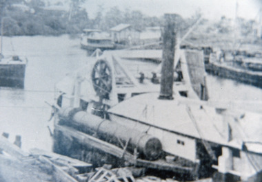
 Lakes Entrance Historical Society
Photograph - Dredging, Lakes Post Newspaper, 1994
Also in the album is a copy of a newspaper article from the Lakes Post Wednesday July 27 1994 featuring Bernie Grant who spent 17 years working to keep at bay the shifting sands of the channels of the lakes and rivers of the Gippsland LakesBlack and white photograph of suction pump from the dredge Paynesville at Eastern wharf, Lakes Entrance, Victoria.dredging, jetties -
 Eltham District Historical Society Inc
Photograph - Digital Photograph, Alan King, Downing-Le Gallienne house, Yarra Braes Road, Eltham, 30 January 2008
The property is a classic example of what made Eltham famous from the late 1940s to the 1960s. Covered under Heritage Overlay, Nillumbik Planning Scheme. Published: Nillumbik Now and Then / Marguerite Marshall 2008; photographs Alan King with Marguerite Marshall.; p149 The first view of the large double-storey house at Yarra Braes Road, Eltham South, is of a jutting roofline over a balcony, reminiscent of a large sailing vessel or galleon – very appropriate, considering the name of one of the first owners, Le Gallienne. The Downing-Le Gallienne property is a classic example of what made Eltham famous from the late 1940s to the 1960s and attracted so many artists and intellectuals to the area. Set in a largely indigenous bush-style garden, the mud-brick and timber house was built by Alistair Knox. It was built for economist Richard Downing, to become a founder of the welfare state in Australia and Chairman of the Australian Broadcasting Commission, and musician and composer Dorian Le Gallienne. Le Gallienne was a pioneering composer of modern music in Victoria before 1945, whose works included the Symphony in E.1 He wrote several pieces of film music for Eltham Films, including The Prize, working with its writer and artistic director Tim Burstall. Le Gallienne was also a music critic for The Argus and later for The Age. In 1967 the music critic Roger Covell argued that Le Gallienne’s Symphony, was ‘still the most accomplished and purposive . . . written by an Australian’. According to Alan Marshall the main inspiration behind the building that evolved from 1948 to 1964 was Le Gallienne. ‘He was able to see value in the simplest things and many who worked there had their eyes opened for the first time to the Eltham environment, to the bush and the trees and the fauna which lived there.’ The garden included no formality, no lawns, nor exotic plants. ‘Natural informal growth came right up to their doors and so did the indigenous birdlife.’ This informal style – consisting of mass and void – was to be developed and popularised by landscaper Gordon Ford from the 1950s. The large mud-brick and timber house, which was built in four stages and has three separate but linked sections, began as a small weekend retreat for the couple. In 1948, Downing and Le Gallienne (Dick and Dor to their friends), asked Knox to build the 36 x18 foot (11mx5.4m) building with a pitched slate roof. It was built on a concrete slab and included a fireplace, which is still in use. The second wing was built in 1954 after Downing had returned from working at the International Labour Office and the couple decided to live there full-time. The third section was built after the death of Le Gallienne in 1963, aged 48. He is buried in the Eltham Cemetery. When Downing married widow, Jean Norman (nee McGregor) and had to accommodate a large family, including her six children and one of their own, the last stage was built by 1964. At that time the house was considered one of the largest mud-brick houses in Victoria. It consists of five living areas, including a small ballroom. Several artists helped Knox build the Downing-Le Gallienne house, which was one of his first of mud-brick. They included painter Clifton Pugh, artist John Howley and actor Wynn Roberts. Ellis Stones had landscaped the first wing and Gordon Ford set the boulder steps and made a pool as part of the landscaping he completed. Inside, the mud-bricks are largely whitewashed with pine-lined ceilings and Oregon beams. A winding timber staircase in the front extends behind a glass window from the ground floor to the top. The property, of a little more than 0.5 ha, is bordered by Parks Victoria land, which extends to the Yarra River.This collection of almost 130 photos about places and people within the Shire of Nillumbik, an urban and rural municipality in Melbourne's north, contributes to an understanding of the history of the Shire. Published in 2008 immediately prior to the Black Saturday bushfires of February 7, 2009, it documents sites that were impacted, and in some cases destroyed by the fires. It includes photographs taken especially for the publication, creating a unique time capsule representing the Shire in the early 21st century. It remains the most recent comprehenesive publication devoted to the Shire's history connecting local residents to the past. nillumbik now and then (marshall-king) collection, dorian le gallienne, downing-le gallienne house, eltham, mudbrick construction, mudbrick houses, richard downing, yarra braes road -
 Lakes Entrance Historical Society
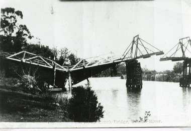
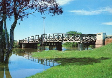
Photograph - Bridges, Bulmer H D, 1925
Swan Reach Bridge collapsed 10.00 am 16 November 1925Black and white photograph showing collapsed bridge over the Tambo River, bridge collapsed at eastern end. Photo looking downstream. Two people on landing on far right bank behind right hand bridge pylon. Thick vegetation on bank. Swan Reach VictoriaSwan Reach Bridge on the Tambo Riverwaterways, boats and boating, disasters -
 Lakes Entrance Historical Society
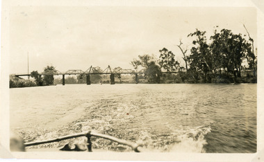
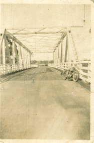
Photograph - Bridges, 1925
Photo taken same year Swan Reach bridge collapsed 16 November 1925Black and white photograph of the lifting bridge over the Tambo River taken from the stern of a boat. A tourist launch under the bridge in distance. Swan Reach Victoriabridges, waterways -
 Lakes Entrance Historical Society
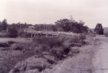
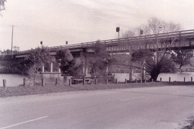
Photograph - Bridges, Fish Marie, 1995
Black and white photograph showing view of the Swan Reach bridge over the Tambo River. Traffic lights on bridge to control traffic and reduce weight. Swan Reach Victoriabridges, waterways, roads and streets -
 Lakes Entrance Historical Society
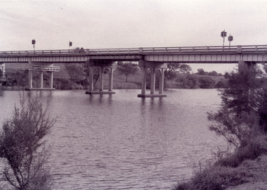
Photograph - Bridges, Fish Marie, 1995
Black and white photograph showing view of the Swan Reach bridge over the Tambo River. Traffic lights on bridge to control traffic and reduce weight. Swan Reach Victoriabridges, waterways, roads and streets -
 Lakes Entrance Historical Society
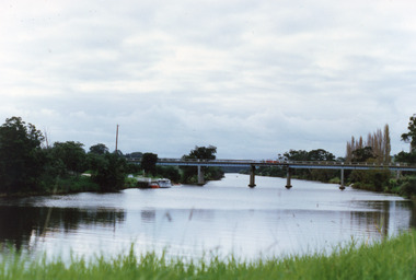
Photograph - Bridges, Fish Marie, 1995
Black and white photograph showing view of the Swan Reach bridge over the Tambo River. Traffic lights on bridge to control traffic and reduce weight. Swan Reach Victoriabridges, waterways -
 Lakes Entrance Historical Society
Photograph - Bridges, Fish Marie, 1995
Black and white photograph showing view of the Swan Reach bridge over the Tambo River. Traffic lights on bridge to control traffic and reduce weight. Swan Reach Victoriabridges, waterways -
 Lakes Entrance Historical Society
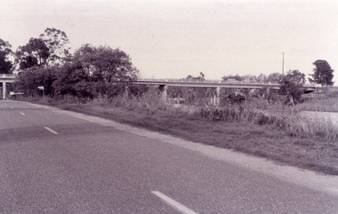
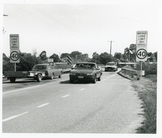
Photograph, 1994
Date made March 1994Black and white photograph showing traffic and restriction signs on Swan Reach Bridge, over theTambo River prior to funding being made available for strengthening and widening. Swan Reach Victoriabridges, waterways, vehicles -
 Lakes Entrance Historical Society
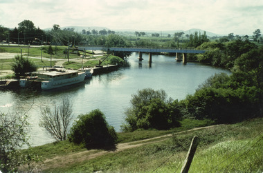
Photograph - Bridges, 1990
Colour photograph showing view of the Tambo River at Swan Reach looking upstream. Boats at jetty on left, vegetation on each bank, poplar trees on right. Swan Reach Victoriabridges, waterways -
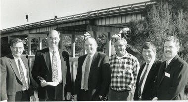 Lakes Entrance Historical Society
Photograph - Bridges, 1994
Image appeared in Lakes Post newspaper 18 May 1994Black and white photograph of six men standing beside the Tambo River, with the Swan Reach bridge in the background, meeting to stress the poor condition of the bridge and the urgent need for the promised funding. Swan Reach Victoriabridges, waterways, public events -
 Lakes Entrance Historical Society
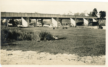
Photograph - Bridges, 1940
After 1934 flood damage to second bridge, centre pile was replaced by a truss girder, this survived until 1971 floodBlack and white photograph showing second Orbost Bridge over the Snowy River, wooden planks, railing and overhead support. Motor bike leaning on railing at near end of bridge. Orbost, Victoria.bridges, waterways -
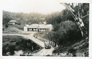 Lakes Entrance Historical Society
Postcard - Blue Duck Hotel, 1940
... Wills Rd, East Gippsland, Victoria. Bridge over Mitta Mitta..., East Gippsland, Victoria. Bridge over Mitta Mitta River, house ...Hotel buildings moved from Omeo to present site, 1928 by William O'ConnellBlack and white postcard showing Blue Duck Hotel, Glen Wills Rd, East Gippsland, Victoria. Bridge over Mitta Mitta River, house at back, sedan car leaving bridge, dense forest surrounding.Blue Duck Hotel Glen Wills Roadbridges, hotels -
 Lakes Entrance Historical Society
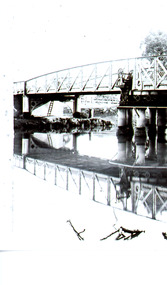
Photograph - Bridges, 1935
Also second photograph of swing bridge closed with lady in the foreground 6 x 8.5Black and white photograph showing closed swing bridge over Latrobe River, corner of jetty lower right hand corner. Sale, Victoria.bridges, waterways, jetties -
 Lakes Entrance Historical Society
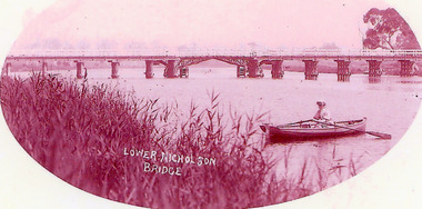
Photograph - Bridges, 1900
Opened March 1889, centre lifting span unsuccessful so shipping trade up Nicholson River effectivly terminatedPink toned scanned photograph of the first bridge across the Nicholson River. Shows a timber bridge with centre designed as a drawbridge. Woman in rowing boat in foreground. Nicholson VictoriaNicholson River Bridgebridges, waterways -
 Lakes Entrance Historical Society
Photograph - Bridges, 1925
Black and white photograph showing rail bridge across Mitchell River. Photograph shows side of rail bridge on south side, trees top right hand corner. Left hand side of photograph shows the road bridge. Bairnsdale, Victoriabridges, waterways -
 Lakes Entrance Historical Society
Photograph - Bridges, 1950
Colour photograph of unfinished Cataraman Llinase on Mitchell River, at Bairnsdale Wharf, railway bridge and highway bridge over the river, road to Paynesville under bridge, wharf on left, Mt Taylor and Mt Lookout in background. Bairnsdale Victoriabridges, waterways, boats and boating -
 Lakes Entrance Historical Society
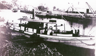
Photograph - Waratah, 1900 c
Ref Maritime Guide on the Gippsland Lakes P18 by J.A Derbyshire BairnsdaleEnlarged black and white photograph showing small steamer Waratah on Mitchell River at Bairnsdale Wharf, S S Gippsland far left, old butter factory far right. Bairnsdale Victoriaships and shipping, jetties, waterways -
 Lakes Entrance Historical Society
Photograph - MV Maranui, 1930 c
Black and white photograph showing Broomes launch Maranui in Tambo River (?) Thick vegetation on either bank. Several people on boat, one man centre lower edge on the bank watching. Swan Reach VictoriaBroome's Launch (written on back)waterways, boats and boating, tourism -
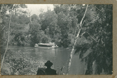
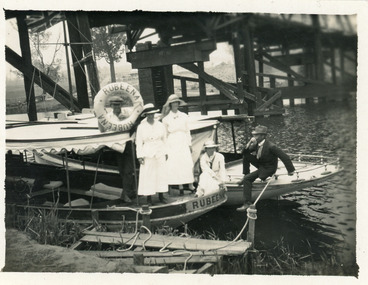 Lakes Entrance Historical Society
Photograph - Rubeena, 1923 c
Black and white photograph showing two tourist ferries, MV Rubeena and possibly MV Loch Ard, tied up below the old Swan Reach bridge on the Tambo River. Shows three ladies on the Rubeena, and one man on the Loch Ard. The Union Jack flag flying on the Loch Ard. Swan Reach Victoriawaterways, boats and boating, tourism -
 Bendigo Historical Society Inc.
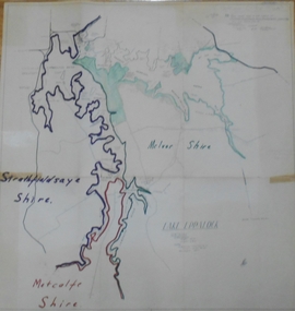
Map - STATE RIVERS AND WATER SUPPLY COMMISSION : LAKE EPPALOCK
State Rivers and Water Supply Commission of Victoria. Coliban System. Lake Eppalock. Map of Lake Eppalock foreshore area. Colour is used to delineate the areas of the Lake included in the three councils - McIvor Shire, Metcalf Shire and Strathfieldsaye Shire. Scale is 1 inch = 40 chains. Various notations in pencil have been added, with 'Coliban Office Plan' written and circled in the top right corner. A coloured (green) area is scaled as 'fore shore area in the charge of Derrinal Recreational Area Management Committee'. Individual leasing details have been added. state infrastructure, water supply, coliban system, state rivers and water supply commission of victoria. coliban system. lake eppalock. -
 Lakes Entrance Historical Society
Photograph - Bridges, Murray Views Gympie, 1980
Photo printed on Jumbo card by Murray Views, Gympie QLDColour photograph showing swing bridge on Latrobe River, shows north facing side of bridge, willows on opposite bank on site of Latrobe River wharf, river running very high, two red gum trees in water on left. Longford Victoriabridges, waterways -
 Bendigo Historical Society Inc.
Postcard - Alice McGregor Postcard Collection, 1900 - 1920
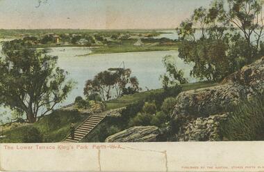
Alice McGREGOR Born: 1908; unknown parents. Possibly adopted by the Salter family? Electoral Roll 1936: Highland Terrace Kangaroo Flat. Alice Mary Salter and William Robert Salter living together; presumed to be sister and brother. William Robert Salter was killed in a MVA in Bendigo in 1937 aged 26. In Victoria in 1938, Alice Mary Salter married James Thomas McGregor (born Victoria 1917, died Victoria 1983, buried Fawkner Cemetery) Lived: 1968; 22 Wade Street Golden Square Alice McGregor Died: 1999 aged 91 at Anne Caudle Centre, Bendigo Buried: Kangaroo Flat Cemetery See additional research. Postcard Album of Alice McGregor contained 86 post cards.Postcard Album of Alice McGregor containing 86 post cards. See 1400. Colour photo of The Lower Terrace, King's Park, Perth. W.A. Swan river in middle ground, man standing at bottom of steps. Early years of Perth in background Addressed to Miss A. Stapleton, Arcade, Bendigo, Victoria Sender not given Undated postcard, collector, alice mcgregor