Showing 1792 items matching "settlement."
-
 Phillip Island Golf Club
Photograph - Ladies Matchplay
-
 Phillip Island Golf Club
Photograph - Ladies Foursomes
-
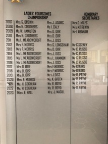
 Phillip Island Golf Club
Photograph - Honorary Secretary
-
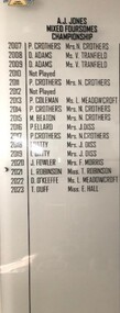 Phillip Island Golf Club
Photograph - A J Jones Mixed Foursomes
-
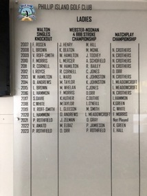 Phillip Island Golf Club
Photograph - Walton Ladies Singles
-
 Phillip Island Golf Club
Photograph - Webster & Noonan 4BBB Stroke
-
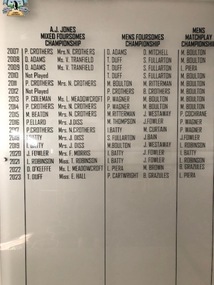 Phillip Island Golf Club
Photograph - Men's Foursomes Championship
-
 Sunbury Family History and Heritage Society Inc.
Photograph, The Nook
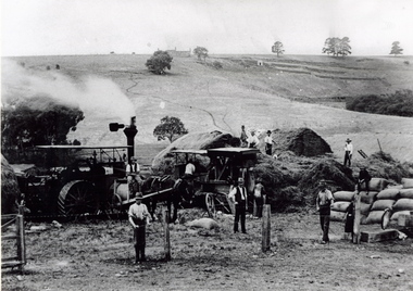
The photograph was taken in The Nook. Terence O'Brien rented the land from Goonawarra from the 1890s to 1905 where he grew cereal crops. The terraces on the hillside were built to grow vines when the property was one of the first vineyards in the area. The men in the image are from L-R: Mr. Heath in the white cutter owned the chaff cutter, John Leyden with hand on fence, Michael Dillon, Terence O'Brien and Phil Ratile are on top of the haystack, Andy Burke standing with hand on hip.The growing and harvesting of cereal crops was an important agricultural industry in the early days of Sunbury's settlement by both the Indigenous People and Europeans.A non-digital photograph black and white photograph of eleven men gathering hay with the aid of a steam traction engine in a wide open valley. A hillside in the distance has been terraced and there is a house on the hill in the distance.the nook, terence o'brien, andy burke, mr. heath, michael dillon, philratile, goonawarra, vineyards -
 Whitehorse Historical Society Inc.
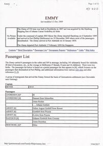
Document - Passenger List, http://graememoad.com/Family/Ships/emmy.htm, Emmi (also Emmy) Passenger Ship List, 1849, 12/12/2009
Passenger list for the 1849 voyage of the Emmy which departed Hamburg on 6 September and arrived in Port Phillip on 19 December.The passenger list is for the 1849 voyage of the Emmi (anglised to Emmy) which departed Hamburg on 6 September 1849 and arrived in Post Phillip on 19 December 1849. The immigrants included August Schwerkolt who later settled in Mitcham.non-fictionPassenger list for the 1849 voyage of the Emmy which departed Hamburg on 6 September and arrived in Port Phillip on 19 December. schwerkolt august, emmy, germantown, emmi -
 Lakes Entrance Historical Society
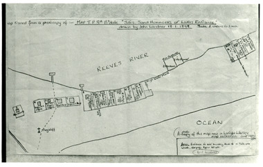
Photograph - New Works Plan, 1898
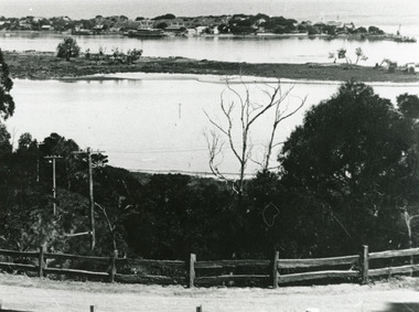
Map traced from a photocopy of :- Map TP8A Bairnsdale. 'Site. Sand Hummocks of Lakes Entrance'. Drawn by John Lardner 18 January 1898. Scale two chains to one inch. ( A photocopy of this map in Latrobe Library map collection, June 1983)Black and white photograph showing sketch map of 1898 by John Lardner Plan of Sites - sand hummocks. Drawing shows sites of buildings at entrance along Cunninghame Arm shoreline at Lakes Entrance, Victoria.land settlement, plan -
 Lakes Entrance Historical Society
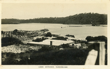
Postcard - New Works, Bulmer H D, 1910c
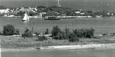
Also second copy same sizeBlack and white postcard showing view of Works buildings and north end of eastern pier. Cunninghame Arm and tip of Bullock Island and groyne work on right. Reeves channel and tip of Rigby Island on left. Mt Barkly and Kalimna Hills in background. Photo taken from top of dune. Roof of Carstairs boarding house centre foreground. Lakes Entrance VictoriaLakes Entrance, Cunninghamewaterways, settlement, historic buildings -
 Lakes Entrance Historical Society
Photograph - Carpentertown, Silver Reflections Studio, 1924c
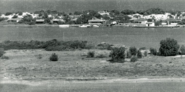
Black and white photograph showing view of New Works. Village on dunes at entrance to Gippsland Lakes from ocean - Bass Strait. View shows SS Gippsland at New Works wharf, Cunninghame Arm, part of Bullock Island and mouth of North Arm, post and rail fence along roadway down Jemmys Point. Lakes Entrance Victoriawaterways, islands, settlement -
 Lakes Entrance Historical Society
Photograph - Carpentertown, 1920c
Copied from copy in J Whadcoat collectionBlack and white photograph showing P W D cottage on left and other Works buildings on dune at the entrance to Gippsland Lakes from the ocean - Bass Strait. View shows flagstaff on top of dune and flagstaff jetty in lake - Cunninghame Arm. Small sailing boat on left and other small craft on shoreline. Section of Bullock Island with vegetation, one telegraph pole and one dead tree on island. Shoreline of North arm in foreground. Lakes Entrance Victoriajetties, waterways, settlement, historic site, boats and boating -
 Lakes Entrance Historical Society
Photograph - Carpentertown, 1920c
Copied from a copy in possession of J WhadcoatBlack and white photograph showing view of seven cottages on dunes. View of several boats at jetties and on slipway, white shed on New Works wharf, Cunninghame Arm in front of cottages, part of Bullock Island showing some vegetation and one telegraph pole. Lakes Entrance Victoriawaterways, islands, settlement -
 Lakes Entrance Historical Society
Photograph - New Works, 1890c
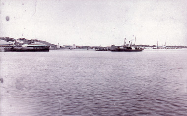
Three copies -Sepia photograph showing dunes, houses and Works buildings and boats at the entrance to Gippsland Lakes from ocean - Bass Strait. Photo shows two PWD houses on left and small school building, plus other Works buildings. Flagstaff on dune above houses. Large barge on left in front of houses. Large passenger steamer at New Works wharf with people waiting, has flags and bunting, two masted ketch on right of rock groynes. Lakes Entrance Victoriajetties, boats and boating, settlement, historic site -
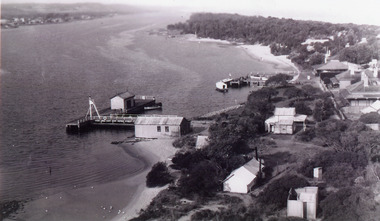 Lakes Entrance Historical Society
Photograph - New Works
Black and white photograph showing aerial view of Works buildings and cottages near man-made entrance to Gippsland Lakes Victoria boats and boating, topography, settlement, historic buildings -
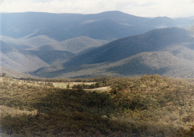 Lakes Entrance Historical Society
Photograph - Suggan Buggan, Tambo Shire, 1994 c
Also second identical copyColour photograph of the scenery in Suggan Buggan, showing very heavily forested mountainous country, a small area of cleared land centre left foreground. Suggan Buggan Victoriasettlement, agriculture, topography -
 MYLI My Community Library
Map - Nar Nar Goon County of Mornington Map, 1944, H.E Daw - Government Printer, June 1944
This was a map made in the period before Cardinia shire was created in 1994. With intricate labelling of lot allocations, this map is a invaluable research potential for understanding the settlement of the area and its development in the first half of the 1900s. A paper map with yellow shaded areas and black ink.On Left Side: Pakenham (lot numbers throughout the map) Top side: Gembrook, Tonimbuk Right Side: Bunyip, Koo-wee-rup East Bottom Side: By Authority: / H.E. Daw Government Printer / Melbourne Koo-wee-rup Bottom Right Corner: NOTE: The allotments colored brown are freehold. In respect of which the name. The Area, and the Date where given, are the particulars set out in the Crown grant as issued by the Lands Department. / After the issue of the Crown Grant, all subsequent dealings are effected at the office of titles, Queen Street, Melbourne, and particulars as to present registered ownership, boundaries, subdivisions, etc., may be obtained by search at that office. / This plan has been compiled from the Lands Department Record as at June 1944 / Nar-Nar-Goon / County of Mornington / Drawn and reproduced at the department of lands and survey, Melbourne Price 2/. June 1944 h.e. daw, map, nar-nar-goon, county of mornington, pakenham, koo-wee-rup -
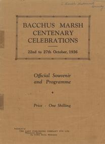 Bacchus Marsh & District Historical Society
Book, Bacchus Marsh centenary celebrations, 22nd to 27th October, 1936: Official souvenir and programme, 1936
A souvenir booklet produced in Bacchus Marsh to commemorate 100 years since the arrival of European colonists in the district Bacchus Marsh in 1836. It contains a brief history of European settlement in the area and a description of some of the major industries and infrastructure of the region. Also included are several black and white images of significant local buildings, parks, geographic features and a group portrait of shire councilors; Published by The Lady Publishing Company, Melbourne, 1936. Edited by F. C. McC Crisp; Online edition accessible from State Library of Victoria at: https://find.slv.vic.gov.au/permalink/61SLV_INST/1sev8ar/alma99837471360763628 pages. 25cm. BMDHS Location: AR/SU4non-fictionA souvenir booklet produced in Bacchus Marsh to commemorate 100 years since the arrival of European colonists in the district Bacchus Marsh in 1836. It contains a brief history of European settlement in the area and a description of some of the major industries and infrastructure of the region. Also included are several black and white images of significant local buildings, parks, geographic features and a group portrait of shire councilors; Published by The Lady Publishing Company, Melbourne, 1936. Edited by F. C. McC Crisp; Online edition accessible from State Library of Victoria at: https://find.slv.vic.gov.au/permalink/61SLV_INST/1sev8ar/alma998374713607636bacchus marsh history, centenaries bacchus marsh -
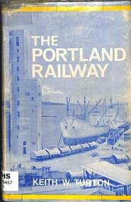 Victorian Railway History Library
Book, Turton, Keith, The Portland Railway, 1968
A history of the rail network based on Portland that was developed from the 1870s to transport goods between its port and the growing inland settlements of Western Victoria and Southeast South Australiaill, maps, p.179.non-fictionA history of the rail network based on Portland that was developed from the 1870s to transport goods between its port and the growing inland settlements of Western Victoria and Southeast South Australiarailroad construction - victoria - history, railroads -- victoria -- history -
 Bendigo Historical Society Inc.
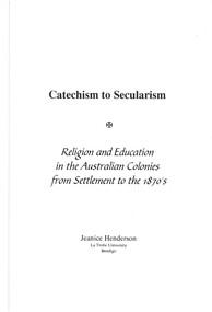
Document - CATECHISM TO SECULARISM - RELIGION AND EDUCATION IN THE AUSTRALIAN COLONIES FROM SETTLEMENT TO THE 1870S
BHS CollectionPrinted and bound paper delivered as the Amy Huxtable Memorial Lecture on 18 January 1998. Front cover is white with green printing with a perspex cover. Contains 20 pages of black printing and several tables and bibliography at the end. Discusses the ties between religion and education during the early part of Australia's history.Jeanice Henderson LaTrobe University Bendigo -
Merbein District Historical Society
Book, They Battled for Birdwood (c 1997), 1914-1997
max whiting, soldier settlement, james stevens, walter roy elliott, frank clifton sendy, garrett lyons, duncan james king, wallace crace bennet, henry herbert tiller, william frederick hodson, john lewis burrrell, john allan jacob whitney, john brown, stanley charles, philip joseph palmer, herbert charles neal, robert keddington rodwell, theophilus thomas walters, joseph whiting stanley, john percival cupper, alfred bromley, noel bean corbould, john mckenzie mcleod, alfred john mcgauchie, percival william walters, lionel stanley walters, ewen cameron kennedy -
Merbein District Historical Society
Book, Australia's Great River (c 1976 hard cover), 1909-1976
r.m. younger, elwood mead, soldier settlement, csiro, murray river -
Merbein District Historical Society
Book, Australia's Great River (c 1976 hard cover), 1909-1976
r.m. younger, elwood mead, soldier settlement, csiro, murray river -
Merbein District Historical Society
Book, Chaffey's Kingdom (1976), 1887-1965
mildura wines pty ltd, soldier settlements, wineries, chaffey -
Merbein District Historical Society
Newspaper, Sunraysia Daily - Magic Story of Mildura x2, 29 Aug.1984
elizabeth maffei (councillor), lord huntingfield's (governor) visit to merbein, merbein central school, merbein residents, merbein school committee, captain halhed, merbein brass band, a.j. chislett (councillor), aggies antiques, mildura co-op - merbein branch, mildura co-op birdwoodton branch, birdwoodton soldier settlement -
Merbein District Historical Society
Newspaper, Sunraysia Daily - Merbein Golden Jubilee Feature (2 copies), 18 Aug.1959
golden jubilee, merbein higher elementary school, land board, merbein cricket club, south merbein cricket club, merbein bowling club , merbein turf club, ana, mildura winery pty. ltd. (mildara), merbein victicultural research station, e.j. roberts, irymple packing company - merbein branch, mildura co-operative fruit company - merbein branch, merbein methodist church, merbein cwa, merbein baby health centre, birdwoodton soldier settlement, merbein rsl, nelson wellington (colonel), john mcleod, merbein guides, merbein rowing club, state rivers & water supply commission, merbein settlers progress association, big lizzie, women's welfare club, lake school, merbein dads association, commercial banking company of sydney ltd., murray valley horsemen's club -
Merbein District Historical Society
Book, Diamond Jublilee/Our Lady/Sacred Heart Primary School Merbein No1277, 1928-1988
schools, education, our lady of the sacred heart primary school, primary schools, catholic church, merbein irrigation settlement, edward joseph kenny -
Merbein District Historical Society
Book, Military Matters Snippets about Merbein Servicemen form WW1, 1914-1918
bronwyn zrna (compiler), soldier settlements, world war 1, harry buchecker, william birdwood (general sir), fred langdon, w.h. (harry) bruce, alfred charles cameron, william edward symthe, charles henry game, thomas edwin surgey, w.g. evans, richard rezin york, charles lawrence mitting, william silas allen, charles octavius barclay, robert harvey harcourt seggie, horace a. hart, kenneth charles cameron, bert jenner, harold e. jenner, william robert comb, walter ernest symthe, harry frederick bull, alan melrose hayes, james hogan, richard bright litchfield, william rainbow, frederick sanders, angus john foster, frederick holden foster, paul douglas kalmer, j.j. scarffe, killian patrick power, peter reilly -
Merbein District Historical Society
Book, They Battled for Birdwood (c 1997), 1914-1997
max whiting, soldier settlement, james stevens, walter roy elliott, frank clifton sendy, garrett lyons, duncan james king, wallace crace bennet, henry herbert tiller, william frederick hodson, john lewis burrrell, john allan jacob whitney, john brown, stanley charles, philip joseph palmer, herbert charles neal, robert keddington rodwell, theophilus thomas walters, joseph whitingstanley, john percival cupper, alfred bromley, noel bean corbould, john mckenzie mcleod, alfred john mcgauchie, percival william walters, lionel stanley walters, ewen cameron kennedy