Showing 3734 items
matching street map
-
 Port Melbourne Historical & Preservation Society
Plan - Water cart used in road construction, Borough of Sandridge, 21 Nov 1870
From a group of maps and plans not required by the Port Melbourne Council Engineering Department in May 1994 and offered at that time to the Port Melbourne Historical Society.Plan of water cart used in road construction including 4 diagrams and scales: signed by Borough Surveyor, Nov 21 1870.built environment - civic, engineering, engineering department - borough of sandridge -
Port Melbourne Historical & Preservation Society
Plan - Sandridge, Department of Lands and Survey, "The Township of Sandridge", 5 Nov 1860
Map of Sandridge, lithographed 1860, showing subdivisions on Evans Street, but no other development West of the railway Lihographed at the Department of lands and Survey, Melbourne 5th November 1860. Hand drawn annotations added at unknown date.Hand written "clay ground" 18 chains long, 7.5 chains broad, 26 chains from railwayengineering - roads streets lanes and footpaths, sandridge lagoon, transport - railways, town planning, local government - borough of sandridge -
 Port Melbourne Historical & Preservation Society
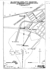
Map, Leading Lights of Port Melbourne Channel, 1926
Proposed arrangement of Leading Lights of mailboat channel at Port Melbourne piersbeacons, melbourne harbor trust - port of melbourne authority, leading lights -
Port Melbourne Historical & Preservation Society
Map - Route of US Navy Great White Fleet, 2008
Large photocopy of map of the world with the route of the Great White Fleet (US Navy) 1908 marked in red and white tapearmed services - navy, great white fleet, us navy -
Port Melbourne Historical & Preservation Society
Book, Jeff Leeuwenburg, "The Making of Melbourne in Maps", 1987
"The Making of Melbourne in Maps" by Jeff Leeuwenburg (1987), includes maps of Melbourne from 1836 to 1930built environment, jeff leeuwenburg -
Port Melbourne Historical & Preservation Society
Map, John Millar, "Design for Ship Canal or 'tidal harbor' and docks for the Port of Melbourne", 21 Sep 1860
COPYRIGHT STATE OF VICTORIA Hydrographic map. "Design for Ship Canal or 'tidal harbor' and docks for the Port of Melbourne". Shows proposed extension of the city westward. Signed 21.09.1860, lithographed 21.12.1860 and reproduced 1986transport - shipping, piers and wharves, engineering - canals and drainage, town planning -
 Port Melbourne Historical & Preservation Society
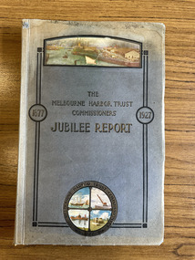
Book, Benjamin Hoare, "The Melbourne Harbor Trust Commissioners Jubilee report 1877-1927", 1927
The "Jubilee History of the Melbourne Harbor Trust" was compiled from the original records of the Trust and from the Victorian "Hansard". Incudes 485 pages of text, images and maps.melbourne harbor trust - port of melbourne authority, piers and wharves, transport - shipping, benjamin hoare -
Port Melbourne Historical & Preservation Society
Map - Chart, Port of Melbourne Authority, Port of Melbourne, 1994
Used in the library of The Polly Woodside Museum before closure1994 Chart of Port of Melbourne with updated annotations by Glen Stuart between 1994 and 2005port of melbourne authority, piers and wharves, melbourne harbor trust - port of melbourne authority, glen stuart -
Port Melbourne Historical & Preservation Society
Pamphlet - Promotional bike map of South Melbourne, Port Melbourne and St Kilda, "Explore by Bike", 1990s
Promotional bike map for the cities of South Melbourne, Port Melbourne and St Kildalocal government - city of port melbourne, local government, city of st kilda, city of south melbourne -
Port Melbourne Historical & Preservation Society
Book, Universal Business Directories (Aust) Pty Ltd, Universal DeLuxe Streets Directory, 1959
1959 Streets Directory for Melbourne City and Suburbs including large scale maps, hospitals, schools, police stations, town halls, telephone booths, tram stops, railways. Fifth edition. Red and Buff cardboard cover, red binding.transport - roads, street directory -
Port Melbourne Historical & Preservation Society
Map - MHT General Plan showing Harbour improvements recommended Sir John Coode, Thomas Kell Lith, 1800s
Black and white map "Melbourne Harbour Trust, General Plan showing Harbour improvements, as recommended by Sir John Coode in his report of 17th February 1879" Showing proposed Coode canal and Sandridge, Hobson's Bay, North Williamstown, Footscray, the City, Emerald Hill and also the buildings of "Kitchen and Son" . (copy of original)industry, manufacturing, engineering department, borough of sandridge, engineering - canals and drainage, melbourne harbor trust - port of melbourne authority, j kitchen & sons pty ltd, sir john coode -
Port Melbourne Historical & Preservation Society
Photograph - Aerial view of Port Melbourne, overlaid, Charter Keck, Cramer, Nov 2006
Black and White aerial photo with red map overlay, labelled "Port Melbourne 1946 overlaid" in gold/brown metal frame . Shows Yarra River, Coode Canal and Hobson's Bay.built environment - industrial, engineering - canals and drainage, coode island, yarra river, melbourne harbor trust - port of melbourne authority -
Port Melbourne Historical & Preservation Society
Map - Lagoon between Ingles and Spring Streets, Sandridge, 26 Mar 1872
Prepared by Mr ORME for the Lagoon Committee and presented with a report on 26.3.1872.Map of Lagoon between Ingles Street and Spring Street. 26 March 1872. In brown wooden frameBorough Surveyor's Stamp in bottom right hand corner.sandridge lagoon, mr orme -
Port Melbourne Historical & Preservation Society
Map - Lagoon and beach, Sandridge, Borough of Sandridge, 1870
Map of Lagoon and beach with soundings, 1870.Signed by Chas. Clay, Borough Surveyor, Sandridge.charles clay, sandridge lagoon -
Port Melbourne Historical & Preservation Society
Map, G S Williams, City Engineer, City of Port Melbourne, Dec 1963
Map of City of Port Melbourne (brick areas marked in colour), 1963.G. S. Williams (City Engineer)town planning, g s williams, troedel and cooper -
Port Melbourne Historical & Preservation Society
Map - Road plans for Fishermens Bend, R S Atkinson, 30 Apr 1946
CRB Map outlining road plans for Fishermens Bend and including the site of the Commonwealth Aircraft Corporation, Aerodrome, General Holdens and C.S.R.I., 1946transport - aviation and aerodrome, industry - manufacturing, fishermans bend -
Port Melbourne Historical & Preservation Society
Map - Williamstown, MMBW, 17 Jul 1894
Melbourne and Metropolitan Board of Works Plan for Williamstown, 1894.Signed W. Thwaites.melbourne and metropolitan board of works, mmbw, williamstown, william thwaites -
Port Melbourne Historical & Preservation Society
Map - City of South Melbourne, 1854 - 1884
Detailed map of City of South Melbourne. Date uncertain. Shows early configuration of river and docks."South Melbourne, Sheet 2"emerald hill, town planning -
Port Melbourne Historical & Preservation Society
Map - Wharves and Fisherman's Bend, MMBW, 17 Jan 1894
MMBW plan of Number 9 Wharf Area and Fisherman's Bend, 1894pencil writing addedmmbw, melbourne and metropolitan board of works, fishermans bend -
Port Melbourne Historical & Preservation Society
Map - West and North Melbourne, MMBW, 21 Feb 1936
Melbourne and Metropolitan Board of Works plan No 24 of West and North Melbourne Docklands,1936signed A.W. Walkermmbw, melbourne and metropolitan board of works, a w walker -
Port Melbourne Historical & Preservation Society
Map - Yarra River, Saltwater River and Coode's Canal, 1935
Plan No.7. Yarra River, Saltwater River, Coode's Canal area 1935.Signed Walker A.W.melbourne, a w walker, melbourne and metropolitan board of works, mmbw -
Port Melbourne Historical & Preservation Society
Map - Melbourne and suburbs, MMBW, 8 Dec 1909
MMBW map of Melbourne and suburbs - Record plan up to July 1st 1913 (scale 3/4" = 1 mile)engineering - board of works, calder e oliver, russwaul(?) -
Port Melbourne Historical & Preservation Society
Map - Settled districts around Melbourne, 1850s
Map of the settled districts around Melbourne in the Colony of Victoria, late 1850smelbourne -
Port Melbourne Historical & Preservation Society
Map - County of Bourke, Thomas Bibbs, 1866
Map of the County of Bourke, 1886melbourne -
Port Melbourne Historical & Preservation Society
Map - Aerial view of Port Melbourne, Melbourne Harbor Trust, Apr 1944
Drawing of aerial view of Port Melbourne 1944piers and wharves - miscellaneous, missions to seamen, melbourne harbor trust - port of melbourne authority -
Port Melbourne Historical & Preservation Society
Document - Report, Valuation of freehold property in Victoria of Unilever Australia Pty Ltd, K L Dowling & Co, Valuation and Report as at 1st January 1982, on freehold property in Victoria of Unilever Australia Proprietary Limited, 9 Aug 1982
Valuation and Report as at 1st January 1982, on freehold property in Victoria of Unilever Australia Proprietary Limited. Typed report in blue plastic cover with lists, maps, valuations and title deed copies for Unilever Australia P/L property at 164 Ingles St, Port Melbourne. Part of J Kitchens collectionindustry - manufacturing, built environment - industrial, j kitchen & sons pty ltd, unilever australia (holdings) ltd, unichema australia pty ltd -
Port Melbourne Historical & Preservation Society
Letter - Office of Lands & Survey re permission to build a boat on Sandridge Beach, Secretary for Lands, 22 Jun 1876
Photo\copies of letter and small map from Office of Lands & Survey, 22 June 1876. Re permission to lease land to build a boat on Sandridge Beach. Original letter sent to J.C. Lowrie of Stokes Street. Various copies stapled together.local government - borough of sandridge, j c lowrie, sandridge beach -
Port Melbourne Historical & Preservation Society
Book, Phyllis Albinson Kelly, "Port Melbourne's Child - Memories of early years in Pickles Street", Oct 2005
Produced in conjuction with the Women of Port Melbourne exhibition and launched 20.10.2005 at the Port Melbourne library by History Librarian Kay Rowan. Phyllis lives in Williamstown but revisits Port often. .01- note that this copy was signed by the author, but is the first incorrect printing. A caption on page 2 was altered and a paragraph changed on page 6 to eliminate personal reference and the first print supposedly destroyed so it is unknown how she obtained this copy."Port Melbourne"s Child - Memories of early years in Pickles Street" A5 book, 24 pages with 9 photos and map, by Phyllis Albinson Kelly. Yellow ochre cover Misprinted edition erroneously signed by author Signed by the author "To Port Melbourne Historical Society - Thank You - Phyllis Kellyfamilies, built environment, education, war - world war ii, health - general health, phyllis albinson kelly, knights staples, dawsons emporium, our lady of mt carmel -
Port Melbourne Historical & Preservation Society
Book, Phyllis Albinson Kelly, "Port Melbourne's Child - Memories of early years in Pickles Street", Oct 2005
"Port Melbourne"s Child - Memories of early years in Pickles Street" A5 book, 24 pages with 9 photos and map, by Phyllis Albinson Kelly. Yellow ochre cover Corrected (unsigned) second printingfamilies, built environment, education, war - world war ii, health - general health, phyllis albinson kelly, staples knights, dawsons emporium, our lady of mt carmel -
Port Melbourne Historical & Preservation Society
Poster, History of a Street Precinct
A cultural grant was given to Margaret BRIDE to implement this study, which she did with the help of her husband Graham and several residents of the study area including PMH&PS members Emily LOCK, David THOMPSON, Jack BOLT and Kerrie MATHEE.History of a Street Precinct, documenting 80 years plus of the history of the area bounded by Williamstown Road and Evans, Bridge and Farrell Streets, since 1880. One of two products of a 2005 project (which subsequently won the 2007 Victorian Local History Award for research). A brochure containing a map of the area and photos and information on key properties. An interactive CD (2148.02) containing information and photographs on 91 buildings and their occupants over time was also produced. built environment