Showing 1988 items matching "victoria bridge"
-
 Lakes Entrance Historical Society
Photograph - Kalimna, Bulmer H D, 1940c
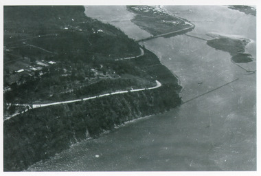
Black and white photograph of aerial view of Kalimna escarpment, Princes Highway, road to Kalimna Hotel, scattering of buildings including Gainsborough House, in distance is North Arm bridge, footbridge to undeveloped Bullock Island with rock groynes in place. Part of eastern pier of entrance at Lakes Entrance, Victoria. waterways, topography, township, bridges -
 Lakes Entrance Historical Society
Photograph - Kalimna, Bulmer H D, 1940c
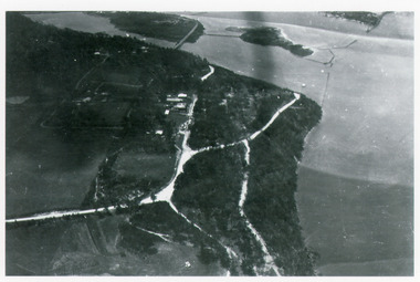
Black and white photograph of aerial view of Kalimna Heights, showing scattered buildings, Princes Highway around side of cliff, western end of township, North Arm bridge, footbridge to Bullock Island, and rock groynes. Track to lookout and signal beacon visible. Lakes Entrance Victoria waterways, roads and streets, bridges, township -
 Lakes Entrance Historical Society
Photograph - Floods, 1919
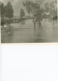
Black and white photograph showing Mitchell River in flood at the old highway bridge at east end of town. Roof of Imperial Hotel in background at far end of bridge, trees and fences under water in foreground. Bairnsdale Victoriabridges, flooding -
 Lakes Entrance Historical Society
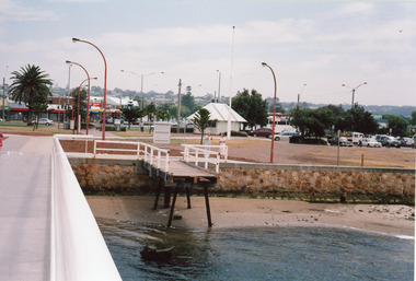
Photograph - Bridges, Lakes Post Newspaper, 1999
... . Lakes Entrance Victoria Photograph Bridges Lakes Post Newspaper ...Image appeared in Lakes Post 19 May 1999|Also two other photographs similarColour photograph of repairs to the Cunninghame Arm Footbridge, shows Burys Slipway barge and workmen. Surf Lifesaving Clubroom on dunes in distance. Lakes Entrance Victoriabridges, waterways, topography -
 Lakes Entrance Historical Society
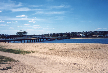
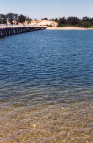
Photograph - Footbridge, 2009
plus 6 other photos Color photographs of the demolition of the old timber bridge across Cunninghame Arm, Lakes Entrance, Victoria.bridges, government, celebrations -
 Lakes Entrance Historical Society
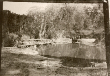
Photograph - Bridges, 1910
... of water. Lakes Entrance Victoria Photograph Bridges ...Also black and white identical copy 10 x 15 cm, donated by Marion Holding. 02288.1Sepia toned photograph of the old road crossing at Bunga Creek, between Lake Tyers and Lakes Entrance. It shows a rustic footbridge over waterway beside flooded road, horse and buggy with man and woman on board at edge of water. Lakes Entrance Victoriabridges, waterways -
 Lakes Entrance Historical Society
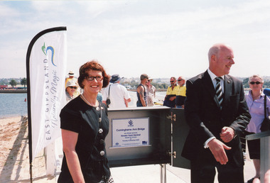
Photograph - Footbridge, 2009
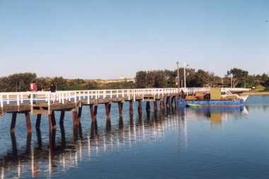
Date made 12 November 2009, 3 other photosColour photograph taken at the official opening of the new footbridge across Cunninghame Arm, Lakes Entrance, Victoria.bridges, transport, waterways, celebration, local history -
 Lakes Entrance Historical Society
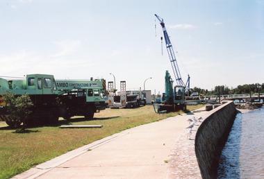
Photograph, 2008
Date made December 2008 plus 7 other photosColour photograph of building of the new footbridge over Cunninghame Arm showing method of construction and application of concrete surface. Lakes Entrance Victoriabridges, waterways, construction -
 Lakes Entrance Historical Society
Photograph, 1947
1/02/1947 12:00:00 AMBlack and white photograph of the Princes Highway bridge over Bunga Creek showing the sharp bend in the road as it crosses the creek east of Lakes Entrance Victoriabridges, transport, roads and streets -
 Lakes Entrance Historical Society
Photograph - Bridges, 1930
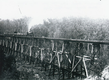
... . Nowa Nowa Victoria. Photograph Bridges ...Also similar black and white copy 15 x 22 cmBlack and white photograph showing the trestle bridge over Stoney Creek near Nowa Nowa, shows Bairnsdale to Orbost train on left end of bridge. Train has four open goods trucks, two covered goods trucks, one louvred van and one passenger carriage, and guards van at rear. Tall forest in background, low scrub in front. Nowa Nowa Victoria.bridges, transport -
 Lakes Entrance Historical Society
Photograph, 1932
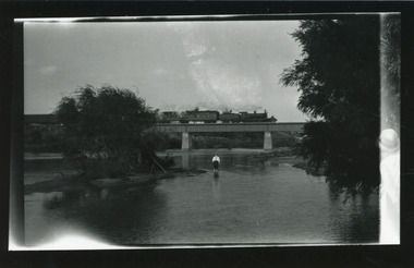
Bairnsdale or Orbost railway closed to passengers 27 April 1935Black and white photograph of a steam train passing over the Tambo River bridge showing a passenger carriage behind the locomotive, man paddling in river. Bruthen Victoriabridges, transport -
 Lakes Entrance Historical Society
Photograph, 1940
Black and white photograph of a railway bridge over waterway on railway line at unknown location. Boat at edge of water has small load of log timbers across it. Victoriabridges, transport, vegetation -
 Lakes Entrance Historical Society
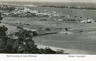
Postcard - Lakes Entrance, Bulmer H D, 1935
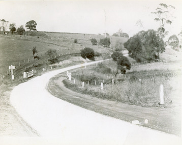
Marine Parade has not yet been formed through the low lying marshy area adjacent to North Arm. Very little vegetation on Eastern end of hummocks.Black and white postcard of the western end of Lakes Entrance,showing a glimpse of the North Arm bridge, town situated adjacent to Cunninghame Arm, sand hummocks and ocean in distance. Lakes Entrance VictoriaThe Township at Lakes Entrancetownship, waterways, bridges, hotels -
 Lakes Entrance Historical Society
Photograph - Footbridge, Lake Post Newspaper, 1999
Colour photograph of the Cunninghame Arm Footbridge, showing the excavation of sand after removal of Kiosk, prior to construction of new Surf Lifesaving Clubrooms. Lakes Entrance Victoriabridges, waterways, construction -
 Lakes Entrance Historical Society
Photograph - Bridges, 1999
... Clubrooms. Lakes Entrance Victoria Photograph Bridges ...Date made December 1999Colour photograph of the Cunninghame Arm Footbridge, showing the excavation of sand after removal of Kiosk, prior to construction of new Surf Lifesaving Clubrooms. Lakes Entrance Victoriabridges, waterways -
 Lakes Entrance Historical Society
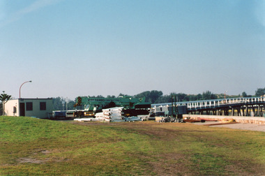
Photograph - Footbridge, 2008
Date made December 2008Colour photograph showing setting up of worksite and commencement of construction of new Footbridge over Cunninghame Arm, including installation of steel piers. Lakes Entrance Victoria,bridges, waterways, construction -
 Lakes Entrance Historical Society
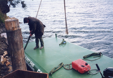
Photograph - Barges, Lakes Post Newspaper, 1999
Photo and article appeared in the Lakes Post Newspaper 28 July 1999|Barge was built by Wayne Smith for the firm East Gippsland Bridges.|Also two other photographs similarColour photograph of the launching of a new work barge in the Tambo River, Victoria.boats and boating, waterways, barges -
 Lakes Entrance Historical Society
Photograph - Bridges, Wiblin, Meg, 2011
... intact. Nowa Nowa Victoria Photograph Bridges Wiblin, Meg ...Date made December 2011|This bridge is one of the few remaining of the several constructed on the Bairnsdale to Orbost railway line from 1913 to 1915.|Also eight photographs similar views, four taken of the top, four from below the bridgeColour photograph showing different views if the timber railway trestle bridge at Wairewa. Railway line and sleepers have been removed, structure appears to be reasonably intact. Nowa Nowa Victoriabridges, historic site, transport -
 Lakes Entrance Historical Society
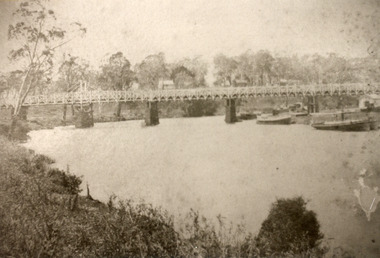
Photograph - Bridges, Bulmer, H D, 1887
... , Victoria. Photograph Bridges Bulmer, H D ...Black and white photograph of the first road bridge over the Mitchell River at Bairnsdale, Victoria.township, waterways, bridges -
 Lakes Entrance Historical Society
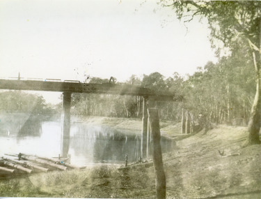
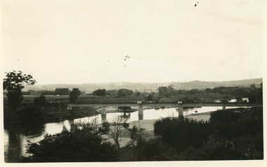
Photograph - Bridges, 1924
... , Victoria. Photograph Bridges ...February 1924 date made.Black and white photograph of the railway bridge over the Tambo River at Bruthen, Victoria.bridges, waterways -
 Lakes Entrance Historical Society
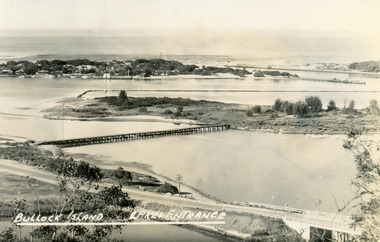
Postcard - Bullock Island, Bulmer H D, 1945
Black and white postcard of Bullock Island, Lakes Entrance, showing an extensive rock groyne to the south of the island, into which dredged sand and spoil is to be placed in order to extend the island's area. North Arm bridge, Bullock Island footbridge, New Works settlement and Entrance channel also in image. Lakes Entrance VictoriaBullock Island, Lakes Entranceboats and boating, fishing industry, islands -
 Lakes Entrance Historical Society
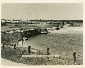
Postcard - Lakes Entrance, 1955
... Black and white photograph of North Arm bridge Lakes... and white photograph of North Arm bridge Lakes Entrance Victoria ...The Marine Parade has been formedBlack and white photograph of North Arm bridge Lakes Entrance VictoriaNorth Arm and Bridge Lakes Entrance, Vicwaterways, roads and streets, bridges -
 Eltham District Historical Society Inc
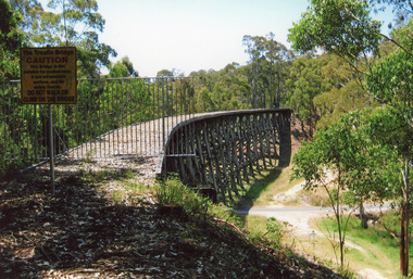
Photograph, Alice Elwers, Eltham Railway Bridge, 1976
... View of the Eltham Railway trestle bridge near Eltham Town...View of the Eltham Railway trestle bridge near Eltham Town ...View of the Eltham Railway trestle bridge near Eltham Town Park with a train either approaching or leaving Eltham Station. A Tait 'red rattler' train is on the railway. The railway was commenced in 1900 and opened in 1902. It crosses the Diamond Creek on a timber trestle bridge just below where the Eltham Library stands today to the right on this view. The line was electrified in 1923. It is one of the few remaining similiar bridges remaining in Victoria. In 1976 when this was image was taken, Victorian Railways commenced works under the bridge to replace it with an earth embankment and large culvert pipes. This was abandoned following pressure from the Shire of Eltham and community protests. Colour photographbridges, railways, eltham, trestle bridge, eltham town park -
 Eltham District Historical Society Inc
Photograph - Digital Photograph, Alan King, Eltham Railway Trestle Bridge, 28 December 2007
Covered under National Trust of Australia (Victoria) State Significance and Heritage Overlay, Nillumbik Planning Scheme. Published: Nillumbik Now and Then / Marguerite Marshall 2008; photographs Alan King with Marguerite Marshall.; p103 The Eltham railway trestle bridge is the only one of its kind still regularly used in Melbourne’s metropolitan railway network. Opened in 1902, it is also one of Victoria’s very few timber rail bridges that still carries trains.1 The bridge is part of the railway line extension from Heidelberg - extended to Hurstbridge in 1912. This extension resulted in one of the greatest social changes experienced in Eltham Shire, as it considerably lessened its isolation attracting tourists, artists and suburban commuters particularly after World War Two.2 The bridge has been classified by the National Trust as historically, scientifically, aesthetically and socially significant at state level. But this has not always been recognised, and in 1977, locals fought to save it from destruction. The Victorian Railways proposed to replace the bridge with an earth embankment and large culverts to avoid maintenance problems and fire. This was rejected by the Eltham Council who protested that the bridge helped maintain the area’s rural character, historic link and beauty, as well as avoiding possible serious flooding on the flood plain if a culvert was blocked. The bridge stands as part of a National Trust classified landscape which includes the Alistair Knox Park, named after the local conservationist and architect who helped to make Eltham famous for its mud-brick houses. The landscape includes tall and spreading manna gums and candlebarks, and the historic Shillinglaw Cottage. Artist Walter Withers, one of the Heidelberg School of painters, painted the bridge early in the 20th century. The 38 span single-track railway bridge over creek and road has 34 timber-beam spans and four steel-joist spans, supported by four-pile timber piers and timber abutments. It has almost 200m of timber deck. All of the timbers have been replaced over the years, but the only change to the bridge’s character was the addition of pylons and wiring for electric trains in 1923. A petition for a railway to the shire was first made in 1883. A large deputation of local citizens to the Commissioner of Railways proposed a route passing through Alphington to midway between Greensborough and Eltham up the Diamond Creek valley towards Queenstown and Kinglake. As a result the Princes Bridge-Heidelberg Railway was opened in 1888. From 1888 locals demanded a railway extension. Kangaroo Ground farmers in particular, led by Shire Councillor and Member for Evelyn, Ewen Cameron, said it would assist local farmers and orchardists send their produce to the Melbourne market. In 1890, before the severe economic Depression, an extension of the line to Hurst’s Bridge (now Hurstbridge) was included in a new Railways Bill. The parliamentary delegations were regaled with a banquet at Hurst’s barn and entertained by the Diamond Creek Brass Band, but the extension was abandoned when the Depression struck in 1892-1893. The extension of the railway to Eltham, completed in 1902, was one of the few built in those hard times. That is why the Eltham timber-trestle railway bridge is a rare example of a broad-gauge rail bridge constructed between 1893 and 1910. At the opening, despite persistent drizzle, 300 children waving flags and banners were among the large crowd welcoming the first train, carrying official dignitaries, to Eltham. It had taken 24 years to bring the railway to Eltham. From then Eltham became a popular destination for outings. Mr Orford of Eltham recalled that after the railway came to Eltham ‘the craze for picnics on weekends and holidays began…. During the wattle season, wattle trains came to Eltham frequently. The visitors roamed the creek pulling great armfuls of wattle blossom to take back with them to Melbourne’.3 In 1926 the railway line was electrified as part of the metropolitan rail network. But the Victorian Railways decided not to complete the formerly planned Diamond Valley Railway to Queenstown (now St Andrews) and Kinglake.This collection of almost 130 photos about places and people within the Shire of Nillumbik, an urban and rural municipality in Melbourne's north, contributes to an understanding of the history of the Shire. Published in 2008 immediately prior to the Black Saturday bushfires of February 7, 2009, it documents sites that were impacted, and in some cases destroyed by the fires. It includes photographs taken especially for the publication, creating a unique time capsule representing the Shire in the early 21st century. It remains the most recent comprehenesive publication devoted to the Shire's history connecting local residents to the past. nillumbik now and then (marshall-king) collection, eltham railway trestle bridge, eltham trestle bridge -
 Eltham District Historical Society Inc
Photograph - Digital Photograph, Alan King, Monash Bridge, Hurstbridge, 23 January 2008
Monash Bridge spans the Diamond Creek at Hurstbridge. It was built in 1917 for the Shires of Heidelberg, Eltham and Whittlesea. It is considered Nillumbik Shire's finest engineered bridge and was construced by the engineering company of Sir John Monash. Covered under Heritage Overlay, Nillumbik Planning Scheme. Published: Nillumbik Now and Then / Marguerite Marshall 2008; photographs Alan King with Marguerite Marshall.; p117 Monash Bridge is considered the Shire’s finest engineered bridge and was constructed by the engineering company of that great Australian, Sir John Monash.1 The bridge spans Diamond Creek on the Hurstbridge-Arthurs Creek Road, linking Hurstbridge with Yarrambat and Arthurs Creek. Monash Bridge, also called Hurst’s Bridge, was built in 1917, by the Reinforced Concrete and Monier Pipe Construction Company Pty Ltd, for the Shires of Heidelberg, Eltham and Whittlesea. Although Monash was probably in action overseas during World War One when the bridge was designed and constructed, he evolved the basic design in the 1900s and it was a standard design for the firm. However J A Laing, a designer at the firm, was probably the designer, as his initials are on bridge drawings held by the Eltham District Historical Society.2 The bridge is an excellent early Australian example of an open spandrel reinforced concrete arch bridge and has a single span of 29 metres. It is unusual in Victoria, but similar to many reinforced concrete arch bridges in Europe and America, built from the late 19th century. In Victoria, Monash pioneered the use of reinforced concrete – then a revolutionary construction material. His company, Monash & Anderson, had the exclusive licence for the Monier patent for the system of reinforced concrete construction for Victoria and New South Wales. A well-known example of the Monier arch bridge is the Morell Bridge in South Yarra. The sweeping arch of the Monash Bridge combines grace and utility and blends with the surrounding rural landscape. Its design and construction have allowed it to carry increasing volumes of heavy traffic, but in modern times the one lane is considered by some to prevent easy passage through Hurstbridge. However others consider this an asset to deter too much more traffic, which would diminish Hurstbridge’s charming rural character.3 This is the third bridge across the Diamond Creek at this site. The original bridge was a log bridge upstream, constructed in the 1850s by early settler, Henry Hurst, after whom Hurstbridge was named. The bridge spanned the creek, where it divided his family’s property. In the 1880s a timber bridge replaced it, known as Hurst’s Bridge. However a more permanent bridge was considered necessary when the new railway arrived in 1912, bringing with it expectations of growth in the town and the surrounding fruit-growing district. Monash Bridge’s official opening on November 3, 1917 was a gala occasion, which took place before about 1000 spectators. Two who attended the opening had a particularly sound knowledge of the locality. One was Fred Hurst, Henry’s brother, who used to ford the creek at or near the bridge’s site more than 50 years before. The other was John McDonald of Arthurs Creek, who had built the old wooden bridge over the creek about 40 years earlier.4 Although John Monash was a fine engineer, his fame came from his brilliant war career, rather than from his engineering or his many other achievements. Monash was Corps Commander of the Australian Forces. His brilliance was recognised with his awards: Knight Grand Cross of the Order of St. Michael and St. George, and Knight Commander of the Bath. Monash was also decorated by the French, Belgian, and American Governments.5 After the war, Monash worked in many prominent civilian positions, the most notable as head of the Victorian State Electricity Commission. He was a leading and loved public figure, involved in many public and private organisations. He was president of the Australian Zionist Federation and involved in the Boy Scouts. Monash University is named after him. By the 1920s Monash was probably regarded as the greatest living Australian.6 Despite most of his life working as an administrator and leader, rather than a fighting soldier, he became integral to the ANZAC legend. Monash died in 1931.This collection of almost 130 photos about places and people within the Shire of Nillumbik, an urban and rural municipality in Melbourne's north, contributes to an understanding of the history of the Shire. Published in 2008 immediately prior to the Black Saturday bushfires of February 7, 2009, it documents sites that were impacted, and in some cases destroyed by the fires. It includes photographs taken especially for the publication, creating a unique time capsule representing the Shire in the early 21st century. It remains the most recent comprehenesive publication devoted to the Shire's history connecting local residents to the past. nillumbik now and then (marshall-king) collection, hurstbridge, monash bridge -
 Eltham District Historical Society Inc
Photograph - Digital Photograph, Marguerite Marshall, Sutherland Home for Children, Diamond Creek, 27 September 2007
The Sutherland Homes for Children on Yan Yean Road, Diamond Creek cared for thousands of children from when it was opened in 1912. The site closed for this purpose in 1991 and was sold and later developed for commercial and office purposes. Covered under Heritage Overlay, Nillumbik Planning Scheme. Published: Nillumbik Now and Then / Marguerite Marshall 2008; photographs Alan King with Marguerite Marshall.; p107 The Sutherland Homes for Children at 14 Yan Yean Road, Diamond Creek, cared for thousands of children since they opened in 1912, after beginning at La Trobe Street, Melbourne in 1908. In 1994 Sutherland Homes (then called Sutherland Child, Youth and Family Services) amalgamated with Berry Street Child and Family Welfare. Together as Berry Street Victoria, they formed Victoria’s largest independent provider of support and accommodation services for children, young people and families in crisis.1 However with the move from institutional to community care, the Diamond Creek site had not been used since 1991 and was sold to private purchasers in 1999. More than 2000 former residents, staff, neighbours and friends attended a farewell in February, 2000.2 The Sutherland Homes red-brick and stuccoed building in Diamond Creek (a rare design in the Eltham Shire), was opened in 1929 by Lord Somers, the Governor of Victoria. Destitute children lived in dormitories bathed in natural light through large windows. However in 1958 as the cottage–parent system replaced the dormitory system, the first of eight residential cottages accommodating ten to 12 children was built. The site also included Special School 3660 and a farm, and the children were able to form relationships with people outside Sutherland, by staying with holiday hosts. Children were originally placed at Sutherland because of extreme poverty, or because single parents could not cope. However later, most placements occurred due to family violence, abuse or neglect. The property was originally bought from the Crown in 1869 by Timothy Mahony. Later owner, Augusta Meglin, ran a 40-acre (16ha) farm there. In 1909 she bequeathed this, including the house, orchards, vegetable gardens, vineyards and the balance of her income to The Sutherland Homes for Neglected Children. Sutherland Homes’ founder, Selina Sutherland, was known as ‘New Zealand’s Florence Nightingale’. In 1888 she became Victoria’s first licensed ‘child rescuer’3 and was to rescue around 3000 waifs from Victoria’s streets and slums.4 Born in Scotland in 1839, Sutherland joined her sister, who had emigrated with her husband to New Zealand. Sutherland trained as a nurse and led the establishment of a public hospital at Masterton. In 1881, while holidaying in Melbourne, Sutherland was so touched by seeing young people living under Princes Bridge, that this determined her future work. Meanwhile Sutherland instigated the Melbourne District Nursing Society, (now Royal District Nursing Service). She also led the founding of The Victorian Neglected Children’s Aid Society (now Oz Child) and the Presbyterian Neglected Children’s Aid Society (now Kildonan). From 1894 Miss Sutherland was Melbourne’s best known woman and cut a distinctive figure, wearing an alpine hat with a prominent feather. In 1906 Prime Minister Alfred Deakin named her Melbourne’s most successful philanthropic worker. However she was to face some difficult times. That year she suffered severely from an injured shoulder and dizzy turns and was pressured to resign as Superintendent of The Victorian Neglected Children’s Aid Society. In 1908 the committee of management offered her 12 months leave with pay. Sutherland declined – but soon after, was dismissed. However she continued her work from Latrobe Street, Melbourne, with the help of Sister Ellen Sanderson and several committee members. Sutherland attempted to register her new organisation but the Victorian Neglected Children’s Aid Society objected to the government, alleging that Sutherland, because of increasing infirmity, was unable to satisfactorily carry out such duties. They accused her of cruelty and of intoxication. However the charges were not proven, so The Sutherland Homes for Neglected Children was registered.5 Sadly, in 1909 Sutherland died, the day she was to move the children to the ‘country property’ at Diamond Creek. At her death she owned less than £10. Today Berry Street recognises Sutherland’s enormous contribution to child welfare with a memorial and an annual Selina Sutherland Award, presented to an outstanding volunteer.This collection of almost 130 photos about places and people within the Shire of Nillumbik, an urban and rural municipality in Melbourne's north, contributes to an understanding of the history of the Shire. Published in 2008 immediately prior to the Black Saturday bushfires of February 7, 2009, it documents sites that were impacted, and in some cases destroyed by the fires. It includes photographs taken especially for the publication, creating a unique time capsule representing the Shire in the early 21st century. It remains the most recent comprehenesive publication devoted to the Shire's history connecting local residents to the past. nillumbik now and then (marshall-king) collection, diamond creek, sutherland home for children -
 Melbourne Tram Museum
Pamphlet, Yarra Trams, Buses Replace Trams - Routes 58, 59, 86 and 96, 2022
.1 - pamphlet provided at tram stops giving details of the works and bus services for routes 58 and 59 .2 - Project document describing the work and dates - downloaded from the Yarra Trams website after buses were used to replace route 58 from the Royal Children's Hospital rather than from Royal Park Station as originally planned. .3 - as for .1 - for the upgrading of the Merri Creek Bridge - route 86 - see also Reg Item 6066 .4 - as for .1 - for the installation of superstops in Nicholson St between Elgin St and Holden St - route 96Shows the methods that Yarra Trams customers are advised of changes due to track replacement works..1 - Pamphlet - DL, four fold printed on off white paper titled - Buses Replace Trams - Route 58 and Route 59 - Jan 2022 .2 - Project sheet - 3 A4 sheets, titled "Renewal works: Essendon Depot and Mt Alexander Road - 3.1 to 18.1.2022. .3 - Pamphlet - DL 3 fold, Buses Replace Trams, route 86, November 2021 - Merrit Creek Bridge works .4 - Pamphlet - DL - 4 fold, Buses Replace Trams, route 96, January 2020 - Nicholson St works for tram super stops.mt alexander road, tram works, track work, route 58, route 59, yarra trams, ptv, essendon tram depot, route 86, route 96, nicholson st, merri creek, bridges, carlton, super stops, trams, tramways, northcote -
 Melbourne Tram Museum
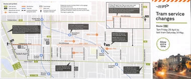
Pamphlet, Public Transport Victoria (PTV), Tram Service Changes, 2022
Pamphlet provided at tram stops giving details of the works and bus services for: .1 - route 72 track reconstruction between Chapel St and Orrong Road, in Malvern Road including the Orrong Road over rail line bridge - 29-4-2022 to 14-5-2022 .2 - All Collins and William St routes for the installation of a super stop in William St at Collins St - - 2-2-2022 to 6-2-2022Shows the methods that Yarra Trams and Public Transport Victoria customers are advised of changes due to track replacement works..1 - Pamphlet - DL, five fold DL - Tram service changes - route 72 - 29-4-2022 to 14-5-2022 .2 - Pamphlet - DL, four fold DL - changes in Collins and William Streets - 2-2-2022 to 6-2-2022tram works, track work, yarra trams, ptv, bridges, trams, tramways, route 72, malvern road, orrong road, super stops, collins st, william st -
 Melbourne Tram Museum
Photograph - Photo card Melbourne album sheets 1920c
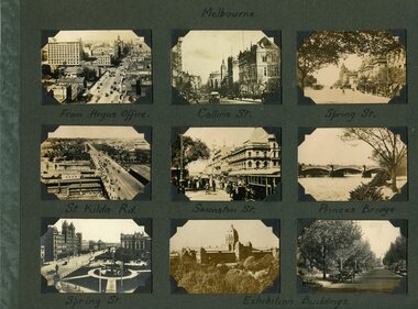
Part of an album of photo cards - cigarette card size - that depicted Melbourne and other country towns c1920. Sheet 1 - Melbourne - Elizabeth St, Collins St, Spring St, St Kilda Rd, Swanston St, Princes Bridge and Exhibition buildings. Sheet 2 - Healesville, Lorne, Brighton, Albury, Bendigo, Woori Yallock and Queenscliff - three cards have been removed prior to acquisition. Sheet 3 - Queen Victoria Gardens, Alexandra Avenue, Exhibition Gardens, St Kilda Road, Botanic Gardens - three cards have been removed prior to acquisition.Set of three album sheets containing up to 9 small printed photos on each sheet of Melbourne and some country towns.melbourne, victoria, tramways, gardens -
 Victorian Railway History Library
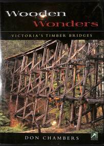
Book, Chambers, Don, Wooden Wonders: Victoria's Timber Bridges, 2006
... Bridges - Victoria - Design and construction Bridges ...A history of wooden bridges in Victoria, rail, road and pedestrian.index, ill, maps, p.207.A history of wooden bridges in Victoria, rail, road and pedestrian.bridges - victoria - design and construction, bridges - victoria - history