Showing 10466 items
matching plan
-
 Bendigo Military Museum
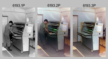
Photograph - Print Technician operating a Plan Printer at the Army Survey Regiment, Fortuna Villa Bendigo, 1990
These three photographs were most likely taken in the 1990s in Lithographic Squadron at the Army Survey Regiment, Fortuna, Bendigo. In photos .1P to .2P the Print Technician is using the Admal Plan Printer to process the exposed contone (black & white) copy of a map sheet. This is a set of three photographs of a print technician operating a Plan Printer at the Army Survey Regiment, Bendigo c1990s. The photographs were on 35mm negative film and were scanned at 96 dpi. They are part of the Army Survey Regiment’s Collection. .1) - Photo, black & white, c1990s, CPL Roy Hicks operating Admal Plan Printer. .2) - Photo, colour, c1990s, CPL Roy Hicks operating Admal Plan Printer. .3) - Photo, colour, c1990s, Admal Plan Printer. .1P to .3P – there are no annotations.royal australian survey corps, rasvy, army survey regiment, army svy regt, fortuna, asr, litho -
 Bendigo Historical Society Inc.
Plan - MARKS COLLECTION: PLAN FOR FOUR LEVEL STAIRCASE TOWER TO GARDEN ELEVATION AT FORTUINA VILLA FOR GEO. LANSELL ESQ
Plan for four level staircase tower to the Garden Elevation of Fortuna Villa, Sandhurst for George Lansell Esq. Plan details: * Plan shows ground, First, second and third floor plans for the staircase construction * First and second floor house plans and location of staircase addition * Front and Garden elevations with staircase addition Plan coloured and damaged on LHS, also with water damage -
 Greensborough Historical Society
Document, Amendment C78 to the Nillumbik Planning Scheme, 03/09/2012
The planning scheme amendment is to extend protection to a group of Pioneer Children's graves and an historic apple tree.The graves are from the pioneering Whatmough and Partington families. The apple tree is the surviving remnant of a former orchard on the site and is believed to have been purchased from the estate of John Batman.A 16 page collection of documents sent to GHS Committee member Anne Paul regarding an amendment to the Nillumbik Planning Scheme.Niljohn batman, batman apple tree, whatmough, partington, plenty river, pioneer childrens graves, plenty river trail, nillumbik shire council, greensborough, c78 -
University of Melbourne, Burnley Campus Archives
Plan - Photocopy, Percy Everett, New School of Primary Agriculture & Horticulture - Burnley Gardens, 1945
Floor plans and elevations of new building designed by Percy Everett, Chief Architect, Public Works DepartmentPhotocopies, reduced in size, of Original Plans for the Administrative Building. Signed, Percy Everett, Chief Architect, Dept of Public Works, Victoria, dated 26.09.1945 (1) UCB.2.135 Ground Floor and First Floor. (2) UCB.2.136 Transverse Section, Longitudinal Section. N.B. University of Melbourne - Property and Services has a better copy.buildings, percy everett -
 Melbourne Tram Museum
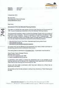
Document - Notice to Employees, Yarra Trams, "Kooyong Rail Square - Operating Procedure", Jan 2008
Document provides information on the operation of the rail square (also known as a tram square, railway Square) at the Kooyong Glenferrie Road level crossing. Provides a site plan, signal information and operational procedures including when items fail. Dated 16/1/2008.Demonstrates an instruction into the operation of the Kooyong rail squareSingle A4 sheet, printed double sided, with a coloured site plan.trams, tramway square, rail square, railway square, glenferrie road, kooyong level crossing, operations, instructions -
 University of Melbourne, Burnley Campus Archives
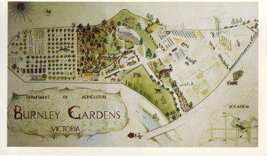
Slide - Colour slide, Milton Gellert, Department of Agriculture Burnley Gardens Victoria, 1955-1990
Copied for use as a postcard for the Centennial Year in 1990. Note by T.H. Kneen 18 March 1992, "The original drawing was done by Milton Gellert and for a considerable time was displayed in the Fruit Preserving Branch's display window. This was Milton's own concept and was probably done in late 50's. Milton was on Burnley Staff 1955-57 & then employed at Plant Research Institute, Burnley Gardens." The picture was later hung in the Staff Room in the Administration Building but has disappeared.2 copies, large colour negative. Coloured hand drawn plan of of the whole site in a frame. Photographed in 1965.centennial year, milton gellert, fruit preserving branch, staff, plant research institute, burnley gardens, hand drawn plan of site, 1991, plan -
University of Melbourne, Burnley Campus Archives
Plan - Sketch, Widening road for parking. Buildings in College area occupied by other branches, c. 1950
Sketch plan.burnley school of horticulture, roads -
University of Melbourne, Burnley Campus Archives
Plan, Science Bench, c. 1960
Plan No. 3.science -
Friends of Ballarat Botanical Gardens History Group
Plan - Concept Design The Fernery Ballarat Botanic Gardens, Andrew Laidlow, August 2014
Photocopy of Planballarat botanical gardens, fernery, concept design, fernery layout -
Bendigo Historical Society Inc.
Plan - MARKS COLLECTION: PLAN OF UNDERGROUND WORKINGS CINDERELLA COMPANY, JOHNSON'S REEF
Plan on heavy parchment paper: on top of plan 'Plan of the underground workings Cinderella Company, Johnson's Reef' Lh side of plan 'Kent Company's Ground' on bottom: Tipper and Company. Written on bottom surveyed 13/7/64.bendigo, mining, cinderella company -
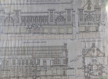 Federation University Historical Collection
Plan - Architectural Plans, Australian Natives' Association Ballarat Branch No 4 Architectural Plans
Percy Richards taught Architecture and Building Construction at The Ballarat Art School - a division of Ballarat School of Mines from 1918-1921. He was responsible for the design of a number of buildings in the district. This item is the "Specification of work required to be done and materiaals required for construction of the new A.N.A. Building at the corner of Sturt, Albert and Lewis Streets, Ballarat. Prepared by and to the satisfaction of P.S. Richards, A.R.V.I.A. Architect and subject to the General Conditions of Contract." "BALLARAT CITY A.N.A. BALLARAT, Wednesday — The Ballarat City branch, A.N.A., which was formed nearly 50 years ago, ranks fourth on the association records, but several of the members were prominent in establishing the association in Melbourne a year or two earlier. On the past half-year's operations the total funds increased by £1558/18/3 to £29.389/11/11. The membership now totals 949. The committee recommended that as the property at the corner of Sturt and Albert Streets, which had been intended as the site of a new hall, had been sold, steps should he taken to remodel the present hall, and bring It up to date. The report was adopted." (The Herald, 18 June 1924)Fourteen detailed drawings showing the specifications for each section of the new A.N.A. building for Ballarat. A 24 page document submitted to the Public Health Department, Victoria, received 15 January 1918 and a 3 page document related to Reinforced Concrete Particulars. All contained in a labelled black metal cylinder.A.N.A.4. PLANS painted on side and lid. Signature of P.S. Richards.ana, australian natives' association, architecture, percy richards, building specifications, ballarat, technical art school ballarat, materials, construction, p.s. richards, percival selwyn richards -
Whitehorse Historical Society Inc.
Document, Mitcham Repertory Group
Mitcham Repertory Group Miscellaneous papers;Miscellaneous papers; including constitution, list of members (1988), statement of purposes, plan of theatre; duty statements, productions (to 1994)Mitcham Repertory Group Miscellaneous papers;mitcham repertory group, grant, max -
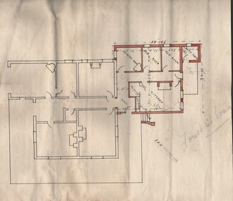 Bendigo Historical Society Inc.
Document - BUSH COLLECTION: PLAN OF HOUSE (FOREST ST, BENDIGO)
Plan of house (Forest St, Bendigo written in pencil on plan) showing what may be extension to original house (in colour and with dimensions). Possibly house of Merle Bush??. Stamp on front: E.?.V. Phone 942.person, individual, bush collection - personal, bendigo, bush collection, collection, house plan, drafting, drawing, plan, house, home -
Port Melbourne Historical & Preservation Society
Plan - Unnamed Street, c. 1893
Plan for "unnamed street" (later Edwards, Morley) Loan Works 1893, plan no. 11 engineering - roads streets lanes and footpaths -
University of Melbourne, Burnley Campus Archives
Plan - Photocopy, Proposed Reserve for Horticultural and Experimental Garden in the Survey Paddock Richmond, 1862-1948
Photocopy of Plan Gazetted 01.08.1863. From Central Plan Office Department of Natural Resources.Signed by Clement Hodgkinson, Deputy Surveyor General. Stamped Department of Lands and Survey 7.12.48 Neg.18377. Handwritten notes on it, "Melb Roll 23 R.19(A)"exprimental gardens, burnley -
Whitehorse Historical Society Inc.
Document, Former Standard Brickworks, Box Hill, 2001
Documents relating to history, conservation and use of the former Standard Brickworks, Box Hill.Documents relating to history, conservation and use of the former Standard Brickworks, Box Hill. Conservation and Management Plan and Sort term Maintenance Plan prepared for Phileo Australia by Bryce Rawarth Pty Ltd, April 2001. Heritage Victoria Permit Application submitted on behalf of The Evangelical Community Church, by Adam Lovell & Associates Pty Ltd, December 2001.Documents relating to history, conservation and use of the former Standard Brickworks, Box Hill. standard brick company, allom lovell & associates, bryce rawarth pty ltd, phileo australia ltd, heritage victoria -
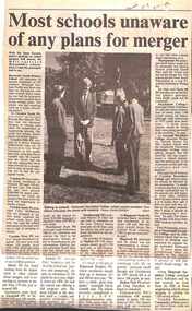 Ringwood and District Historical Society
Newspaper, Scrapbook Clipping, Library Collection, Ringwood, Victoria, `
``Newspaper clipping from the "Mail" 5-11-96 P9. Most schools unaware of any plans for merger.Wih the State Government's position well known on school mergers, "The Mail" surveyed Maroondah's schools on the same subject. Most of the surveyed schools said they knew nothing of any planned mergers, or they did not wish to comment. No school said they were in favour of mergers in Maroondah. ` -
Port Melbourne Historical & Preservation Society
Plan - Floor Plans, Proposed Port Melbourne Library, Fred Cook, City Engineer, 1938
From set of plans for the proposed Library - City of Port Melbourne 1938 4 sheets with ground floor plan, roof plan, 1st floor plan, side elevation, elevation. Two on paper, hand coloured; two on tracing paper."City of Port Melbourne Proposed Library":Fred Cook City Engineerbuilt environment - civic, city engineers, fred cook, port melbourne library -
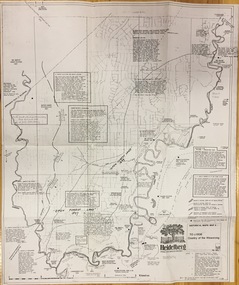 Kew Historical Society Inc
Plan, Loder & Bayly, Heidelberg: Historic River Landscape Assessment, 1982
Gwen McWilliam is well known as an authority on the history of Boroondara and the author of a large number of books and pamphlets about the City. She was awarded the medal of the Order of Australia in 2001 ‘for service to the community of Hawthorn and district, particularly through the research, documentation and publication of its history.’ This map from her collection was donated to the Kew Historical SocietyPlan of Heidelberg, annotated with details about the occupancy pre and post European settlement. The plan also contains geological references. The plan is included and analysed in volume 2 of the Heidelberg Conservation Study (1985). The original plan was published created in 1982. Printed annotationscity of heidelberg, yarra valley, historic plans -- heidelberg -
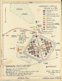 Tatura Irrigation & Wartime Camps Museum
Map - Sketch Plan, Internment Camp 3 Tatura as in 1945, January 1992
Plan drawn from documents and memory by former internees Helmut Ruff and Manfred Haering. Sketch plan of Camp 3 Tatura layout as in 1945. Camp contained members of Palestine, Singapore/Straits Settlement & New Guinea Groups.Copy of black ink and coloured A3 plan mounted on hardboard showing layout of buildings and perimeter fencing of camp 3 Tatura. Original hand drawn.palestine group, singapore group, new guinea group, helmut ruff, manfred haering, camp 3 layout -
Whitehorse Historical Society Inc.
Map, Gill's Springfield Road Estate, 1950?
Plan of subdivision for Gill's Springfield Road Estate, former orchard, 16 lots.Plan of subdivision for Gill's Springfield Road Estate, former orchard, 16 lots. Reprinted by Real Estate Agent, Spencer Jackson.Plan of subdivision for Gill's Springfield Road Estate, former orchard, 16 lots. land subdivision, norway avenue, blackburn, springfield road, blackburn, beverley crescent, blackburn, kevin avenue, blackburn, kerr street, blackburn, bordeaux avenue, blackburn, gill's estate, orchards, spencer jackson -
 Federation University Historical Collection
Plan - Plans, Ballarat School of Mines Albert Street Buildings, 1979
The Trade Workshops became known as the M.B. John Building, and later housed Ballarat Tech.Eight printed plans with coloured shading of SMB Albert St buildings: .1) Locality Plan .2) Trade Workshop Site Plan .3) Trade Workshop Floor Plan Level A & B .4) Trade Workshop Floor Plan Level C .5) Trade Workshop Floor Plan Level D .6) Trade Workshop Floor Plan Level E .7) Trade Workshop West Elevation and Sections .8) Trade Workshop North Elevations and Sections building plans, smb trade workshops, ewan jones and associates pty ltd, architectural plan, m.b. john building, albert street -
 Kew Historical Society Inc
Plan - Subdivision Plan, 10 Fine Villa Sites: Ermington Estate, Kew Heights, ca. 1917
Pru Sanderson, in her groundbreaking ‘City of Kew Urban Conservation Study : Volume 2 - Development History’ (1988), summarised the periods of urban development and subdivisions of land in Kew. The periods that she identified included 1845-1880, 1880-1893, 1893-1921, 1921-1933, 1933-1943, and Post-War Development. These periods were selected as they represented periods of rapid growth or decline in urban development. An obvious starting point for Sanderson’s groupings involved population growth and the associated economic cycles. These cycles also highlighted urban expansion onto land that was predominantly rural, although in other cases it represented the decline and breakup of large estates. A number of the plans in the Kew Historical Society’s collection can also be found in other collections, such as those of the State Library of Victoria and the Boroondara Library Service. A number are however unique to the collection.The Kew Historical Society collection includes almost 100 subdivision plans pertaining to suburbs of the City of Melbourne. Most of these are of Kew, Kew East or Studley Park, although a smaller number are plans of Camberwell, Deepdene, Balwyn and Hawthorn. It is believed that the majority of the plans were gifted to the Society by persons connected with the real estate firm - J. R. Mathers and McMillan, 136 Cotham Road, Kew. The Plans in the collection are rarely in pristine form, being working plans on which the agent would write notes and record lots sold and the prices of these. The subdivision plans are historically significant examples of the growth of urban Melbourne from the beginning of the 20th Century up until the 1980s. A number of the plans are double-sided and often include a photograph on the reverse. A number of the latter are by noted photographers such as J.E. Barnes.In November 1917, the Ermington Estate was advertised as an ‘Executor’s Sale’. It included the 10-roomed villa residence, ‘Ermington’, home of the late Mrs. Lorimer, and 10 ‘magnificent allotments’. The plan in the Kew Historical Society Collection is a little more specific. Ermington is described as having 9 Rooms &c. and there are 11 lots shown on the west side of Hillcrest Avenue. In the plan, the latter is named as ‘Hill Crest Avenue’. The plan indicates that the subdivision was based on the surveying work of Johnson & Tait. Opposite Ermington, the existing house ‘Parkhill’ is identified. A faded stamp on two parts of the plan indicates that it was in the possession of Jas. [R.] Mathers, Financial Agent, [136] Cotham Road, Kew.subdivision plans - kew, ermington heights estate - kew heights -
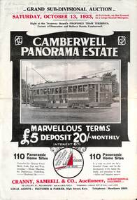 Melbourne Tram Museum
Ephemera - Real estate sale, Cranny Sambell & Co, "Camberwell Panorama Estate", Oct. 1923
Pamphlet advertising the sale of land at the "Camberwell Panorama Estate" - Doncaster and Bulleen Road 13-10-1923. Gives terms of sale, photos showing the views and a nearby shopping centre. Has a large photo of MMTB No. 20 on the front cover. The tramcar is of the Hawthorn Tramways Trust four-door bogie type. MMTB No 20 was an ex-Prahran and Malvern single trucker or small tram A class. Gives details of the 110 lots to be sold, terms, location, and that the tram was proposed to be extended to the corner. This extension took place in 1937. The locality plan shows proposed plans for tram lines in Belmore Road and Burke Road north of Whitehorse Road. Demonstrates the style of land sale pamphlet including the availability of tram services to prospective purchasers.Pamphlet - folded - printed in two colours of cream coloured paper with photographs and plans.has pencil notes on the top of the front page.sale of land, trams, real estate, camberwell panorama estate, east camberwell, doncaster road, bulleen road, tram 20 -
 Kew Historical Society Inc
Plan - Subdivision Plan, Mont Victor Hill Estate, 1936
Pru Sanderson, in her groundbreaking ‘City of Kew Urban Conservation Study : Volume 2 - Development History’ (1988), summarised the periods of urban development and subdivisions of land in Kew. The periods that she identified included 1845-1880, 1880-1893, 1893-1921, 1921-1933, 1933-1943, and Post-War Development. These periods were selected as they represented periods of rapid growth or decline in urban development. An obvious starting point for Sanderson’s groupings involved population growth and the associated economic cycles. These cycles also highlighted urban expansion onto land that was predominantly rural, although in other cases it represented the decline and breakup of large estates. A number of the plans in the Kew Historical Society’s collection can also be found in other collections, such as those of the State Library of Victoria and the Boroondara Library Service. A number are however unique to the collection.Subdivision plans are historically important documents used as evidence of the growth of suburbs in Australia. They frequently provide information about when the land was sold on which a built structure was subsequently constructed as well as evidence relating to surveyors and real estate and financial agents. The numerous subdivision plans in the Kew Historical Society's collection represent working documents, ranging from the initial sketches made in planning a subdivision to printed plans on which auctioneers or agents listed the prices for which individual lots were sold. In a number of cases, the reverse of a subdivision plan in the collection includes a photograph of a house that was also for sale by the agent. These photographs provide significant heritage information relating house design and decoration, fencing and household gardens.A preliminary plan for the Mont Victor Hill subdivision of 1936 which included 23 allotments bordering the Rimington Nursery in Mont Victor Road. The subdivision created allotments in Victor Avenue, Heather Grove and Burke Road. Bisecting the Estate and clearly marked on the plan is the Railway Reserve which at this stage was all that remained of the Outer Circle Railway. The auctioneers note on the plan that the subdivision was made possible by the order of Messrs S. H. Bennet & H. Wright, the executors of the Wills of S. Bennett & E. Foreman.mont victor hill estate, subdivision plans - kew -
Whitehorse Historical Society Inc.
Map, Parish of Boroondara and Parish of Nunawading, 1850
Photocopy of manuscript map.Photocopy of manuscript map. Note on verso: Plan of 22 portions marked in the Parish of Boroondara and 6 portions in the Parish of Nunawading c1850Photocopy of manuscript map. maps, parish of boroondara, parish of nunawading -
University of Melbourne, Burnley Campus Archives
Plan - Student Work, Grey Street Residence, December 2013
student work, assignment, landscape design -
University of Melbourne, Burnley Campus Archives
Booklet, Cloyne Nursery, A Book of Roses, c. 2011
roses, rose garden, plan, plant list -
Whitehorse Historical Society Inc.
Map, The Parish of Nunawading, 1853
Photocopy of manuscript plan with allotments numbered and some named.Photocopy of manuscript plan with allotments numbered and some named. Note on verso: The Parish of Nunawading in the County of Bourke; lithographed at the Surveyor General's office by J.Jones Jan 18th 1853. Endorsed Sale Plan 271. Dray tracks, water holes and terrain indicated.Photocopy of manuscript plan with allotments numbered and some named. land subdivision, maps, parish of nunawading, jones, j -
University of Melbourne, Burnley Campus Archives
Plan, Plans for Garden Bed, c. 1980
(1) Coloured elevation plan of plants. (2) Plan with key for Plant Name, Size and Colour.plants, gardens, flower beds