Showing 3922 items
matching 1890-1893
-
 Kew Historical Society Inc
Plan - Subdivision Plan, Rimington Nursery Estate, 1949
Pru Sanderson, in her groundbreaking ‘City of Kew Urban Conservation Study : Volume 2 - Development History’ (1988), summarised the periods of urban development and subdivisions of land in Kew. The periods that she identified included 1845-1880, 1880-1893, 1893-1921, 1921-1933, 1933-1943, and Post-War Development. These periods were selected as they represented periods of rapid growth or decline in urban development. An obvious starting point for Sanderson’s groupings involved population growth and the associated economic cycles. These cycles also highlighted urban expansion onto land that was predominantly rural, although in other cases it represented the decline and breakup of large estates. A number of the plans in the Kew Historical Society’s collection can also be found in other collections, such as those of the State Library of Victoria and the Boroondara Library Service. A number are however unique to the collection.The Kew Historical Society collection includes almost 100 subdivision plans pertaining to suburbs of the City of Melbourne. Most of these are of Kew, Kew East or Studley Park, although a smaller number are plans of Camberwell, Deepdene, Balwyn and Hawthorn. It is believed that the majority of the plans were gifted to the Society by persons connected with the real estate firm - J. R. Mathers and McMillan, 136 Cotham Road, Kew. The Plans in the collection are rarely in pristine form, being working plans on which the agent would write notes and record lots sold and the prices of these. The subdivision plans are historically significant examples of the growth of urban Melbourne from the beginning of the 20th Century up until the 1980s. A number of the plans are double-sided and often include a photograph on the reverse. A number of the latter are by noted photographers such as J.E. Barnes.The house lots in the Rimington Nursery Estate were advertised for sale on Saturday 22nd October 1949. The nine lots in the sale were in Stoke Avenue and Burke Road. Mathers & McMillan of 136 Cotham Road, Kew, offered the lots for sale. [The final sale of lots within the Rimington Nursery Estate occurred as late as 1958.]subdivision plans - kew, rimington nursery estate, monist victor road - kew (vic.) -
 Kew Historical Society Inc
Plan - Subdivision Plan, Erin Heights Estate, East kew, 1917
Pru Sanderson, in her groundbreaking ‘City of Kew Urban Conservation Study : Volume 2 - Development History’ (1988), summarised the periods of urban development and subdivisions of land in Kew. The periods that she identified included 1845-1880, 1880-1893, 1893-1921, 1921-1933, 1933-1943, and Post-War Development. These periods were selected as they represented periods of rapid growth or decline in urban development. An obvious starting point for Sanderson’s groupings involved population growth and the associated economic cycles. These cycles also highlighted urban expansion onto land that was predominantly rural, although in other cases it represented the decline and breakup of large estates. A number of the plans in the Kew Historical Society’s collection can also be found in other collections, such as those of the State Library of Victoria and the Boroondara Library Service. A number are however unique to the collection.The Kew Historical Society collection includes almost 100 subdivision plans pertaining to suburbs of the City of Melbourne. Most of these are of Kew, Kew East or Studley Park, although a smaller number are plans of Camberwell, Deepdene, Balwyn and Hawthorn. It is believed that the majority of the plans were gifted to the Society by persons connected with the real estate firm - J. R. Mathers and McMillan, 136 Cotham Road, Kew. The Plans in the collection are rarely in pristine form, being working plans on which the agent would write notes and record lots sold and the prices of these. The subdivision plans are historically significant examples of the growth of urban Melbourne from the beginning of the 20th Century up until the 1980s. A number of the plans are double-sided and often include a photograph on the reverse. A number of the latter are by noted photographers such as J.E. Barnes.The Erin Heights Estate in Kew included just seven lots in in Valerie Street. These were all that remained of this wartime subdivision, the other 11 allotments on Balfour and Belford Roads having already been sold. Balfour Road was to be only a temporary name as the street is currently called Windella Avenue. Now, the parkland opposite the subdivision is the reserve created from the route of the Outer Circle Railway. This Railway reached Kew East in 1925, but had been planned as far back as 1873. The development focuses on the benefits of living in Kew: being at the highest of Kew’s ‘suburbs’; being a good residential area; its rapid growth; and the proximity of the Kew East tram in High Street. In 1917, the electric tramline only extended to a terminus at the Harp of Erin hotel. The terminus is clearly represented on the plan.subdivision plans - east kew, erin heights estate -
 Kew Historical Society Inc
Plan - Subdivision Plan, J R Mathers & McMillan, Willsmere Park Estate, c.1940
Pru Sanderson, in her groundbreaking ‘City of Kew Urban Conservation Study : Volume 2 - Development History’ (1988), summarised the periods of urban development and subdivisions of land in Kew. The periods that she identified included 1845-1880, 1880-1893, 1893-1921, 1921-1933, 1933-1943, and Post-War Development. These periods were selected as they represented periods of rapid growth or decline in urban development. An obvious starting point for Sanderson’s groupings involved population growth and the associated economic cycles. These cycles also highlighted urban expansion onto land that was predominantly rural, although in other cases it represented the decline and breakup of large estates. A number of the plans in the Kew Historical Society’s collection can also be found in other collections, such as those of the State Library of Victoria and the Boroondara Library Service. A number are however unique to the collection.The Kew Historical Society collection includes almost 100 subdivision plans pertaining to suburbs of the City of Melbourne. Most of these are of Kew, Kew East or Studley Park, although a smaller number are plans of Camberwell, Deepdene, Balwyn and Hawthorn. It is believed that the majority of the plans were gifted to the Society by persons connected with the real estate firm - J. R. Mathers and McMillan, 136 Cotham Road, Kew. The Plans in the collection are rarely in pristine form, being working plans on which the agent would write notes and record lots sold and the prices of these. The subdivision plans are historically significant examples of the growth of urban Melbourne from the beginning of the 20th Century up until the 1980s. A number of the plans are double-sided and often include a photograph on the reverse. A number of the latter are by noted photographers such as J.E. Barnes. In 1910, the Willsmere Park Estate Dairy was lauded in the Box Hill Reporter as ‘an object lesson in dairying’. Ten years later, in 1923, it was to be sold. The first subdivision of the Estate included 77 grand allotments with frontages to Belford and Kilby Roads, Elm and Willow Groves, and Acacia Avenue. Every lot was claimed to be ‘high and dry’, and with panoramic views of Kew and East Kew. The balance of the Estate, and the largest proportion of allotments was to be subdivided and sold from 1940. This second sale included 109 lots fronting Kilby Road and Elm and Willow Groves. Annotations on the plan indicate that the more expensive lots faced Belford Road opposite the Kew Golf Links. Two of these sold for £310. Lots further to the west in Willow Grove were sold for £60 less. Many of the houses to be built on these 109 allotments after the War faced Government restrictions on building materials and the dimensions of each house due to postwar shortages.subdivision plans - east kew, willsmere park estate -
 Kew Historical Society Inc
Plan - Subdivision Plan, Jas R Mathers Son & McMillan, East Kew Tramway Estate, 1915
Pru Sanderson, in her groundbreaking ‘City of Kew Urban Conservation Study : Volume 2 - Development History’ (1988), summarised the periods of urban development and subdivisions of land in Kew. The periods that she identified included 1845-1880, 1880-1893, 1893-1921, 1921-1933, 1933-1943, and Post-War Development. These periods were selected as they represented periods of rapid growth or decline in urban development. An obvious starting point for Sanderson’s groupings involved population growth and the associated economic cycles. These cycles also highlighted urban expansion onto land that was predominantly rural, although in other cases it represented the decline and breakup of large estates. A number of the plans in the Kew Historical Society’s collection can also be found in other collections, such as those of the State Library of Victoria and the Boroondara Library Service. A number are however unique to the collection.The Kew Historical Society collection includes almost 100 subdivision plans pertaining to suburbs of the City of Melbourne. Most of these are of Kew, Kew East or Studley Park, although a smaller number are plans of Camberwell, Deepdene, Balwyn and Hawthorn. It is believed that the majority of the plans were gifted to the Society by persons connected with the real estate firm - J. R. Mathers and McMillan, 136 Cotham Road, Kew. The Plans in the collection are rarely in pristine form, being working plans on which the agent would write notes and record lots sold and the prices of these. The subdivision plans are historically significant examples of the growth of urban Melbourne from the beginning of the 20th Century up until the 1980s. A number of the plans are double-sided and often include a photograph on the reverse. A number of the latter are by noted photographers such as J.E. Barnes.The East Kew Tramway Estate was a subdivision of two separate parcels of land between Adeney Avenue and Normanby Road. The larger section included 54 lots facing Adeney Avenue, Argyle Road, and Campbell, Hunter and Wishart Streets. [Hunter and Wishart Streets were created as part of the subdivision.] A further 17 allotments faced Normanby Road, Hubert and Campbell Streets. [The name of Hubert Street was later to be changed to Cecil Street.] The promotion of the sale referred to the advantages of living between two tram routes, in High Street and Cotham Road. On the plan, quaintly drawn trams mark these routes. Also on the plan is the route of part of the Outer Circle [Railway] Line.east kew tramway estate, subdivision plans - east kew -
 Kew Historical Society Inc
Plan - Subdivision Plan, J R Mathers & McMillan, Clutha Subdivision, 1940
Pru Sanderson, in her groundbreaking ‘City of Kew Urban Conservation Study : Volume 2 - Development History’ (1988), summarised the periods of urban development and subdivisions of land in Kew. The periods that she identified included 1845-1880, 1880-1893, 1893-1921, 1921-1933, 1933-1943, and Post-War Development. These periods were selected as they represented periods of rapid growth or decline in urban development. An obvious starting point for Sanderson’s groupings involved population growth and the associated economic cycles. These cycles also highlighted urban expansion onto land that was predominantly rural, although in other cases it represented the decline and breakup of large estates. A number of the plans in the Kew Historical Society’s collection can also be found in other collections, such as those of the State Library of Victoria and the Boroondara Library Service. A number are however unique to the collection.The Kew Historical Society collection includes almost 100 subdivision plans pertaining to suburbs of the City of Melbourne. Most of these are of Kew, Kew East or Studley Park, although a smaller number are plans of Camberwell, Deepdene, Balwyn and Hawthorn. It is believed that the majority of the plans were gifted to the Society by persons connected with the real estate firm - J. R. Mathers and McMillan, 136 Cotham Road, Kew. The Plans in the collection are rarely in pristine form, being working plans on which the agent would write notes and record lots sold and the prices of these. The subdivision plans are historically significant examples of the growth of urban Melbourne from the beginning of the 20th Century up until the 1980s. A number of the plans are double-sided and often include a photograph on the reverse. A number of the latter are by noted photographers such as J.E. Barnes.The subdivision plan for the Clutha Subdivision is one of the largest in the Society’s collection. The plan includes a map of the proposed allotments, photographic views to the north and south, and information about the kinds of buildings that could be constructed on the allotments. The subdivision was bounded by Studley Park Road, and Carson, Stevenson and Edgecombe Streets. Two new streets, Mackie Court and Younger Street were created as part of the subdivision. The subdivision took its name from ‘Clutha’, the home of John Carson, who was to become Mayor of Kew in 1863. A Report to the City of Boroondara outlined how: ‘The Clutha estate was progressively developed from 1940, with new houses under construction on the Studley Park Road, Carson and Edgecombe Street frontages by 1941. By 1943, directory listings were available for all addresses with the exception of Mackie Court. Building ceased after the government’s prohibition on civilian building was enforced from 1942, with little change in listings until the 1950s when the remainder of the subdivision was developed’."H"subdivisions - kew - studley park, clutha subdivision, studley park road -
 Kew Historical Society Inc
Plan - Subdivision Plan, Jas R Mathers Son & McMillan, Macartney Estate, East Kew, c. 1925
Pru Sanderson, in her groundbreaking ‘City of Kew Urban Conservation Study : Volume 2 - Development History’ (1988), summarised the periods of urban development and subdivisions of land in Kew. The periods that she identified included 1845-1880, 1880-1893, 1893-1921, 1921-1933, 1933-1943, and Post-War Development. These periods were selected as they represented periods of rapid growth or decline in urban development. An obvious starting point for Sanderson’s groupings involved population growth and the associated economic cycles. These cycles also highlighted urban expansion onto land that was predominantly rural, although in other cases it represented the decline and breakup of large estates. A number of the plans in the Kew Historical Society’s collection can also be found in other collections, such as those of the State Library of Victoria and the Boroondara Library Service. A number are however unique to the collection.Subdivision plans are historically important documents used as evidence of the growth of suburbs in Australia. They frequently provide information about when the land was sold on which a built structure was subsequently constructed as well as evidence relating to surveyors and real estate and financial agents. The numerous subdivision plans in the Kew Historical Society's collection represent working documents, ranging from the initial sketches made in planning a subdivision to printed plans on which auctioneers or agents listed the prices for which individual lots were sold. In a number of cases, the reverse of a subdivision plan in the collection includes a photograph of a house that was also for sale by the agent. These photographs provide significant heritage information relating house design and decoration, fencing and household gardens.The Macartney Estate subdivision advertised 21 lots for sale on either side of Macartney Street (now Macartney Avenue) and Evans Road in what was then designated as East Kew. Most of the houses shown on the south side of Macartney Street then, as now, have rear entrances on Mount Street, however a number of these blocks have since been further subdivided to allow for the building of new houses on the rear of a block. Brougham Place is marked on the plan but is now called Daniell Place."C"subdivision plans - east kew, macartney estate, macartney street, mount street, evans road, brougham place -
 Kew Historical Society Inc
Plan - Subdivision Plan, J R Mathers & McMillan, Glenarbor Estate, 1934
Pru Sanderson, in her groundbreaking ‘City of Kew Urban Conservation Study : Volume 2 - Development History’ (1988), summarised the periods of urban development and subdivisions of land in Kew. The periods that she identified included 1845-1880, 1880-1893, 1893-1921, 1921-1933, 1933-1943, and Post-War Development. These periods were selected as they represented periods of rapid growth or decline in urban development. An obvious starting point for Sanderson’s groupings involved population growth and the associated economic cycles. These cycles also highlighted urban expansion onto land that was predominantly rural, although in other cases it represented the decline and breakup of large estates. A number of the plans in the Kew Historical Society’s collection can also be found in other collections, such as those of the State Library of Victoria and the Boroondara Library Service. A number are however unique to the collection.The Kew Historical Society collection includes almost 100 subdivision plans pertaining to suburbs of the City of Melbourne. Most of these are of Kew, Kew East or Studley Park, although a smaller number are plans of Camberwell, Deepdene, Balwyn and Hawthorn. It is believed that the majority of the plans were gifted to the Society by persons connected with the real estate firm - J. R. Mathers and McMillan, 136 Cotham Road, Kew. The Plans in the collection are rarely in pristine form, being working plans on which the agent would write notes and record lots sold and the prices of these. The subdivision plans are historically significant examples of the growth of urban Melbourne from the beginning of the 20th Century up until the 1980s. A number of the plans are double-sided and often include a photograph on the reverse. A number of the latter are by noted photographers such as J.E. Barnes.The little-known Glenarbor Estate comprised 23 allotments bordering Wellington and Denmark Streets and Fenton Avenue. The auction of the allotments in the Estate was held in the Kew Recreation Hall. The purported advantages to Kew are identified on the plan, such as the close proximity of the entrance to the Kew Railway Station and access to shops in Denmark Street. Due to its location, the subdivision was pitched at commercial as well as residential purchasers. The Estate was to cause a crisis in the Kew Council as a majority of councillors voted on 29 May to acquire the entire Estate as the location of a new Town Hall. The Estate was said to be valued at £50,000. A later meeting was to rescind the vote, instead opting for the compulsory acquisition of South Esk on the corner of Charles Street and Cotham Road. That acquisition was to be overturned by the State Government. The debate about the purchase of the Glenarbor Estate by Council coincided with the decision to widen High Street on the South side between Cotham Road and the Junction."D"subdivision plans - kew, glenarbor estate, wellington street, denmark street -
 Kew Historical Society Inc
Plan - Subdivision Plan, Jas R Mathers Son & McMillan, The Dale Estate, Deepdene, 1918
Pru Sanderson, in her groundbreaking ‘City of Kew Urban Conservation Study : Volume 2 - Development History’ (1988), summarised the periods of urban development and subdivisions of land in Kew. The periods that she identified included 1845-1880, 1880-1893, 1893-1921, 1921-1933, 1933-1943, and Post-War Development. These periods were selected as they represented periods of rapid growth or decline in urban development. An obvious starting point for Sanderson’s groupings involved population growth and the associated economic cycles. These cycles also highlighted urban expansion onto land that was predominantly rural, although in other cases it represented the decline and breakup of large estates. A number of the plans in the Kew Historical Society’s collection can also be found in other collections, such as those of the State Library of Victoria and the Boroondara Library Service. A number are however unique to the collection.The Kew Historical Society collection includes almost 100 subdivision plans pertaining to suburbs of the City of Melbourne. Most of these are of Kew, Kew East or Studley Park, although a smaller number are plans of Camberwell, Deepdene, Balwyn and Hawthorn. It is believed that the majority of the plans were gifted to the Society by persons connected with the real estate firm - J. R. Mathers and McMillan, 136 Cotham Road, Kew. The Plans in the collection are rarely in pristine form, being working plans on which the agent would write notes and record lots sold and the prices of these. The subdivision plans are historically significant examples of the growth of urban Melbourne from the beginning of the 20th Century up until the 1980s. A number of the plans are double-sided and often include a photograph on the reverse. A number of the latter are by noted photographers such as J.E. Barnes.The Dale Estate in Deepdene was made possible by the death of Robert Sparrow Smythe, Australian journalist, newspaper editor/owner and theatrical manager. Smythe lived in his residence ‘Highate’, Deepdene until his death in 1917. In the subdivision proposed one year later, before the end of the First World War, 18 allotments were to be created. The very fragmentary plan in the Society’s collection notes that a large weatherboard [house] will need to be removed. This may be Smythe’s own home. The proposed subdivision included allotments facing Burke and Whitehorse Roads and Dale Street. Bordering the subdivision is the Deepdene Station and the Outer Circle Railway Line. The clear directions on the plan indicate that in 1918 it was possible to travel by train from Deepdene to East Camberwell and Ashburtonsubdivision plans - deepdene, the dale estate -
 Kew Historical Society Inc
Plan - Subdivision Plan, Jas R Mathers Son & McMillan, Clifton Estate, Kew, c. 1916
Pru Sanderson, in her groundbreaking ‘City of Kew Urban Conservation Study : Volume 2 - Development History’ (1988), summarised the periods of urban development and subdivisions of land in Kew. The periods that she identified included 1845-1880, 1880-1893, 1893-1921, 1921-1933, 1933-1943, and Post-War Development. These periods were selected as they represented periods of rapid growth or decline in urban development. An obvious starting point for Sanderson’s groupings involved population growth and the associated economic cycles. These cycles also highlighted urban expansion onto land that was predominantly rural, although in other cases it represented the decline and breakup of large estates. A number of the plans in the Kew Historical Society’s collection can also be found in other collections, such as those of the State Library of Victoria and the Boroondara Library Service. A number are however unique to the collection.The Kew Historical Society collection includes almost 100 subdivision plans pertaining to suburbs of the City of Melbourne. Most of these are of Kew, Kew East or Studley Park, although a smaller number are plans of Camberwell, Deepdene, Balwyn and Hawthorn. It is believed that the majority of the plans were gifted to the Society by persons connected with the real estate firm - J. R. Mathers and McMillan, 136 Cotham Road, Kew. The Plans in the collection are rarely in pristine form, being working plans on which the agent would write notes and record lots sold and the prices of these. The subdivision plans are historically significant examples of the growth of urban Melbourne from the beginning of the 20th Century up until the 1980s. A number of the plans are double-sided and often include a photograph on the reverse. A number of the latter are by noted photographers such as J.E. Barnes.The Clifton Estate was an ambitious subdivision. It included 61 allotments bordering Cotham and Park Hill Roads, and Florence and Adeney Avenues. It is difficult to ascertain the exact year when the ‘Clifton Estate’ was surveyed, subdivided and first auctioned. The uncertainty may be due to allotments being released during the First World War. The subdivision took its name from the house ‘Clifton’ (lot 5) on the corner of Adeney Avenue and Cotham Road. The outline of Clifton (since demolished) and the extent of its land following the subdivision are represented on the plan. The auctioneers have also shown ‘Maryfield’ and ‘Wimba’, the neighbouring properties in Cotham Road, on the plan."B"subdivision plans - kew, clifton estate, cotham road, adeney avenue, florence avenue, park hill road -
 Kew Historical Society Inc
Plan - Subdivision Plan, Plan of Subdivision of Part of Crown Portion 84 / Parish of Boroondara / County of Bourke / Lodged Plan No. 2217, Twentieth Century
Pru Sanderson, in her groundbreaking ‘City of Kew Urban Conservation Study : Volume 2 - Development History’ (1988), summarised the periods of urban development and subdivisions of land in Kew. The periods that she identified included 1845-1880, 1880-1893, 1893-1921, 1921-1933, 1933-1943, and Post-War Development. These periods were selected as they represented periods of rapid growth or decline in urban development. An obvious starting point for Sanderson’s groupings involved population growth and the associated economic cycles. These cycles also highlighted urban expansion onto land that was predominantly rural, although in other cases it represented the decline and breakup of large estates. A number of the plans in the Kew Historical Society’s collection can also be found in other collections, such as those of the State Library of Victoria and the Boroondara Library Service. A number are however unique to the collection.The Kew Historical Society collection includes almost 100 subdivision plans pertaining to suburbs of the City of Melbourne. Most of these are of Kew, Kew East or Studley Park, although a smaller number are plans of Camberwell, Deepdene, Balwyn and Hawthorn. It is believed that the majority of the plans were gifted to the Society by persons connected with the real estate firm - J. R. Mathers and McMillan, 136 Cotham Road, Kew. The Plans in the collection are rarely in pristine form, being working plans on which the agent would write notes and record lots sold and the prices of these. The subdivision plans are historically significant examples of the growth of urban Melbourne from the beginning of the 20th Century up until the 1980s. A number of the plans are double-sided and often include a photograph on the reverse. A number of the latter are by noted photographers such as J.E. Barnes.Undated Plan of Subdivision of Crown Portion 84 in what is now Kew. The area shown is bordered by Burke Road, Harp Road, Arglye Road and Normanby Road.subdivision plans -- kew (vic), harp road, burke road, normanby road, lady loch's drive, gladstone street, second avenue, first avenue -
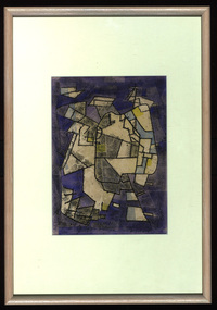 Federation University Art Collection
Work on paper - Artwork - Printmaking, 'Untitled', by Ludwig Hirshfeld-Mack, 1959
Ludwig HIRSCHFELD-MACK (1893-1965) Born 11 July 1893, Frankfurt am Main, Germany In 1940 Hirschfeld-Mack was deported to Australia from England as an enemy alien in the Dunera. He was interned at Hay and Orange, New South Wales, and at Tatura, Victoria. There he made a number of woodcuts that illustrated life under detention. Released in 1942 through the sponsorship of (Sir) James Darling, headmaster of Geelong Church of England Grammar School, Hirschfeld-Mack was appointed its art master. He promoted his pupils' self-knowledge, introduced them to avant-garde painting techniques, and encouraged wood-carving, weaving, musical instrument-making, leatherwork and other crafts. (http://adb.anu.edu.au/biography/hirschfeld-mack-ludwig-10510, accessed 29 June 2016) He died on 7 January 1965 at Allambie Heights, Sydney Framed abstract paintingSigned in pencil lower left hand side 'L.H.Mack 1959'art, artists, mack, hirschfeld-mack, ludwig hirschfeld-mack, ludwig hirshfeld-mack, printmaking, monoprint, bauhaus -
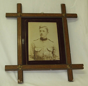 Stratford and District Historical Society
Photograph, Framed
The photograph that appears in this frame is a copy. The original is catalogued at 01314. Sgt David Hamilton Pruden, 404, enlisted from Newry and was killed at Koster River in the Trasnvaal on 21 July 1900, and was buried at Rustenburg cemetery. He is commemorated in a large tablet in the Stratford Mechanics' Institute. This photograph originally hung in the Stratford Mechanics' Institute. A framed sepia copy photographic print of a head and shoulders portrait of a young man in dress uniform of the Victorian Mounted Rifles, labelled Pte D.Pruden and presumed to be David Hamilton Pruden, who died in Africa during the Boer War. The frame, of crossed wooden bars with decorative metal at each crossing, appears to be commercially produced. Backing support for the frame is a section of an 1893 calender for an unknown insurance firm, agent J.B Kelly at Stratford, which has been detached for separate cataloguing.boer war 1899-1902 -
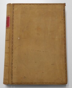 Bendigo Historical Society Inc.
Document - LANDS OFFICE: CERTIFIED PLAN REGISTER
Document: hard cover journal. Buff cover with embossed edges. Spine has red insert with 'Certified Plan Register' printed in gold. 250 pages, with index in front of register. LH page: number, date of receipt, name, parish, tracing book, plan, decision of Board of land and works, gazette page, name of surveyors, date of survey, sent to, date. RH page: précis of minute. Dated 1878 - 1893, includes areas in central and northern Victoria.plan register, lands office, bendigo, plans, surveyed, victoria, northern victoria -
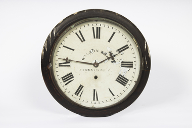 Warrnambool and District Historical Society Inc.
Functional object - Railway Clock, Wilson Brothers, Clock Makers, Warrnambool, 1890s
This clock is believed to have come from the Warrnambool Railway Station. The Railway commenced in 1890 and the station was opened in 1897. The clock was made by Wilson Brothers, a prominent manufacturing watch and clock- making business in Timor Street, Warrnambool in the second half of the 19th Century.This item is of considerable significance as an early Railway Clock in Warrnambool. Railway Clocks were important in the 19th century as prominent time pieces for the general community to use to establish the time of day.This is a clock with a circular face behind glass enclosed in a metal frame with wood surrounds The wooden frame is attached to a wooden rectangular box with a curved bottom. The box has a metal clip for attachment to a wall or a board. The metal face is white with black painted Roman numerals, which are damaged, and black printing. Minute markers are indicated. The hands are metal. All the metal is rusted.Wilson Bros Warrnamboolwarrnambool railway station, wilson brothers warrnambool -
 Ararat & District Historical Society (operating the Langi Morgala Museum)
Tool - Nurses Lamp
The lamp helps contextualise the nursing history of our region. This item was owned by Sister Hebe Graham, who was born in 1890 and trained at Stawell Hospital before WW1. She became a specialist nurse and received a commendation from Lord Duggan, Governor of Victoria.Flat, rectangular lamp with light fixed at top centre and activated by small spring-loaded button on top of lamp. Case is primarily stainless steel and partially covered in a leather case."T E C BRITISH MADE" stamped on top of lamp.sister hebe graham, nurses lamp, stawell hospital, ww1, 1890, lord duggan -
 Emerald Museum & Nobelius Heritage Park
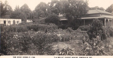
Photograph/postcard, 'La Belle' Guest House, Emerald, Vic, c 1940's
Tim Kennedy built 'La Belle' Guest House circa 1890 - 1920. It became 'The Grange' sometime after 1942. The guest house was on Belgrave/Gembrook Road between IGA and the Shell Petrol Station. Unfortunately the guest house was demolished around 1983.Guest houses of the DandenongsSepia postcard, Rose Series depicting early guest house in EmeraldFront: The Rose Series Postcard, 'La Belle' Guest House, Emerald Vic. Back:: (handwritten) Dear Miss Hartnell, Just to wish you a Happy Xmas and bright new year I hope and trust that your health is better it was just twelve months yesterday since I returned from Olinda how time flies Doesent it, with all good wishes yours sincerely B George'la belle', the grange, tim kennedy -
 Uniting Church Archives - Synod of Victoria
Illuminated Testimonial, Rev W Hewiston, 1895
Presented to Rev Hewiston on his departure from Brunswick Presbyterian Church to the John Knox Church Dunedin New Zealand. Rev W Hewiston BA 1890 ordained Brunswick, assistant to A MacVean (McVean); 1895 Dunedin New Zealand, Knox ChurchBrown leather cover with heavily decorative gilt embossed border and text. The inside left has a richly illuminated border round the text which is addressed to the Rev & Mrs Hewiston. It is decorated with a variety of colourful flowers and an image of the Brunswick Presbyterian Church. The right side is a continuation of the testamonial from the Brunswick Presbyterian Church congregation. It is signed by the Acting Session Clerk Evander McIver; Treasurer Daniel Tough and Secretary Daniel McDougall.brunswick presbyterian church, daniel tough, rev w hewiston, rev allan macvean, john knox church dunedin new zealand, daniel mcdougall -
 National Wool Museum
Wool Press
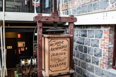
Built by Humble & Nicholson at the Vulcan Foundry, Geelong, press no. 804. Was sold to the Shanahans of Happy Valley, Birregurra on 18/10/1890 and remained on the property until the late 1960s/early 1970s when it was donated to the Geelong Agricultural society who donated in to the Museum.humble and nicholson, wool press, happy valley, birregurra, vic. -
 Kew Historical Society Inc
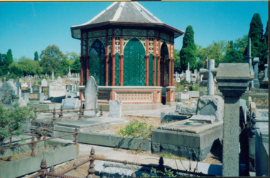
Photograph - Rotunda, Boroondara General (Kew) Cemetery
Architect and surveyor, Albert Purchas, is believed to be the designer of the cast iron entrance gates (1889), the rotunda (1890) and the surrounding ornamental brick wall (1895–6), as well as various additions to the original 1860 Cottage in the period 1866–1899 including the clock tower.Colour print positive photograph of the restored rotunda, surrounded by graves in the Boroondara (Kew) Cemetery.Nil -
 Bendigo Historical Society Inc.
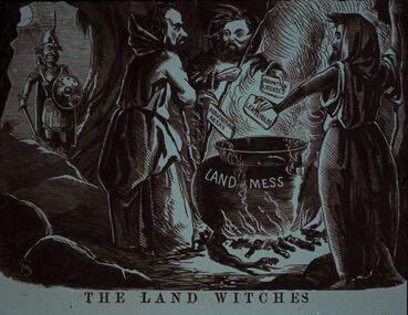
Slide - DIGGERS & MINING. LIFE OF THE SELECTORS, c1860
Diggers & Mining. Life Of The Selectors. Diggers & Mining. A soldier looks on as three male witches stand around a cauldron placing cards in the pot with OCCUPATION LICENSES, LEASE HOLDS and AGRICULTURAL AREAS written on them, the cauldron is labelled LAND MESS. The title of the picture is 'The Land Witches'. Markings; Life Of The Selectors 1860-1890 Set 432 No. 16. The Land Witches ''Melbourne Punch,'' Feb 25, 1864. Used as a teaching aid.Visual Eduation Centreeducation, tertiary, goldfields -
 Bendigo Historical Society Inc.
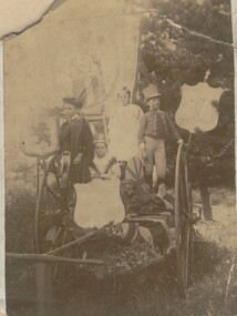
Photograph - EASTER FAIR, JUVENILE FIRE BRIGADE, c1890's
Sepia photograph of group of children. Two girls, two boys on hand card. Four shields and banner decoration. Lion statue on right front. One boy in Scottish dress. One with top hat with feather. Girls with coronets. On back - 'Easter Procession Exhibit, 1890's +, probably Juvenile Fire Brigade' . On back - 3cls, p8, A feast', 'Royal Historical Society of Victoria, Bendigo Branch' circular stamp.person, group, easter procession -
 Bendigo Historical Society Inc.
Document - ANTON MEURER
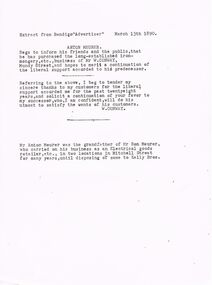
Typed extract from The Bendigo Advertiser dated March 13th 1890. Article mentions Anton Meurer has purchased the ironmongery business of Mr W Conway. Also a short note from W. Conway thanking his customers for their support and his confidence in the new owner satisfying the wants of his customers. Mr Anton Meurer was the grandfather of Mr Ron Meurer who had an electrical goods store.document, names of bendigo pioneers, bendigo advertiser, anton meurer, bendigo advertiser 13/3/1890, mr w conway, mr ron meurer, kelly bros. -
 Whitehorse Historical Society Inc.
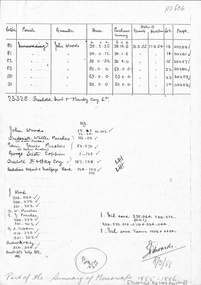
Document, Nunawading, ?1995
Photocopy of search notes summarising memorials relating to part Crown Portions 80,81,82,89,90 and 91 originally granted to John Woods, 31 March 1855 and transferred to Frederick Walter Purches, Edwin James Purches, George Seth Coppin, Freehold Investment and Banking Co of Australia and Australian Deposit and Mortgage Bank; with page listing titles derived from Freehold Investment and Banking Co of Australia Limited 1889 - 1890.non-fictionmorton thomas richards burrowes -
 Tatura Irrigation & Wartime Camps Museum
Safe, Coolgardie, pre 1945
Coolgardie safes were first used on Western Australian gold fields, approx 1890's. Soon became universally used in Australia until ice chests took over about 1940. Some stood 2 meter high by 1 meter square.Frame with hessian attached on all sides. Galvanized iron tray on top holding water which is siphoned down to keep hessian wet. Breeze passing through wet hessian cools contents on shelves inside.coolgardie safes -
 Stawell Historical Society Inc
Book, Richard Morcom, Exercise Book Chemistry Essaying Schoolwork, 1895-1899
These books belonged to Goldsworthy R.M. Stawell when a student of School of mines. 1 book contains information Re Chemistry, Assaying etc. Other book contains working hours - Not at Stawell - Notes taken from food in health and Disease by Burney J 1890Exercise book - contains school work.Richard Morcom Goldsworthy School of Mines Skene Street Stawellstawell education -
 National Wool Museum
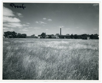
Photograph
Exterior view of the Barwon Mill (built 1874; taken over by Godfrey Hirst and renamed Excelsior One in 1890) in 1966. In 1966 McKendrick Consolidated Industries Ltd purchased Godfrey Hirst Ltd to operate a carpet manufacturing concern and this photo was taken at the time of the takeover.Proof IAN HAWTHORNE / PHOTOGRAPHER / Commercial, Portrait, Wedding, Colour Processor / Upstairs, 140 Moorabool St., Geelong Ph. 98096textile mills, godfrey hirst and co. pty ltd, barwon woollen mill, excelsior one mill -
 Stawell Historical Society Inc
Book, Richard Morcom, Exercise Book, Wages, Loads of Materials for Crushing Plants Firewood etc, 1895-1899
These books belonged to Goldsworthy R.W. Stawell when a Student at School of Mines - 1 Book contains information re chemistry assaying ect. Other book contains working hours - Not at Stawell- Notes taken from Food in Health and Disease by Burney J. 1890641-1 Conatins Miscellaneous material. Re Wages - Loads of material for crushing Plants, firewood, etcRichard Morcom Goldsworthy School of Mines Skene Street Stawellstawell education -
 Bendigo Historical Society Inc.
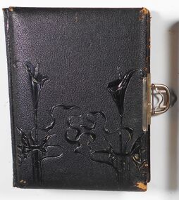
Leisure object - Photo Album
Richard Hartley Smith Abbott and Mary Hannah Gibbs had eight children. This family albums contained photos of them and two of their children - Harold Athelstane Abbott (Born 1889. Died 1979) and Kenneth Cyril Abbott (Born 1890). Photos catalogued individually.A dark brown leather-bound photograph album belonging to the family of Richard Hartley Smith Abbott. The front cover has decorative embossed floral patterns, the back cover has an embossed geometric pattern. Inside the covers is a green and gold floral-patterned paper lining. Twelve heavy card double sided pages have cut out sections with openings for insertion of photographs. Six of the pages have decorative borders of painted flowers. The pages have gold covered edges. The album has a silver metal clasp to secure the album. photo album, r h s abbott family -
 Bendigo Historical Society Inc.
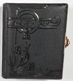
Leisure object - Photo Album
Richard Hartley Smith Abbott and Mary Hannah Gibbs had eight children. This family album contained photos of them and two of their children - Harold Athelstane Abbott (Born 1889. Died 1979) and Kenneth Cyril Abbott (Born 1890). Photos catalogued individually.A dark brown leather-bound photograph album belonging to the family of Richard Hartley Smith Abbott. The covers have decorative embossed geometric and floral patterns. Inside the covers is a brown floral-patterned paper lining. Fourteen heavy card double sided pages have cut out sections with openings for insertion of photographs. Seven of the pages have decorative borders of painted flowers. The pages have gold covered edges. The album has a silver metal clasp to secure the album. photo album, r h s abbott family -
 Royal Australian and New Zealand College of Obstetricians & Gynaecologists (RANZCOG)
Hewitt's cradle pessary associated with Dr Frank Forster, c. 1870 to 1930
The pessary was first made of hard rubber then later from vulcanite. A major manufacturer was Allen & Hanburys, London. They were made in six sizes. The pessary was used to support the uterus in cases of prolapse of the uterus or assisted the conditions of relaxation of the vagina and reduction of vaginal hernia. The designer of this pessary was William Morse Graily Hewitt (1828-1893), a British gynaecologist, obstetrician and physician. Vulcanite pessary. The pessary is loosely 'v' shaped, with a thicker section at top and two 'wings'.pessary, intrauterine device