Showing 2090 items
matching bendigo maps
-
 Bendigo Historical Society Inc.
Map - HUSTLER'S & CHRISTMAS LINES OF REEFS - PLAN OF LINES OF SECTION OF REEFS
... Bendigo Historical Society Inc. Bendigo Historical Society ...Underground Survey of Mines Bendigo. Plan of Cross Section Lines Shewing Connections with Trigonometrical Stations and Base Lines. 13/3/99 Signed ? Stirling. Places and mines mentioned Speciman Hill, Tambour Major, Lansell's 180, Victory and Pandora, Great Extended Hustler's, Windmill Hill on Victoria Reef. Next part of map is a Plan of Lines of Section between the Hustler's and Christmas Lines of Reefs. 8/3/99. Signed ?. Transverse Section. Shows Tambour Major Co., near the Christmas Line of Reef, Crosscuts and their depth, geological features and stone encountered. Then shows Thistle Line, Charshalton Line, Napoleon Line, Nell Gwynne Line, New Chum Line, Lansell's No 180 with levels, depths and geological features. Drawing is continued in three parts to fit on paper. Lansell's East Shaft with levels and depths, geological features and stone encountered. Sheepshead Line, Old Shaft, Garden Gully Line, Victory and Pabndora Co with crosscuts, depths, geological features and stone encountered. Paddy's Gully Line, Derby Line, Millers Line, Hustler's Line, Great Extended Hustler's Co with levels, depths, geological features and stone encountered. A note beside a Saddle Reef: 360,000 pounds paid in dividends from this reef. Average ounces per ton gold noted where found. Reference Table for stone and geological features. Datum Line 700 feet above Sea Level Unscannedmining, parish map, hustler's & christmas lines of reefs, plan of lines of section of reefs, ? stirling, specimen hill, tambour major, lansell's 180, victory & pandora, great extended hustler's, windmill hill, victoria reef, tambour major co, christmas line, hustler's line, thistle line, carshalton line, napoleon line, nell gwynne line, new chum line, lansell's no 180, lansell's east shaft, sheepshead line, old shaft, garden gully line, paddy's gully line, derby line, miller's line, hustler's line, great extended hustler's co -
 Bendigo Historical Society Inc.
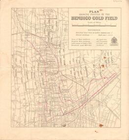
Map - BENDIGO GOLD FIELD - MAP OF PORTION OF THE BENDIGO GOLD FIELD
... BENDIGO GOLD FIELD - MAP OF PORTION OF THE BENDIGO GOLD... Gullies Mines Map showing portion of the Bendigo Gold Field ...Map showing portion of the Bendigo Gold Field showing Alluvial working, shaft sites , streets and lines of reefs.Department of Mines, Victoria. Many mines, lines of reefs and gullies are on the map. Blue Royal Historical Society of Victoria Bendigo Branch stamp on the back.document, bendigo gold field, department of mines, lines of reefs, gullies, mines -
Bendigo Historical Society Inc.
Document - HUSTLERS REEF - NOTES ON HUSTLERS REEF
... Bendigo Historical Society Inc. Bendigo Historical Society ...Notes written in red pen: Ref: B. M. L Hustlers Reef No 1 Page 269. Ironbark Co. 200'. 1857 -'64. (Latham & Watson's Trib. Working Party - see Eclipse Co 28 - 2 - 1865. 200' 1857 - 1859.mining, parish map, hustler's reef, hustlers reef, hustlers reef no 1, ironbark co., latham & watson's trib., eclipse co. -
Bendigo Historical Society Inc.
Map - GREAT EXTENDED HUSTLER'S MINE - LONGITUDINAL SECTION OF THE GREAT EXTENDED HUSTLER'S MINE
... Bendigo Historical Society Inc. Bendigo Historical Society ...Longitudinal Section of the Great Extended Hustler's Mine on the Hustler's Line of Reefs. Bulletin No 33, Plate No XIII. Map shows the Hustler's Tribute, 2 Old Shafts, Great Extended Hustler's Shaft, Latham & Watson's Shaft and Ironbark Gully. Datum Line 750 feet above Sea Level. Poppet Legs on the surface and Sill of Shaft 788.99 feet above Sea Level. Levels and their depths are shown and some geographical features. Some amounts of gold mined mentioned. Geological Survey of Victoria emblem and signed by H A Whitelaw, Underground Survey Office Bendigo, September 1913. Note - Plates 4, 8, 13,20, 26 & 31 form a Longitudinal Section from Fortuna Hustlers to Hustler's Consols Mine. This item has not been scanned or photographed.mining, parish map, great extended hustler's mine, longitudinal section of the great extended hustler's mine, geological survey of victoria, underground survey office bendigo, h a whitelaw, hustler's tribute, old shaft, great extended hustler's shaft, latham & watson's shaft, ironbark gully -
Bendigo Historical Society Inc.
Map - GREAT EXTENDED HUSTLER'S MINE - TRANSVERSE SECTION OF THE GREAT EXTENDED HUSTLER'S MINE
... Bendigo Historical Society Inc. Bendigo Historical Society ...Transverse Section of the Great Extended Hustler's Mine on the Hustler's Line of Reef. Bulletin No 33, Plate No XII. Shows Poppet legs at the surface and Sill of Shaft at 788.99 feet above Sea Level, Cross Cuts and their depths, stone and geographical features encountered and their references and a number of enlarged drawing of sections of the cross cuts, Geological Survey of Victoria emblem and signed by H A Whitelaw, Underground Survey Office Bendigo, September 1913. The depths of crosscuts to No 21 were taken from plans of surveys by Mr Walker and Mr Craven, noted under Reference. Another note: This Saddle Reef is sketched from Mr Walker's plan. Dividends amounting to 360,000 pounds were obtained from it. This item has not been scanned or photographed.mining, parish map, great extended hustler's mine, transverse section of the great extended hustler's mine, old shaft, mr walker, mr craven, geological survey of victoria, underground survey office bendigo, h a whitelaw -
 Bendigo Historical Society Inc.
Map - GREAT EXTENDED HUSTLER'S MINE - PLAN OF THE GREAT EXTENDED HUSTLER'S MINE
... Bendigo Historical Society Inc. Bendigo Historical Society ...Plan of the Great Extended Hustler's Mine. Bulletin No 33, Plate No XI. Shows No 2 Shaft, Latham & Watson's Shaft, levels and their depths and some geographical features. Geographical Survey of Victoria emblem and signed by H A Whitelaw, Underground Survey Office, Bendigo, September 1913. Has reference to photos.mining, parish map, great extended hustler's mine, no 2 shaft, latham & watson's shaft, geological survey of victoria, underground survey office bendigo, h a whitelaw -
 Bendigo Historical Society Inc.
Map - GREAT EXTENDED HUSTLER'S MINE - PLAN OF THE GREAT EXTENDED HUSTLER'S MINE
... Bendigo Historical Society Inc. Bendigo Historical Society ...Plan of the Great Extended Hustler's Mine on the Hustler's Line of Reefs, Bendigo. Bulletin No 33, Plate No X. Lease No 7382. Plan has map of streets. Mine was located in the block bounded by Langston and Anderson Streets and was between the Hustler's Anticline at Surface and the Lightning Hill Anticline at Surface. Latham & Watson's Shaft is also mentioned. Levels are numbered and a table shows the Levels and their Depths. Geological Survey of Victoria. Signed by H A Whitelaw, Underground Suyrvey Office, Bendigo, September 1913. This item has not been scanned or photographed.mining, parish map, great extended hustler's mine, hustler's line of reefs, mining lease no 7382, geological survey of victoria, underground survey office bendigo, h a whitelaw, latham & watson's shaft -
Bendigo Historical Society Inc.
Map - FORTUNA HUSTLER'S MINE - TRANSVERSE SECTION OF THE FORTUNA HUSTLER'S MINE
... Bendigo Historical Society Inc. Bendigo Historical Society ...Transverse Section of the Fortuna Hustler's Mine on the Hustler's Line of Reef, Bendigo. Bulletin No 33, Plate No III. Drawing shows poppet legs on the surface and Sill of Shaft 745.38 feet above Sea Level. Shows levels and their depths, geographical features and stone encountered. Reference table to stone and geographical features. Geographical Survey of Victoria emblem. Signed by H A Whitelaw, Underground Survey Office, Bendigo. This item has not been scanned or photographed.mining, parish map, fortuna hustler's mine, hustler's line of reef, geological survey of victoria, underground survey office bendigo, h a whitelaw -
 Bendigo Historical Society Inc.
Map - FORTUNA HUSTLER'S MINE - LONGITUDINAL SECTION OF THE FORTUNA HUSTLER'S MINE
... Bendigo Historical Society Inc. Bendigo Historical Society ...Longitudinal Section of the Fortuna Hustler's Mine on the Hustler's Line of Reef, Bendigo. Bulletin No 33, Plate No IV. Shows poppet legs at the surface level, Datum Line 750 feet above Sea Level, levels and their depths, the amount of gold per ton and some geographical features. Geological Survey of Victoria emblem and signed by H A Whitelaw, Underground Survey Office, Bendigo. Note - Plates 4, 8, 13, 20, 26 & 31 form a Longitudinal Section from Fortuna Hustler's to Hustler's Consols Mine. This item has not been scanned or photographed.mining, parish map, fortuna hustler's mine, longitudinal section of the fortuna hustler's mine, geological survey of victoria, h a whitelaw, underground survey office bendigo, hustler's line of reef, hustler's consols mine -
Bendigo Historical Society Inc.
Map - HUSTLER'S CONSOLS MINE - TRANSVERSE SECTION OF THE HUSTLER'S CONSOLS MINE
... Bendigo Historical Society Inc. Bendigo Historical Society ...Transverse Section of the Hustler's Consols Mine Bulletin No 33, Plate No XXXIII. Map shows poppet legs at the surface and Sill of Shaft 779.42 feet above Sea Level. Shows the different levels and their depths and the different stone and geographical features encountered. Has larger drawing of Section A - B. Geographical Survey of Victoria. Signed by H A Whitelaw, Underground Survey Office Bendigo, September 1913. This Item has not been scanned or Photographed.mining, parish map, hustler's consols mine, transverse section of the hustler's consols mine, geological survey of victoria, underground survey office bendigo, h a whitelaw -
Bendigo Historical Society Inc.
Map - HUSTLER'S REEF MINE - TRANSVERSE SECTION OF THE HUSTLER'S REEF MINE
... Bendigo Historical Society Inc. Bendigo Historical Society ...Transverse Section of the Hustler's Reef Mine on the Hustler's Line of Reefs. Bulletin No 33, Plate No XVIII. Shows cross-cuts and their depth, different types of stone and geological features encountered. Drawing of poppet legs at the surface and Sill of Shaft 756.39 ft above Sea Level. Reference Table shows key to the different stone and geographical features encountered. Geographical Survey of Victoria. Signed by H A Whitelaw, Underground Survey Office, Bendigo, September 1913. Thompson's Reef is also mentioned on the map. This item has not been scanned or photographed.mining, parish map, hustler's reef mine, transverse section of the hustler's reef mine, geological survey of victoria, h a whitelaw, underground survey office bendigo, thompson's reef. -
 Bendigo Historical Society Inc.
Map - HUSTLER'S REEF MINE - EAST & WEST CROSS-CUTS, NORTH & SOUTH OF SHAFT
... Bendigo Historical Society Inc. Bendigo Historical Society ...East & West Cross-cuts, North & South of Shaft, Hustler's Reef Mine Bulletin No 33, Plate No XIX. Map shows main shaft and smaller drawing of section with different stone encountered. Also gives location in relation to the shaft, e. g. 225'E & 150'S of Shaft. Reference diagram to show the different stone and features encountered. Geological Survey of Victoria emblem. Signed by H A Whitelaw, Underground Survey Office Bendigo, September 1913. This item has not been scanned or photographed.mining, parish map, hustler's reef mine, east & west cross-cuts north & south of shaft, geological survey of victoria, h a whitelaw, underground survey office bendigo -
Bendigo Historical Society Inc.
Map - HUSTLER'S REEF & HUSTLER'S REEF NO 1 MINES - LONGITUDINAL SECTION OF THE HUSTLER'S REEF & HUSTLER'S
... Bendigo Historical Society Inc. Bendigo Historical Society ...Longitudinal Section of the Hustler's Reef & Hustler's Reef No 1 Mines on the Hustler's Line of Reef. Bulletin No 33, Plate No XX. Note - Plates 4, 8, 13, 20, 26 & 31 form a Longitudinal Section from Fortuna Hustler's to Hustler's Consols Mine. Geological Survey of Victoria emblem. Signed by H A Whitelaw, Underground Survey Office Bendigo, September 1913. Shows the two shafts with their levels and depths. Also shows geographical features and yields of gold and amalgam per ton. This item has not been scanned or photographed.mining, parish map, hustler's reef & hustler's reef no 1 mines, longitudinal section of the hustler's reef & hustler's reef no 1 mines, geographical survey of victoria, underground survey office bendigo, h a whitelaw -
Bendigo Historical Society Inc.
Map - HUSTLER'S REEF & HUSTLER'S REEF NO 1 MINES - PLAN OF THE HUSTLER'S REEF & HUSTLER'S REEF NO 1 MINES
... Bendigo Historical Society Inc. Bendigo Historical Society ...Plan of the Hustler's Reef & Hustler's Reef No 1 Mines on the Hustler's Line of Reefs Bulletin No 33, Plate No XVII. Two drawings with different levels on each for clarity. Shows depth and some geographical features.Geological Survey of Victoria emblem. Signed by H A Whitelaw Underground Survey Office Bendigo, September 1913. This item has not been scanned or photographed.mining, parish map, hustler's reef & hustler's reef no 1 mines, plan of the hustler's reef & hustler's reef no 1 mines, hustler's line of reefs, geological survey of victoria, underground survey office bendigo, h a whitelaw -
Bendigo Historical Society Inc.
Map - HUSTLER'S REEF & HUSTLER'S REEF NO 1 MINES - PLAN OF THE HUSTLER'S REEF & HUSTLER'S REEF NO 1 MINES
... Bendigo Historical Society Inc. Bendigo Historical Society ...Plan of the Hustler's Reef & Hustler's Reef No 1 Mines on the Hustler's Line of Reefs, Bendigo Bulletin No 33, Plate No XIV. No 8 connecting No 10 (Hustler's Reef), No 11 connecting No 13 (Hustler's Reef), No 13 (Hustler's Reef No 1) connecting No 15 (Hustler's Reef) and No 10 Hustler's Reef No 1 rise to Comet Mine. Map shows different levels in relation to the two shafts, the lines of the Hustler's Line of Reefs and the Lightning Hill Line of Reefs, the approximate Boundary of Lease and the Comet Co., the adjoining lease. Table on the left shows the levels and their depths of the two mines. Signed by H A Whitelaw, Underground Survey Office, Bendigo, September 1913. Geological Survey of Victoria emblem. This item has not been scanned or photographed.mining, parish map, hustler's reef & hustler's reef no 1 mines, plan of the hustler's reef & hustler's reef no 1 mines, hustler's line of reefs lightning hill line of reefs, comet co., h a whitelaw, underground survey office bendigo, geological survey of victoria -
Bendigo Historical Society Inc.
Map - HUSTLER'S REEF & HUSTLER'S REEF NO 1 MINES - PLAN OF THE HUSTLER'S REEF & HUSTLER'S REEF NO 1 MINES
... Office, Bendigo. Geographical Survey of Victoria emblem. Map ...Plan of the Hustler's Reef & Hustler's Reef No 1 Mines on the Hustler's Line of Reefs, Bendigo Bulletin No 33, Plate No XVI. Plan shows the two shafts and the levels in relation to it. No 9 Level 896 feet 9 inches connecting No 10 Level at 867 feet 2 inches. Plan shows depth of levels and geographical features. Signed by H A Whitelaw, Underground Survey Office, Bendigo. Geographical Survey of Victoria emblem.mining, parish map, hustler's reef & hustler's reef no 1 mines, hustler's line of reefs, plan of the hustler's reef & hustler's reef no 1 mines, h a whitelaw, underground survey office bendigo, geographical survey of victoria, mining -
Bendigo Historical Society Inc.
Map - HUSTLER'S REEF & HUSTLER'S REEF NO 1 MINES - PLAN OF THE HUSTLER'S REEF & HUSTLER'S REEF NO 1 MINES
... Bendigo Historical Society Inc. Bendigo Historical Society ...Plan of the Hustler's Reef & Hustler's Reef No 1 Mines on the Hustler's Line of Reefs Bulletin No 33, Plate No XV. Plan shows the two mines with depth of levels, geological features and levels in relation to the shaft. Geological Survey of Victoria emblem and signed by H A Whitelaw, Underground Survey Office Bendigo, September 1913. Note - The Lease Boundaries shown on this plan are only in their approximate relative positions to Nos 13, Intermediate and 14 Levels of the Hustler's Reef No 1 workings, and Nos 15, 16 and 17 Levels of the Hustler's Reef workings.mining, parish map, hustler's reef & hustler's reef no 1 mines, plan of the hustler's reef & hustler's reef no 1 mines, geological survey of victoria, underground survey office bendigo, h a whitelaw, hustler's line of reefs -
 Bendigo Historical Society Inc.
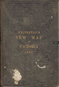
Book - WHITEHEAD'S NEW MAP OF VICTORIA 1869, 1869
... Bendigo Historical Society Inc. Bendigo Historical Society ...A brown/grey embossed book, with gold lettering titled 'Whitehead's New Map of Victoria 1869' containing a cloth bound map of Victoria, with coloured regions, with an alphabetical key of towns. Markings - ?(possibly J C) Bailey written on reverse of map in pen. In pencil inside book is marked 'W C'victoria, history, map -
Bendigo Historical Society Inc.
Document - HARRY BIGGS COLLECTION: MAP - BENDIGO
... HARRY BIGGS COLLECTION: MAP - BENDIGO.... Document HARRY BIGGS COLLECTION: MAP - BENDIGO ...Document. Harry Biggs Collection. A very rough hand drawn map of Pall Mall area taking in Police Court, Survey Office, Dudley House, Stockade, Fire Brigade, Camp & commissioners Gully.place, building, public buildings, harry biggs collection, map, bendigo -
 Bendigo Historical Society Inc.
Document - OLD TOM LEASE MAP
Hand Drawn map of Old Tom Lease - Parish of Huntly, County of Bendigo, Mining district of Sandhurst.place, land, mining -
Bendigo Historical Society Inc.
Map - RAYWOOD GOLD FIELD MAP, 1902
... Inc. History House 11 Mackenzie Street Bendigo goldfields MAP ...Map. Raywood Gold Field Map. Linen backed map of Raywood and Neilborough Township and surrounds showing the location of varying underground workings. Surveyed by H S Whitelaw 1/6/02. It shows underground workings from The Perseverance Party and moreshed and Party and underground workings on the Old Pioneer Reef. Mentions the Parish of Yallook, Parish of Neilborough, Yarraberb, Mushroom Flat, Murray Valley Plain, Eaglehawk and Kerang Railway, Green Hill, Doughboy, Redmond's Gully, Pickpocket Lead, Raywood Lead, Inglewood Lead, Shaw's Road, Nuggety Shaft, Barkly Shaft, Maori Bendmap, gold field map, raywood gold field map, neilborough, h s whitelaw, geological survey of victoria bulletin no 12 plate 11 -
 Bendigo Historical Society Inc.
Document - REPORT FROM THE SELECT COMMITTEE UPON THE CLAIMS OF HENRY FRENCHAM, 1890
( x ref 5673 , 8235 , Box 83 , 9077 ) Reports from the Gold Enquiry Select Committee from September 4th 1890 - 23rd October, including a list of witnesses, Minutes of Evidence 11th September 1890, 18th September 1890 and 25th September 1890; also, Appendices A - T, and also a location map drawn from memory by W. (William) Sandbach 18th Sep 1890 and Lithographed at the Department of Lands and Survey Melbourne by S. B. Bonney 28th October 1890. This enquiry covers the opinions of Robert Atkinson, Henry Frencham and Robert Francis Walker in relation to who was the first person to locate gold in the Bendigo field. Members of the Committee were Mr Bailes, in the chair, Mr Burrowes, Mr Cameron, Mr A, Young, Mr Gordon, and Mr Foster. Other name at the enquiry were, David Dunlop, John Paton, William Steward, Christian Asquith, James Graham, Ben. Bannister, Mr Fenton, T. J. Rossiter, P. P. Farrell, Thomas Robinson. Other persons who had made claims were; Patrick Peter Farrell, Frederich Fenton, Mrs. Margaret Kennedy, William Henry Johnson, Edward Pepperell, Henry Byass, William Sandbach, William Steward, Mrs John Barnett, widow of Christian Asquith's son, Robert Francis Walker, David Dunlop, John Paton.organization, government, gold enquiry -
Bendigo Historical Society Inc.
Document - LANDS OFFICE : TANDARRA ESTATE, COUNTY OF BENDIGO, 1906 - 1920
Document: green bound hard cover journal with red spine binding and corners. On spine ' Tandarra' written in black. Journal contains details of allotments leased in the Tandarra Estate. Maps and letters relating to blocks are enclosed. LH page: details of lessee, improvements ( year range 1906 - 1920 ) , RH page: residence, population, results of cultivation, stock etc., remarks re lessee's gains or losses each year.Land and Survey Officerplace, land leases, tandarra, bendigo, sandhurst, lands office, land settlement, lease holders, lessee, tandarra estate -
 Bendigo Historical Society Inc.
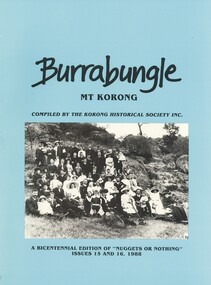
Book - BURRABUNGLE MT KORONG, 1988
Burrabungle Mt Korong compiled by the Korong Historical Society Inc, a Bicentennial edition of '' Nuggets or Nothing '' issues 15 and 16 1988. Published by The Korong Historical Society Inc, contains 57 pages with black and white photographs and maps, blue cover with group photograph picnic at Mt Korong 1912.Betty Ling, Judy Lorraine, Keith Ringbook, rural, shire of korong, shire of korong - history, early settlers, gold discovery, mt korong. -
 Bendigo Historical Society Inc.
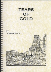
Book - TEARS OF GOLD, FATALITIES ON THE BENDIGO GOLDFIELDS 1852 - 1950, 2010
Tears of Gold, fatalities on the Bendigo Goldfields 1852-1950. Signed by the author, John R. Kelly, 6 July 2010, dedication thanks to the Bendigo Historical Society Soft covered spiral bound book of 91 pages with black and white photographs, maps and illustrations.John Kellybendigo, gold mining, fatalities, bendigo history, goldmining, miners, mine accidents, family history. -
Bendigo Historical Society Inc.
Document - MCCOLL, RANKIN AND STANISTREET COLLECTION: EAST CLARENCE GOLD MINING CO NL, 1932 - 1946
Document. Envelope contains:- Insurance Policies, Receipts Hire agreement for Steam driven air compressor and site map and specifications. Tender for new compressor, treasure Bonds and Lease Agreements. Envelope with a 2 pence red postage stamp with the profile of King George 5th and a crown above his head addressed to Mrs C. Russell of 7 Willowbank Road N7, Melbourne. War Damage Commission receipts.Correspondence from The English Scottish & Austranlan Bank Limited regarding Treasury Bonds. Receipt for Boiler Test, Certificate of inspection of Boiler.McColl, Rankin & Stanistreetorganization, business, gold mining - legal, mccoll, rankin & stanistreet, east clarence gmc nl, gold mining, insurance policies, steam driven air compressor, tender for new compressor, treasury bonds, lease agreements. r.e. ludowici & caldwell g.m. coy. mr j.j. hall, miss g. alice jones. -
 Bendigo Historical Society Inc.
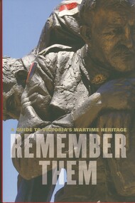
Book - REMEMBER THEM, 2009
Rember Them a guide to Victorias's wartime heritage, a 308 page hardcover book containing photographs in colour & black & white and maps. Funded by the Government of Victoria and produced by the Veteran's unit, Dept of Planning and Community Development. Published by Hardie Grant Books Prahran.Government of Victoriabook, wartime heritage, victoria's wartime heritage, war memorials. -
 Bendigo Historical Society Inc.
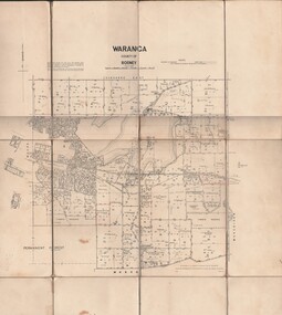
Map - JACK FLYNN COLLECTION: WARANGA, 1959
... Inc. History House 11 Mackenzie Street Bendigo goldfields MAP ...Map: Parish of Waranga, County of Rodney. Parish plan.By Authority. A.C. Brooks. Government Printer Melbourne. Drawn and Reproduced at the Department of lands and survey. Melbourne 1959.map, rodney, parish plan, waranga -
 Bendigo Historical Society Inc.
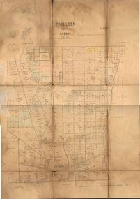
Map - JACK FLYNN COLLECTION: TOOLLEEN, 25/05.1926
... Inc. History House 11 Mackenzie Street Bendigo goldfields MAP ...Map: Parish of Toolleen, County of Rodney. Parish plan.By Authority, H.J. Green. Govt., Printer. Photo-Lithographed at the Department of Lands and Survey Melbourne. W. J. Butson 25.5.26.map, rodney, parish plan, toolleen -
 Bendigo Historical Society Inc.
Map - JACK FLYNN COLLECTION: TARNAGULLA SHEET 4, 25/11/1926
... Inc. History House 11 Mackenzie Street Bendigo goldfields MAP ...Map: Parish of Tarnagulla Sheet 4, Counties of Gladstone and Bendigo. Parish plan.Photo-Lithographed at the Department of lands and Survey, Melbourne by W. J. Butson. 25.11.26map, gladstone, parish plan, tarnagulla sheet 4