Showing 2320 items matching "melbourne street plan"
-
 Hume City Civic Collection
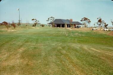
Photograph, c 1978
On 4th August 1978 the construction of the Goonawarra Estate commenced. The estate was formerly known as the Goonawarra Farm and overlooked the Sunbury Township and the Jacksons Creek Valley. Plans for the development included a golf course, houses and community and recreational facilities. The golf course opened in 1980 and the housing construction continued throughout the last two decades of the twentieth century and into the twenty first century.A coloured photograph of the clubhouse at the Goonawarra Golf Course taken from the 10th fairway. Parked cars are visible on the RHS of the photograpg and there is a row of gum trees behind the clubhouse.goonawarra golf club, goonawarra farm, goonawarra housing estate, housing developments, sharkey, robert b., kilkenny homes, australian ideas homes pty.ltd., glamor homes, craftsmen homes., villa bella homes, george evans collection -
 Hume City Civic Collection
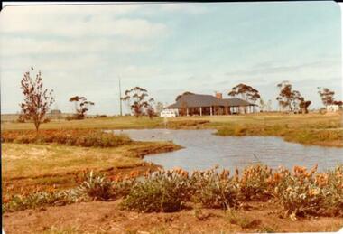
Photograph, c 1978
On 4th August 1978 the construction of the Goonawarra Estate commenced. The estate was formerly known as the Goonawarra Farm and overlooked the Sunbury Township and the Jacksons Creek Valley. Plans for the development included a golf course, houses and community and recreational facilities. The golf course opened in 1980 and the housing construction continued throughout the last two decades of the twentieth century and into the twenty first century.A coloured photograph of the clubhouse at Goonawarra Golf Course as seen from the 10th green. A small white van is parked ouitside the building. There is a line of trees behind the clubhouse.goonawarra golf club, goonawarra farm, goonawarra housing estate, housing developments, sharkey, robert b., kilkenny homes, australian ideas homes pty.ltd., glamor homes, craftsmen homes., villa bella homes, george evans collection -
 Hume City Civic Collection
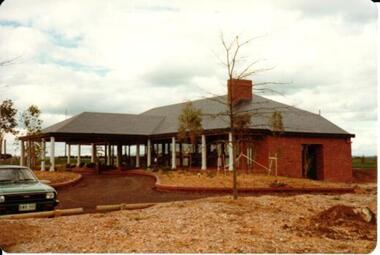
Photograph, 1/10/1978
On 4th August 1978 the construction of the Goonawarra Housing Estate commenced. The estate was formerly known as the Goonawarra Farm and overloked the Sunbury town area and Jacksons Creek valley. Plans for the new development included a gold course, housing, community and recreational facilities. The construction continued througout the last two decades of the twentieth century and into the twenty first century.A coloured photograph of the clubhouse taken from the south west at the Goonawarra Golf Club. The surrounding garden has been planted out with trees and has been mulched. A green car is on the LHS of the photograph.goonawarra farm, goonawarra golf club, goonawarra housing estate, sharkey, robert b., kilkenny homes, australian ideas homes pty.ltd., craftsmen homes., glamor homes, villa bella homes, george evans collection -
 Hume City Civic Collection
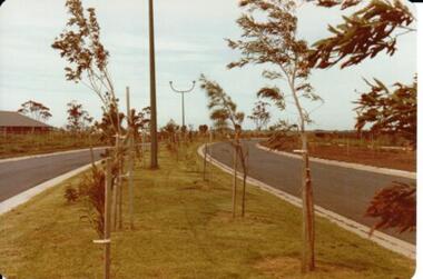
Photograph, 1/11/1980
On 4th August 1978 the construction of the Goonawarra Housing Estate commenced. The estate was formerly known as the Goonawarra Farm and overloked the Sunbury town area and Jacksons Creek valley. Plans for the new development included a gold course, housing, community and recreational facilities. The construction continued througout the last two decades of the twentieth century and into the twenty first century.A coloured photograph of Francis Boulevard at the Goonawarra Estate showing the entrances and landscaping and looking south to Sunbury Road and Jacksons Hill (Sheoak Hill).goonawarra farm, goonawarra golf club, goonawarra housing estate, kilkenny homes, craftsmen homes., australian ideas homes pty.ltd., villa bella homes, glamor homes, george evans collection -
 Hume City Civic Collection
Photograph, 1/08/1980
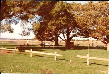
On 4th August 1978 the construction of the Goonawarra Estate commenced. The estate was formerly known as the Goonawarra Farm and overlooked the Sunbury farm and the Jacksons Creek valley. Plans for the new development included a golf course, houses, community and recreational facilities. The golf course opened in 1980 and the housing construction continued throughout the last two decades of the twentieth century and into the twenty first century.A coloured photograph of a barbecue and picnic area at Goonawarra. The photograph shows the Stage 3 development of the area.goona warra golf club, goonawarra farm, goonawarra housing estate, sharkey, robert b., kilkenny homes, craftsmen homes., australian ideas homes pty.ltd., glamor homes, villa bella homes, george evans collection -
 Hume City Civic Collection
Photograph, 1/08/1980
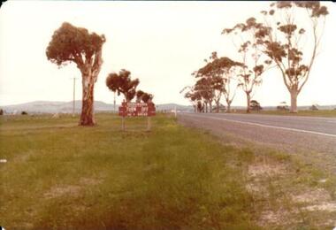
On 4th August 1978 the construction of the Goonawarra Estate commenced. The estate was formerly known as the Goonawarra Farm and overlooked the Sunbury town and the Jacksons Creek valley. Plans for the development included a golf course, houses, community and recreational facilities..The golf course opened in 1980 and the housing construction continued throughout the last two decadesd of the twentieth century and into the twenty firsat century.A coloured photograph showing the signpost indicating the entrance to the Goonawarra Estate from Sunbury Road. Trees are growing on either side of the road and Mt. Holden can be seen across the skyline.goona warra golf club, goonawarra farm, goonawarra housing estate, sharkey, robert b., kilkenny homes, australian ideas homes pty.ltd., craftsmen homes., glamor homes, villa bella homes, mt. holden, george evans collection -
 Hume City Civic Collection
Photograph, 1/08/1978
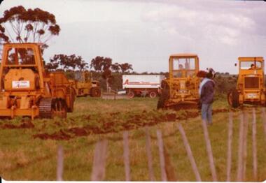
On 4th of August 1978 work began on the construction of the Goonawarra Estate on land that was the former Goonawarra Farm which overlooked the town of Sunbury abnd the Jacksons Creek valley. Plans for the new development included a golf course, houses, community and recreational facilities.The golf course openrd in 1980 and housing construction continued throughout the last two decades of the twentieth century and into the twentieth first century.A coloured photograph of the first sod being turned at the Goonawarra Estate. Four large pieces of earth-moving machinery and a large semi-trailer are in picture. A man is standing in the foreground.goona warra golf club, goonawarra farm, goonawarra housing estate, housing developments, sharkey, robert b., killkenny homes, australian ideas homes pty.ltd., craftsmen homes., glamor homes, villa bella homes, george evans collection -
 Hume City Civic Collection
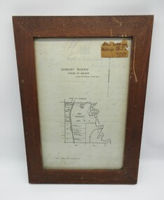
Plans, SUNBURY RESERVE PARISH OF HOLDEN
This object is a plan of a proposed recreation ground at Munro's. This was unfenced land between Evans and Barkly Streets adjacent to the Asylum boundary, now Jacksons Hill.A wooden framed plan of a proposed recreation ground.sunbury, sunbury asylum, george evans collection -
 Clunes Museum
document
INFORMATION ABOUT A STAMP SHOE FROM A CORNISH STYLE SQUARE-HEAD STAMP BATTERY POSSIBLY USED BY PORT PHILLIP MINE, CLUNES, FROM MATTHEW CHURCHWARD, SENIOR CURATOR, ENGINEERING & TRANSPORT, MUSEUM OF VICTORIA LETTER DATED 15 OCTOBER, 1997. THE GOLDFIELDS AND MINERAL DISTRICTS OF VICTORIA. GOLD ITS OCCURRENCE AND EXTRACTION, PLAN OF GOLD MINING COMPANIESINFORMATION RECEIVED REGARDING THE PORT PHILLIP MINE; Including .1 COPY OF ARTICLE 12TH MAY, 1858 FROM "THE ARGUS." MELBOURNE. .2 LETTER FROM "SCIENCEWORKS" TO MR. ALAN KEEBLE DATED 15/10/1997 (3 Pages) .3 SECTION OF MERCURY, TROUGHS, STAKES & STAMPS (Extract taken from publication, The Gold Fields, Mineral Districts of Victoria, by R. Brough Smyth F.G.S, published by Queensberry Hill Press 1979) .4 GOLD. ITS OCCURRENCE AND EXTRACTION (Extract taken from publication, Gold: Its Occurrence and Extraction by Alfred G. Lock F.R.G.S published by E. & F. N. Spon 16 Charing Cross London 1882) .5 PLAN OF GOLD MINING CO'S. CLUNES (Extract taken from Dicker's Mining Record 26/3/1867, page 173. https://trove.nla.gov.au/work/32734386?q&versionId=39944948) local history, mining, company exploration -
Clunes Museum
Plan - ARCHITECTS PLANS, DARYL JACKSON REPORT PTY. LTD
SKETCH DESIGN REPORT - WESLEY AT CLUNESARCHITECTS PLAN WESLEY AT CLUNES. DARYL JACKSONlocal history, document, plans, education, schools, wesley -
Clunes Museum
Document - MANAGEMENT PLAN REVIEW, JEANETTE SPITTLE - UNIVERSITY OF MELBOURNE BURNLEY CAMPUS, A REVIEW OF THE MANAGEMENT OF QUEENS PARK, CLUNES FROM AN HISTORICAL, SOCIAL AND ENVIRONMENTAL CONTEXT, NOVEMBER 2006
PROJECT BY JEANETTE SPITTLE A STUDENT OF THE UNIVERSATYOF MELBOURNE, BURNLEY CAMPUS COMPILED NOVEMBER 2006A SOCIAL,HISTORICAL AND ENVIRONMENTAL REVIEW OF QUEENS PARK. IN BLACK FOLDER, 64 PAGES PLUS APPENDIX 2, PUBLISHED 2006documents, local history, queens park, park management -
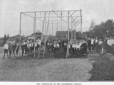 Canterbury Primary School
Photograph, Gymnasium
Gymnasium built to a design brought back to Canterbury from the USA. No longer there.2 Photographs and 1 plan of a gymnasium located on the north side of school. -
 National Wool Museum
Sculpture - Bollard, Jan Mitchell, The Lost Bollards, 1999
Geelong is famous for its bollards. Created by local artist Jan Mitchell, the colourful bollards spot the foreshore, representing a fascinating and fun chronicle of the city’s past. Few people know that Mitchell planned for a flock of sheep to be part of her public art project. The wool industry is an important part of Geelong’s history, so Mitchell thought what better than a flock of sheep to welcome people to the city. The flock (and a Shepard) were to be placed out on the Melbourne-Geelong highway, near Lara, to welcome travellers to the city. The sheep would then be scattered along the road as a wayfinding signal to bring people to Geelong. When traffic authorities heard the plan for bollard sheep along the road, they squashed the project as a potential distraction for drivers. Another flock was also suggested for the hills of the eastern gardens, overlooking the bay. This was also disapproved; so Mitchell only ever partially completed four sheep bollards. The bollards are remnants of Jan Mitchell’s flock of sheep. The sheep also show the evolution of one of Geelong’s most iconic art installations. From the first sheep showing the raw timber of the old Yarra Street pier, to the sheep without a face, through to the completed sheep, it is possible to trace Mitchell’s process in the preparation of the bollards. The lost bollards form part of the National Wool Museum’s unique collection. The first bollard is the least complete, still in its original timber colour. From the central cylindrical shape, an additional wedge protrudes. This unpainted wedge forms what would have been the face of the sheep, with an ear present on either side that would have been painted white. Presently they are a bare metal. No legs are present on this bollard. The second and third bollard are completed to a similar level. They have a central cylindrical shape with an additional wedge protruding from the front of the timber. This wedge forms what would have been the face of the sheep, with an ear present on either side. The face and ears have been painted white but the finer details such as the eyes have not been added. These bollards bodies have also been painted white and have their legs attached. The legs are thin metal cylinders, approximately 50mm in diameter and 500mm long. The fourth bollard Is complete. It has the same central cylindrical shape with an additional wedge protruding from the front of the timber. This wedge forms the completed face of the sheep, with an ear present on either side that has been painted white. The face also features completed painted eyes. This bollard has its legs attached. The legs are thin metal cylinders, approximately 50mm in diameter and 500mm long. geelong, bollards, geelong's bollards, jan mitchell -
National Wool Museum
Book, Report by the wool marketing committeee to the Australian Wool Board, vol. 2, Oct 1967
"Report by the wool marketing committee to the Australian Wool Board, vol. 2, Oct 1967", Appendix to report by the Australian Wool Board presented to the Australian Wool Industry Conference Melbourne, 1967wool sales wool marketing wool brokering wool sales - floor price scheme wool sales - price averaging plan wool sales - private treaty wool sales - auction system, australian wool board, wool sales, wool marketing, wool brokering, wool sales - floor price scheme, wool sales - price averaging plan, wool sales - private treaty, wool sales - auction system -
Whitehorse Historical Society Inc.
Article, Councils slate transport plan, 1979
The reaction of Camberwell and Nunawading Councils to a newly released State Government plan for transport in the area.The reaction of Camberwell and Nunawading Councils to a newly released State Government plan for transport in the area. Most proposals are concerned with the extension of freeways or improvement of roads. Concern is expressed about the lack of public transport improvements.The reaction of Camberwell and Nunawading Councils to a newly released State Government plan for transport in the area.city of nunawading, city of camberwell, roads and streets, transport, public transport, eastern freeway -
Whitehorse Historical Society Inc.
Document, Colombo Street Buildings, 1/06/2004 12:00:00 AM
Detailed plans and drawings of proposed multi-storey buildings for Colombo Street, Mitcham.Detailed plans and drawings of proposed multi-storey buildings for Colombo Street, Mitcham. Also includes photos of Mitcham area around the buildings.Detailed plans and drawings of proposed multi-storey buildings for Colombo Street, Mitcham.colombo street, mitcham, mitcham, whitehorse road, mitcham, mitcham railway station, st johns catholic church, mitcham, station street, mitcham, high rise buildings -
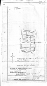 Whitehorse Historical Society Inc.
Document, Subdivision of part of W.B. Wickings Estate, 1952
Plan of subdivision of part of W.B. Wickings Estate, 1952. Reticulation area 1457, Sewer through private property. Melbourne and Metropolitan Board of Works document.land subdivision, holland road, blackburn south, constance street, gissing street, rosen street, wicking court, melbourne and metropolitan board of works, sewerage and sanitation, wicking, walter benjamin -
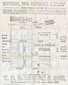 Whitehorse Historical Society Inc.
Document, Kings Padddock Blackburn
Plan showing land for sale at Kings PaddockPlan showing land for sale at Kings Paddock, Blackburn (second section).Plan showing land for sale at Kings Paddockauctions, kings paddock, blackburn, south parade, laburnum street, the avenue, fuchsia street, laurel grove, main street, t.r.b. morton & son -
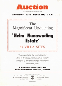 Whitehorse Historical Society Inc.
Document, Helm Nunawading Estate, 1957
Brochure advertising auction of 63 villa sitesBrochure advertising auction of 63 villa sites ' Helm Nunawading Estate', North East of Cnr Springvale Road and Springfield Road in Mitcham 17 November 1957. Auctioneers Wm. White & Sons, Frank Fisher & Co. Allotments sold for 400 pounds on high side of street, 350 pounds on lower side according to attached note by Bob Hirschfield in 1985. Includes plan of subdivision.Brochure advertising auction of 63 villa sites auctions, helm nunawading estate, olwen street, nunawading, efron street, springvale road, hirschfield, bob, william white and son, frank fisher & co. -
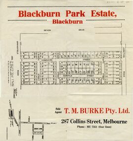 Whitehorse Historical Society Inc.
Document, Blackburn Park Estate, n.d
Land Sale plan for 'Blackburn Park Estate'Land Sale plan for 'Blackburn Park Estate' between Springfield and Junction Roads. Agent T.M. Burke Pty Ltd.Land Sale plan for 'Blackburn Park Estate'blackburn park estate, blackburn north, springfield road, junction road, sussex street, essex street, yorkshire street, lulworth street, norfolk street -
Whitehorse Historical Society Inc.
Document, Certificate of Title, 21/07/1920 12:00:00 AM
Certificate of Title vol.4351 fol. 870161 for Lots 19 and 79, Plan of Subdivision no. 3212, Blackburn, owned by Thomas James HamiltonCertificate of Title vol.4351 fol. 870161 for Lots 19 and 79, Plan of Subdivision no. 3212, Blackburn, owned by Thomas James HamiltonCertificate of Title vol.4351 fol. 870161 for Lots 19 and 79, Plan of Subdivision no. 3212, Blackburn, owned by Thomas James Hamiltonhamilton, thomas james, station street blackburn -
Whitehorse Historical Society Inc.
Legal record - Document, Certificate of Title, 28/10/1913 12:00:00 AM
Certificate of Title for Lot 41, Plan of Subdivision no. 2525, Deakin Street Mitcham, owned by State Savings Bank of Victoria.Certificate of Title for Lot 41, Plan of Subdivision no. 2525, Deakin Street Mitcham, owned by State Savings Bank of Victoria.Certificate of Title for Lot 41, Plan of Subdivision no. 2525, Deakin Street Mitcham, owned by State Savings Bank of Victoria.deakin street mitcham, state savings bank of victoria -
Whitehorse Historical Society Inc.
Article, Developer proffers new plan, 2005
Compromise plans for multi-storey apartment towers in Colombo Street Mitcham, rejected by Whitehorse CouncilCompromise plans for multi-storey apartment towers in Colombo Street Mitcham, rejected by Whitehorse CouncilCompromise plans for multi-storey apartment towers in Colombo Street Mitcham, rejected by Whitehorse Councilhigh-rise buildings, colombo street, mitcham, planning development -
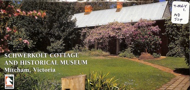 Whitehorse Historical Society Inc.
Pamphlet, Schwerkolt Cottage and Historical Museum, 1/06/1998
Whitehorse City Council publicity pamphlet giving the history of the cottage and the Schwerkolt family. Includes the farm in Separation Street, Northcote. In Mitcham the farm was a 'mixed' one with fruit trees, vines, dairying, poultry, bee hives, wine making and a stone quarry. Includes details of the museum, coloured photographs and locality and site plans.jackschowsky, mary elizabeth, schwerkolt, johann august, richter, paulina, oppel, maria catherina wilhelmine, deep creek road, mitcham, city of whitehorse, nunawading and district historical society inc, city of nunawading, delacombe, rohan (sir), schwerkolt cottage -
Whitehorse Historical Society Inc.
Document, A Plan for Mitcham, 1960s
Mitcham chamber of Commerce pamphlet plans for developing Mitcham Shopping Centre to provide off-road parking. Aerial view illustration of shopping centre on cover.Mitcham chamber of Commerce pamphlet plans for developing Mitcham Shopping Centre to provide off-road parking. Aerial view illustration of shopping centre on cover.Mitcham chamber of Commerce pamphlet plans for developing Mitcham Shopping Centre to provide off-road parking. Aerial view illustration of shopping centre on cover.parking, mitcham shopping centre, armstrong, raleigh edward, colombo street, mitcham, elizabeth street, mitcham, mitcham road, mitcham, whitehorse road, mitcham, mitcham chamber of commerce -
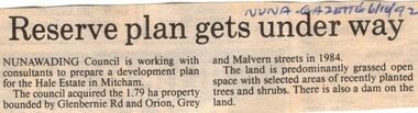 Whitehorse Historical Society Inc.
Article, Reserve plan gets under way, 6/10/1992 12:00:00 AM
Article on the development planArticle on the development plan of the Hale Estate, Mitcham.Article on the development planhale estate, mitcham, glenburnie road, orion street, vermont, grey street, malvern street, land subdivision -
Whitehorse Historical Society Inc.
Document, Descendents of Albert Edward Henry Charlesworth, 1/10/2002 12:00:00 AM
Family tree of Albert Henry Charlesworth, includes plan of Charlesworth Estate, MitchamFamily tree of Albert Henry Charlesworth, includes plan of Charlesworth Estate, MitchamFamily tree of Albert Henry Charlesworth, includes plan of Charlesworth Estate, Mitchamcharlesworth, albert edward henry, charlesworth, albert roy, family trees, charlesworth family, mcintyre family, collins family, wallace family, charlesworth estate, mitcham, doncaster east road, mitcham, harrison street, mitcham, barrett street, mitcham, quarry road, mitcham -
Whitehorse Historical Society Inc.
Map, Plan, 1939
Plan of subdivision, part of crown portion 83A and 83, Parish of Nunawading, County of BourkePlan of subdivision, part of crown portion 83A and 83, Parish of Nunawading, County of BourkePlan of subdivision, part of crown portion 83A and 83, Parish of Nunawading, County of Bourkestreet names, parish of nunawading, station street, blackburn, railway road, blackburn, vine street, blackburn, south parade, blackburn, laburnum street, blackburn, main street, blackburn, gardenia street, blackburn, the avenue, blackburn, fuschia street, blackburn, linum street, blackburn -
Whitehorse Historical Society Inc.
Map, Parish of Nunawading, 1939
Plan of subdivision part of crown portions 81, 82 and 89,Plan of subdivision part of crown portions 81, 82 and 89, Parish of Nunawading, County of Bourke, Blackburn Wellington Avenue amended from Stanley RoadPlan of subdivision part of crown portions 81, 82 and 89, street names, parish of nunawading, blackburn road, blackburn, wellington avenue, blackburn, wolseley crescent, blackburn, gordon crescent, blackburn, clarke street, blackburn, central road, blackburn -
Whitehorse Historical Society Inc.
Letter - Correspondence, Obtaining a grant of Crown Land at rear of Myrtle Grove, 1932
Correspondence between Council and Closer Settlement Board re land in Pakenham Street including plans of allotments.Correspondence between Council and Closer Settlement Board re land in Pakenham Street including plans of allotments. Also further correspondence re land being sold by Malcolm Sheehan to Dal Hear.Correspondence between Council and Closer Settlement Board re land in Pakenham Street including plans of allotments.pakenham street, blackburn, myrtle grove, blackburn, shire of blackburn and mitcham, sheehan, malcolm, hearn, dal, victoria. closer settlement board