Showing 22369 items
matching park
-
 Port Fairy Historical Society Museum and Archives
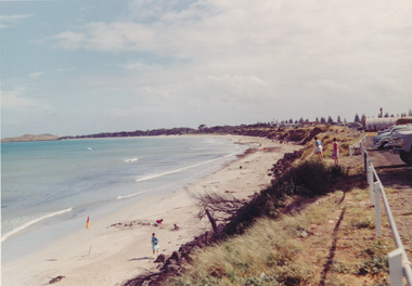
Photograph
East beach car park and sandColoured photograph of Expanse of East Beach from the car park people playing on sandeast beach, car park, sandcastle, caras, dune -
 Melbourne Tram Museum
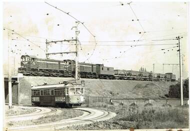
Photograph - Black & White Photograph/s, John Dare, 1983
Black and white print of VR locomotives Y158 and Y159 on a ballast train crossing over the tram track at Royal Park with W6 989 on a route 68 on the Royal Park Line. Photo by John Dare, 22/8/1983.On rear in ink "Y158, Y159 on ballast train at Royal Park as tram No. 989 bound for West Coburg crosses beneath on 22/5/1983 / John Dare"trams, tramways, royal park, west coburg, vr, tram 989 -
 Lakes Entrance Historical Society
Photograph - Camp Park, 1949
Also two other black and white photographs taken at park in a caravan 05437.1 and 5437.2Black and white photograph of entry to holiday park Lakes Entrance Victoriacamping, businesses, tourism -
 Port Fairy Historical Society Museum and Archives
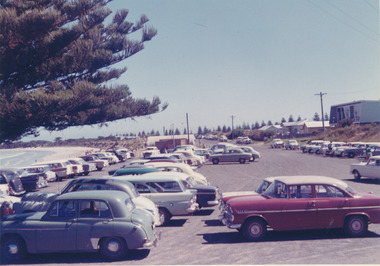
Photograph
East Beach Car ParkColoured photograph East Beach car park around 1970’s with weatherboard house on righteast beach, car park, cars, half round shed -
 Whitehorse Historical Society Inc.
Document, Schwerkolt Cottage, c1985
1984/5 Budget for Schwerkolt CottageCity of Nunawading Parks and Recreation Department leaflet on Schwerkolt Cottage.non-fiction1984/5 Budget for Schwerkolt Cottageschwerkolt cottage, city of nunawading -
 Melbourne Legacy
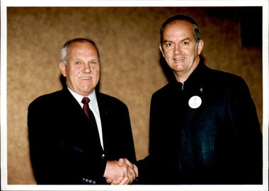
Photograph - Past presidents, Legatees Ford and Parkes, 2003
Photograph of outgoing President for 2002, Legatee Parkes welcoming the incoming President for 2003, Legatee David Ford. A record of the intended president for 2003 being welcomed by the outgoing president.Colour photo x 2 of Legatees Ford and Parkes shaking hands.past presidents, tony parkes, david ford -
 Marysville & District Historical Society
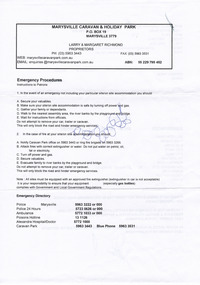
Document (Item) - Receipt, Larry and Margaret Richmond, 2000
A receipt for a deposit paid for an unpowered site at the Marysville Caravan Park that was issued in 2000.A receipt for a deposit paid for an unpowered site at the Marysville Caravan Park that was issued in 2000.marysville, victoria, australia, marysville caravan park, accommodation, receipt -
 Whitehorse Historical Society Inc.
Book, Forty years & beyond, 2006
A story about Antonio Park Primary School from 1966-2000 and beyond.A story about Antonio Park Primary School from 1966-2000 and beyond. Comp. by the staff of Antonio Park primary School. Copy of paintings of acacia and grevillea by Wendy Rees-Harrison as frontispiece.A story about Antonio Park Primary School from 1966-2000 and beyond. antonio park primary school, paintings -
 Stawell Historical Society Inc
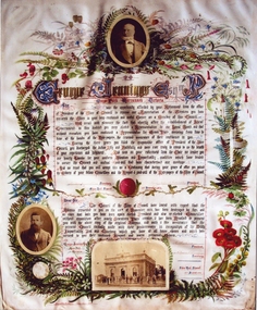
Photograph, Mr George Jennings -- Illuminated Address
Illuminated Address for George Jennings "Mayo Park" Lubeck. The top photo is of George Jennings, The other portrait is of Alfred Clemes. The illumination was given to George Jennings for his serviced over many year to the council. Enlarged colour photograph of an illuminated address presented by Stawell Shire Council. Included in the folder is a Black and white photograph also of the illumination in a brown folder. Included in the illumination are three photographs, two of males and one of a building with people. Floral decorations surround the writing and photographs. George Jennings Esq Mayo Park, Warranook Victoria stawell shire president -
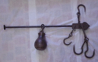 National Wool Museum
Steelyard
Steelyard used for weighing wool and wheat on "Moor Park" on Yarriariak Creek, twenty miles from Horsham, Victoria.Steelyard used for weighing wool and wheat on "Moor Park" on Yarriariak Creek.sheep stations management, wool growing, hamilton, mr robert g, sheep stations - management -
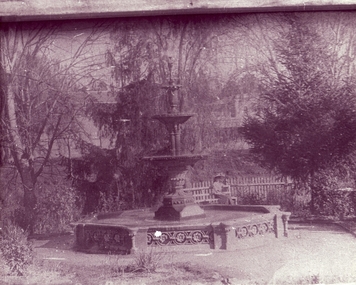 Clunes Museum
Photograph - PHOTOGRAPH QUEENS PARK
FOUNTAIN IN QUEEN'S PARK, CLUNES LADY SITTING ON GARDEN BENCH BESIDE PICKET FENCEBLACK AND WHITE PHOTOGRAPH OF FOUNTAIN IN QUEEN'S PARK, CLUNES. LADY SITTING ON BENCH.POSTCARD TO HELENA DAVIES, MARYFIELD 1909local history, photography, photographs, queen's park garden -
 Lakes Entrance Historical Society
Postcard - Albert Park Lake Tyers, 1910c
Note on back to Miss Barber from Betty saying she asked Mrs Blay about accommodation etc. Also another postcard 03833.2 to a Clarence Pawsey dated 18.3.1918Sepia toned postcard showing Albert Park Guest House consisting of bedroom wing on left and detached kitchen dining wing on right, verandah across front of building with two deck chairs and bench on verandah, man and lady standing and lady sitting on bench. Extensive paths and garden in front, glimpses of other buildings at back. Two water tanks at left one round galvanized and one square, trees behind building. Lake Tyers VictoriaAlbert Park Lake Tyers Victoriawaterways, topography, guesthouses -
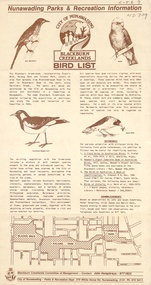 Whitehorse Historical Society Inc.
Pamphlet, Blackburn Creeklands Bird List, 1/07/1986
Blackburn Creeklands Bird List , City of Nunawading.Blackburn Creeklands Bird List , City of Nunawading, Nunawading Parks and Recreation information, July 1986.Blackburn Creeklands Bird List , City of Nunawading. city of nunawading. parks and recreation department., blackburn creeklands, birds, humphries, jon, susan, valentine, peter, zappe, hilda, beck, merlin -
 City of Ballarat
Artwork, other - Public Artwork, Joe Pratt et al, Hidden Waterway, 2016
To create 'Hidden waterway' (2016) Artist Forest Keegel held workshops with the people of Ballarat East who drew images in the park of threatened local fauna and waterbugs that once inhabited this land. Those images were then translated into carvings by sculptor Joe Pratt across 20 boulders creating a trail throughout the park. The artwork is of aesthetic and social significance to the people of Ballarat20 bluestone boulders with carvings across the surface creating a trail throughout the park forest keegel, joe pratt, ballarat east, pennyweight park -
 Flagstaff Hill Maritime Museum and Village
Badge - Legacy Appeal badge, A.J. Parkes, 1966
This Legacy badge is one of a set of badges collected by Dr W R Angus from the organisations in which he was involved. The badge was made by A.J. Parkes of Brisbane, an Australia-wide firm that has been making badges for over a century. The $2' and "£1" (one pound) embossed on the back dates the badge dates the badge to the year 1966 when Australian money was in the process of converting from pounds and pence to decimal currency's dollars and cents. It is interesting to note that the dollar sign "$2" has two vertical lines through the 'S', but the Australian currency sign for a dollar has only one vertical line. The badge may have been produced before the date of decimal conversion, which began on February 14th, 1966. A J Parkes may have ordered the badges before the published use of the dollar symbol. The set of badges is now part of Flagstaff Hill’s comprehensive W.R. Angus Collection, donated by the family of Dr W R Angus, surgeon and oculist. The W.R. Angus Collection: - The W.R. Angus Collection includes historical medical equipment, surgical instruments and material belonging to Dr Edward Ryan and Dr Thomas Francis Ryan, (both of Nhill, Victoria) and Dr Angus’ own belongings. The Collection’s history spans the medical practices of the two Doctors Ryan, from 1885-1926 plus that of Dr Angus, up until 1969. It includes historical medical and surgical equipment and instruments from the doctors Edward and Thomas Ryan of Nhill, Victoria. Dr Angus married Gladys in 1927 at Ballarat, the nearest big city to Nhill where he began as a Medical Assistant. He was also Acting House surgeon at the Nhill hospital where their two daughters were born. During World War II He served as a Military Doctor in the Australian Defence Forces. Dr Angus and his family moved to Warrnambool in 1939, where Dr Angus operated his own medical practice. He later added the part-time Port Medical Officer responsibility and was the last person appointed to that position. Both Dr Angus and his wife were very involved in the local community, including the planning stages of the new Flagstaff Hill and the layout of the gardens there. Dr Angus passed away in March 1970.This badge is significant for connecting Doctor Angus to organisations that he supported. It is also historically significant for representing Australia's conversion to decimal currency. The W.R. Angus Collection is significant for still being located at the site it is connected with, Doctor Angus being the last Port Medical Officer in Warrnambool. The Collection includes historical medical objects that date back to the late 1800s.Legacy Appeal badge; an oval-shaped metal and enamel badge, white enamel on gold, with the Legacy symbol of a flaming torch in the centre. It has a vertical stick pin and inscriptions on the back. It was made by A.J. Parks, Brisbane. The badge was given to a donor of $2 (£1 or one pound) to Legacy. This badge is part of a set of badges collected by Dr W R Angus. the set represents organisations that he was involved in, and is part of the W.R. Angus Collection.Embossed: "PARIVETTE 77-“ "A J PARKES" "BRISBANE" "£1" (one pound) "$2” (2 dollars) flagstaff hill, warrnambool, maritime village, maritime museum, shipwreck coast, great ocean road, badge, legacy badge, organisation badge, a.j. parkes, donor's badge, £1 badge, $2 badge, 14th february 1966, australian decimal conversion, brisbane, legacy appeal, w.r. angus collection -
 Northern District School of Nursing. Managed by Bendigo Historical Society Inc.
Photograph - Mayfort House
The Northern District School of Nursing opened in 1950 in to address the issues around nurse recruitment, training and education that had previously been hospital based. The residential school was to provide theoretical and in-house education and practical training over three years. The students would also receive practical hands-on training in the wards of associated hospitals. The Northern District School of Nursing operated from Lister House, Rowan Street, Bendigo. It was the first independent school of nursing in Victoria and continued until it closed in 1989.B&W photograph of Mayfort House, nurses' accommodation, 148 Wattle Street, Bendigo. Now demolished, site of present-day car park.Mayfort House, nurses' accommodation, 148 Wattle Street, Bendigo. Now demolished, site of present-day car park.ndsn, nursing -
Glenelg Shire Council Cultural Collection
Slide - Lantern Slides, n.d
Two glass lantern slides in cardboard box, both showing men at working bees (two different images) at Hanlon Park. Photo on one glass slide, then another plain glass slide fixed over image. Slides bound with white adhesive tape. Box has maker's label on front, label advising what to do if slides are fault, on bottom.Front: a) 'Some of the 'BUSY-BEES' HANLON PARK PORTLAND ' written in black pen, top of slide 'SOME OF THE 'BEES' HANLON PARK PORTLAND' scratched into slide, bottom. b) 'SOME OF THE 'BEES' HANLON PARK PORTLAND' -pen, top of slide 'THE BEES HANLON PARK PORTLAND TOYE PHOTO' scratched into slide, bottom -
 Halls Gap & Grampians Historical Society
Document - Article (magazine/newspaper)
Article (3pages) written by David Catrice for Parks Victoria. More history on Walter Zumstein and the Zumstein area can be found on p137, 153 -156, 83, 107, 136 of "Victoria's Wonderland: a Grampians History"3page Article describes Walter Zumstein and the area known as 'Zumstein's'. Entitled Zumstein's Crossing, Grampians National Park from "Victoria's Heritage", Parks Victoria c1995media, magazine articles -
 Kew Historical Society Inc
Photograph - Civic event in Stradbroke Park, 1976
Stradbroke Park. Extent: Kilby Road to Harp Road at Burke Road. Historical Documentation: 1851 - Portion 91 purchased by Edward Glynn; 1888 - The Harp of Erin Estate (which included Section 91) offered for sale; 1896 - The area now known as Stradbroke Park was bisected by a creek that flowed from the Yarra via Hay's Paddock (q.v.) and extended through to Burke Road; 1943 - W.D. Birrell, Town Clerk of Kew, proposed that the creek be filled and a reserve created; 1954 - Entire area designated as 'open space' and named 'Stradbroke Park'. The line of the creek that ran through the Park created a further reserve on the north side of High Street, now known as 'Harrison Reserve'. Existing Condition: The park is largely of mown grass that has mature trees set into it It is possible that a number of these are remnant of the original vegetation, while there are also a number of exotic trees introduced, particularly at the northern end of the park. The southern end is dominated by playing fields. (Source: Sanderson, P 1988. Kew Conservation Study)Colour photographic positive (with colour degradation) of sporting teams at a civic event in Stradbroke Park in Kew East in May 1976. The event was officiated by the Mayor of Kew, Cr Alan Hutchinson. Stradbroke Park is situated on the western boundary of Kew and bordered by Burke and Harp Roads.stradbroke park, cr alan hutchinson, team sports -- kew (vic.) -
Whitehorse Historical Society Inc.
Photograph - Illustration, Mary Ann Jeffery, n.d
Photocopy of portrait of Mary Ann Jeffery, 1853 - 1943Photocopy of portrait of Mary Ann Jeffery, 1853 - 1943 (from 'Sevenoaks Park' by R. de Costa)Photocopy of portrait of Mary Ann Jeffery, 1853 - 1943jefferey, mary ann -
 National Wool Museum
Book, Hall & Stells, Ltd, Makers of Machinery
"Hall & Stells, Ltd, Makers of Machinery, Park Works, Keighley, Eng", catalogue of machinery."Hall & Stells, Ltd, Makers of Machinery, Park Works, Keighley, Eng", catalogue of machinery.textile machinery, hall and stells limited -
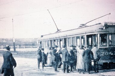 Melbourne Tram Museum
Slide - Black and white reproduction photograph - HTT Wattle Park line c1917
Photograph - HTT Wattle Park line c1917, bogie tram 20 loading many passengers. The tram is showing the destination of Wattle Park. Open fields in the background. Appears to be at least one solider waiting to board the tram.Yields information about the Wattle Park line and the trams used.Kodachrome cardboard duplicate slide - Black and white reproduction photograph - HTT Wattle Park line c1917 "MP8" in penciltrams, tramways, opening, htt, hawthorn tramways trust, wattle park, tram 20 -
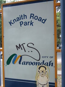 Ringwood and District Historical Society
Photograph, Knaith Road Park, Ringwood East, sign in January 2007
City of Maroondah -
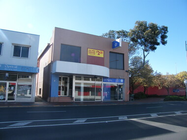 Ringwood and District Historical Society
Photograph, Looking east from 2-6 Ringwood Street, near Maroondah Highway intersection on right, in 2008. Former Post Office was located where the small park is located (on right)
Photographic record by Russ Haines, RDHS, in 2008. -
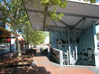 Ringwood and District Historical Society
Photograph, Civic Place, Ringwood in 2008, next to Midway Arcade. Showing stairs down to the car park
Photographic record by Russ Haines, RDHS, in 2008. -
 Ringwood and District Historical Society
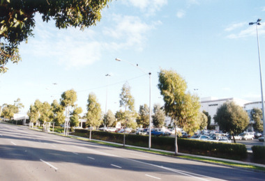
Photograph, Eastland, Ringwood in June 2002, from Warrandyte Road, Ringwood facing west, over the former car park. Showing Safeway (far left) and Myer (right)
Photographic record by Russ Haines, RDHS, in October 2008. -
 Ringwood and District Historical Society
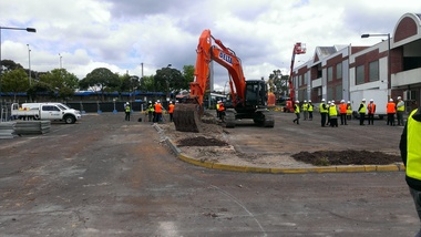
Photograph, Removal of car park at former Adelaide Street, Ringwood. Preparation for construction work beginning at the Ringwood Railway Station and Stage 5 of Eastland circa 2014
Photographs taken by Terry Ahern in 2008-2014, member of RDHS -
 Ringwood and District Historical Society
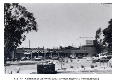
Photograph, Officeworks at the corner of Maroondah Highway and Warrandyte Road. Opening sale on 4 December 1994. Looking east over the Eastland car park
-
 Ringwood and District Historical Society
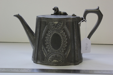
Teapot, Antimony-based Britannia metal teapot - only display item recovered from replica Antimony Miner's Hut destroyed by fire at Ringwood Lake Park circa 2006, <1860
This teapot was donated to the Historical Society and placed in the Miner's Cottage display where it remained for several years. It was removed for cleaning and put in an archives display cabinet. The miner's cottage burnt down and thus the teapot is the only remaining object from the site.Teapot made of Britannia metal. Oval with recumbent dog on top. Insulated handle. Brilliant cut design on sides. Pouring spout and '7' shaped handle.On base: 8 Warranted best Britannia metal. Sheffield. 1204