Showing 112722 items
matching tracks/roads
-
 Greensborough Historical Society
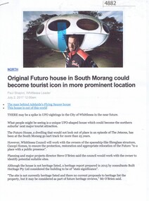
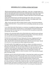
Article - Website, Paul Shapiro, Original Futuro house in South Morang, by Paul Shapiro, 02/07/2017
Of Finnish design, the building has been used as a sales booth at the Apollo Parkways estate, and moved to the TUKE Go-Kart Track on McDonalds Road South Morang, where it is being used as a storage building.3 p. text and col. and black and white photographs (digital reprint of original publication)futuro house, apollo parkways -
 Melbourne Tram Museum
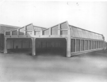
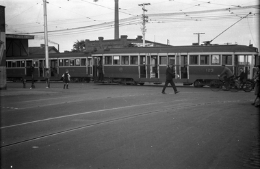
Photograph, Sutcliffe Pty Ltd, Essondon Tram Depot - new building, June 2024
The photograph is of the six road extension built on the south side of the previous depot building at Essendon. Tracks and overhead are yet to be installed - the foreground of the photograph appears to have been "photoshopped". The photograph is about June 1924.Yields information about the second shed at Essendon Depot.Black and white photograph with photographers stamp on rear.Has the stamp of "Sutcliffe Pty Ltd" on rear.trams, tramways, depot, essendon depot, new buildings -
 Melbourne Tram Museum
Pamphlet, Public Transport Victoria (PTV), "Tram service changes route 72", April 2022
Issued for track renewal in Malvern Road between Chapel St and Mandeville Crescent, Armidale between 29 April and 14 May 2022. Gives details of the replacement and alternative bus routes. Produced by the PTV.Yields information about track work in Malvern Road during 2022.Pamphlet - full colour DL 5 fold.trackwork, tramways, malvern road, route 72 -
 Melbourne Tram Museum
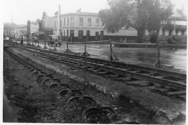
Photograph - Cable tram track removal Abbotsford St, 1935
Photograph of track reconstruction of conversion of the cable to electric tramway in Abbotsford near the corner with Canning St, about August 1935. .1 - has the old cable track excavated before the yokes were cut of and the new track - rails and sleepers laid on the previous road bed. In the background is the Homebush Hotel. In the background is a shop advertising Robur Tea. .2 - similar photo but looking along the line of yokes. with the building on the east side which have all since undergone two demolitions. The former hotel building remains but has been converted to set of apartments.Yields information about the removal of cable tram track in Abbotsford St North Melbourne.Set of two Black & White Photographs. Two copies of each held.Has the TMSV Sales stamp on the rear.trams, tramways, cable trams, abbotsford st, conversion -
 Marysville & District Historical Society
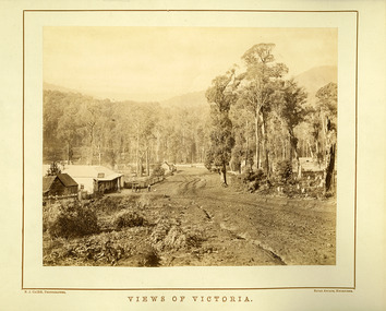
Photograph (Item) - Black and white photograph, Nicholas John Caire, Views of Victoria, Unknown
An early black and white photograph of the main road in Marysville in Victoria taken by Nicholas John Caire.An early black and white photograph of the main road in Marysville in Victoria showing the Keppels Australian Hotel which was built and opened by the Keppel Family in 1865. The Keppels Australian Hotel was the first hotel to be opened in Marysville. The Keppel Family were among Marysville's earliest pioneering families. This photograph was taken by Nicholas John Caire. N.J. Caire had a great love for the area in and surrounding Marysville and in the late 1800's took many photographs of Marysville and its surrounds. N.J. Caire was born in 1837 in Guernsey. He arrived in Adelaide about 1860 along with his parents who encouraged his early interest in photography. He opened a studio in Adelaide in 1867 after traveling extensively throughout the Gippsland taking photographs. After marrying in 1870 he moved to Talbot in Victoria until 1876 when he opened a studio in the Royal Arcade in Melbourne. After 1885 N.J. Caire gave up his city work and made his home in South Yarra and devoted the rest of his life to outdoor photography, specializing in the bush, the gullies and the mountains of south-eastern Victoria. N.J. CAIRE, PHOTOGRAPHER ROYAL ARCADE, MELBOURNEmarysville, victoria, keppels australian hotel, keppel family, nicholas john caire, photograph -
 Marysville & District Historical Society
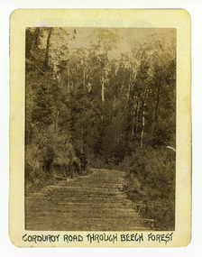
Photograph (Item) - Black and white photograph, Corduroy Road Through Beech Forest, c1900
An early black and white photograph of a corduroy road running through the forest near Marysville in Victoria.An early black and white photograph of a corduroy road running through the forest near Marysville in Victoria. A corduroy road (or log road) is a type of road or timber trackway made by placing logs, perpendicular to the direction of the road over a low or swampy area. The result is an improvement over impassable mud or dirt roads, yet rough in the best of conditions and a hazard to horses due to shifting loose logs.ARMSTRONG COLLECTION 42 STATION STREET/ SANDRINGHAM 3191/ TEL. (03) 9521 5442/ IAN M.L. ARMSTRONG OAMcorduroy road, marysville, victoria, beech forest -
 Marysville & District Historical Society
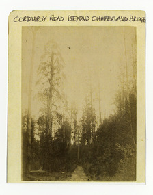
Photograph (Item) - Black and white photograph, Corduroy Road Beyond Cumberland Bridge, c1900
An early black and white photograph of a corduroy road running through the forest near Marysville in Victoria.An early black and white photograph of a corduroy road running through the forest near Marysville in Victoria. A corduroy road (or log road) is a type of road or timber trackway made by placing logs, perpendicular to the direction of the road over a low or swampy area. The result is an improvement over impassable mud or dirt roads, yet rough in the best of conditions and a hazard to horses due to shifting loose logs.ARMSTRONG COLLECTION 42 STATION STREET/ SANDRINGHAM 3191/ TEL. (03) 9521 5442/ IAN M.L. ARMSTRONG OAMcorduroy road, marysville, victoria -
 Melbourne Tram Museum
Postcard - X 217 Dandenong Road, Nucolorvue Publishing, 1974
Colour postcard of X class Birney tram 217 in Dandenong Road, 17/2/1974. Has details of the tram on the rear. Produced by Nu-color-Vue - NCV 1390. This tram is on display at the Melbourne Tram Museum - Hawthorn Depot - see reference.Yields information about X 217Postcard colour serrated edges, X 217 Dandenong Road Nu-Color-Vuetrams, tramways, tram 217, x class tram, dandenong road -
 Whitehorse Historical Society Inc.
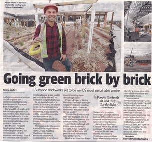
Article, Going Green Brick By Brick, 18/11/2019
Burwood Brickworks has been transformed into an environmentally sustainable shopping centre.Burwood Brickworks has been transformed into an environmentally sustainable shopping centre at 78 Middleborough Road, Burwood East and will open on 6 Dec 2019.Burwood Brickworks has been transformed into an environmentally sustainable shopping centre. brickworks, environmental management, middleborough road burwood east no 78 -
 City of Kingston
Pamphlet - Colour, Stillwell and Co, Cheltenham Charman Estate Realising Auction, 1921
Sales plan for land in the suburb of Cheltenham, along Charman Road and Weatherall Street.The developing urban area of Cheltenham within the City of Kingston. This land sale pamphlet illustrates the subdivision of land within the municipality and the changing demographic of the district as new houses are constructed.Colour pamphlet advertising realising auction of the Charman Estate, Cheltenham. Incorporates a map of the estate, showing subdivisions along Charman Road and Weatherall Street.land sales, cheltenham, estate -
 Whitehorse Historical Society Inc.
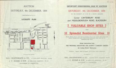
Pamphlet - Auction Flyer, Yeo, Crosthwaite & Co, Corner Canterbury Road and Middleborough Road, 4th December 1954
A green folded pamphlet advertising the sale of by auction of a shop and residential sites on the corner of Canterbury and Middleborough Roads, Blackburn on Saturday, 4 December 1954.A green folded pamphlet advertising the sale of by auction of a shop and residential sites on the corner of Canterbury and Middleborough Roads, Blackburn on Saturday, 4 December 1954.non-fictionA green folded pamphlet advertising the sale of by auction of a shop and residential sites on the corner of Canterbury and Middleborough Roads, Blackburn on Saturday, 4 December 1954.canterbury road blackburn, beck street, middleborough road blackburn, marion court, amery avenue, janet street, duckham street -
 Ringwood and District Historical Society
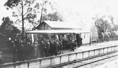
Photograph, Opening Heathmont Railway Station in May 1926, 1926
Opening Heathmont Railway Station in May 1926. The photo shows the audience, including Bill Everard MLA, at the entrance to the railway platform. The Station building was located on the west side of the tracks, near the corner of Heathmont and Canterbury Roads. At the officially opening, the ribbon was cut by Louise Pump, wife of Herman. -
 Kew Historical Society Inc
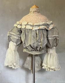
Clothing - Grey silk and lace bodice, 1875
Alice Frances (Henty) Hindson's grey silk bodice is believed to be part of her 'going-away' outfit after her wedding to John Hindson on 15 April 1875. The bodice must have been a family favourite as it was used and amended over the years. Alice was the youngest daughter of Francis Henty and Mary Ann (Lawrence) Henty. Alice's father, Francis Henty, was the youngest son of Thomas Henty, who with his family, their retainers and property moved to the Australian colonies between 1829 and 1832. In 1834, Francis’ older brother, Edward, sailed from Launceston in Van Diemen’s Land to what was to become Portland in the western part of Port Phillip District [Victoria]. Francis, together with the first flock of Merino sheep [in Victoria], followed some months later. The first and second generations of the Henty family established vast pastoral properties in the Western part of the Port Phillip District. Francis Henty managed ‘Merino Downs’ near Casterton, while also living in his retirement at ‘Field Place' in Kew. The Henty Collection of nineteenth and twentieth century clothing, including outerwear and underwear, was collected, stored and exhibited over time by female family members descended from Francis and Mary Ann Henty. During the twentieth century, items from the collection were modelled in two fashion parades by various descendants [1937, 1959]. The items in the collection are historically and aesthetically significant, with provenance provided by oral and written tradition within or held by the family. A number of the items in the collection are very rare survivors, and provide researchers with the evidence needed to reconstruct the lives of notable women in the Port Phillip District [later Victoria] during the nineteenth and early twentieth century.The yoke is a bustier bodice, made of silk and silk organza with an insert of hand-tatted lace. The bodice is carefully boned and has a little padding in the bust line. It includes the name of the maker of the bodice as ‘Madame Jay, Brighton, 38 London Road’. The silk organza sleeves have hand shirring, trim, and frilled cuffs. The bodice is finished with a large, frilled bow at the back. Believed by the Henty family to be part of the ‘going away’ outfit worn by Alice Henty in 1875. Measurements (mm): BODICE: Girth - Neck 304.8, Chest 762, Waist 571.5, Cuff 127 Vertical - From neck to hem 381, Front waist to hem 152.4, Back neck to hem 419.1, Back waist to hem 228.6, Sleeve length 254. Horizontal - Neck to sleeve head 165.1, Cross back 457.2, Underarm to underarm 431.8.Mme Jay, Brighton Road, London [dressmaker]bodices, women's clothing, alice (henty) hindson, alice francés henty -
 Whitehorse Historical Society Inc.
Document - E G GREENWAY PTY LTD, E G GREENWAY PTY LTD Pottery Factory, 1947 - 1949
A pottery factory at 129 Whitehorse Road, Blackburn. Became the PMG mail sorting centre and is now a Sikh Temple, GURUDWARAnon-fictione g greenway pty ltd, gurudwara sikh, postal services -
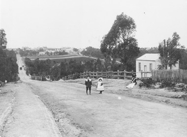 Ringwood and District Historical Society
Photograph, Addison home 1902 Ringwood in background
Black and white photograph of scene showing unmade road with two children, a boy and a girl standing outside a small wooden building. Lady is sitting by the side of road. Road dips down to a bridge then rises again towards distant settlement in background. (3 copies)Typed below enlarged photo, "Addison home, 1902 - Opposite present St. Paul's, Warrandyte Road". Written on backing sheet, "Andersons Creek Rd. 1903. Mrs. Addison (Annie Kennedy) and family - Annie, born 1897 and William. Their house at right was on a 5 acre block. Ringwood in background". Backing sheet of another copy reads, "Andersons Creek Road 1902 (Warrandyte Rd. looking south). Mrs. Addison (Annie Kennedy) and family. Annie (Jnr), born 1897 and Samuel John James William, born 1894. Their home, at right, was on a 5 acre block. Ringwood in background - burned down by pet magpie. T. Grant's land ploughed - now Eastland. Adelaide St. seen on right of it. Mullum Creek Bridge at foot of hill". Typed below this photograph, "Warrandyte Rd. Ringwood looking south from near Mullum Rd. Ringwood in background. Maroondah Highway at top of hill with Mullum Creek bridge seen in dip - 1902". -
 Kew Historical Society Inc
Photograph, Wade's Farm, Kilby Road, Nineteenth Century
""The public trial of reaping machines, under the auspices of the Port Phillip Farmers' Society, advertised to take place on Friday, last, but postponed on account of the weather, came off December 27. The place selected (Mr. Wade's farm, Belford, near Kew) is undulating ground, with a remarkably heavy crop of wheat upon it. This, taken in connection with, the state of the ground, still soft from the recent rains, made the trial an uncommonly severe one. ..."(South Australian Advertiser, 15 January 1859) Some bricks used in Kew buildings came from the brickworks on Wade's Farm at the end of Belford Road near the Yarra River (now part of the Kew Golf Club). (History of RSL by John Torpey)Wade's Farm, Kilby Road, Kew.wade's farm, farming (kew), kilby road, north kew, belford road, kew, kew golf club -
 Melbourne Tram Museum
Slide - Set of 7, Keith Caldwell, 17/06/1971 12:00:00 AM
Set of seven Agfa colour slide, blue and white plastic mount, photo by Keith Caldwell of a track deviation during the construction of the Alexandria Avenue underpass at the north end of St Kilda Road. Shows the deviation, temporary track ("on the fly), overhead works and after the bridge has been completed, the permanent track brought into use.. All have the Arts Centre in the background. Slides 1 to 4 - 17/6/1971, 5 to 7 - 20/6/1971, after the change over from the temporary track to the permanent track. .1 - W6 919 outbound, East Malvern Route 3 - has a large gantry beam in the background and an advertisement for briquettes and Norton Bear tape. In the background is the National Gallery of Victoria building. .2 - W2 819 outbound, route 8 Toorak, with Shrine of Remembrance in the background. .3 - W2 389 ditto for Glen Iris, Route 6 .4 - W2 349 outbound for East Brighton, route 64 and inbound W2 633, city, route 67. .5 - SW6 854 inbound using the new track on the bridge, but temporary track remains in front of the tram. Overhead crews at work. W5 768 following. Both trams are travelling on the wrong line or "bang road" Tram have a Stillwell Ford and Ferris Car radio adverts. .6 - SW6 905 inbound, route 67. Also running wrong line. In the background is a rail mounted overhead trolley tower and Bedford truck MZR129. .7 - SW6 845 in bound route 8 followed by SW6 854, route 72. Both trams are running on the wrong line. An excavator in the background is working on removing the deviation track. 845 has various adverts including one for Uniroyal Tyres..1 has in pencil "17.6.71" and "Alex Av Opass constrn" and .7 "20.6.71"trams, tramways, st kilda rd, temporary track, trackwork, overhead, alexandra ave, princes bridge, bridges, route 3, route 67, route 64, route 8, route 6, route 72, w6 class, w2 class, tram 919, tram 905, tram 819, tram 389, tram 349, tram 633, tram 854, tram 768, tram 845, tram 854 -
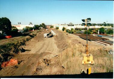 Hume City Civic Collection
Photograph, 21/04/2005
This photograph was taken during the upgrade of the Bendigo Railway line at Sunbury Station. The upgrade of the line took over twelve months to complete and bus services replaced the train service during that time.A coloured photograph of construction on the site of the Sunbury Railway Station. The photograph has been taken from the Macedon Street bridge and is looking south towards Station Street. The old rail tracks have been removed and excavation work is in progress to make way for the new tracks. The new rail lines have been placed on the side of the track on the RHS of the photograph.railways, bendigo line, railway stations, bridges, sunbury railway station, george evans collection -
 Orbost & District Historical Society
book, Broadbent's Melbourne - Sydney Guide Book, 1936
Broadbent's Official Road Guides Company took over George R. Broadbent's business in 1935. In 1963, it changed its name to Broadbent's Road Maps Pty. Ltd. George Robert Broadbent (1863-1947), cyclist and map publisher, was born on 3 November 1863 at Ashby near Geelong, Victoria. At various times Broadbent held most Victorian and Australian road cycling records. Broadbent became an active vice-president of the Good Roads Association of Victoria in November 1912 and was consulted regularly during the preparation of the country roads bill. That year he took over the Argus motoring column, wrote tirelessly on road improvements and maintenance, and became manager of the Automobile Club's new touring department in 1914.A 160 pp road guide book titled Broadbent's Official Road Guide Melbourne - Sydney. The front cover has a yellow background with a map of the coastline from Sydney to Melbourne, the Prince's Highway route marked. This is inset in a drawing of a car driving along the coastal road.The book contains speedometer readings, route maps, advertisements and photos of points of interest. In the top right is the logo of the Royal Automobile Club of Victoria and at the bottom right is the price 1/-.traavel road-guides broadbent-george car-touring -
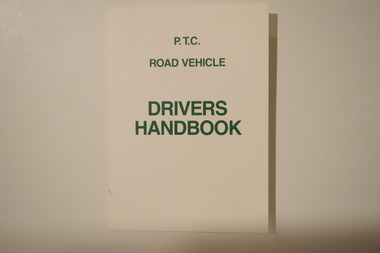 Melbourne Tram Museum
Booklet - PTC Road Vehicle Drivers Handbook, Public Transport Corporation (PTC), c.1990s
Handbook for PTC road vehicle drivers. The booklet contains important information for drivers concerning multiple aspects of operating a motor vehicle (e.g., buses).Instructional publication belonging to a now-superceded transit agency (since the 1990s). Likely well-used by staff of said agency.A small off-white booklet printed with green text. The front cover reads "P.T.C./ROAD VEHICLE/DRIVERS/HANDBOOK."public transport corporation, public transport, buses, drivers, driver training -
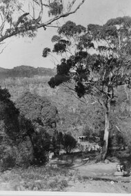 Halls Gap & Grampians Historical Society
Photograph - B/W, C ?
... Roads ...This is the ford over the Stoney Creek and shelter shed.The photo shows a track leading down to a large pergola type structure, surrounded by thick bush. There is a tall gum on the right of the picture, beside the track. A large branch of a tree can be seen in the top left foreground.access routes, roads -
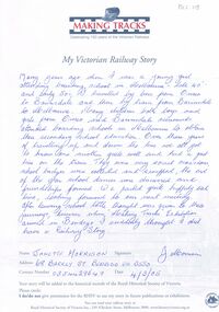 Bendigo Historical Society Inc.
Document - BADHAM COLLECTION: MAKING TRACKS - MY VICTORIAN RAILWAYS STORY ESSAY
Making tracks: My Victorian Railways Story, essay submitted by Janette Morrison, 68 Barkly St Bendigo. Foolscap paper with Making Tracks logo on top of the page. Publication of the Royal Historical Society of Victoria.document, memo, railway, making tracks - my victorian railways story essay janette morrison making tracks logo - publication of royal historical society of victoria. printed by, printers proprietary ltd., 27 little bourke st., melbourne. -
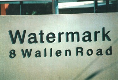 Melbourne Tram Museum
Photograph - Set of 9 Colour Print/s, Steven Altham, 27/02/2002 12:00:00 AM
Set of 9 colour prints of the re construction of the Hawthorn Tram Depot to the Watermark Apartments. All taken on 20-9-2002 .1 - The Watermark sign with address .2 - View from looking south with car park entrance. .3 - view from Wallen road looking towards the depot and with overhead up. .4 - Original depot with one of the doors opened. .5 - ditto with the facade of the 5 to 7 roads. .6 - view from Wallen road showing track fan. .7 - view of the building along Wallen Road from west end. .8 - view from the parkland looking north. .9 - ditto.All have details of photograph on rear and photographers name.trams, tramways, watermark apartments, hawthorn depot, construction, tram depot -
 Melbourne Tram Museum
Negative, Wal Jack collection, 24/11/1941 12:00:00 AM
Black and white negative by Wal Jack of Maximum Traction N 123 northbound in Nicholson St at the intersection with Holmes Road and Moreland Road. W2 445 has the destination of Darling Road. The tracks into Moreland Road are in the foreground. A RAAF poster can be seen in one of the windows of both cars. Note the fire alarm pillar, the paper boy, conductor on the step of the N 123. A premise selling blankets, sheets and towels etc can be seen. See also Reg Item 5328 to 5332 for other photos featuring this tram. Photo not in the album, based on the date of others featuring N123, 24/11/1941.trams, tramways, n class, w2 class, coburg, moreland rd, nicholson st, tram 123, tram 445 -
 Melbourne Tram Museum
Slide - Set of 6, Warren Doubleday, 9/03/1970 12:00:00 AM
Set of 6 Colour slides- Anscochrome plastic mount taken on 9-3-1970 of the shunting of trams for the Moomba Parade in Sturt St and City Road, prior to the deviation of the tracks to go around the Arts Centre. .1 - W2 631 in turning into City Road from Sturt St .2 - W2 629 turning from St Kilda Road, in to City Road .3 - W2 639 and 550 in Sturt St .4 - W2 550 - route 64, City in Sturt St .5 - W2 629,SW6 898 and 322, Sturt St. .6 - W2 641, 387 and others Sturt St.Has slide number written on itemtrams, tramways, city road, sturt st, moomba, parades, st kilda road, w2 class, tram 611, tram 629, tram 639, tram 550, tram 898, tram 322, tram 641, tram 387 -
 Ballarat Tramway Museum
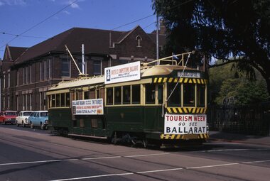
Slide - 35mm slide/s, Keith Kings, Ballarat No. 36, Domain Road for Tourism Week, 23/09/1971 12:00:00 AM
Yields information about tram 36 when it was used in Melbourne following closure of the Ballarat SEC system for tourist promotion.Colour 35mm slide in a Kodachrome cardboard mount of Ballarat No. 36, after closure of the Ballarat system, in Melbourne, Domain Road for Tourism Week, promoting Ballarat. See Reg item 3501 for photos of its transport to Melbourne and 3432 for a newspaper clipping and 3546 and 3503 for other photos in the same location. Photo shows details of the banners and roof advertisements. Has destination of Sebastopol. Photo from the collection of Lilian Butler.Written around the slide in in k "Ballarat - K. S. Kings No. 90-36, 23/9/1971, and No. 36 running in Melbourne as arranged by the Tourist Development Authority in Domain Road at St Kilda Road.tramways, trams, melbourne, tourism, mmtb, tmsv, domain road, tram 36 -
 Glen Eira Historical Society
Album - Album page, Glen Huntly Road, Circa 1972
This photograph is part of the Caulfield Historical Album 1972. This album was created in approximately 1972 as part of a project by the Caulfield Historical Society to assist in identifying buildings worthy of preservation. The album is related to a Survey the Caulfield Historical Society developed in collaboration with the National Trust of Australia (Victoria) and Caulfield City Council to identify historic buildings within the City of Caulfield that warranted the protection of a National Trust Classification. Principal photographer thought to be Trevor Hart, member of Caulfield Historical Society. Most photographs were taken between 1966-1972 with a small number of photographs being older and from unknown sources. All photographs are black and white except where stated, with 386 photographs over 198 pages. From: Glen Eira Heritage Management Plan (1996) by Andrew Ward and Associates Moore's Buildings", were built in 1891 and comprising 5 shops. In 1888, Hugh Moore, a gentleman, subdivided his land in Glen Huntly Road, north side between Selwyn Street and St Georges Road into 27 lots, with a right of way separating them from his property "Glenmoore". The subdivision was known as the "Glenmoore Estate". Purchases of land included local builders Corkill, French and Pugh. Moore retained five lots and W.W. Jamieson bought lots 11 to 14. "Moore' s Buildings are locally important for their association with the early Elsternwick land owner, Hugh Moore, whose home, "Glenmoore", at 1 St.Georges Road (qv) survives. They recall Elsternwick's role in the Land Boom and survive as a most prominent row in the Glen Huntly Road shops, enhanced by the survival of the unpainted stuccoed surfaces to nos. 307-311. 287-289 Glen Huntly Road: contributory to HO72, Elsternwick Estate and Environs, City of Glen Eira.Page 63 of Photograph Album with one landscape photograph of retail shops (Moore's Buildings).Hand written: 287-289 Glen Huntly Road [under photo] / 63 [bottom left] trevor hart, shop, grocer, stuccoed, terrace, victorian terrace, protruding parapet, ornate render, hugh moore, 1890's, moore's buildings, glenmoore, glenmoore estate, shopping centres, milk bars, cars, victorian style, glen huntly road, glenhuntly road, elsternwick -
 Marysville & District Historical Society
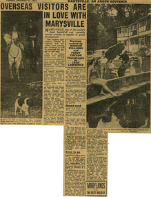
Newspaper (Item) - Newspaper article, The Argus Newspaper et al, Overseas visitors are in love with Marysville, 06-12-1955
A digital copy of a newspaper article regarding the need for the government of the time to make improvements on roads and to infrastructure at tourist sites in the Marysville area.A digital copy of a newspaper article regarding the need for the government of the time to make improvements on roads and to infrastructure at tourist sites in the Marysville area.Souvenir/ written by/ GORDON/ WILLIAMS/ and/ PERCY/ TAYLOR/ Photography/ by/ JACK/ LAWRENCEmarysville, victoria, newspaper article, the argus, jack lawrence, gordon williams, percy taylor, marysville tourist and progress association, lake mountain, steavenson falls, talbot drive, keppel falls, taggerty river -
 Whitehorse Historical Society Inc.
Document, Growing Up At 1 Vernal Avenue, 1947 - 1962
Childhood memories of Jenny Brash & her neighbours. She grew up at 1 Vernal Avenue, Mitcham and later Glenburnie Road.Childhood memories of Jenny Brash & her neighbours as she grew up at 1 Vernal Avenue, Mitcham and later Glenburnie Road.Childhood memories of Jenny Brash & her neighbours. She grew up at 1 Vernal Avenue, Mitcham and later Glenburnie Road.vernal avenue mitcham no1, brash jenny, orient avenue mitcham, wills jack, wills victor, glenburnie road mitcham no25 -
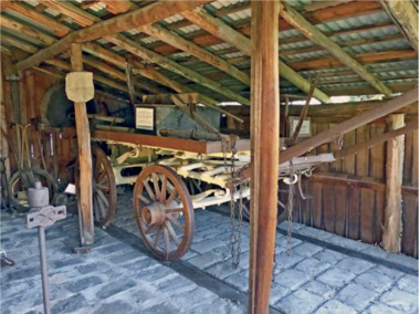 City of Moorabbin Historical Society (Operating the Box Cottage Museum)
Functional object - Plateway horse-drawn wagon, c. 1883
... roads ...This Plateway Wagon was built by Pengelly's Carriage Works, North Brighton 1883. The wagon was owned by the Corrigan family, market gardeners in Noble Park. It is an original, timber horse-drawn wagon that used the the Plateway or Wheelway from 1890. These heavily laden market gardener’s carts could travel relatively smoothly and safely, along the steel rails on the main roads of Moorabbin Parish to Melbourne and St Kilda markets to sell their produce, at a time when the road surfaces were rutted and hazardous.After the Henry Dendy Special Survey of the Parish of Moorabbin in 1841, land was sold to pioneer settlers who developed market gardens, vineyards and fruit gardens ( orchards ). These market gardeners took their produce in heavily laden horse-drawn Wagons along the steel Plateway to the markets in St Kilda and Melbourne. An original, timber horse-drawn wagon of a type that used the Plateway or Wheelway. The steel rails of the Plateway played such an important role from the 1890’s in the transportation of produce along the City of Moorabbin’s major roads, (including Centre Road, Bentleigh), to reach the markets in St Kilda and Melbourne. Heavily laden market gardener’s carts , drawn by a horse, could travel relatively smoothly and safely, along the steel rails to city markets, at a time when the road surfaces were rutted and hazardous. horse, melbourne, brighton, moorabbin, steel, henry, dendy, fruit, gardens, roads, plateway, wheelway, bentleigh, vineyards, orchards, draught, markets, st kilda, wagons