Showing 4870 items
matching ballarat post office
-
 Ballarat Heritage Services
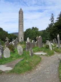
Photograph - Colour, St Kevin's, Ireland, 2016, 2017
Colour photograph of St Kevin's, Ireland. ireland, st kevin's -
 Ballarat Heritage Services
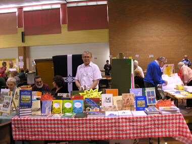
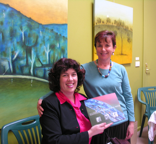
Photograph - Colour, Wayne Phillipson at the Bendigo Open Day, 2004, 01/01/2004
... Ballarat Heritage Services PO Box 2209 Bakery Hill Post ...Wayne Phillipson with the Ballarat Heritage Services Publication Display at the Bendigo Open Day.wayne phillipson, ballarat heritage services, bendigo open day -
 Ballarat Heritage Services
Photograph - Colour, Old Sarum, England, 2017, 01 November 2016
William the Conqueror inherited Old Sarum from the last Saxon king of England. It was an ideal site for a royal castle. It was here in 1070 that William paid off his army after a long and bitter campaign in northern England. It was here in 1086 that he called together all the major landholders in England so they could swear allegiance to him. It was a crucial moment. The Domesday Book was being written, a threatened Viking invasion had only just been averted and William's eldest son was in armed rebellion. Old Sarum was an important place where this Norman king of England held power. In 1794 the Ordnance Survey set out to check the accuracy of the first mapping of Southern England, which had begun ten years earlier. From a point just below Old Sarum Lieutenant William Mudge laid out a base-line 36,574 feet (11,253 metres) long. From each end of the line the positions of distant places were plotted using a huge theodolite made in 1791 by Jesse Ramsden. The accuracy of the process, which was repeated all over England, depended on Jesse Ramsden's craftsmanship and on William Mudge's surveying skill in setting out this first base-line from Old Sarum. The nearer end of Mudge's line is marked by an inscribed stone beside the modern A345 at Old Sarum. ordnance survey, william mudge, jesse ramsden, william the conqueror, old sarum, saxon, 1086, england -
 Ballarat Heritage Services
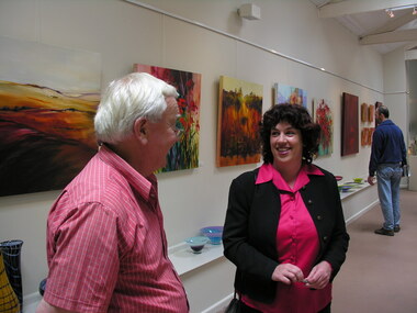
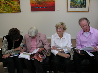
Photograph - Colour, Launch of "Bullboar, Macaroni and Mineral Water: Spa Country's Swiss and Italian Story", 2005, 17/12/2005
Graham Hudson (Righetti) and Clare Gervasoni at the launch of "Bullboar, Macaroni and Mineral Water: Spa Country's Swiss and Italian Story" at the Pantechnicon Art Gallery, Daylesford.swiss/italian, swiss and italian, clare gervasoni, graham hudson, bullboar, macaroni and mineral water -
 Ballarat Heritage Services
Photograph - Colour, Launch of "Bullboar, Macaroni and Mineral Water: Spa Country's Swiss and Italian Story", 2005, 17/12/2005
Graham Hudson (Righetti) and Clare Gervasoni at the launch of "Bullboar, Macaroni and Mineral Water: Spa Country's Swiss and Italian Story" at the Pantechnicon Art Gallery, Daylesford.swiss/italian, swiss and italian, clare gervasoni, graham hudson -
 Ballarat Heritage Services
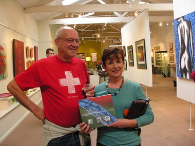
Photograph - Colour, Launch of "Bullboar, Macaroni and Mineral Water: Spa Country's Swiss and Italian Story", 2005, 17/12/2005
Jon Stevens and Cr Heather Mutimer at the launch of "Bullboar, Macaroni and Mineral Water: Spa Country's Swiss and Italian Story" at the Pantechnicon Art Gallery, Daylesford.swiss/italian, swiss and italian, clare gervasoni, jon stevens, heather mutimer, bullboar -
 Ballarat Heritage Services
Photograph - Colour, Launch of "Bullboar, Macaroni and Mineral Water: Spa Country's Swiss and Italian Story", 2005, 17/12/2005
Author Clare Gervasoni and Cr Heather Mutimer at the launch of "Bullboar, Macaroni and Mineral Water: Spa Country's Swiss and Italian Story" at the Pantechnicon Art Gallery, Daylesford.swiss/italian, swiss and italian, clare gervasoni, heather mutimer, bullboar, macaroni and mineral water -
 Ballarat Heritage Services
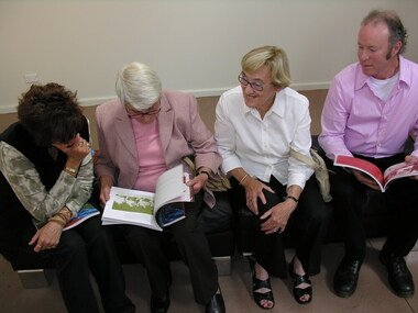
Photograph - Colour, Launch of "Bullboar, Macaroni and Mineral Water: Spa Country's Swiss and Italian Story", 2005, 17/12/2005
Swiss and Italian descendants (Perini) check out the new book at the launch of "Bullboar, Macaroni and Mineral Water: Spa Country's Swiss and Italian Story" at the Pantechnicon Art Gallery, Daylesford.swiss/italian, swiss and italian, clare gervasoni -
 Ballarat Heritage Services
Photograph - Photograph - Colour, Old Sarum, England, 2016, 01/11/2016
William the Conqueror inherited Old Sarum from the last Saxon king of England. It was an ideal site for a royal castle. It was here in 1070 that William paid off his army after a long and bitter campaign in northern England. It was here in 1086 that he called together all the major landholders in England so they could swear allegiance to him. It was a crucial moment. The Domesday Book was being written, a threatened Viking invasion had only just been averted and William's eldest son was in armed rebellion. Old Sarum was an important place where this Norman king of England held power. In 1794 the Ordnance Survey set out to check the accuracy of the first mapping of Southern England, which had begun ten years earlier. From a point just below Old Sarum Lieutenant William Mudge laid out a base-line 36,574 feet (11,253 metres) long. From each end of the line the positions of distant places were plotted using a huge theodolite made in 1791 by Jesse Ramsden. The accuracy of the process, which was repeated all over England, depended on Jesse Ramsden's craftsmanship and on William Mudge's surveying skill in setting out this first base-line from Old Sarum. The nearer end of Mudge's line is marked by an inscribed stone beside the modern A345 at Old Sarum. Colour photograph of Old Sarum, England.ordnance survey, william mudge, jesse ramsden, william the conqueror, old sarum, saxon, 1086, england -
 Ballarat Heritage Services
Photograph - Colour, Launch of "Bullboar, Macaroni and Mineral Water: Spa Country's Swiss and Italian Story", 2005, 17/12/2005
Swiss and Italian descendants (Perini) check out the new book at the launch of "Bullboar, Macaroni and Mineral Water: Spa Country's Swiss and Italian Story" at the Pantechnicon Art Gallery, Daylesford.swiss/italian, swiss and italian, clare gervasoni, marie butler -
 Ballarat Heritage Services
Photograph - Colour, Earth Banks, Old Sarum, England, 01 November 2016
William the Conqueror inherited Old Sarum from the last Saxon king of England. It was an ideal site for a royal castle. It was here in 1070 that William paid off his army after a long and bitter campaign in northern England. It was here in 1086 that he called together all the major landholders in England so they could swear allegiance to him. It was a crucial moment. The Domesday Book was being written, a threatened Viking invasion had only just been averted and William's eldest son was in armed rebellion. Old Sarum was an important place where this Norman king of England held power. In 1794 the Ordnance Survey set out to check the accuracy of the first mapping of Southern England, which had begun ten years earlier. From a point just below Old Sarum Lieutenant William Mudge laid out a base-line 36,574 feet (11,253 metres) long. From each end of the line the positions of distant places were plotted using a huge theodolite made in 1791 by Jesse Ramsden. The accuracy of the process, which was repeated all over England, depended on Jesse Ramsden's craftsmanship and on William Mudge's surveying skill in setting out this first base-line from Old Sarum. The nearer end of Mudge's line is marked by an inscribed stone beside the modern A345 at Old Sarum. ordnance survey, william mudge, jesse ramsden, william the conqueror, old sarum, saxon, 1086, england -
 Ballarat Heritage Services
Photograph - Colour, Dorothy Wickham, Earth Banks, Old Sarum, England, 2016, 01 November 2016
William the Conqueror inherited Old Sarum from the last Saxon king of England. It was an ideal site for a royal castle. It was here in 1070 that William paid off his army after a long and bitter campaign in northern England. It was here in 1086 that he called together all the major landholders in England so they could swear allegiance to him. It was a crucial moment. The Domesday Book was being written, a threatened Viking invasion had only just been averted and William's eldest son was in armed rebellion. Old Sarum was an important place where this Norman king of England held power. In 1794 the Ordnance Survey set out to check the accuracy of the first mapping of Southern England, which had begun ten years earlier. From a point just below Old Sarum Lieutenant William Mudge laid out a base-line 36,574 feet (11,253 metres) long. From each end of the line the positions of distant places were plotted using a huge theodolite made in 1791 by Jesse Ramsden. The accuracy of the process, which was repeated all over England, depended on Jesse Ramsden's craftsmanship and on William Mudge's surveying skill in setting out this first base-line from Old Sarum. The nearer end of Mudge's line is marked by an inscribed stone beside the modern A345 at Old Sarum. King William devised the Domesday Book, considered to be the first listing of land owners in England. Among the names is that of D'Arques, from Normandy, France. Descendants of this family later emigrated from England and settled in Victoria, Australia under the surname 'Dark'. ordnance survey, william mudge, jesse ramsden, william the conqueror, old sarum, saxon, 1086, england -
 Ballarat Heritage Services
Photograph - Colour, Earth Banks, Old Sarum, England, 2016, 01 November 2016
William the Conqueror inherited Old Sarum from the last Saxon king of England. It was an ideal site for a royal castle. It was here in 1070 that William paid off his army after a long and bitter campaign in northern England. It was here in 1086 that he called together all the major landholders in England so they could swear allegiance to him. It was a crucial moment. The Domesday Book was being written, a threatened Viking invasion had only just been averted and William's eldest son was in armed rebellion. Old Sarum was an important place where this Norman king of England held power. In 1794 the Ordnance Survey set out to check the accuracy of the first mapping of Southern England, which had begun ten years earlier. From a point just below Old Sarum Lieutenant William Mudge laid out a base-line 36,574 feet (11,253 metres) long. From each end of the line the positions of distant places were plotted using a huge theodolite made in 1791 by Jesse Ramsden. The accuracy of the process, which was repeated all over England, depended on Jesse Ramsden's craftsmanship and on William Mudge's surveying skill in setting out this first base-line from Old Sarum. The nearer end of Mudge's line is marked by an inscribed stone beside the modern A345 at Old Sarum. ordnance survey, william mudge, jesse ramsden, william the conqueror, old sarum, saxon, 1086, england -
 Ballarat Heritage Services
Photograph - Photograph - Colour, Castle toilets, Old Sarum, England, 2016, 01/11/2016
William the Conqueror inherited Old Sarum from the last Saxon king of England. It was an ideal site for a royal castle. It was here in 1070 that William paid off his army after a long and bitter campaign in northern England. It was here in 1086 that he called together all the major landholders in England so they could swear allegiance to him. It was a crucial moment. The Domesday Book was being written, a threatened Viking invasion had only just been averted and William's eldest son was in armed rebellion. Old Sarum was an important place where this Norman king of England held power. In 1794 the Ordnance Survey set out to check the accuracy of the first mapping of Southern England, which had begun ten years earlier. From a point just below Old Sarum Lieutenant William Mudge laid out a base-line 36,574 feet (11,253 metres) long. From each end of the line the positions of distant places were plotted using a huge theodolite made in 1791 by Jesse Ramsden. The accuracy of the process, which was repeated all over England, depended on Jesse Ramsden's craftsmanship and on William Mudge's surveying skill in setting out this first base-line from Old Sarum. The nearer end of Mudge's line is marked by an inscribed stone beside the modern A345 at Old Sarum. Colour photographs of Castle toilets at Old Sarum, England. The toilets are constructed of stone. ordnance survey, william mudge, jesse ramsden, william the conqueror, old sarum, saxon, 1086, england, subjects, toilets -
 Ballarat Heritage Services
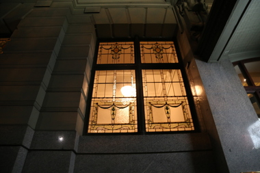
digital photographs, Rendezvous Hotel Melbourne, 2017
images of window and interior at nightheritage, hotel, stained glass, window, night -
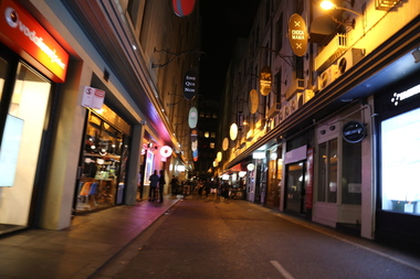 Ballarat Heritage Services
digital photographs, degraves street, 2017
heritage, melbourne, lane, laneway, restaurants, night -
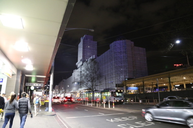 Ballarat Heritage Services
digital photographs, Lisa Gervasoni, Flinders St wrapped, 2017
heritage, melbourne, railway, station, scaffold, restoration, flinders street station -
 Ballarat Heritage Services
digital photographs, Lisa Gervasoni, Ceiling at the Rendezvous Hotel, Melbourne, 2017
heritage, melbourne, ceiling, rendezvous -
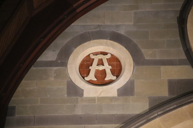 Ballarat Heritage Services
digital photographs, St Paul's - Constance Johnson's Memorial Service, 2017
heritage, melbourne, st paul's, church of england, cathedral, alpha, omega, memorial, service, constance johnson, connie johnson -
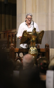
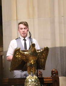 Ballarat Heritage Services
digital photographs, Lisa Gervasoni, Constance Johnson's Memorial Service at St Paul's Anglican Church, Melbourne, 2017
Colour photograph of Jimmy Harrington speaking at Constance Johnson's Memorial Service.melbourne, st paul's, church of england, cathedral, jimmy harrington, constance johnson, memorial service, love your sister, cancer charity, village, villagers -
 Ballarat Heritage Services
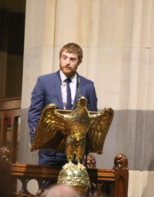
digital photographs, Lisa Gervasoni, St Paul's - Constance Johnson's Memorial Service, 2017
melbourne, st paul's, church of england, cathedral, constance johnson, memorial service, love your sister, cancer charity, village, villagers, jonathon hinton -
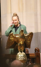
 Ballarat Heritage Services
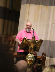
digital photographs, Lisa Gervasoni, St Paul's - Constance Johnson's Memorial Service, 2017
melbourne, st paul's, church of england, cathedral, constance johnson, memorial service, love your sister, cancer charity, village, villagers, craig coomes -
 Ballarat Heritage Services
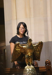
digital photographs, Lisa Gervasoni, Constance Johnson's Memorial Service at St Paul's Cathedral, Melbourne, 2017
melbourne, st paul's cathedral, church of england, cathedral, constance johnson, memorial service, love your sister, cancer charity, village, villagers, mel yeates -
 Ballarat Heritage Services
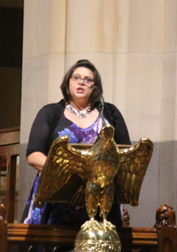
digital photographs, Lisa Gervasoni, St Paul's - Constance Johnson's Memorial Service, 2017
melbourne, st paul's, church of england, cathedral, constance johnson, memorial service, love your sister, cancer charity, village, villagers, helen ritchie -
 Ballarat Heritage Services
digital photographs, Lisa Gervasoni, St Paul's - Constance Johnson's Memorial Service, 2017
melbourne, st paul's, church of england, cathedral, constance johnson, memorial service, love your sister, cancer charity, village, villagers, louise munnoch -
 Ballarat Heritage Services
digital photographs, Lisa Gervasoni, St Paul's - Constance Johnson's Memorial Service, 2017
melbourne, st paul's, church of england, cathedral, constance johnson, memorial service, love your sister, cancer charity, village, villagers, carrie bickmore