Showing 2521 items
matching goldfield map
-
 Bendigo Historical Society Inc.
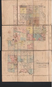
Map - JACK FLYNN COLLECTION: WOODSTOCK, 4/07/1935
... Inc. History House 11 Mackenzie Street Bendigo goldfields MAP ...Map: Parish of Woodstock, County of Bendigo. Parish plan.By Authority H.J. Green. Govt Printer. Drawn and Reproduced at the Dept of Lands and Survey, Melbourne Victoria. 4.7.35map, bendigo, parish plan, woodstock -
 Bendigo Historical Society Inc.
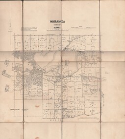
Map - JACK FLYNN COLLECTION: WARANGA, 1959
... Inc. History House 11 Mackenzie Street Bendigo goldfields MAP ...Map: Parish of Waranga, County of Rodney. Parish plan.By Authority. A.C. Brooks. Government Printer Melbourne. Drawn and Reproduced at the Department of lands and survey. Melbourne 1959.map, rodney, parish plan, waranga -
 Bendigo Historical Society Inc.
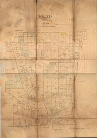
Map - JACK FLYNN COLLECTION: TOOLLEEN, 25/05.1926
... Inc. History House 11 Mackenzie Street Bendigo goldfields MAP ...Map: Parish of Toolleen, County of Rodney. Parish plan.By Authority, H.J. Green. Govt., Printer. Photo-Lithographed at the Department of Lands and Survey Melbourne. W. J. Butson 25.5.26.map, rodney, parish plan, toolleen -
 Bendigo Historical Society Inc.
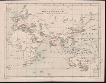
Document - KELLY AND ALLSOP COLLECTION: MAP OF P & O SHIPPING ROUTES
Document. KELLY & ALLSOP COLLECTION. Map of Europe, Africa and Asia showing the shipping routes of the Peninsular & Oriental Steam Navigation Co. Routes highlighted in red. Produced by Nissen & Arnold, Fenchurch St., London. Date estimated as early 20th century.Nissen & Arnoldbusiness, stockbroker, kelly & allsop, kelly & allsop collection, p & o map, shipping routes, nissen & arnold. -
 Bendigo Historical Society Inc.
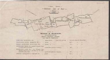
Document - KELLY AND ALLSOP COLLECTION: HUSTLERS LINE OF REEF MAP, 30/07/1891
Document. KELLY & ALLSOP COLLECTION. Map of the Hustlers Line of Reef, Bendigo (South portion). Issued by Wood & McNair, Sharebrokers, Beehive Chambers, Bendigo and High St., Eaglehawk. Mines shown on map are Fortuna Hustler's Co., Hustler's Royal Reserve No.2, Great Extended Hustlers Co., Hustlers Reef Co., Hustler's Reef No.1 Co., United Hustler's & Redan Co. Number of shares is listed against each of these mines.Wood & McNairbusiness, stockbroker, kelly & allsop, kelly & allsop collection, hustlers line of reef map, wood & mcnair. -
 Bendigo Historical Society Inc.
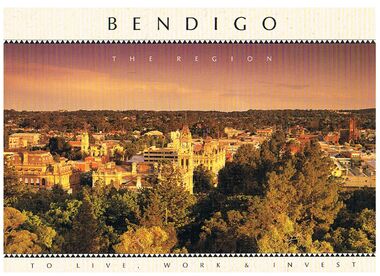
Book - BENDIGO - THE REGION TO LIVE, WORK & INVEST
Pale yellow 12 page book titled 'Bendigo the Region to Live Work & Invest'. On the front cover is a scenic view of Bendigo and on the back cover a picture of some quartz and gold nuggets on a green background. Sections in the book are: Live Work & Invest, Lifestyle, Access, Community, Infrastructure, Labour Force, Business, Opportunity, Successes and Information. Each page has a colour picture, they are:- Hargreaves Mall, Eaglehawk Golf Course, Map of Victoria, La Trobe University, Big Hill, Regional Office Department of Planning & Development, Sandhurst Farms, Construction Activity, Products of the Region, Dr. Ian Macbean, Mr Evan Jones and the Capital Theatre with information on each.book, bendigo, bendigo, bendigo - the region to live, work & invest, bendigo regional development board, dr ian macbean, mr evan jones, kate mildren, richard gibbs, express printers, hargreaves mall, eaglehawk golf course, map of victoria, la trobe university, big hill, regional office department of planning & development, sandhurst farms, construction activity, products of the region, capital theatre -
 Bendigo Historical Society Inc.
Map - KANGAROO FLAT SUBDIVISION, 26/11/1900
... Inc. History House 11 Mackenzie Street Bendigo goldfields MAP ...Map: Plan of Subdivision at Kangaroo flat, Parish of Sandhurst, County of Bendigo ( number 149 in Map Cupboard 1)map, bendigo, parish plan, kangaroo flat, parish of sandhurst, county of bendigo -
Bendigo Historical Society Inc.
Map - KANGAROO FLAT, 27/.01/1932
... Inc. History House 11 Mackenzie Street Bendigo goldfields MAP ...Map: Township of Kangaroo Flat, Parish of Sandhurst, County of Bendigo ( number 148 in Map Cupboard 1)map, bendigo, township, kangaroo flat, parish of sandhurst, county of bendigo -
Bendigo Historical Society Inc.
Map - PART PARISHES OF MANDURANG AND SANDHURST, No date visible
... Inc. History House 11 Mackenzie Street Bendigo goldfields MAP ...Map: Section of Parish plan of Bendigo covering Mandurang, Diamond Hill, and Quarry Hill, ( number 147 in Map Cupboard 1).Map 11map, bendigo, city streets, parish of mandurang, parish of sandhurst, diamond hill , quarry hill -
Bendigo Historical Society Inc.
Map - PART PARISHES OF MARONG AND LOCKWOOD, No date visible
... Inc. History House 11 Mackenzie Street Bendigo goldfields MAP ...Map: Section of Parish plan of Bendigo, covering Kangaroo Flat, Golden Square, and Specimen Hill ( number 146 in Map Cupboard 1)Map 10map, bendigo, city streets, parish of marong, parish of lockwood, kangaroo flat, golden square, specimen hill -
Bendigo Historical Society Inc.
Map - PART PARISHES OF SANDHURST MARONG AND NERRING, No date visible
... Inc. History House 11 Mackenzie Street Bendigo goldfields MAP ...Map: Section of a Parish plan of Bendigo, covering Ironbark, Eaglehawk and Myers Flat ( number 145 in Map Cupboard 1)map, bendigo, city streets, parish of sandhurst, parish of marong, parish of nerring, ironbark, eaglehawk, myers flat -
Bendigo Historical Society Inc.
Map - PARISH OF HUNTLY(PART) AND SANDHURST(PART), No date visible
... Inc. History House 11 Mackenzie Street Bendigo goldfields MAP ...Map: Part of parish plan of Bendigo, covering Strathdale, White Hills, Huntly and North Bendigo ( number 144 in Map Cupboard 1)map, bendigo, city streets, parish of hunlty, parish of sandhurst, strathdale, white hills, huntly, north bendigo -
Bendigo Historical Society Inc.
Document - MAP INDEX SHEETS, No dates on item
... Inc. History House 11 Mackenzie Street Bendigo goldfields ...Map index sheets for Military survey Inch to the Mile scale maps.Covering Victoria , Tasmania, Northern Territory,Queensland and New South Wales. There are Four sheets numbered 9156 a, b , c and d. These are photocopied sheets, NOT originalsdocument, map index sheets, inch to the mile index sheets -
 Bendigo Historical Society Inc.
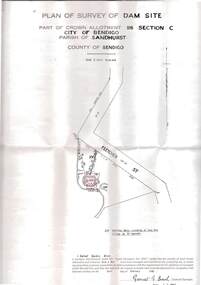
Plan - MCCOLL, RANKIN AND STANISTREET COLLECTION: PLAN OF SURVEY OF DAM SITE, 1941
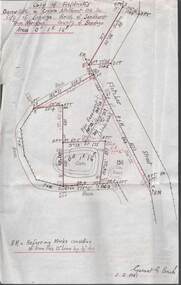
McColl Rankin & Stanistreet, Plan of Survey of Dam site, Part of Crown Allotment 98 Section C, City of Bendigo, Parish of Sandhurst, County of Bendigo. Signed by Garnet G Birch 1 Feb 1941. 33.5 x 43. Attached is a Copy of Field notes, Dam Site in Crown Allotment 198 Sec. City of Bendigo, Parish of Sandhurst. True Meridian, County of Bendigo, Area 0A 1R 16P. Signed Garnet G Birch, 1/2/1941. Drawn in red and black pen. 20.8 x 33. Both maps are for Deborah Extended Gold Mining Co. No Liabilityorganization, mining, deborah extended gold mining co nl, mccoll rankin & stanistreet, plan of survey of dam site -
 Bendigo Historical Society Inc.
Document - MCCOLL, RANKIN AND STANISTREET COLLECTION: DEBORAH EXTENDED GOLD MINING CO. NL, 1940
McColl Rankin & Stanistreet, Deborah Extended Gold Mining Co. No Liability, Lease. Inscription: Mortgagee under Mortgage N'bd... has consented to this Lease, See consent endorsed heron (signed) F O Hewison Assistant Registrar, Registrar of Titles 14 May 1941. Leases Copy. Other signatures: Donald McKinnon, Jean Woods, Jamie Jepson, Angus Mackay, J Stanistreet, A Gilcrist, ? Healy. Common Seal for: The Bank of Australasia and Deborah Ext Gold Mining Co NL. 2 maps of mine location.organization, mining, deborah extended gold mining co nl, mccoll rankin & stanistreet, deborah extended gold mining co nl lease -
Bendigo Historical Society Inc.
Map - CITY OF BENDIGO SHEET 2, No date visible
... Inc. History House 11 Mackenzie Street Bendigo goldfields MAP ...Map: City of Bendigo Sheet 2, Town plan ( number 143 in Map Cupboard 1)map, city of bendigo sheet 2, city streets -
Bendigo Historical Society Inc.
Map - BENDIGO SHEET 12, Reproduced 1961
... Inc. History House 11 Mackenzie Street Bendigo goldfields MAP ...Map; Bendigo Sheet 12, Parish of Sandhurst , County of Bendigo, Parish plan, Scale 2 chains to 1 inch ( number 142 in Map Cupboard 1)map, bendigo, city streets, bendigo sheet 12, parish of sandhurst , county of bendigo -
Bendigo Historical Society Inc.
Map - INFANCY OF BENDIGO, Original dated 28/10/1890
... Inc. History House 11 Mackenzie Street Bendigo goldfields MAP ...Map: Photocopy of the First sketch map of the Bendigo Diggings. Has been assembled from several photocopies taped together. Laid before the Frencham Committee by William Sandbach , a witness, 18 September 1890. There are Two of these maps. ( x ref 5673 , 8235 , Box 83 , 9077 )map, bendigo, city streets, infancy of bendigo, gold diggings, henry frencham, william sandbach, where was gold first found -
Bendigo Historical Society Inc.
Map - PLAN OF THE TOWNSHIP OF SANDHURST(PHOTOCOPY)
... Inc. History House 11 Mackenzie Street Bendigo goldfields MAP ...Map: Photocopy of a plan of the Township of Sandhurst. Dated 26 July 1854 ( number 141 in Map Cupboard 1)map, bendigo, city streets, township of sandhurst, early bendigo, city streets -
Bendigo Historical Society Inc.
Map - JANIEMBER WEST, 18/02/1913
... Inc. History House 11 Mackenzie Street Bendigo goldfields MAP ...Map: Parish of Janiember West, County of Bendigo ( number 140 in Map Cupboard 1)map, bendigo, rural, janiember west , county of bendigo -
Bendigo Historical Society Inc.
Map - NERRING, 15/06/1937
... Inc. History House 11 Mackenzie Street Bendigo goldfields MAP ...Map: Parish of Nerring, County of Bendigo. Parish plan Canvas backed ( number 139 in Map Cupboard 1)map, bendigo, rural, nerring, county of bendigo -
Bendigo Historical Society Inc.
Map - HUNTLY, 9th June 1880
... Inc. History House 11 Mackenzie Street Bendigo goldfields MAP ...Map:Huntly, County of Bendigo. Parish plan Canvas backed. ( number 138 in Map Cupboard 1)map, bendigo, city streets, huntly, county of bendigo -
Bendigo Historical Society Inc.
Map - BENDIGO (PART), No date visible
... Inc. History House 11 Mackenzie Street Bendigo goldfields MAP ...Map: Portion of Bendigo parish plan, showing from Murphy St. East to Bob St and between rail line to old saleyards to the old Heathcote line Canvas backed.map, bendigo, city streets, bendig parish plan , bendigo city streets -
Bendigo Historical Society Inc.
Map - BENDIGO SHEET 2, No date visible
... Inc. History House 11 Mackenzie Street Bendigo goldfields MAP ...Map: Parish plan showing portion of Bendigo city, West from the Echuca rail line, showing lake weeroona ( number 136 in Map Cupboard 1)map, bendigo, city streets, bendigo sheet 2, bendigo streets -
Bendigo Historical Society Inc.
Map - PORTION OF ELMORE ESTATE, 19/10/1920
... Inc. History House 11 Mackenzie Street Bendigo goldfields MAP ...Map: Portion of Elmore Estate, Parish of Egerton, County of Bendigo. Parish plan Canvas backed ( number 135 in Map Cupboard 1)map, bendigo, rural, elmore estate, egerton, county of bendigo -
Bendigo Historical Society Inc.
Map - PORTION OF ELMORE ESTATE, 19/10/1920
... Inc. History House 11 Mackenzie Street Bendigo goldfields MAP ...Map: Portion of Elmore Estate, Parishes of Warragamba and Diggorra, County of Bendigo. Parish plan Canvas backed ( number 143 in Map Cupboard 1)map, bendigo, rural, elmore estate , warragamba, diggorra , county of bendigo. -
Bendigo Historical Society Inc.
Map - SUBDIVISION OF STERNBERG'S ESTATE, 24/06/1920
... Inc. History House 11 Mackenzie Street Bendigo goldfields MAP ...Map: Subdivision of Sternberg's Estate, Crown Allotments 75, 76, 76A, 76B and 77, Parish of Rochester West, County of Bendigo. Parish plan Canvas backed ( number 133 in Map Cupboard 1)map, bendigo, rural, sternberg's, crown allotments 75, 76, 76a, 76b, 77, rochester west, county of bendigo -
Bendigo Historical Society Inc.
Map - MAHER'S AND PRETTY'S ESTATE, 8/02/1926
... Inc. History House 11 Mackenzie Street Bendigo goldfields MAP ...Map: Maher's and Pretty's Estate, Parish of Toolamba West, County of Rodney. Parish plan Canvas backed. ( number 131 in Map Cupboard 1)map, rodney, rural, maher's , pretty's, toolamba west, county of rodney -
Bendigo Historical Society Inc.
Map - PORTION OF ELMORE ESTATE, 19/10/1920
... Inc. History House 11 Mackenzie Street Bendigo goldfields MAP ...Map: Portion of Elmore Estate, Parish of Minto, County of Bendigo. Parish plan Canvas backed ( number 131 in Map Cupboard 1)map, bendigo, rural, elmore estate, minto, county of bendigo -
Bendigo Historical Society Inc.
Map - BAMAWM ESTATE, 12/.08/1912
... Inc. History House 11 Mackenzie Street Bendigo goldfields MAP ...Map: Bamawm Estate, Acquired under Closer settlements Acts 1904, County of Bendigo. Parish Plan Canvas backed. ( number 130 in Map Cupboard 1)map, bendigo, rural, bamawm estate, closer settlement acts 1904, county of bendigo