Showing 30541 items
matching hill
-
 Eltham District Historical Society Inc
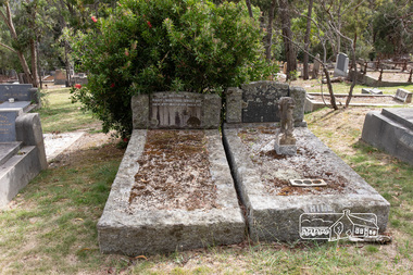
Photograph, Peter Pidgeon, Graves of Mary Josephine Swallow, John Swallow (unmarked) and Patricia Catherine Hill, Eltham Cemetery, Victoria, 5 April 2021
On the 29th of May 1954, a local Eltham carpenter by the name of John Swallow, committed a double murder at his home on New Street. This happened on the same day as the federal election of that year. John 48, his wife Mary 47, and stepdaughter Patricia 25, all went to the Eltham Courthouse on Main Road to cast their vote in the election that Saturday. After voting they returned home to their New Street house around midday. Patricia would later recall to ambulance officers, that she was feeling unwell, and so went to lay down when she heard an argument erupt over voting between her mother Mary and stepfather John. A concerned neighbour heard loud thudding noises and yelling coming from John and Mary’s house, he went to investigate. When he arrived at the house he was met by John at the front door. He would later describe John as “having a frantic look upon his face, and manic eyes”. John must have been a sight, bleeding and clutching a cut throat razor by his side. He then announced to the neighbour, “they voted commie!” before turning and going back inside. The distressed neighbour immediately raced home to call the Police. When the police arrived, they found Mary dead on the kitchen floor from catastrophic head injuries; her daughter, Patricia, clinging to life, slumped on her bed. Both women had been attacked by the same weapon, a large hammer, or sledge hammer as reported by the newspapers. John was also discovered in the house, bleeding from self-inflicted wounds from the razor, and had attempted to ingest caustic soda. Patricia was taken to St Vincent’s hospital, but died the following day, the 30th of May. John was also taken to St Vincent’s, where he remained under constant police guard for several months while he recovered from his injuries, at least the physical. He was eventually well enough to be taken to the City Watch House and then Pentridge Prison before his trial in October of the same year. When it came time for John to face the courts, the Judge called a mistrial, the Crown would not prosecute on the grounds of insanity. John was led away from the dock of The Magistrates Court and taken directly to Willsmere, the Kew Mental Asylum. On the 9th of August 1962, John Mervyn Swallow died of heart failure, he was 57. He had been a resident of Kew for four years. John’s body was returned to Eltham Cemetery and buried in the same grave as Mary. There is no mention of his name on the head stone. Patricia’s grave is next to Mary and John. A sad irony has an angel upon her grave, “its head missing”, possibly vandals or just an accident of time and events. What became of the home where all of this took place on New Street shall remain a mystery but within six months of this horrific event, the street had been re-named to Lavender Park Road after the original property near the end of the road, Lavender Park. In Memory Of Mary Josephine Swallow Died 29th May 1954 aged 47 Also Patricia Cathryn Hill Dearly beloved wife of Kel Called home 30th May 1954 Aged 25 yearsBorn Digitaleltham cemetery, gravestones, mary josephine swallow, patricia catherine hill, john swallow -
 Uniting Church Archives - Synod of Victoria
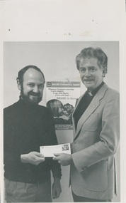
Photograph, 1987
Reverend John Hill was ordained in 1969 who served at Myrtleford, Wattle Park, Mitchell Presbytery, Stawell, Commission for Mission, United States, and Bendigo West Reverend Robert Mackay Cross served in Shepparton North, Chaplain of Queen Elizabeth Geriatic Centre Ballarat, Chairman and Executive Secretary of the Division of Community Services.B & W photograph showing Reverend Cross presenting a cheque to Reverend John Hill, minister at Stawell and chairman on state recovery committee for disaster relief."Rev John Hill (right) Rev Robert Cross (left) C&N 22/7/1987 page 29"hill, john, cross, robert -
 Whitehorse Historical Society Inc.
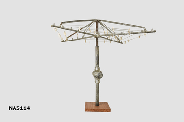
Leisure object - Miniature rotary clothesline
Used as a child's toy. possibly produced as sample for Hills Hoists Company.Example of Australian domestic design c 1940's / 1950's.Miniature rotary clotheslineHills Hoistshills hoist - australian domestic design. -
 Kew Historical Society Inc
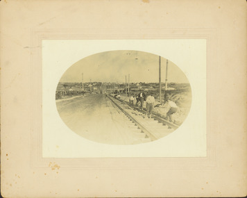
Photograph - Construction of the electric tram line in Riversdale Road, Surrey Hills, E.J. Dower, 1916
One of a series of photographs, taken by Edgar James Dower in the second decade of the twentieth century. Born and raised in Olinda, his family later moved to Surrey Hills. He worked as an adult as a clerk in the city office of the Metropolitan Gas Company, and in his role as a 'collector', he was able to photograph scenes including the construction of tramlines and associated buildings in Kew, Hawthorn, Camberwell and Surrey Hills. Later he established a real estate agency with his brother - the E.J. Dower Real Estate Agency, Dandenong Office.The image is an historically significant record of the development of transport infrastructure which was used to connect Victorians in the first two decades of the twentieth century. This development resulted from increases in population and the consequent extension of Melbourne's suburbs. The photographs, both individually and collectively, richly detail the labour of workers and the tools and machinery used to create and extend Melbourne's tram network in the years preceding and during World War 1.Digital copy of an original oval mounted photograph of the construction of the tracks for the new electric tramline in Riversdale Road, Surrey Hills. Annotated verso: "Preparing for electric tram line, Riversdale Road, Surrey Hills / Taken from near Warrigul [sic] Road / note Essex Road on right with picket fencing."theme --- travelling by tram, theme -- connecting victorians by transport and communications, trams -- boroondara (vic.), riversdale road -- surrey hills -
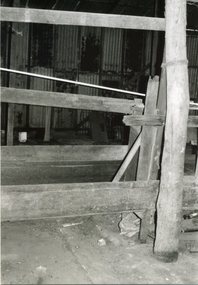 Ringwood and District Historical Society
Photograph-B&W, Hill's Dairy, Canterbury Road, Ringwood 1989-Barn interior, 6/07/1989
Hill's Dairy, Canterbury Road, Ringwood 1989-Barn Interior "where the cows' bails had been"Hill's Dairy / where the cows' bails had been -
 Clunes Museum
Photograph
Photocopy of a colour photograph of tony Hill, Clunes Football Club Best and Fairest 1975Printed on bottom of photograph Tony Hill Best and Fairest 1975clunes football club, tony hill, 1975 -
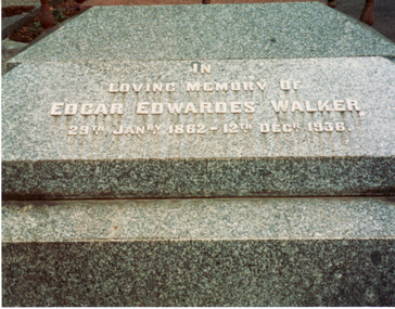 Whitehorse Historical Society Inc.
Photograph, E.E. Walker Tombstone
Coloured photo of E.E. Walker Tombstone in Box Hill Cemetery.walker, edgar edwardes, box hill cemetery -
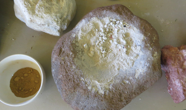 Ballarat Heritage Services
Photograph - Colour, Clare Gervasoni, Grindstone and Ochre, 25/12/2015
Photograph of a Grindstone and Ochre on display at the Tower Hill Interpretation Centre.tower hill, grindstone, ochre, aboriginal, aborigines -
Glenelg Shire Council Cultural Collection
Photograph - Photograph - Robin Hill and wife, n.d
Port of Portland Authority ArchivesBack: Mrs & Robin Hill - blue biroport of portland archives, picnic, robin hill -
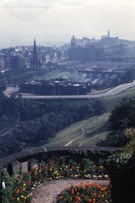 Robin Boyd Foundation
Slide, Robin Boyd, 1950
Penleigh Boyd, Robin and Patricia Boyd's son, writes “Prior to 1950 Robin, like most other amateur or hobby photographers, took black and white printed photographs. The oldest slides date from 1950 when Robin and Patricia travelled to Europe on Robin’s Robert Haddon Travelling Scholarship.” In 1948 Robin Boyd was awarded ‘joint first place’ in the Robert Haddon competition for his design of Mildura art gallery. The scholarship helped fund their first overseas trip. Robin and Patricia were passengers on the Greek ship “Cyrenia” departing in May 1950, passing through the Suez Canal and landing in Genoa five weeks later. For six months, they travelled extensively throughout Europe (predominantly driving themselves) - France, Italy, United Kingdom, Sweden, Denmark, Germany, Austria, Switzerland and Spain.Colour slide in a mount. Edinburgh, with Calton Hill in background, ScotlandScotland / Edinburgh / From Castle: W.Scott MEM- To Carlton Hill (All Handwritten)haddon travelling scholarship, haddon, robin boyd, slide -
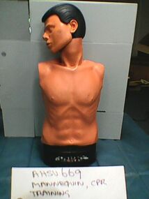 Ambulance Victoria Museum
Mannequin, CPR training, Ambu, Circa 1985
Used by Rural Ambulance Victoria for cardio pulmonary resuscitation (CPR) training. The inscription Swan Hill T.A.E. indicates that object was used at Swan Hill by either Rural Ambulance Victoria or perhaps by another owner at some point.Head and torso mannequin with grey plastic travel case. Mannequin has electronic reader at base.SWAN Hill T.A.E. rural ambulance victoria -
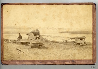 Flagstaff Hill Maritime Museum and Village
Photograph - Historical, maritime, 1878
The location of this photograph is disputed by historians, but the consensus is that is shows the early use of Flagstaff Hill by the Warrnambool Garrison. This photograph is very similar to one on file in the State Library of Victoria (SLV). The photograph in the State Library's collection is clearer, and is in black and white. It also has an inscription below it "Lady Bay, Warrnambool, 1878'. The inscription on the lower left of the SLV's photograph looks to be the same as on Flagstaff Hill's copy. The photographer is unidentified. The photograph is significant to Warrnambool's local history. It is connected to the 1870's defence of the Port of Warrnambool, and to southwest Victoria's coast. The photograph can be used as a comparative tool for measuring the changes in the landscape and the harbour.Photograph, sepia, on card. Unknown photographer. View towards Lady Bay, Warrnambool. A gentleman is seated on one of two cannon carriages with cannon, on a hill above a picket fence. A moored sailing ship is in the bay. Hills are in the background and la building is on land to the right. The photograph is mounted on card with a brown, hand coloured border on the front. The corners on the card are rounded. the reverse has round marks in the corners indicating that the photograph has been previously mounted, perhaps in an album. There is a purple stamp and some pencil inscriptions. A handwritten pen inscription is on the lower left corner of the front. [(1b) This black and white photograph is a copy of the original and has been printed on larger paper.]Front: "[undecipherable] / photo" Reverse in pencil: " REG. NO. 2172.1 / ORIGINAL" Reverse, stamped: "Flagstaff Hill Maritime Village"flagstaff hill, warrnambool, shipwrecked-coast, flagstaff-hill, flagstaff-hill-maritime-museum, maritime-museum, shipwreck-coast, flagstaff-hill-maritime-village, photograph, warrnambool, lady bay, lake pertobe, cannon hill, middle island, steam ship, breakwater, cannon, victoria, man seated on cannon, 1878, militia fort, port of warrnambool, militia, garrison, warrnambool garrison -
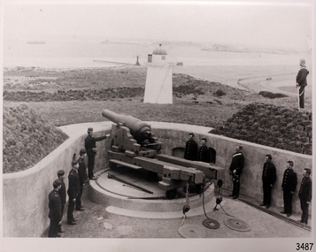 Flagstaff Hill Maritime Museum and Village
Photograph - Military, Volunteer Corp, mid-1800s
This photograph relates to the early group of the Volunteer Corps preparing to defend their country.The photograph is a significant record. It shows a point in time when local volunteers were prepared to defend the south west coast of Victoria.Black and white photograph of Volunteer Corp firing the gun on Flagstaff Hill. flagstaff hill, warrnambool, flagstaff-hill-maritime-museum, photograph, volunteer corp, gun on flagstaff hill, fortifications volunteer corps., fortifications, volunteer corps, maritime museum, maritime village, great ocean road, shipwreck coast, militia, barracks -
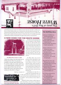 Whitehorse Historical Society Inc.
Pamphlet, The story of Box Hill's White Horse - the symbol of a city, 1/09/1993 12:00:00 AM
History of Box Hill's White Horse. 6 double sided, illustratedwhite horse hotel, city of box hill, local government -
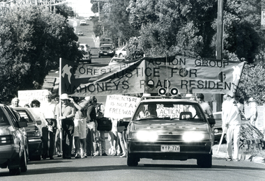 Whitehorse Historical Society Inc.
Photograph, Protest March, 4/03/1989 12:00:00 AM
Black and white photo of Protest March in Mahoneys Road, Forest Hill.to be entered -
 Ballarat Heritage Services
Photograph - Colour, Clare Gervasoni, Headstone of J.H. Fitzgerald, 2019, 03/01/2019
Herbert (Bert) Hulm was gassed during World War One. He served with the 46 Battalion. His niece remembered he was always laboured in his breathing.Colour photograph of the memorial plaque for J.H. Fitzgerald in the Tower Hill Cemetery.VX40138 Signalman J.H. Fitzgerald Corps of Signals 18th December 1966 Age 50 Loved husband of Thelma and devoted father of Barry.tower hill cemetery, world war two, j.h. fitzgerald, thelma fitzgerald, barry fitzgerald -
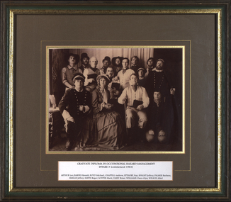 Federation University Historical Collection
Photograph - Photograph - Black and White, VIOSH: Graduate Diploma in Occupational Hazard Management - Intake 3, 1981, 1981
Victorian Institute of Occupational Safety and Health (VIOSH) Australia is the Asia-Pacific centre for teaching and research in occupational health and safety (OHS) and is known as one of Australia's leaders on the field. VIOSH has a global reputation for its innovative approach within the field of OHS management. VIOSH had its first intake of students in 1979. At that time the Institution was known as the Ballarat College of Advanced Education. In 1990 it became known as Ballarat University College, then in 1994 as University of Ballarat. It was 2014 that it became Federation University. VIOSH Australia students are safety managers, senior advisors and experienced OHS professionals. They come from all over Australia and industry. Students are taught active research and enquiry; rather than textbook learning and a one-size fits all approach. VIOSH accepts people into the Graduate Diploma of Occupational Hazard Management who have no undergraduate degree - on the basis of extensive work experience and knowledge. Students would have attended Ballarat College of Advanced Education. Names to correspond with photograph 19975 1. Roger Smith 2. Ronald Barnes 3. Max Brooke (Instructor) 4. Raymond Epthorpe 5. Geoff Chappel 6. Athol Wilson 7. Mike Boyd 8. Geoff Knight 9. Brian Vasey 10. Glen Williams 11. Mark Sonter 12. Vic (?) 13. Barbara Palmer 14. Leo Arthur 15. Jeffrey Smillie A timber framed black and white photograph taken at Sovereign Hill of a group of thirteen people dressed in period costume with a name plate at the bottom. Sepia photograph mounted on cardboard. Photographer's information.Typed name plate with names Card printed with - Red Hill Photographic Rooms, Sovereign Hill, Victoria.viosh, viosh australia, graduate diploma in occupational hazard management, leo arthur, ronald barnes, michael boyd, andrew chappell, ray epthorp, jeffrey knight, barbara palmer, jeffrey smillie, roger smith, mark sonter, brian vasey, owen glyn williams, athol wilson -
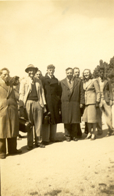 Federation University Historical Collection
Photograph - Photograph - Black and White, Ballarat Teachers' College Picnic, 1947, 1947
The Ballarat Teachers' College had a number of excursions and events including the college picnic.Two black and white photographs of Ballarat Teachers' College students at a picnic. .1) nine adults pose for a photograph. All are standing. .2) Three males 'play rough' on an oval..1) - verso "College Picnic" .2) - verso "Sammy Boyd, David Cooper (Charles), Tom Hill. College picnicballarat teachers' college, boyd, cooper, hill, picnic, student activity -
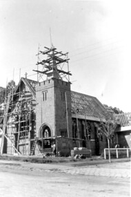 Surrey Hills Historical Society Collection
Photograph, Holy Trinity Church under construction: exterior view, 1921, 1921
Norman Carter took many photos of Surrey Hills and Mont Albert from the 1920s; many were associated with events and activities of the Church of England.Black and white photo taken from diagonally opposite Holy Trinity Anglican Church, Surrey Hills in Union Road, showing the brick skin of the building and the timber frame of the roof. There is scaffolding on the front face and around the spire.On back of original in pencil: "9th Oct 1921" and in a different hand in biro: "Holy Trinity Church / Surrey Hills / Progress of building / 9.10.1921"holy trinity, churches, anglican churches, construction and demolition, norman carter -
Coal Creek Community Park & Museum
Tin, herbs, Wilkinsons & Co. Ltd
Cylindrical shaped tin with push on lid, label around sides depicting person on camel with text in dark blue, white, light blue, red, gold, yellow, green and black.ARAB Herbs. Packed by the Proprietors Wilkinsons & Co. Ltd, Adelaide & Broken Hill. Mixed Sweet Herbs. -
Port Melbourne Historical & Preservation Society
Newspaper - Newspaper (facsimile), Emerald Hill Weekly News and South Melbourne Advertiser, 20 Apr 1857
Facsimile of issue of Emerald Hill Weekly News and South Melbourne Advertiser 1857newspapers, publishing, emerald hill weekly news & south melbourne advertiser -
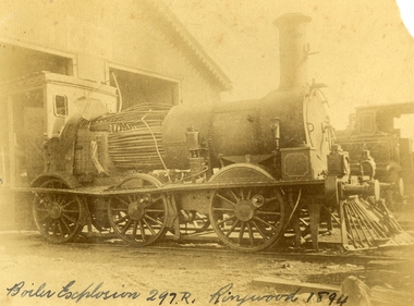 Ringwood and District Historical Society
Photograph, Boiler explosion at Ringwood station 20th June 1894 for engine 297R. "Heard in Box Hill"
Black and white photographs - 2 copiesTyped below photograph, "Boiler explosion at Ringwood station 20/6/1894. Heard in Box Hill". Article from newspapers:- Weekly Times (Melbourne, Vic. : 1869 - 1954), Saturday 27 January 1894, page 21 Official enquiry. The Board of Enquiry appointed by the Railway Commissioners to enquire into the causes of the boiler explosion which shattered the locomotive at Ringwood on Saturday night, assembled at the Railway department on Wednesday to commence its deliberations, The board consisted of Mr R. Fulton, engineer, C. W. McLean; engineer to the Marine Board, and Mr Mephan Ferguson, iron-founder. There is some difficulty at the outset about the constitution of the board; It was suggested that the Apt of Parliament contemplated that boards of experts, after the manner of the present one, needed, to have their appointments confirmed by the Governor-in-Council. The point, however, was not considered sufficiently important to prevent the board from proceeding with evidence. Robert Greyford, stationmaster at Ringwood, was the first witness. He said he saw the explosion on Saturday night at about twenty minutes to 8. There was a rush to the engine to see what had happened, and the driver and fireman were both found on the platform of the engine. The driver seemed badly hurt, but the fireman, to all appearances, was not so badly injured. They were both attended to and sent up to Melbourne by the last suburban train. Witness had a look at the engine and found the dome and all the plates round the boiler blown clean, away. The springs were also blown clean away. The Chairman (Mr Fulton) : Did you measure the distance ? Witness: Yes; one of the plates was 209 yards away. A piece from the top of the boiler 15 pounds in weight he found driven into the hard beaten track 410 yards away. Several pieces of boiler plate were found scattered at various distances. The buildings roundabout were injured. The Chairman; Did you notice anything peculiar about either of the driver or the fireman ? — No ; nothing wrong, with either of them. If the engine was blowing off at all, it must have been very light. In your opinion, were they perfectly sober ? — Perfectly. In approaching the station, is there a down or an up grade? — A very slight down grade. How is the road from Healesville ? — Up and down all the way. It is down, grade for about 200 yards coming into Ringwood station. They shut off ; steam about a quarter of a mile away, and come in at a good pace. They generally put on 15 pounds of steam while they are in the station. Mr Ferguson : Had the driver the usual load on ? — Yes ; about the usual load. Witness added that he had known the driver personally for about 10 years, and he had always been a careful, steady, sober man. He did not know the fireman so well. John Palmer, porter at Ringwood station, also saw the explosion. He was attending to the train on its arrival. He was knocked down by the force of the explosion. When he got up he saw the engine driver being carried into the office covered in blood. He noticed nothing peculiar about the driver and fireman, nor about the engine. Mr McLean : How far were you from the engine when you were knocked down ? — From ten to fifteen yards. William Paul, the guard of the train to which the injured locomotive Was attached, said he was looking at the engine at the very moment the explosion occurred. It seemed to come from exactly under the dome. The force of it took him off his feet. He was about 15 yards from the tender. When he rose he tried to reach the engine, but could not do so on account of the steam and coal dust. He called out to know whether any of the passengers were injured, and got no response, so that he concluded they were all right. All the lamps but about half dozen were extinguished by the force of the explosion, although the glass was not broken. He could testify most distinctly that the driver and fireman were both sober. The driver was a man who never drank. The steam started to blow off about a minute and a half before the explosion took place. The last place at which the engine took water was Healesville. The Chairman : Do yon know anything of the quality of the water there ? Is it creek water ? — Yes ; it comes from the Graceburn River. You never heard of its quality ?— No. How long have you known this engine on the road— About 13 months. Hew long have you known the driver on this line ? — About six weeks. I have known the fireman several years. The driver was a strict teetotaller, and I never saw the fireman take anything to drink in his life. Mr T. H, Woodroffe, chief mechanical engineer of the Victorian Railways, produced a report he had written to the secretary, about this explosion. The document gave facts concerning the engine and the explosion. It stated that the rapture seemed to have occurred at the rim of the plates adjoining the fire box. The engine was built at the Phoenix Foundry, Ballarat, in 1883. It was repaired at various times, the last time being in July of last year when it was sent to the Port Melbourne shops, and was then tested to a cold water pressure of 195 and found all right. It was the custom to overhaul all locomotives about every five years. The Chairman : There were no very heavy repairs in July, 1893; were there? — Not to the boilers. The shop manager's report says that the plug and safety tap holes were repaired, five new copper studs put in firebox, ash-pan door repaired, tender cleaned and overhauled, and studs re-rivetted, and boiler tested to pressure of 195, cold water. Mr Woodroffe read the report of the repairs effected to the boiler in December, 1888. That would be the time the plate was put in the boiler. On that occasion three new plates were put in the bottom and the boiler tested up to 195. The Chairman: Do you keep a record of the water used ?— Yes, the water in this case, I think, came from the Maroondah scheme. Mr Woodroffe said boilers were examined front time to time in the running sheds. In his opinion every possible care had been taken to keep the engine in proper care. There might, however, be lessons learnt from this. The Chairman: No doubt. From his examination of the plates [the] witness did not think the state of them could have been detected from the outside. There were no signs of leakage or sweating or anything of that sort. The next witness- was Walter Stinton, workshop manager at Newport and he said that the injured engine had been repeatedly repaired under his charge. He gave a technical account of the repairs effected on various occasions. The testing of locomotives was under his special notice. They had a high pressure pipe running; round the works, and a pump set at 2001b. When the boiler was pumped full of water the pressure when applied up to 1951b. The board appointed by the department to inquire into the Ringwood locomotive boiler explosion sat again at Spencer street on 25th inst. Mr R. Fulton presided and the other members of the board were. Mr Mephan Ferguson and Mr C. W. McLean. Charles Grubb, foreman of the boiler-makers at the Newport workshops, said he had inspected the pieces of plate that had been blown out of the engine, and after examining them, pointed out to the Chief Mechanical Engineer the portion where the plate had started to burst. It was under the lap, on the right hand side of the boiler. The grooving might be accounted for by bad water. During the past twenty years he had examined all the boilers that came into the Williamstown workshops, and while some were hardly marked at all, others were very badly eaten away. The practice was to cut out the defective portions. In this case the boiler was repaired in a similar manner. The Chairman : Can you suggest any other way of repairing so as to prevent accident ? — No, unless by taking out a plate on one side from the joint, and carrying it further up so as to avoid the joints meeting, or by taking out the plate altogether. What would.be the cost .of putting in a new " plate I—Perhaps about double the price; but I wouldn't recommend that course. It would be putting a new plate against plates that have been in use ten years or so and that would not be advisable. I think the present system better. I consider the present system of repairing the best. This is the first we have had so bad like that, to my knowledge. You attributed this to bad water. Is there no other probable cause ? — Well; unless the iron be bad. This was Lowmoor iron. I think this accident was caused by the eating away of plates. This one was the worst I have seen, for the short time it had been running. We use three classes of iron — Lowmoor, Monkbridge and Bowling. By Mr Woodroffe (Chief Mechanical Engineer) ; There are engines still running that were repaired at the same time as this one, in 1888, and. in the same way. These are engines 339 and 333. They have been recently examined and are in splendid order. What in your experience, is the age of a boiler on the Victorian railways? — From 17 to 20 years our earlier boilers stood. The later boilers don't stand so well. How is that? — There is difference in construction, and the material is lighter. The old boilers had thicker plates. Have you been asked in any way to curtail boiler affairs? — No, sir; nor in any way. You have never hesitated to carry out any necessary repairs? — Never. Our orders have been to exercise every care in examining, repairing and renewing boilers. Witness said that his practice was when an engine came into the workshop to find out how long she had been running. If over five years, he informed the workshop manager, and they thought it necessary the tubes were taken nut. If everything was in good order witness reported to the manager. The cost of taking out the tubes and putting them in again was about L20. Mr Woodroffe : Have you ever hesitated to repair a boiler on the score of expense ? — No, never. Mr McLean : Hew do yon ascertain whether a boiler requires repairs?— I keep a record of every boiler examined. From every boiler that comes in I have the dome covers taken off, and when it is practical I get inside. l can almost tell from the top of a boiler what the bottom is like. If there is any doubt about it I have the tubes taken out. If I have suspicion of defective plate I cause to have bored a triangle in the plate at the point where there is the most wear. There is a travelling inspector who visits all the running sheds of the colony except Port Melbourne and tests the boilers. He reports to us and we note what he points out. Alfred Thompson, locomotive inspector of the eastern section, said he knew this engine, 297R. He read a list of her repairs. He heard of the accident on Saturday night and went up to Ringwood. The Chairman : Did you ever notice anything peculiar about the engine? — No, I considered her A1 and would not have hesitated to have put on 140lb pressure owing to the repairs she had undergone. Witness considered that the explosion was caused by the expansion and contraction of the plates ; and, no doubt, the plate had been eaten away through bad water. The other side of the boiler showed: signs of corrosion: By Mr Woodroffe ; Is every care taken with the boilers ? — Yes, every possible care is taken for the safety of boilers, Weekly Times (Melbourne, Vic. : 1869 - 1954), Saturday 27 January 1894, page 7 EXPLOSION OF A LOCOMOTIVE BOILER, NARROW ESACPE FROM FATALITIES. THE DAMAGED ENGINE. [See drawing of loco – saved in “Railways” folder] The explosion of a locomotive boiler at Ringwood on Saturday evening, formed the subject of much discussion in railway circles on Monday. The Minister arrived at the office at an unusually early hour and immediately entered into a consultation with the acting chairman, Mr Kibble, and Mr Commissioner Murray. As the result of the interview it was resolved to ask three gentlemen of acknowledged engineering experience to sib as a board with the . object of inquiring into the cause of the accident and furnishing a report. Mr Richardson and the Commissioners are tally seized of the importance of having a searching investigation into the accident, and, with Mr Murray, the former went to Ringwood to inspect the scene of the disaster. They will he accompanied by Mr Woodroffe. During the morning no official report had come to hand from the driver or fireman of the engine in reference to the accident, but that is thought to be due to the circumstance that they have not sufficiently recovered to be able to give a circumstantial account of what occurred. The engine was one of the old R's, and, Mr Kibble pronounced them to be about the best class of engines used. So far nothing can be said as to the probable cause of the accident, as the broken plating of the engine has not been submitted to the inspection of experts. Weekly Times (Melbourne, Vic. : 1869 - 1954), Saturday 27 January 1894, page 7 STATEMENT BY THE FIREMAN. This morning Thomas Miles, fireman on the engine the boiler of which exploded on Saturday night, is suffering from an injury to the spine, as well as a very severe shaking to the system. He states that he was fireman on the engine attached to the train which left Healesville on Saturday evening, at ten minutes to 8. Everything went all right until Ringwood was reached, when, .just as the train was about to continue its journey, a load explosion took place and Miles remembers nothing more until he was picked np on the platform ; and found himself suffering from a pain in the back, and an injury to his arm. He cannot think of any reason which could have caused the explosion, as there was plenty of water in the boiler, and everything seemed working all right. Mr R. Fulton, consulting engineer, of Queen street; Mr McLean, a member of the Marine Board ; and Mr Mephan Ferguson, engineer, have consented to act as a board to inquire into the cause of the engine boiler explosion at Ringwood on Saturday evening. The board has been appointed under section 117 of Act 1135, which provides that the Governor-in-Council may direct the taking of a such a step. Mr1 Fulton will act as chairman of the board, which met for the first time at the railway offices, Spencer street, this forenoon. Before separating the members of the Board paid a visit to the Prince's Bridge locomotive sheds in company with Mr Woodroffe, the chief mechanical engineer, for the purpose of inspecting the shattered boiler. It has been stated that the explosion is known to have been caused by a flaw in a plate which was put on the boiler about four years ago, but enquiries have tailed to elicit anything in support of that view. The engineers connected with the department are not inclined to say anything on the subject. Weekly Times (Melbourne, Vic. : 1869 - 1954), Saturday 14 April 1894, page 20 The Ringwood Boiler Explosion, The Minister of Railways has received the supplementary report of the board appointed by him to investigate the circumstances connected with the explosion of a locomotive boiler at Ringwood. In their first report the board did not attach blame to anyone. Mr Richardson felt satisfied that the responsibility of having the engines properly inspected and overhauled periodically could be fixed if the inquiry were extended. He therefore referred the matter again to the Board, who took further evidence. In the report now furnished, the Board hold Loco. Inspector Thompson blameable, but point out as a mitigating circumstance that he had not received "written instructions" respecting inspections and overhauls. Weekly Times (Melbourne, Vic. : 1869 - 1954), Saturday 7 July 1894, page 32 The Ringwood Boiler Explosion. The Minister of Railways takes exception to the tone of a paragraph appearing in a morning contemporary respecting the Ringwood boiler explosion. It makes it appear that Mr Richardson has referred the report of the board which considered the facts connected with the explosion to the Crown solicitor simply because he differed from the finding of the board. The Minister explains that when he received the report he found that the responsibility for having boilers properly inspected and overhauled had not been clearly fixed. He personally obtained farther evidence on that point, and arrived at a conclusion, from which the commissioners differed. As he did not like to take upon himself the responsibility of deciding upon the effect of the evidence, he submitted the matter to the Crown Solicitor, but that officer did not furnish him with the information sought. He has, therefore, referred the question to the Attorney-General, together with the draft of a regulation respecting boiler inspections and overhauls in the future. Mr Richardson says that his whole aim is to have the responsibility positively fixed. Weekly Times (Melbourne, Vic. : 1869 - 1954), Saturday 28 April 1894, page 23 The Minister of Railways has completed his consideration of the supplementary report received by him from the Ringwood Boiler Explosion Board. The report, it will be remembered, held Loco-Inspector Thompson blameable for the non-inspection of the boiler, but considered there was extenuating circumstances. There was a certain amount of doubt as to the absolute instructions given for overhauling engines periodically. Mr. Richardson is sending the report on to the Commissioners with instructions that the responsibility respecting inspection of boilers shall be made clear for the future. -
 Surrey Hills Historical Society Collection
Photograph, Surrey Hills Reservoir No 1
Copied by Ken Hall from an early postcard. This is Surrey Hills Reservoir No 1 on the corner of Tower Street built in c1892 at a cost of £12,000 to supply higher sections of the area. The builders were Jack and Bob Laudehr, partners in a wood yard in St. Kilda (Vic). They began by delivering firewood but extended to contract work involving timber. Another of their projects was to lay cable tram tracks commencing in Acland Street St. Kilda and running along The Esplanade. The reservoir in Canterbury Road was a large concrete structure built before the introduction of reinforcements. The excavated material was banked against the sides and pine trees were planted in it to add strength to the embankment. They were paid £2,000 for their work. Construction of Surrey Hills Number 2 Reservoir was completed in 1913 and the accompanying tower was built in 1929. It is assumed that the Miss Hill as the source of the donation (via Bill Dempsey) was Ivy Annie Hill (1902-1984). She was the only female child of William Valentine Dempsey to not marry. Bill Dempsey's mother was Laura Constance 'Birdie' Hill (1900-1968) who married Albert Dempsey.A sepia photograph within a post card of a reservoir on Canterbury Road, Surrey Hills. In the background to the left you can see the top halves of two houses and the tops of some trees. The photo takes up only the central section of the postcard.Below the photo on the front of the postcard on blue biro "Reservor [sic] Canterbury Rd / Surrey Hills." On the rear in grey lead pencil in Jocelyn Hall's handwriting: "Donor W Dempsey ------------- Keep / (nephew) / [arrow pointing down] / From Miss Hill / 10 Pembroke St SH / This house can be / seen in front of / No 12 which has / tower"1890, water supply, mmbw, edward d dyer (mr), 10 pembroke street, 12 pembroke street, surrey hills, ivy annie hill (miss), william valentine hill (mr), canterbury road, tower street, water supply structures and establishments, dams and reservoirs, jack laudehr (mr), bob laudehr (mr) -
 Ringwood and District Historical Society
Photograph, View from Loughnans Hill showing the antimony mine and brickworks towards East Ringwood c.1912
One postcard and same view duplicated in a larger photo. Houses across centre are in Warrandyte Road. -
 Ringwood and District Historical Society
Photograph, Maroondah Highway East, Ringwood- 1969. Looking north from Braeside Ave towards Loughnan's Hill
Black and white photographWritten on back of photograph: "From Civic Centre, Nov 1969. -
 Ringwood and District Historical Society
Photograph, Kubis Estate, North Ringwood in April 1978. Looking up the hill in Kubis Drive from the site of headwaters of Loughnan's Lake. Jenkins Close takes off to the right from centre
E548 N31 Part of a 51-photo record of the development of the "Kubis" Estate, Ringwood North, including road works to Debbie Place, Kubis Drive, Werac Drive, Manuelo Drive, Iluka Place and Glenvale Road. From the Jack Lundy Clarke collection. -
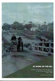 Phillip Island and District Historical Society Inc.
Book, At home on the hill - Stories of Pioneers in the first 30 years of Phillip Island cemetery 1870-1900 Written by Pamela Rothfield, 2018
Stories of the first 73 occupants of the Phillip Island Cemetery describing the lives and history of the early residents of Phillip Island. Written by a Cleeland descendant, Pamela Rothfield.HistoricalLarge, soft covered book with large black and white and coloured photos and text.ISNN 978-0-646-99552-6phillip island cemetery, genealogy, forrest, jenner, richardson, cleeland, dixon, mcgregor, reid, walton, west, cox, underdown, mcillwraith, woolcock -
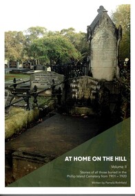 Phillip Island and District Historical Society Inc.
Book, At home on the hill. Vol. 11 : the story of those buried in the Phillip Island Cemetery between 1901-1920 : everyone has a story by Pamela Rothfield, 2020
Detailed information on people buried in cemetery from 1901-1920HistoricalLarge soft covered book with text numerous black & white and coloured illustrations ISBN 978-0-6487351-0-6phillip island cemetery, rev. alexander robb, richardson, walton, grayden, forrest, leeson, lock, mcfee, george smith, west, cleeland, eliza cochlan, findlay, jenner, mckindlay, jeury, walpole, george cox, pamela rothfield -
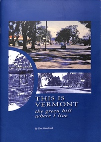 Ringwood and District Historical Society
Book, This is Vermont - The Green Hill White I Live, 2010
History of Vermont, Victoria - including interviews and photographs dating from European settlement circa 1830, compiled from research over four years to 1987 by Tim Shambrook.Author's note includes acknowledgement to Whitehorse Historical Society Inc. (previously Nunawading). First published 1987; first reprint 1989; second reprint 1994. This is a revised edition printed in 2010. -
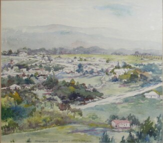 Ringwood and District Historical Society
Painting, Margaret Robbie, "View from Loughnan's Hill" (Ringwood) - Water colour on paper by Margaret Robbie, circa 1950s
"Margaret Robbie was another of the local painters who came late to art or combined it with a quite different occupation. Her grandparents, John Shaw and Margaret (Byers), went to Hobart in 1855 but then crossed the Strait and settled in Kyenton where they remained until 1918. Margaret was the issue of the marriage of Mary Shaw and Robbie. She spent a considerable time overseas for the YWCA, including a period as its General Secretary in Toronto, Canada, and worked in the Middle East during World War 2. Margaret Robbie made her garage in Ringwood Street into a flat-cum-studio-cum-gallery for her painting activities when she was not caring for her sister and an elderly aunt." - Hugh Anderson - Ringwood, Place of Many Eagles [p.218].Painting with cardboard border in glass-fronted frame.Inscription along lower edge of painting - "Margaret Robbie, copied from a postcard", and sticker on back of frame - "Ringwood Framing Gallery, 233 Whitehorse Road Ringwood, Phone 8704930"