Showing 110304 items matching "roads"
-
 Eltham District Historical Society Inc
Slide, Beard Street, Eltham, Nov. 1981
... roads ...Roll of film taken by Eltham Shire Council officers (Nov. 1981) of the Beard street group, a private street scheme, before construction commenced in February 1982. They provide perspective of the changes in housing styles and road development that began sweeping in from the mid 1970s with increasing urbanisation of what was once more outlying suburbs and regions.35 mm colour positive transparency (1 of 27) Mount - Kodak Ektachrome CardProcessed 18 Jan 1982beard street, eltham, housing estate, infrastructure, private street scheme, roads -
 Eltham District Historical Society Inc
Slide, Frank Street, Eltham, Nov. 1981
... Roads ...Roll of film taken by Eltham Shire Council officers (Nov. 1981) of the Beard street group, a private street scheme, before construction commenced in February 1982. They provide perspective of the changes in housing styles and road development that began sweeping in from the mid 1970s with increasing urbanisation of what was once more outlying suburbs and regions.35 mm colour positive transparency (1 of 27) Mount - Kodak Ektachrome CardProcessed 18 Jan 1982foster way, frank street, housing estate, infrastructure, private street scheme, roads -
 Eltham District Historical Society Inc
Slide, Frank Street, Eltham, Nov. 1981
... roads ...Roll of film taken by Eltham Shire Council officers (Nov. 1981) of the Beard street group, a private street scheme, before construction commenced in February 1982. They provide perspective of the changes in housing styles and road development that began sweeping in from the mid 1970s with increasing urbanisation of what was once more outlying suburbs and regions.35 mm colour positive transparency (1 of 27) Mount - Kodak Ektachrome CardProcessed 18 Jan 1982roads, eltham woods childcare co-operative, frank street, housing estate, infrastructure, private street scheme -
 Eltham District Historical Society Inc
Slide, Frank Street, Eltham, Nov. 1981
... roads ...Roll of film taken by Eltham Shire Council officers (Nov. 1981) of the Beard street group, a private street scheme, before construction commenced in February 1982. They provide perspective of the changes in housing styles and road development that began sweeping in from the mid 1970s with increasing urbanisation of what was once more outlying suburbs and regions.35 mm colour positive transparency (1 of 27) Mount - Kodak Ektachrome CardProcessed 18 Jan 1982roads, abersham court, frank street, housing estate, infrastructure, private street scheme -
 Eltham District Historical Society Inc
Slide, Beard Street, Eltham, Nov. 1981
... roads ...Roll of film taken by Eltham Shire Council officers (Nov. 1981) of the Beard street group, a private street scheme, before construction commenced in February 1982. They provide perspective of the changes in housing styles and road development that began sweeping in from the mid 1970s with increasing urbanisation of what was once more outlying suburbs and regions.35 mm colour positive transparency (1 of 27) Mount - Kodak Ektachrome CardProcessed 18 Jan 1982roads, housing estate, infrastructure, private street scheme, beard street, eurabbie court -
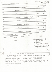 Whitehorse Historical Society Inc.
Document, Plan of Subdivision, 1861
Copy of plan of subdivision by Patrick RileyCopy of plan of subdivision by Patrick Riley of Section 77, Parish of Nunawading 'Springfield Township' 1861. Bounded by Whitehorse Road, Walker's Road, (now known as Springvale Road) and Springfield RoadCopy of plan of subdivision by Patrick Rileyland sales, riley, patrick, whitehorse road, nunawading, walkers road, springfield road, black street, robertson street, sandy street, burnt street, luckie street, bridge street, creek street, koonung street, thompson street -
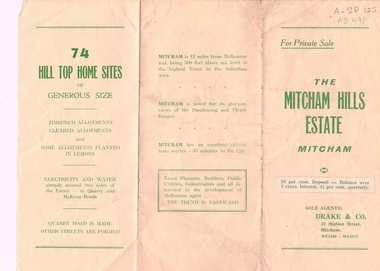 Whitehorse Historical Society Inc.
Document, Mitcham Hills Estate, n.d
Sale brochure for 'Mitcham Hills Estate',Sale brochure for 'Mitcham Hills Estate', 74 sites bordered by McKeon and Quarry Roads, to the order of Commander H.E. Turner and Mrs Turner. Agent: Drake & Co.. With 'List of Sale Prices'.Sale brochure for 'Mitcham Hills Estate',land subdivision, mitcham hills estate, mckeon road, mitcham, quarry road, endeavour street, moresby street, beaufort street, turner, harold exton, cmdr., (mrs), drake & co. -
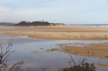 Lakes Entrance Historical Society
Photograph - Old Coach Rd 1910 and 2008, 1910c
This was a section of the coach road to Orbost in 1858. Also shown are two 2008 colour photographs of the same scene which were used in the before and after photograph 150 years Lakes Entrance 1858 to 2008 display held in 2008Black and white photograph of horse team pulling covered wagon across the bar at Lake Tyers which was a section of the coach road to Orbost at the time Lake Tyers Victoria. animals, transport, roads and streets -
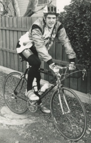
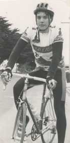 Lakes Entrance Historical Society
Photograph - Jerome Walters, Lakes Post Newspaper
road cyclist from Lakes Entrance nineteen year old Jerome Walters who rides up to one thousand kilometers per week Lakes Entrance VictoriaBlack and white photograph of road cyclist from Lakes Entrance nineteen year old Jerome Walters who rides up to one thousand kilometers per week Lakes Entrance Victoriasports, cycling, recreation -
 Lakes Entrance Historical Society
Photograph - Jerome Walters, Lakes Post Newspaper, 1/07/1993 12:00:00 AM
road cyclist from Lakes Entrance nineteen year old Jerome Walters who rides up to one thousand kilometers per week Lakes Entrance VictoriaBlack and white photograph of road cyclist from Lakes Entrance nineteen year old Jerome Walters who rides up to one thousand kilometers per week Lakes Entrance Victoriasports, cycling, recreation -
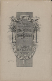 Glen Eira City Council History and Heritage Collection
Booklet, "AVENUES OF HONOUR The Councils of the Municipalities of the CITY OF CAULFIELD TOWN OF BRIGHTON acting in conjunction PUBLIC DEMONSTRATION SAT 3rd AUG. 1918 AT 3oCLOCK"
Souvenir Programme from the Councils of the Municipalities of the City of Caulfield and the Town of Brighton for a Public Demonstration to be held on Sat 3rd August 1918 at 3 o'clock for the proposed Avenues of Honour to be planted in memory of fallen WWI soldiers. From Honour Roll Display 2019 interpretation panel - Brighton-Caulfield Avenue of Honour It is hard to imagine but a grand arboreal Avenue of Honour once lined parts of North Road, McMillan Street and Point Nepean Road (now Nepean Highway). The Avenue of Honour was a distinctly Australian phenomenon with hundreds being constructed throughout Australia during and following World War One, most of these in Victoria. Consisting of tree lined streets with each tree representing a solider, the Avenue of Honour signalled a more egalitarian approach to commemoration where rank was not a consideration. Arguably the most famous Avenue of Honour in Victoria still exists at Ballarat. Stretching for nearly 22 kilometres, the entrance to the Avenue is marked by the imposing Arch of Victory. Smaller in scale, the Brighton-Caulfield Avenue of Honour was dedicated to the ‘memory of (Brighton and Caulfield’s) kith and kin who came from (the) district and who died in the Great War’. A joint project between the neighbouring Councils, the idea was first reported in The Argus on 1 July 1918. Plans moved along quickly and on 3 August 1918 the Governor of Victoria Arthur Stanley planted the first Australian flowering gum. The next of kin were then invited to plant trees for lost sons, brothers, uncles, nephews and husbands. In all, over 400 trees were planted. Intensely personal, the Avenue also acted as a focus of grief and remembrance for the wider community. For many years, the annual civic Anzac Day service was held at the Avenue on Point Nepean Road, near Glen Huntly Road, Elsternwick. The service was moved to Caulfield Park upon the completion of the Cenotaph in 1930. Due to road widening and disease the last original tree was replaced in the 1980s, however a plaque in Caulfield Park records the Avenue’s plantation. Commemorative booklet, grey cover with text printed on the grey textured paper cover and an image of four trees and a wreath. Image of a kookaburra on the back. Inside, 28 numbered pages with b/w text and photographic images including a transparent paper representation of the proposed Avenues of Honour on Brighton Road and Point Nepean Road. Souvenir programme for a Public Demonstration for the Avenues of Honour as detailed on the front.city of caufield, world war one, first world war, anzac, remembrance, town of brighton, brighton, caulfield, avenue of honour -
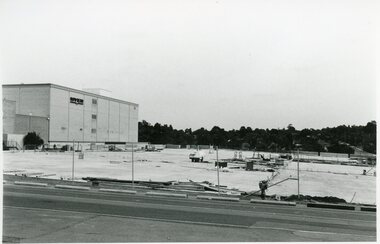 Ringwood and District Historical Society
Photographs, Eastland Car park Construction, Ringwood, 1992-93
B&W photograph taken by Ringwood Historical Research Group. Also added extract from Melways showing the roads before the Bypass (1987) showing the planned Bypass cutting these two roads, and Melways (2018) showing new alignment with Bypass11064A: 21.2.92 Eastland car park development from near Safeway 11064B: 21.2.92 Eastland car park development from Adelaide St 11064C: 4.1.93 Eastland car park development from Warrandyte Road from Op. Bond St. 11064D: 4.1.93 New Myer Eastland car park viewed from Safeway's Roof 11064E: 17.1.93 Eastland car park near where Esso Garage was 11064F: 21.2.92 Eastland car park from cnr of Adelaide St and Eastland -
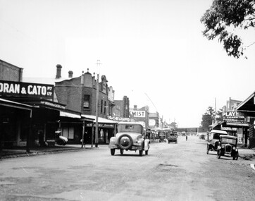 City of Kingston
Photograph - Black and white, c. 1925
This image explores the relationship between the train lines and community development. Cheltenham's retail centre is connected to the train station.Black and white image of Charman Road, Cheltenham, depicting a car and truck travelling toward the level crossing near the train station. There is another car already waiting at the crossing gates. Cars are parked on either side of the road along a shopping strip.Black printed text on a white round sticker adhered to the reverse: 141 Handwritten in red ink on reverse: 50% Black typed text on a white strip of paper adhered to reverse: Charman Road, Cheltenham / circa late 1920's/early 1930's / $50 reproduction fee applies Blue ink stamped on reverse: COPYRIGHT / Public Transport Corporation / For re-ordering photographs / Please quote negative ADV 485 / Enquiries C/- PTC Photographic Unit / Telephone switchboard 619 1111cheltenham, trains, railway, railway crossing, shopping strip, cars -
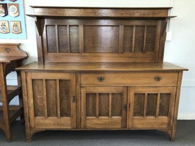 Mission to Seafarers Victoria
Furniture - Sideboard, Buffet, Heinrich Friedrich Fischer, 1909-1912
This sideboard was originally used in the dining room of the Manse, the chaplains' residence. Upon completion of the Institute building in 1917, the Goldsmiths moved in after living for many uncomplaining years in a flat on Australia Wharf, which had “many disadvantages and discomforts”. The stamps in the drawer indicate the furniture was manufactured by H.F Fischer (Heinrich Friedrich Fischer). His store is mentioned in many advertisings as manufacturer and seller of furniture and was located at the 322 City Road address between 1909 and 1912 and is listed in the Sands & McDougall's in 1910. From 1913 his address changed to 308-310 City Road. The ‘European labour only’ stamp was a legal requirement in Victoria where it was set out in the Factories and Shops Act of 1896. Its purpose was to distinguish between furniture made in Victoria by Chinese workers and that made by Europeans, meaning Australians of European origin. To distinguish them, the European stamp was square or rectangular, the Chinese stamp was trianguler.It is not known when they were purchased or gifted and by whom. The facture is of quality, as indicated by the tenon and mortise joints of the drawers. The Wellers photographed the dining suite during his stay betwenn 1926-1929 (see item 1568).Wooden Oakwood Arts and Crafts sideboard 2 rectangular Stamps in purple ink in the drawer: " Manufactured by / H.F. Fischer/ 322 City Road / European Labour Only"manse, heritage listed, sideboard, arts and crafts, english, h.f. fischer, european labour, heinrish friedrich fischer, cabinetmaker -
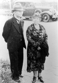 Surrey Hills Historical Society Collection
Photograph, Joe and Emily George of Scheele Street, Surrey Hills
Mrs Emily Ruth George of 26 Scheele Street, with husband, Joe. Emily & Joe were English migrants; they bought their home in 1919. Daughter Marie was born in 1914 when they are listed in the electoral roll at 'Hasland', Croydon Road, Surrey Hills; his occupation is given as a boilermaker. Emily (nee Sturgess) - d 15 November, 1960; buried Box Hill Cemetery - M-199A-0034 along with daughter Marie. Possible birth c Oct 1880, Birmingham (not confirmed); marriage c Jan 1905, Chesterfield, Derbyshire. Marie George became a school teacher and was on the staff at Chatham Primary School for a number of years. She died in February 1989. Mrs George was known for her hospitality. Anecdotes: On one occasion the government was to build six houses opposite in an area which was mostly paddocks. The materials were delivered and a caretaker allocated to guard them. He arrived with his wife to find a meagre tin shed as ‘home’. Mrs George responded by boarding the couple, for a very minimum amount for the six months. A rather different anecdote involves the droving of sheep from Lower Plenty across paddocks and tracks, through Doncaster and down Union Road to the station en route to the Richmond abattoirs. This was a seasonal activity and the men (and sheep) used to rest in the paddocks in Union Road, at the corner of Weybridge Street – behind the Georges’ home. When Mrs George heard the sheep, she would go out and fill the drovers’ billies with tea, handing out thick cheese sandwiches made from her homemade bread. A black and white photograph of a man and a lady dressed to go out and standing in the street. There is a car parked on the other side of the road in the background.(mrs) emily george, (mr) joe george, scheele street, surrey hills, mont albert, droving, clothing and dress, (miss) marie george, 'hasland', croydon road, (mrs) emily ruth george, (miss) emily ruth sturgess, box hill cemetery -
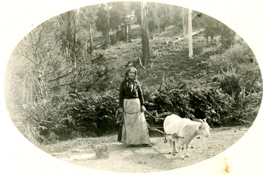 Mt Dandenong & District Historical Society Inc.
Photograph
Photograph likely taken on Childs Road in Kalorama in the early 1900s.Black and white photograph showing a woman with a long dress, apron and headscarf leading a got that is hitched to a small cart loaded with collected firewood. They are on a dirt road with bush above them. The photograph has been produced in postcard format with the picture in an oval in the centre of white frame.goat, wood collection, cart, wood, kalorama, childs road -
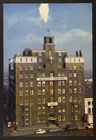 Mission to Seafarers Victoria
Postcard - Postcard, Colour
The Mission to Seamen Hostel, Victoria Dock Road, Londonsmall colour photographic postcard of Mission to Seafarers London, tear at top centre of postcardprinted info: Natural Colour / J. Arthur Dixon / Photogravure / Post Card / Printed and published by J. Arthur Dixon Ltd., Newport, I.W., England / The Mission to Seamen / Victoria Dock Road, London, E16 / SP 832mission to seamen, hostel, victoria dock, london, united kingdom, welfare, seamen, seafarers, sailors, accomodation, windvane, galleon, cars, overseas missions -
 Whitehorse Historical Society Inc.
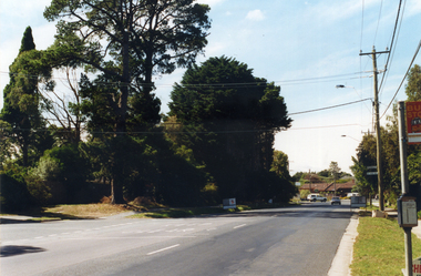
Map, Springvale Road, 1981
Aerial photograph of area including cnr. Springvale Road and Burwood Highway, south past Highbury Road and west to Sevenoaks Road.Aerial photograph of area including cnr. Springvale Road and Burwood Highway, south past Highbury Road and west to Sevenoaks Road.Aerial photograph of area including cnr. Springvale Road and Burwood Highway, south past Highbury Road and west to Sevenoaks Road.aerial photographs, burwood east, springvale road, burwood east, burwood highway, burwood east, sevenoaks road, burwood east, highbury road, burwood east -
 Whitehorse Historical Society Inc.
Photograph, Prior to Construction of Mitcham Road, 1/02/2000 12:00:00 AM
Coloured photograph of Mitcham Road looking towards Park Road with Wrendale Drive on left. Taken prior to widening of Mitcham Road.mitcham road, donvale, park road, wrendale drive -
 Whitehorse Historical Society Inc.
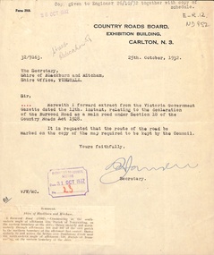
Letter - Correspondence, Burwood Road, 1/10/1932
Correspondence between Country Roads Board and Shire of Blackburn and Mitcham re declaration of Burwood Road as a main road, October 1932.burwood road, vermont south, victoria. country roads board, shire of blackburn and mitcham -
Canterbury History Group
Document - Elgar's Special Survey, part of, 1990
Photocopy of part of Elgar's Special Survey relating to the area between Mont Albert Road, Rochester Road and Faversham Road Canterburycanterbury, mont albert road, rochester road, faversham road, elgar's special survey, creeks -
 Kew Historical Society Inc
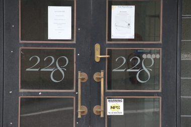
Photograph - Photographs (series), Richard Bowen, Sunninghill, 228 Cotham Road, 07/02/2020
'Sunninghill' at 228 Cotham Road (Kew) is an historically significant building due to its associations with Joseph Thomas (Bland) Holt (1851-1942), theatre entrepreneur and actor who lived at the house following his retirement in 1909. Sunninghill (aka Sunning Hill) was one of his residences in Victoria (also 'The Anchorage' at Sorrento). Following Holt's death at Sunninghill on 28 June 1942, the house was left to his wife. After her death the house was bequeathed to Lucy Coppin, daughter of George Coppin. The 'Shakespeare Window' in the State Library of Victoria was at one stage installed in the house. References 'Death of Mr Bland Holt: Great exponent of melodrama', The Argus, 30 June 1942, p. 3. Shoesmith D, 'Holt, Joseph Thomas (Bland) (1851-1942)', Australian Dictionary of Biography, Vol 4, 1972. 'The Shakespeare Window', State Library of Victoria website.Exterior photographs (digital) of Sunninghill, 228 Cotham Road, Kew VIC 3101. sunninghill - 228 cotham road - kew (vic), joseph thomas (bland) holt, lucy coppin -
 City of Kingston
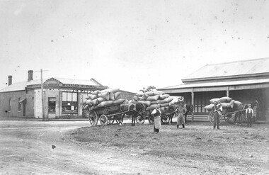
Photograph - Black and white, 1914
Judd's General Store was on the corner of Centre and East Boundary roads in East Bentleigh. This image shows unsealed roads at an intersection with loaded wagons for transporting (or recently transported). The building in the immediate background has a ghost sign which is now illegible. The photograph was apparently taken nine (9) days after the declaration of World War I. Orlando Judd is second from left.Black and white image of four men standing outside in front of three horse drawn wagons loaded with hessian bags. They are standing in front of Judd's General Store which was on the corner of Centre and East Boundary roads, East Bentleigh.White round sticker on reverse with black printed text: 79 Handwritten in red ink on reverse: 60%east bentleigh, horses, horse drawn wagon, commerce -
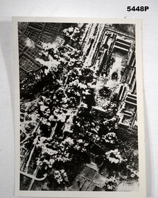 Bendigo Military Museum
Photograph - PHOTOGRAPH, AERIAL BOMBING, 1944.-1950
Refer to Cat 5445.2Black and white photograph taken during the bombing raid. In the phot can be seen rice paddies,train lines, roads and a camp of some sort, trenches .Rear Written” Nong Pladlik P.O.W camp 2nd bombing raid on camp Dec 3rd 1944 . 7 Killed Ist bombing on camp sept 7th 1944 93 Killed Stamp Imperial War Museum, Lambeth Road Wader S E 1 overwritten on stamp are some letters and 43976 ww2, p.o.w, thailand -
Whitehorse Historical Society Inc.
Document, McGlone's Estate Mitcham, 1/04/1921 12:00:00 AM
Copy of pamphlet of McGlone's Estate, Mitcham auctioned April 1921.Copy of pamphlet of McGlone's Estate, Mitcham auctioned April 1921. 24 allotments. Bordered by Whitehorse Road, McGlone Street, Station Street and Mitcham railway line and station. Original in Haughton maps, LaTrobe Library.Copy of pamphlet of McGlone's Estate, Mitcham auctioned April 1921. land sales, auctions, mcglone, john, mcglone, elizabeth, whitehorse road, mitcham, mcglone street, mitcham, station street, mitcham, mitcham railway station, haughton map collection, state library of victoria. latrobe library -
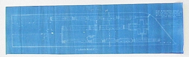 National Wool Museum
Plan - Machinery Layouts, J Dyson & Sons Pty Ltd
Two machinery plan layouts for Mimosa Wool & Textiles Pty Ltd in Hobson's Road, Kensington.1617.1 Rectangular blue paper with white lined plan drawing and white text 1617.2 Rectangular blue paper with white lined plan drawing1617.1 Front: Final Plan / PLAN OF MACHINERY LAYOUT / MIMOSA WOOL & TEXTILES PTY LTD / HOBSON'S ROAD KENSINGTON / BY MESSRS J DYSON & SONS / SOUTH GEELONG / Scale 3/32" - 1.0"factory, machinery, wool, textiles, mill, kensington, south geelong, plans, drawings, blueprint, layout, mimosa, j. dyson and sons pty ltd -
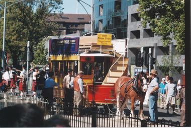 Ballarat Tramway Museum
Photograph - Colour Photograph/s - set of 3, Ray Marsh and Ron Scholten, 11/03/2002 12:00:00 AM
Yields information about the visit of Ballarat horse tram No. 1 to Melbourne for the 2002 Moomba Parade.Set of three colour prints of trams in Swanston St during the Moomba procession of 11/3/2002. See also Reg Item 2013 for other photographs. .1 - Horse tram with Len Millar alongside, in St Kilda Road, pending the start of the procession. Photo by Ray Marsh .2 - ditto, with people on board, prior to the horses being hitched up. V214 and HTT 8 alongside. .3 - ditto. Photographer of .1 and .2 unknown, possibly Ron Scholten. On rear of .1, "Ballarat 1, Moomba Parade, St Kilda Road 11.3.2" and the Ray Marsh stamp with address details.trams, tramways, horse trams, moomba, swanston st, st kilda road, tram 1, tram v214, tram htt 8