Showing 2016 items matching " met"
-
 Melton City Libraries
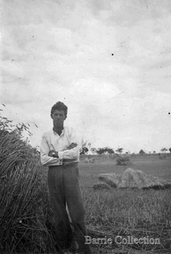
Photograph, Bon Barrie, c.1940, Unknown
SUMMARY - Ernest W (Bon) Barrie, 1909 – 1985 Profile Melton Mechanics Institute Member 1935 - 1982i Trustee 1952 - 1982 Life Member 1968 Years of service – 47 years He constructed and provided a public address system which was used at Melton and district halls and sports grounds for a wide variety of community events including school sports, gymkhanas, theatrical productions and processions. Fire Brigade Melton Fire Brigade (and predecessor Bush Fire Brigade) Apparatus Officer, 1945 - 1953 Captain, 1951 - 1965 Mt Cotterill Fire Brigades’ Group Elected Group Officer, on the formation of the Group, 1967. As Group Communications Officer he operated the VL3 LY base radio station from home on a 24 hour basis for fire brigades of Melton, Rockbank, Sydenham, Diggers Rest, Toolern Vale, Truganina and Werribee. With his brother Edgar, he built the first Melton Fire Truck. It was housed on the family property until a fire station was constructed in the Melton township. Recipient of the Queens Medal, 1979 Recognised for 44 years of service on the Melton Fire Brigade Memorial Wall Plaque, dedicated May 2013 Melton State School, no 430 Committee – School Correspondent (secretarial and financial role) 34 years of Service Provided his Amplifier Equipment for events and the annual district School Sports from 1939-1973. Donated the House Athletic Shield Melton and District Historical Society 1968 – 1985 President and foundation member Willows Historical Park – supported the establishment of the park and contributed many volunteers hours in the construction and landscaping of the precinct Member, Western Metropolitan Groups of Historical Societies, 1980s Shire of Melton Councillor South Riding, 1969-1971 Member of the Water Trust Melton Uniting Church Melton Uniting Church (and its predecessors the Methodist, Methodist-Presbyterian churches). A lifetime association which extended from childhood when he attended Sunday school until his death in 1985. Member of the Presbyterian Board of Management for more than 25 years in which he held positions of Honorary Secretary and Treasurer, Board member of the Parish Council and Member of the Committee of Management. He was a Sunday school teacher 1933. Community development With Mr RC Butler met with Shire Council in 1937 to canvass residents to ascertain prospective Electric consumers in the district. Electricity was subsequently turned on at dusk on 20th December 1939. Melton Progress Association, including Melton Musical, Elocutionary and Vocal Competitions, Vice President 1939 1940 Melton Development Association, 1960s Volunteer Air Observers Corps (VAOC)ii Carried out plane spotting at Shire Office and spotting tower in Melton and later from home until 1944/45. Agriculture and farming Progress and Better Farming Association, Melton. Honorary Secretary, 1935 Member, Agricultural Engineering Society Australia c1960-1985 A successful grower of wheat, oats and barley, he planted experiment plots and held Field Days on the “Darlingsford” property. He later diversified into other grains and sheep (wool and meat). He took a enthusiastic interest in agricultural engineering and was keen to introduce innovative ideas that improved the productivity of farms and farming practices. In the mid 1950 he conducted trials during harvest on the family property of the original mechanical hay fork built on a British Bedford truck by Bill Gillespie. This design was further refined in collaboration with the Gillespie brothers and resulted in the construction the hydraulically operated tractor mounted hay fork. The innovative design of the hay fork created interest from far and wide and was quickly taken up by farmers because it significantly reduced hand labouring of loading sheaves of hay with a pitch fork. His father established chaff mills in Melton, Rockbank, Parwan, Diggers Rest in the first decade of 1900 and in 1915 went into partnership with JR Schutt to establish the Schutt & Barrie Pty. Ltd. Chaff Cutting and Flour Mill in West Footscray. When it ceased trading in 1968 the directors were: Ernest W Barrie and Thomas L Barrie, R, A, and M Schutt. Awards Queens Medal, 1979 Rotary Award for Community Service, 1980 Victoria 150th Anniversary Celebrations contributions, 1985 Photographs of Bon Barrielocal identities, pioneer families -
 Eltham District Historical Society Inc
Photograph, Tess Justine (Nillumbik Shire Council), Construction work on replacement of Murray's Bridge over the Diamond Creek, Eltham North, 31 Mar 2022
Construction work on replacement of Murray's Bridge over the Diamond Creek on the Diamond Creek Trail Mary (Sweeney) Murray and John Wright Murray selected 80 acres, Lot C Section 16 and Lot 5 Section 17 Parish of Nillumbik, under an occupation license in 1866. John died in 1867 and freehold was granted to his son John in 1873. The farm was known as ‘Laurel Hill’. John Junior was an Eltham Shire councillor and sometime president from 1887 up until 1897. He added Lot A Section 16 to the farm in ca1888. John and his younger brother James arranged to rent/purchase Lot B Section 17, across Diamond Creek to the west, in ca1900. It appears that John and James farmed separately for a few years, with a new homestead built for James ad family on the high point of Lot B Section 17 in ca1910. John sold off Lot 5 Section 17 in 1912. When John died in 1912 James took over the land on both sides of the Diamond Creek. The old homestead on the west side of the Creek disappeared. A farm bridge over Diamond Creek from this period may have been located close to the northern boundary of the farm. John Langlands, owner of the farm known as ‘Ihurst’ on the west side of Diamond Creek to the south of the Murray’s land, died in 1907. In 1909 his land was then subdivided into 100 lots to become the ‘Glen Park Estate’. Other similar subdivisions of nineteenth century farms around Eltham in this period included the ‘Franktonia (or Beard’s) Estate’ to the northeast and ‘Bonsack’s Estate’ between Eltham and Greensborough. Soon after the opening of the railway extension line from Eltham to Hurstbridge in 1912, Glen Park and nearby residents including James Murray agitated for a railway station or siding to be located half-way between Eltham and Hurstbridge, so that the Glen Park residents who used the railway daily did not have to walk into the Eltham or Hurstbridge stations. Some believed Coleman’s Corner (opposite Edendale Farm) was an appropriate spot for the platform. James Murray was among those who thought the railway should be located on his land, closer to half-way between Eltham and Hurstbridge stations. The Railways Commissioners warned that the locals would have to fund these works themselves. The Glen Park Estate residents initially had difficulty accessing Eltham by road, with only an old low-level bridge over Diamond Creek at the south end of their estate. A new timber trestle bridge across the creek, now on Wattletree Road, was opened in 1915. Road access to the north was gained in 1927 when the new Murray’s Road, which crossed the Murray’s land, was built. Residents continued to agitate for a Glen Park station. By 1926 the Railways Commissioners’ preferred site was on the Murray’s land. They arranged an estimate of cost of a full-length platform. The estimate was too much for the locals, who in 1928 argued unsuccessfully for a shorter and hence cheaper platform. By 1929 Murray had agreed to donate the land, but the locals would still have to fund the works. Murray decided, unilaterally it would appear, to commence work on a timber trestle road bridge over Diamond Creek to link the new Murray Road to the proposed station. Late in 1929 he stopped work on the bridge, for reasons unknown, but started work again and completed the bridge in 1931. There is no further newspaper evidence of the campaign for the Glen Park station until 1939, when Murray and another local, Mr Maxwell, met the Railways Commissioner. The Glen Park locale now included 45 homes on the west side of the creek and 20 on the Eltham side. Most of the residents used the train every day. The Commissioner remained adamant that only a full-length platform could be built for safety reasons. It appears the campaign dissolved at this point. The increasing move to cars may have had an impact. There is no evidence of Murray’s bridge ever being connected to Murray’s Road, or of it having wide use for any purpose by locals. James Murray died in 1947 and the farm was taken over by his son James (Jim). Jim started to sell off parts of the farm in the 1980s, retaining a few acres around the ca1910 homestead and building a new house there. Recreation reserves were established along the creek. In ca1990 Murray’s bridge was renovated with steel girders as part of a bike/pedestrian path in the reserve. The old farmhouse was demolished in ca2014. Born digital image (5)diamond creek (creek), diamond creek trail, murrays bridge, ‘laurel hill’, john wright murray, mary (sweeney) murra, john murray jnr, james murray, john langlands, ‘ihurst’, ‘glen park estate’, beard's estate, franktonia, bonsack's estate, glen park estate, glen park railway station -
 Melton City Libraries
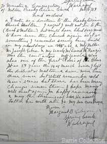
Letter, Letter from Margaret B Gibson, 1928/2014
David McKenzie obituary, Romsey Examiner 1928 Another of Australia’s very old pioneers in the person of Mr McKenzie, passed away last weekend at his daughters residence At regent at the ripe old age of 92 years ( he would be 93 in November) Born at Berwick of Tweed Scotland, the late Mr McKenzie arrived in Australia with two of his uncles in 1855 by the ship “Red Jacket”. A stone- mason by trade he worked about Melbourne and at Geelong until attack by “gold fever” but met with no success at this venture so he returned to his trade, arriving at Melton about 1860. There he married and settles for about 20 years. In 1880 the Cherokee Heights with its subdivision was famous and Mr McKenzie moved there with his daughter. He continues in his trade, his work extending to Gisborne, Bacchus Marsh, Romsey, and Springfield and other places, where to this day, may be seen monuments of his skill and through tradesmanship as a mason. During his residence in the Mount, he took a keen interest in all the affairs of Kerrie and Cherokee, and he was a familiar figure at all the public gatherings at which he nearly always filled the position of Chairman, because of outstanding qualifications. He was a man of those sterling qualities possessed by those men who laid the foundation of this country so well and truly. Loyal, broad of vision, just in thought and deed, honourable to the extreme in all dealings, fearless in the cause of right, a lover of home and family, and ready to lend a hand to all progressive movements. To the memory of those grand men the youth of today should lift their hats in reverence. Mr McKenzie was a prolific reader of educational works, and the wonderful knowledge he retained upon a variety of subjects was a source joy to those who associated with him. His wife predeceased him by 43 years ago soon after arrival in Cherokee. A Pioneer of Melton There are probably some residents left at Melton and Bacchus Marsh who will remember the late Mr McKenzie, one of them has written as follows:- I knew the late Mr. McKenzie since I was a little boy – over 50 years ago- and no better man ever lived than he, he was a good man from every point of view. The late Mr McKenzie was born on the November 25th, 1835 at Montrose, Scotland. He came to Australia in 1853 and resided for a time with his uncle the late Mr. Gibson on the Kororoit Creek near Melton. A few years later he settled in Melton. In 1861 he was married to Miss Mary Buchanan, the eldest daughter of the late Mr. George Buchanan, one of the early settlers of Melton. Deceased resided on the main road to Bacchus Marsh one mile from Melton. He was a stone- mason by trade, and some fine buildings in Melton and surrounding districts to this day, stand to his credit. He built the Presbyterian Church Melton. The old school, the Shire Hall, many private dwellings and numerous bridges. He was highly respected, as he was well known for the good work he put into all he had to do with. He also took numerous contracts in the Melton Shire, and was also employed by the Shire as Clerk of Works. He was a most conscious man. In his day he took a prominent part in all public affairs, and was a leading spirit in the old school Board. He was one of the pioneers of the Melton Rechabite Tent. He was one of the earliest workers and supporters of the Melton Presbyterian Church, of which he was an elder, and for a great number of years, its Sunday School Superintendent and Teacher. He also lead the singing for many years before the days of the organ, as he had a splendid voice, and could sing his old Scotch songs and hymns up to within six months of his death. For the past five years he has resided with one of his daughters at north Preston, where he died. He had good health up to within six months of his death and could well remember all the early happenings at Melton and surrounding districts. There are five daughters and one living son:- Margaret Mrs. Walter Wyatt Twose of Burnley Elizabeth Mrs George Shebler of Brunswick Georgina Mrs Jack Sinclair Isabel Mrs H Knight of North Preston Jane Mrs William Gibson of Warragul John W. of Fremantle - Western Australia Letter from Margaret to the Melton Presbyterian Churchchurches, local architecture -
 Flagstaff Hill Maritime Museum and Village
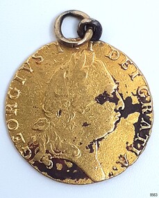
Currency - Guinea Coin, The Royal Mint, 1793 George III Spade Guinea, 1793
The coin was discovered by Julie Wilkins, a Victorian scuba diver who had already experienced more than 500 dives in Australia and overseas. She was holidaying in Peterborough, Victoria, and looking forward to discovering more about the famous Loch Ard ship, wrecked in June 1878 at Mutton Bird Island. The fast Glasgow-built clipper ship was only five years old when the tragedy occurred. There were 54 people on board the vessel and only two survived Julie's holiday photograph of Boat Bay reminds her of her most memorable dive. Submerged in the calm, flat sea, she was carefully scanning around the remains of the old wreck when, to her amazement, a gold coin and a small gold cross suddenly came up towards her. She excitedly cupped them in her hands, then stowed the treasures safely in her wetsuit and continued her dive. She soon discovered a group of brass carriage clock parts and some bottles of champagne. It was a day full of surprises. The items were easily recognisable, without any build-up of encrustations or concretion. Julie secretly enjoyed her treasures for twenty-four years then packed them up for the early morning train trip to Warrnambool. After a short walk to Flagstaff Hill Maritime Museum and Village, her photograph was taken as she handed over her precious find. She told her story to a local newspaper reporter, lunched a café in town then took the late afternoon train home. Her generous donation is now part of a vast collection of Loch Ard shipwreck artefacts, including the gold watch and the Minton Majolica model peacock. The coin is a British 1793 George III Gold Spade Guinea. It was already 83 years old when the Loch Ard had set sail. The loop and ring have been added, perhaps as a pendant, pocket watch accessory or similar purpose. It may have been worn for ‘good luck’ on the long journey to Australia, where ships had to carefully navigate the treacherous Bass’s Strait before arriving at their destination of Melbourne. Sadly, many met their fate on that short stretch of ocean aptly named the Shipwreck Coast. The coin is very recognisable even though it was exposed to the wrecking of the ship, its consequent movement, and the sea's turbulence. Its bent, scratched, buckled, split, dinted and worn condition is part of its story. The red-brown-black discolouration is similar to that found on other gold coins, sometimes called the ‘corrosion phenomena’. Studies suggest the possible cause is contaminants in the minting process reacting to the coins’ environment. The GEORGE III GOLD SPADE GUINEA: - The British Guinea was introduced in 1663 and was circulated until 1814. It was made of 22 carat gold, was 25 to 26 cm in diameter and weighed 8.35 grams. It had a value of 21 British shillings. The guinea coin ceased circulation after 1816 and was replaced by the one-pound note. However, the term ‘guinea’ continued to represent 21 shillings. King George (1738-1820) had six gold guinea designs minted during his reign from 1760 and 1820. Each of the six had different obverse portraits, all facing the right. There were three different reverse sides. The Spade Guinea was the fifth issue of the coin, introduced in 1787 and produced until 1799. The reverse shows a royal crown over a flat-topped shield with the Royal Arms of Great Britain, used in Scotland between 1714 and 1800. The shield images are, from left to right, top to bottom, the Arms of England and Scotland, the Arms of France, the Arms of Ireland, and the Arms of the House of Hanover. The Gold Guinea is also part of Australia’s history. It was the first coin mentioned in the announcement of Governor King of New South Wales his Australian Proclamation of a limited variety and denomination of coins accepted for use in the Australian Colony. The historic and decorative George III Spade Guinea has been reproduced for special collections of coins. However, replicas and imitations have also been made as souvenirs for tourists, as gaming tokens and chips for gamblers, and as ‘fake’ coins for profit. These coins differ in many ways; they may be only half the weight of the genuine coin. Often have a small stamp on the obverse with “COPY” or the manufacturer’s name or initials. Some have scalloped edges, some have dates that are different to the original dates of issue, and some even have text in Latin that translates as something very different to the original coin.The King George III Guinea was only produced from 1663 to 1814 and was the first English coin to be mechanically minted. The coin is the fifth edition of the King George III Guinea, the Spade Guinea, was only produced between 1787 and 1799. It is the only edition with this portrait of King George and the only one with the Royal Coat of Arms of Great Britain in Scotland on the reverse side. This edition was also the last guinea in circulation, because the sixth edition was reserved as the Military guinea. This edition of the Guinea is unique; This coin is the only guinea in our collection. It was minted in 1793, so it is now over 230 years old. The Gold Guinea is part of Australia’s history; it was the first coin in the list of coins for use in the Australian Colonies, mentioned by Governor King of New South Wales in his Australian Proclamation speech of 1800. The George III Spade Guinea was included in the Limited Edition Sherwood 12 Coin Collection of Notable Coinage of Australia. This coin is the only known guinea coin recovered from the wreck of the Loch Ard. It was already 85 years old when the ship was wrecked.Gold coin; British. 1793, King George III of the United Kingdom of Great Britain and Ireland (1760-1820), Spade Guinea. Yellow gold coin with gold metal loop mount and a gold ring through the loop. The design is the fifth issue of the George III Gold Guinea. The obverse relief is a portrait of George III facing right. Reverse relief is a crown above the Coats of Arms (1801-1816) of flat top spade-shaped shield divided into four quadrants that depict crowned lions, fleur de lies, a harp. These images are identified as, from left to right, top to bottom, England and Scotland, France, Ireland and Hanover. Inscriptions are minted around the rims of each side. The coin is dated 1793. Its surface has dark areas on both sides and the reed edge and surfaces are well worn. The loop mount is bent and the ring is buckled. The coin was recovered from the wreck of the ship Loch Ard.Obverse text; 'GEORGIVS III DEI GRATIA' (translates to George the Third, by the Grace of God) Obverse relief; (King George III bust, facing right, laurel wreath on head) Reverse text; 'M.B.E.ET.H.REX.F. D.B.ET.L.D. S.R.I.A.T.ET.E' '1793' (translates to: King of Great Britain, France and Ireland, Defender of the Faith, Duke of Brunswick and Lüneburg, Arch-Treasurer and Elector of the Holy Roman Empire) Reverse relief; a spade-shaped image i.e. (Crown with fleer de lies, above Shield with crowned lions in different postures, a harp, and other details)flagstaff hill maritime museum and village, warrnambool, great ocean road, shipwreck coast, royal mint, british coin, currency, guinea, military guinea, australian currency, british guinea, gold coin, spade guinea, king george iii, george iii, fifth portrait, arms of england and scotland, arms of france, arms of ireland, arms of the house of hanover, coins, gold coins, gold medallion, georgian era, 1793, numismatics, contamination phenomena, gold corrosion, good luck, lucky charm, pendant, lucky coin, trade, loch ard, wreck of the loch ard, 1878, mutton bird island, peterborough, scuba diver, 1980s, guinea coin, gold guinea, shipwreck artefact, relic, julie wilkins -
 Melbourne Tram Museum
Ephemera - Olympic Scrap book, "MMTB #1", 1987 to 2003
Collection of newspaper clippings pasted into the scrapbook by the donor. Covers the period 1979 to 1990 when the Melbourne tram system underwent large changes. All from The Herald Sun or The Sun, unless noted otherwise. Contains the following cuttings: 1 - New tram link proves popular - Progress Print 12/12/1979 2 - Extension for tram? Standard 28/11/1979 3 - Ban trams from mall call - Herald - 14/12/1979 4 - Its war on tram yobbos - Sun 25/4/1980 5 - A bus drivers' dream sale 6 - Art lovers in transport of delight - The Bulletin 3/4/1979 7 - Your turn: Our Red cars are gone and all but forgotten - Los Angeles Herald Examiner 21/6/1978 8 - Push for tram line - Eastern Standard - 3/12/1980 9 - Photo of the opening of Bundoora line - 19/5/1983 10 - From cable cars to electric trams - Reg Baird - City Extra 13/11/1985 11 - Louie fears he'll soon be history - Sun 12/11/1985 12 - The first tram rolls unofficially of course - Box Hill Gazette - 18/7/1978 13 - Then and now - Board looks back to 1916 - Box Hill Gazette - 18/7/1978 14 - Blockade - trams buses choke city - 20/7/1987 15 - What a clangers - Tranquil city of trammies, and a City of the Rails - 21/7/1984 16 - Trammies on the buses - 24/7/1984 17 - A tram voted a winner - Progress Press 17/10/1984 18 - A class trams - Eastern Standard 23/10/1984 19 - Danton Carson - ex cable trammie - 12/11/1985 20 - Tram line upgrade - 10/9/1985 21 - Launch of B1 2001 - 16/11/1984 22 - Home built from trams - Progress Press - 9/11/1983 23 - A shortcut on the Brunswick line - Malcolm tram on Miller St bridge - 22/8/1985 24 - Stone and brick and cable tram - The Age 2/11/1985 25 - Danton Carson article by Lahey at Large - The Age 9/11/1985 26 - Why not a City tram loop? - 21/11/1986 27 - tram route ruling angers commuters - (route 82) - 4/1/1986 28 - History back on the tracks - photo o W1 612 - 3/8/1987 29 - The last number 77 - The Age 8/1/1986 30 - Art on wheels (tram 336) - Progress Press 10/12/1986 31 - Ban on Trams - Kew Depot - Progress Press 10/12/1986 32 - The Ghosts of Brisbane Past - Brisbane Courier Mail - 9/10/1987 33 - Trammies had to be tough in the days of cable cars - The Herald - 11/11/1985 34 - Catch a vintage tram at Bylands - 11/11/1985 35 - Aboard the trams home - 26/8/1987 36 - The end of the line for a private tram fleet - 28/3/1989 37 - Jim's tram plan clangs to a halt 38 - Red nose trams in a class of their own 39 - PTC Statewide Open Day - 17/10/1991 40 - Trams a vital part of city's transport - 18/5/1988 41 - Fun tram just the ticket -15/3/1988 42 - Desire is a streetcar for Jim, a collector obsessed 0 8/3/1988 43 - Tram crash 31 hurt - 7/2/1989 44 - Tramway exhibition to roll - Progrss Report - 18/10/1989 45 - Business on the right line - Restaurant tram - 30/10/1989 46 - Experience the 'real' tram museum on a shaky ride - 17/6/1989 47 - The start of electric trams - progress press 18/10/1989 48 - Trams Back - fights erupt as trammies vote - 2/2/1990 49 - Tram row legacy to linger on - 2/2/1990 50 - Trams back, but travelers aren't - Progress Press - 14/2/1990 51 - advert by The Met - Trams operating today - 8/2/1990 52 - Trams roll - rebe;'s rage still a threat - Z33 3/2/1990 53 - An early tram catches a few passengers - Month before all trams back - 5/2/1990 Yields information about the Melbourne tram network in the 1990sScrap book - Olympic - 32 plain sheets + printed card covers, centre stapled.tramways, melbourne, newspapers, box hill, tram museums, unions, tram blockade, a class, east burwood, bundoora, cable trams, b class, route 82, route 77, danton carson, brisbane, restaurant tram, adelaide -
 Eltham District Historical Society Inc
Film - Video (DVD), Frank Stokes, Stokes Family, 1950-1977
Various family scenes taken from outside the family home on the southeast corner of the intersection of Nyora Road and Pitt Street with Eucalyptus Road. Also, scenes of the Stokes Orchard and equipment used, construction of water reservoir at the end of Nyora Road near Reynolds Road and Diosma Road as well as early stages of the Stokes Orchard housing development. Frank Stokes worked as a qualified accountant at Kennons leather factory in Burnley, while living at 1 Thomas Street, Mitcham. He suffered from migraines and wanted to go back to the land (he had previously worked on farms and orchards since coming to Australia in 1926 both in WA and Vic.). He first travelled to the district by train in July 1942 to find land with the intention to establish an orchard. By chance he met Arthur Bird of Bird Orchard (bounded by Pitt Street, Eucalyptus Road and Wattle Grove) and they got talking over their common interest. Arthur put Frank up for the night and pointed out the land, 158 acres- Taylor Estate- £900, part of Crown Allotment 15, Section 5, Parish of Nillumbik (CA15) somewhat diagonally opposite Bird Orchard. He applied through the Riverina Agency to purchase the land who in turn had to get permission from Canberra to sell as there was a new government regulation banning land sales except for immediate production. He obtained a loan on his Mitcham house of £600 @ 5% and paid £450 deposit with quarterly payments of £15 over 5 years. The title to the property was issued May 15, 1946. He was helped and advised by Arthur Bird who farmed the neighbouring orchard. Early 1943 he took possession and would catch the train out to Eltham on Fridays after work and began building a hut for shelter and to lock up tools. He was able to pay a neighbour (Hawkins) to help with clearing and fencing 25 acres and with a horse and single furrowed plow, planted approximately 2,500 fruit trees - cherries, peaches, plums, almonds, pears, apricots and lemons as well as a few apples and oranges; a massive job. A huge problem was hares and rabbits eating all the new buds off the tiny trees. As well as laying poison he painted the trees with a mixture of cow manure and lime. Often working by moonlight. It was extremely difficult to get wire and wire netting because of the war but after much effort he obtained a permit from the Agricultural Department for supplies in March 1944. In February 1945 he applied for a permit to build a “packing shed” as no house building allowed. It was to be 33 feet x 21 feet and cost £312. Constructed mostly from second-hand materials, which was hard to obtain, especially iron for roofing. Frank finished work at Kennons October 31, 1945, and in March 1946 he sold the Mitcham house for £1230 plus £170 for furniture. The family of five then moved into a very unfinished at Eltham, which was a struggle to weatherproof. Eventually rooms were divided off and lined with hessian bags and whitewashed. Their income was firewood (cut and sold), selling rockery stones and cut sweet bursaria. (It was discovered during the 1940s that Bursaria contained the sunscreen compound Aesculin. The RAAF utilised this compound from Bursaria during WW2 for pilots and gunners.) The orchard’s first fruit sale was a 1/2 case of Le Vanq peaches in December 1947 - 8 shillings. In 1956 plans for house were drawn and Glen Iris bricks purchased (1956 Olympic Rings variant). The building of the house commenced in 1957 - 12 feet of original packing shed removed – and was completed in 1959. Water was connected from newly built pressure storage on the property at the end of 1959 and the electricity connection for the first time at 3pm on April 29, 1960. In the mid-1970s the Shire of Eltham divided the orchard up into numerous rate-able parcel lots, which became unaffordable for Frank. Consequently, Stokes Orchard was turned into a housing development by Macquarie Builders and marketed as the Stokes Orchard Estate in two stages; Stage 1 encompassing Scarlet Ash Court, Ironbark Close and Peppermint Grove bounded by Nyora and Eucalyptus roads c.1976 and Stage 2 encompassing Stokes Place, Orchard Way, The Crest and The Lookout bound by Nyora and Diosma roads c.1979. The development of Orchard Way, The Crest and The Lookout did not proceed as planned due to the lack of the sewer along Diosma Road and so many of the proposed lots were incorporated into five-acre parcels instead. With the arrival of the sewer along Diosma Road many years later, most of these five-acre parcels have since been subdivided many times.Representative of the orchard growing areas of ElthamMP4 00:24:39; 426MB Digital file only - Digitised by EDHS from a DVD copy on loan from Beryl Bradbury (nee Stokes), daughter of Frank Stokes. 24 min duration compilation of home movie Super 8mm film shot by Frank Stokes brother-in-law.beryl bradbury (nee stokes) collection, frank stokes, nyora road, stokes orchard, stokes orchard estate, stokes place, video recording -
 Ballarat Clarendon College
Book, The watches of the trails
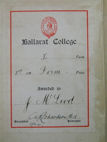
John Anning MacLeod John was born in Ballarat as the second generation of Ballarat MacLeod’s, with his grandfather arriving in Geelong on the Hornet in 1857 as an 11 year old child with his 60 year old father John and mother Mary aged 37 years and 5 brothers and one sister. He grew up on the corner of Drummond Street and Mair Streets, opposite what became St John of God hospital, at his parents house of Dunvegan. John entered Ballarat College as a junior student in 1923. He received 3rd in Form prizes in both 1924 and 1925. His sister Margaret, attended Clarendon Ladies College. The household employed a chauffeur, a cook, a gardener and a ladies maid to care for them. In the 1930’s his father lost his fortune in the collapse of the jute future’s market so the staff were dismissed and he left Ballarat to go to Geelong College as a boarder. He was an officer in the Geelong College cadet corps and joined the Army as a private and rose to the permanent rank of Major after meritorious performance in the intelligence area of operations. He served in North Africa, in Palestine, Egypt, Moratai, the Philippines, Java and New Guinea. He was awarded his Military MBE by King George VI for exceptional devotion to duty and for brilliant coordination work amongst the allied intelligence team. During the war he met Mary Monica Carrol Bateman, a lietenant in the 2/4th Army General Hospital at a dinner party in Brisbane. The couple had four children, Hamish John Torquil born in 1945, Rory Hugh Alexander born in 1947 and twins Ian Donald and Katriona Margaret born in 1948. After the Second World War he worked for Lumley’s Insurance Brokers in London for a couple of years to follow up his accountancy training and then returned to Ballarat due to his father’s failing health and took over the management of John MacLeod and Co, Wholesale grocers and Merchants in Lydiard Street, Ballarat. The business had been started by his great grandfather and they produced the famous Sirdar brand of products and a special tea blend called Afternoon Cup. There was a spice mill in nearby Market Street and there they roasted peanuts, coffee and ground spices for packaging and distribution to the small corner shops who were the mainstay of commercial grocery. In the 1950’s John MacLeod and Co merged with James McKay and Sons to form McKay MacLeod Pty Ltd., wholesale tobacco, wine and spirits and grocery merchants who also manufactured the Sunny South brand of sweet mustard pickles, brewed vinegar and tomato sauce. He introduced the semi-automated system for extensions and financial records on the Bradma plates that saved staff the problems of sorting out the calculations for sales tax, miscellaneous charges etc. that greatly sped up the transactions at the checkout points. A new warehouse and office complex was built in Mair Street east up near Humffray Street, with the manufacturing factory on the opposite side of the street. They had a shop in St Arnaud and one in Geelong which was the local wholesaler for supplying to the corner shops of the greater Geelong area. With the development of supermarkets the demise of the corner store began and so the sales profiles began to diminish. He unsuccessfully stood for Liberal Party pre-selection for the seat of Ballarat in 1948 and served on the Liberal state finance and executive team for many years before resigning over the issue of conscripts being sent to Vietnam. He was instrumental in leading a group of Ballarat academics in opposition to the Vietnam war and publicly resigned from the Liberal Party over their foreign policy. John MacLeod saw the writing on the wall of the business in the early 1970’s and suggested that the firm restructured with focusing on tobacco, wine and spirits. His partners did not agree and so he sold out and retired to Barwon Heads. After a few years of golfing and surfing he became frustrated and joined SCORE, the Service Corp of Retired Executives. In this role he worked for ten years in the Geelong area solving accounting problems for Geelong small businesses and so helped Beaumont’s bakery back onto its feet. He worked gentlemen’s hours of 10 am to 3 pm which allowed him to have time for a round of 9 holes on the golf course at the end of the day and to have a surf before breakfast. He fully retired at the age of 65 and had ten years of voluminous reading of local library books before dying of burns at the age of 75. His war record has been documented in other archives at the College. He was a member of the Naval and Military Club and of the Barwon Heads Golf Club. He had good crafting skills and built a series of steam driven boats for his four children that used to be sailed at home on Lake Wendouree, Lake Learmonth and on the sheltered waters of the Barwon River. The boats are now being restored to operational order to be sailed by his great grandson Grayson Girardi. Red cloth bound book with title printed in gold lettering on spine, embossed publisher's mark centre of front cover and school crest in gold relief on front cover; book plate inside front cover. Book plate inside front cover: School crest / Ballarat College / I form / 3rd in form Prize / Awarded to / J MacLeod / December 1924 A Richardson B A Principaljohn-macleod, ballarat-college, book-prize, 1924 -
 Ballarat Clarendon College
Book, The school across the road
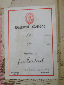
John Anning MacLeod John was born in Ballarat as the second generation of Ballarat MacLeod’s, with his grandfather arriving in Geelong on the Hornet in 1857 as an 11 year old child with his 60 year old father John and mother Mary aged 37 years and 5 brothers and one sister. He grew up on the corner of Drummond Street and Mair Streets, opposite what became St John of God hospital, at his parents house of Dunvegan. John entered Ballarat College as a junior student in 1923. He received 3rd in Form prizes in both 1924 and 1925. His sister Margaret, attended Clarendon Ladies College. The household employed a chauffeur, a cook, a gardener and a ladies maid to care for them. In the 1930’s his father lost his fortune in the collapse of the jute future’s market so the staff were dismissed and he left Ballarat to go to Geelong College as a boarder. He was an officer in the Geelong College cadet corps and joined the Army as a private and rose to the permanent rank of Major after meritorious performance in the intelligence area of operations. He served in North Africa, in Palestine, Egypt, Moratai, the Philippines, Java and New Guinea. He was awarded his Military MBE by King George VI for exceptional devotion to duty and for brilliant coordination work amongst the allied intelligence team. During the war he met Mary Monica Carrol Bateman, a lietenant in the 2/4th Army General Hospital at a dinner party in Brisbane. The couple had four children, Hamish John Torquil born in 1945, Rory Hugh Alexander born in 1947 and twins Ian Donald and Katriona Margaret born in 1948. After the Second World War he worked for Lumley’s Insurance Brokers in London for a couple of years to follow up his accountancy training and then returned to Ballarat due to his father’s failing health and took over the management of John MacLeod and Co, Wholesale grocers and Merchants in Lydiard Street, Ballarat. The business had been started by his great grandfather and they produced the famous Sirdar brand of products and a special tea blend called Afternoon Cup. There was a spice mill in nearby Market Street and there they roasted peanuts, coffee and ground spices for packaging and distribution to the small corner shops who were the mainstay of commercial grocery. In the 1950’s John MacLeod and Co merged with James McKay and Sons to form McKay MacLeod Pty Ltd., wholesale tobacco, wine and spirits and grocery merchants who also manufactured the Sunny South brand of sweet mustard pickles, brewed vinegar and tomato sauce. He introduced the semi-automated system for extensions and financial records on the Bradma plates that saved staff the problems of sorting out the calculations for sales tax, miscellaneous charges etc. that greatly sped up the transactions at the checkout points. A new warehouse and office complex was built in Mair Street east up near Humffray Street, with the manufacturing factory on the opposite side of the street. They had a shop in St Arnaud and one in Geelong which was the local wholesaler for supplying to the corner shops of the greater Geelong area. With the development of supermarkets the demise of the corner store began and so the sales profiles began to diminish. He unsuccessfully stood for Liberal Party pre-selection for the seat of Ballarat in 1948 and served on the Liberal state finance and executive team for many years before resigning over the issue of conscripts being sent to Vietnam. He was instrumental in leading a group of Ballarat academics in opposition to the Vietnam war and publicly resigned from the Liberal Party over their foreign policy. John MacLeod saw the writing on the wall of the business in the early 1970’s and suggested that the firm restructured with focusing on tobacco, wine and spirits. His partners did not agree and so he sold out and retired to Barwon Heads. After a few years of golfing and surfing he became frustrated and joined SCORE, the Service Corp of Retired Executives. In this role he worked for ten years in the Geelong area solving accounting problems for Geelong small businesses and so helped Beaumont’s bakery back onto its feet. He worked gentlemen’s hours of 10 am to 3 pm which allowed him to have time for a round of 9 holes on the golf course at the end of the day and to have a surf before breakfast. He fully retired at the age of 65 and had ten years of voluminous reading of local library books before dying of burns at the age of 75. His war record has been documented in other archives at the College. He was a member of the Naval and Military Club and of the Barwon Heads Golf Club. He had good crafting skills and built a series of steam driven boats for his four children that used to be sailed at home on Lake Wendouree, Lake Learmonth and on the sheltered waters of the Barwon River. The boats are now being restored to operational order to be sailed by his great grandson Grayson Girardi. john-macleod, ballarat-college, 1925, book-prize -
 Eltham District Historical Society Inc
Photograph - Digital Photograph, Alan King, Original Kangaroo Ground Primary School No. 2105 building, Eltham-Yarra Glen Road, Kangaroo Ground, 28 December 2007
Kangaroo Ground's first school began in 1851 with 22 pupils from the district's ten families. It was a single room school located further south on the site, which also served as a Presbyterian church. The first teacher was Andrew Ross. The school building was used as a Post Office between 1854 and 1858 and during 1857 also served as a Court of Petty Sessions. With a growing farming community, a new building was warranted and the original Sate School No. 352 was closed and a new building, State School No. 2105 was oipened October 1, 1878. A residence for Head Teacher Henry Wallace School was erected in 1879 attached to the left of the school building. That residence is now home to the Andrew Ross Museum, which opened in 1993. Covered under Heritage Overlay, Nillumbik Planning Scheme. Published: Nillumbik Now and Then / Marguerite Marshall 2008; photographs Alan King with Marguerite Marshall.; p35 In a corner of the Kangaroo Ground Primary School playground stands an old weatherboard building. This structure, attached to the former teacher’s weatherboard residence facing Main Road, first served as a school in 1878. The former residence, built in 1879, houses the Andrew Ross Museum, which opened in 1993. It is named after the school’s first teacher,1 who also founded The Evelyn Observer newspaper, which began on the site in 1873. Later the printing presses were moved to brick newspaper offices by the Kangaroo Ground Hotel, which became the Shire of Eltham offices. However Kangaroo Ground’s first school began in 1851 for 22 pupils from the district’s ten families, in a slab building further south on this site. Andrew Harkness and other settlers campaigned for the building, which was built on half an acre (0.2ha) donated by local farmer, James Donaldson. Builder was Samuel Furphy, father of the novelist Joseph.2 The single room measuring 30 feet x 18 feet (9m x 5.5m), was unlined and the green slabs shrank, allowing the wind and rain entry through cracks except when they were stuffed with paper.3 The building served as a Presbyterian church as well as a school, where fees were 18 pence a week for education. Young men also attended evening classes there in winter. At one stage, a corner of the room was curtained off for the schoolmaster’s living space, and the platform, which was used for sleeping, was also the pulpit during church services. Teacher Andrew Ross also took church services when the minister was unable to attend, which happened frequently as he had long distances to travel on the bad roads. In 1857 the school building was also used as the Court of Petty Sessions, and from 1854 until 1858, it served as a post office. During the gold rush fossickers on their way to the Caledonia Diggings at Queenstown (now St Andrews) prospected the district, but did not remain long, as the fields were not rich in gold. But the farming community grew, until by 1878 the population warranted the building of State School No 2105 – the present one-roomed tongue-and-groove lined building measuring 49 feet x 18 feet (15m x 5.5m), to accommodate 60 children. The old school, No 352, was closed, and the new one opened on October 1, with Henry Wallace as head teacher, assisted by work mistress Annie Johnston. Early teachers included Messrs Smith, Hamilton and Prosser, with sewing teachers Misses Sweeney, Limerock and Oliver. In the early 1920s a small room was built on the front veranda of the teacher’s residence, and used as a State Savings Bank agency until about 1934. In 1928 the schoolroom’s three-tiered floor was replaced by a flat floor and teacher’s platform (which has since been removed). A half-glassed partition wall then divided the large room into two rooms in which the old style form-type desks were replaced with dual desks. The small playground, surrounded by pine trees and a picket fence, was extended in 1931 with an additional acre or so (0.4 ha) of land. During World War Two the school faced closure because of a fall to seven in the enrolment, but by 1946 it had increased again to 45. Mr Eric Morgan was head teacher and Mrs Margaret Banks was assistant head teacher, a position she held for ten years. In 1955, under the head teacher Mr V Gardiner, who taught there for 13 years, the school won a prize for the best-kept garden and school ground in the inspectorate. A district subdivision increased the enrolment in 1968 to 65 and a bus service was established. After the hall which had been used for lessons was demolished late that year, the pupils met in the original fire brigade meeting room (now the tennis club, diagonally opposite the general store). The new school building with a storeroom and staffroom was built in 1974.This collection of almost 130 photos about places and people within the Shire of Nillumbik, an urban and rural municipality in Melbourne's north, contributes to an understanding of the history of the Shire. Published in 2008 immediately prior to the Black Saturday bushfires of February 7, 2009, it documents sites that were impacted, and in some cases destroyed by the fires. It includes photographs taken especially for the publication, creating a unique time capsule representing the Shire in the early 21st century. It remains the most recent comprehenesive publication devoted to the Shire's history connecting local residents to the past. nillumbik now and then (marshall-king) collection, kangaroo ground, andrew ross museum, eltham-yarra glen road, kangaroo ground primary school no. 2105, kangaroo ground state school, state school no. 2105 -
 Eltham District Historical Society Inc
Photograph - Digital Photograph, Alan King, St Andrews Anglican Church, St Andrews, 30 January 2008
Built c.1868, St Andrew’s Anglican Church is Nillumbik Shire’s oldest timber church and is historically, socially, and spiritually significant to the Shire of Nillumbik. The church is historically significant because it may have given its name 'St Andrews' to the town (another suggestion is that the name came from the local hotel), it is also historically significant as one of only four buildings that remain from the Caledonian goldfields era of Queenstown (now St Andrews) and one of only a handful of buildings that survived the 1960s bushfires. The church is historically, socially, and spiritually significant because it has played an important part in community life for more than 150 years; a proposal to move the church in 1984 met with strenuous opposition. Much of the fires on Black Saturday 2009 were the north of the town. The town itself remained intact - as did this heritage building. Covered under Heritage Overlay, Nillumbik Planning Scheme. National Trust of Australia (Victoria) Local significance Published: Nillumbik Now and Then / Marguerite Marshall 2008; photographs Alan King with Marguerite Marshall.; p69 The St Andrews Anglican Church and former St Andrews Primary School, are two reminders of the district’s early days, when it was founded on gold. St Andrews, then called Queenstown, was the earliest goldfield in the Caledonia Diggings.1 It was the Upper Diamond Gold Mining and Administrative Centre, with 3000 miners. Queenstown was also the seat of the Court of Petty Sessions. The church and school then stood close to European and Chinese stores, three hotels, a brewery and a quartz mill.2 In 1861, Queenstown was officially proclaimed a township. From 1865, the name Queenstown was interchangeable with St Andrews, until 1952, when the town was officially named St Andrews. As gold declined from the early 1880s, Queenstown changed dramatically into a settlement of small farms. St Andrew’s Anglican Church, built in 1868, is the Shire’s oldest timber church and possibly gave its name to the township.3 The small timber church was opened on November 1, 1869, by the Dean of Melbourne. Anniversary tea meetings helped raise funds, and in 1889, a three-bedroom parsonage was built alongside. In 1910, the vicar, the Rev Selwyn Chase (and friend of the Scouting Movement’s founder, Baden Powell), established the 1st Queenstown Scout Troop, only two years after Scouting began in Australia. The church was important to the lives of many local residents who were baptised, married and had funeral services there. But by the 1950s the population had decreased and so did the weekly attendances. Around the mid-1960s the church closed, then fell into disrepair. So in the mid 1980s it was sold to the Education Department and was under threat of relocation or demolition. However this caused such opposition from locals,4 that instead, the Anglican church leased it as part of the Panton Hill parish5 and it was reconsecrated in 1987. Queenstown’s first school was held in a tent after transferring from Andersons Creek, Warrandyte.6 From 1858 a church school, Caledonia Diggings, stood west of the main road, a quarter of a mile (0.4km) before Buttermans Track. In 1882 the school was moved from a leased building, owned by headmaster Robert Harris, into a larger building on the corner of the School and the Heidelberg-Kinglake Roads. It had been moved from Smiths Gully and included a teacher’s three-roomed residence.7 In 1887 the school was replaced by the Queenstown State School No 128, although it was also called Caledonia Diggings until 1891. In 1956 it was renamed St Andrews. Still standing, this building is now used as the St Andrews Community Centre and the residence is leased for private use. The original timber-lined room remains alongside the extensions, and is distinctive with its high ceiling and tall small-paned windows. In 1984 a new school was built 500 metres west of the old school. Many residents have contributed much to St Andrews but one family that has done so for several generations is the Harris family. Robert Harris was an active member of the St Andrew’s Anglican Church, and worked hard at improving the town’s amenities until his death in 1887. He was a signatory to the successful 1863 petition to the Chief Commissioner of Police, against the proposed removal of the Court of Petty Sessions and police station at the Caledonia Diggings. The police station stayed in the town until 1917. Harris was Head Teacher of Queenstown State School from 1864 to 1874, then of the Smiths Gully school until it closed in 1882, and he continued teaching at Panton Hill until his death. His son, Robert Charles Harris, was editor and printer of the local newspaper, The Evelyn Observer, from 1873 until 1915. Robert’s son, William Shelley Harris, served in the Boer War and in World War One. In 1928 he became Kinglake National Park’s first park ranger. Robert’s daughter Elizabeth, taught needlework at Queenstown State School, and later ran the post office in Kinglake.This collection of almost 130 photos about places and people within the Shire of Nillumbik, an urban and rural municipality in Melbourne's north, contributes to an understanding of the history of the Shire. Published in 2008 immediately prior to the Black Saturday bushfires of February 7, 2009, it documents sites that were impacted, and in some cases destroyed by the fires. It includes photographs taken especially for the publication, creating a unique time capsule representing the Shire in the early 21st century. It remains the most recent comprehenesive publication devoted to the Shire's history connecting local residents to the past. nillumbik now and then (marshall-king) collection, st andrews, st andrews anglican church -
 Ringwood and District Historical Society
Document, State School 4688 Heathmont, c 1969
S.S, No 4688, Francis Street, Heathmont, 3135 History Two A4 pages of notes on the beginnings of the Heathmont S.S The text is:- STATE SCHOOL No 4698 Frances Street Heathmont, 3135 HISTORY School classes at Heathmont commenced in the original Methodist Church building in Canterbury Road in 1952 with Mr A.J. McKinlay as Head Teacher in charge of a school of 80 pupils. Shortly afterwards both a Parents and Citizens Association and the first School Committee were formed. Mr J.B. Harper was appointed as president of the Association and Mr H. Walker was elected as chairmen of the Committee, while Mr T. Jago acted as secretary to both bodies. Later in that same year the district Inspector, Mr H. Fleigner since retired and still a Heathmont resident, woe instrumental in obtaining a site for the establishment of the present Heathmont School at the corner of Frances Street and Balfour Avenue. The land was purchased from Mr. Handasyde, an orchardist of Wantirna South. In March 1963 a Bristol prefabricated aluminium building comprising four classrooms and an office was occupied. On April 21st, 1953 the school was opened officially by the Minister for Education, the Hon. A.E. Shepherd MLA. By December of that year the attendance had increased to 191 pupils, Mr N. Gillham was Head Teacher at the time. In February 1955 Mr. K. Gerraty succeeded Mr Gillham and by 1957 attendance had risen to 326 pupils necessitating the provision of additional light timber construction classrooms. Meanwhile the subdivision of large areas of local orchard land into housing estates with its resulting rapidly increasing population presented a persistent school accommodation problem that was met temporarily by the hiring of district church halls to accommodate a steadily rising attendance. Fortunately the tradition of voluntarily contributing to school funds and voluntarily providing labour initiated by the original parent bodies in 1952 was maintained. Then Mr V. Milligan commenced as Head Teacher in 1959, much of the steeply contoured playground area had been terraced, a football oval formed and the basketball court and assembly areas were sealed. These improvements were finally completed largely due to the enthusiasm, vigor and work effected by the School Committee under the chairmanship of Ringwood Councillor Mr JM McRae, as is borne out by the following report by Mr R.J. Chapman, District Inspector in 1961. "The local support by parents given to the Head Teacher and his staff is exceptional and I express my appreciation of their outstanding service." Mr Milligan's contribution to progress, however, lay equally in the internal educational development, particularly with regard to the teaching of reading. A course in the mechanics of speed reading, involving the use of the tachistoscope reading rate controllers and programmed comprehension sets was introduced and a start was made in the building up of a library of literature and reference books. As a result the Education Department appointed a Teacher-librarian to ensure continuity and further progress with this Reading scheme. A feature of Heathmont School is the splendid modern Art/Craft room opened while Mr L. Sebire was head teacher in 1966. This building and courtyard, linked to the original building by a covered way was designed by Mr Salvatore who acted as honorary architect, and was completed by Mr John F. Swan at a cost of �10,000 of which 52% was provided by a School Committee Co-operative loan and 42% by Departmental special grant. Materials used were white sandstone brick and oregon pine. The building bears the name of Councillor J.M. McRae Art Centre as a tribute to the man who did so much to enable its construction. An Art/Craft specialist teacher is provided by the Education Department. As attendance continued to increase to 520 children in 1969, additional accommodation became an urgent necessity. Following negotiations conducted by Mr A. Lethbridge School Committee President, Mr JJ Egan, former Principal and the present Principal, Mr A.S. Don the Education Department Assisted by a second Committee Co-operative loan, purchased the adjacent Baptist Church property thus providing much needed extra accommodation and playground area The newly acquired building is at present in use as two temporary classrooms, but will subsequent be used as a utility rope. A smaller room has been converted to a canteen operated daily by the Parents and Citizens Association, thus providing both a service to the pupils and a source of income. +Additional Keywords: McKinlay, Mr.A G Harper, Mr J.B Walker,Mr.H Fleigner, Mr.H Handasyde, Mr. G Shepherd, Hon. A.E. MLA Gillham, Mr.K Garraty, Mr.K Milligan, Mr.V McRae, Mr. J.M. Chapman,Mr.R.J. Sebire,Mr.L Salvatore,Mr. Swann,Mr.John F. Lethbridge, mr.A Egan,Mr.J.J. Don,Mr.A.S. -
 Bendigo Historical Society Inc.
Document - SPECIMEN COTTAGE COLLECTION: VARIOUS DOCUMENTS
In 1853, Bendigo Miners protested against the 30 shilling miners licence the had to pay the government. They wore red ribbons to show their protest and shopkeepers hung red ribbons outside their premises in support. Thousands of miners signed a petition to Governor LaTrobe to no avail. A protest gathering in Pall Mall marched to the Government camp on Camp Hill but this was a peaceful event again to no real avail.Various documents. The topics are: 4029.1 Public donations and organised charities in Bendigo (1850's to 1900's by Carol Holsworth. 4029.2 The spirit of Bendigo R711 and the loco driver on the return trip from Bendigo by Rod Giri, also several photographs of the train. 4029.3 Diary of a new chum - Johnny Greenfield Gill. 4029.4 Family history by Pat Hocking. 4029.5 The story of the Gaylards as told by Ella Gaylard. 4029.6 Journalism- History first draft by Wayne Gregson. 4029.7 List of residents of Thistle Street, Bendigo approx. 1950's compiled by Cynthia Stringer. 4029.8 Sandhurst club history by David Cotton. 4029.9 Sandhurst boys centre compiled by Brian Dillon. 4029.10 Lily Street Walk 24/04/2018 notes by Jim Evans. 4029.11 Document - All things Bendigo, wine food and music fest. 4029.12 White Hills Sandhurst copies of maps and two pages of district directory1908. 4029.13 Draft report of interview with Noel Smith of 5 Summit Drive, Kennington. 4029.14 Three brothers from Scotland by Rae Alexander Anderson. Also, seven newspaper articles by James Lerk on William, Alexander Rae and John Rae. 4029.15 St. John Presbyterian church, Bendigo. Historical record. 4029.16 Journal of Thomas Llewellyn Raston. 4029.17 Recollections of Sandhurst in the 1850's - Joseph Anderson Panton, 22 segments from Panton manuscript by Terry Davidson. Also, a photographs of a portrait of Joseph Panton. 4029.18 Photocopy of letter of Chinese storekeepers, miners and residents to Joseph Anderson Panton esquire, resident warden of Bendigo dated August 28th, 1858, with transcription and the reply from Esquire Panton dated 29 August, 1858. 4029.19 View street reborn, tours of inspection ''welcome to View Street'' view Street properties part of stage 1 of the project: National Trust Chambers, Temperance Hall, Art Gallery Annexe, Trades Hall, Bendigo Regional Arts Centre, Bendigo Regional Performing Arts Centre, Dudley House. 4029.20 View Street early 1900's in between and now. From handwritten notes by Mr. Bob Carr written in 1989. The handwriting has been transcribed by Beverly Ellis. 4029.21 Transcription of ''Diary of a voyage to the colony of Victoria and back'' June1856-September 1858 by Charles Groves. 4029.22 Adelaide Vale historic homestead built by Cr. John Harney. Tour notes prepared by the Central Victorian Branch of the National Trust. 4029.23 Four pages essay titled Spanish Tomato Growers. 2440.29. Eight pages of notes compiled by Leonard Henderson title: Trade token issuers of Bendigo district. The issuers mentioned are: Grieve, Hodgson, Stead and Williams. 4029.25 City of Bendigo tourist promotion Committee. Eight pages document describing the formation of committee for the promotion of tourism in the City of Bendigo. 4029.26 Article ''The Birdman of Bendigo'' Bendigo Advertiser 17th January 1968 detailing the life of Mr. Redvers James Eddy. 4029.27 Speech presented by Miss Margaret Brennan on the occasion of the Drechsler family reunion, Sunday 5th April 1987. 4029.28 Robert Gray Ford - A man before his time! Talk by James Lerk to the Bendigo Historical Society 3 February 2006. 4029.29 Copy of an article from The Bendigonian Annual from November 16, 1910. The demand for good music, how a Bendigo firm has met it. The article is about the life of Oscar Flight. 4029.30 Five photocopies of the Bendigonian masthead showing the changes through the years, plus the notice of the final issue on April 8th, 1920. 4029.31 The red ribbon rebellion & the Bendigo petition, a proposal to commemorate a significant event in Bendigo. Also three different sizes poster for the August 26, 2016 re-enactment and two invitations to join the red ribbon agitation memorial. 4029.32 Two handwritten pages of notes on the red ribbon rebellion. 4029.33 Three pages of typewritten notes on the Creeth and Howie families. 4029.34 An Australian Edward Medallist - Joseph Davies honoured by Paul Street. 4029.35 A. H. Chisholm obituary. 4029.36 Catalogue auction sale of the entire collection of antique furniture, objects d'art etc of Mr. and Mrs S. Cragg. 4029.37 Two coloured photographs of Cherry Tree Hotel in Melbourne Road just north of Tuckerman's lane, Big Hill. Photos taken March 2000 by Joan Paynter. bendigo, red ribbon rebellion -
 Bendigo Historical Society Inc.
Document - PETER ELLIS COLLECTION: LETTER BUSH DANCE AND MUSIC CLUB BENDIGO, 28th February 2011
3 Page Letter printed on A4 printer paper. Bearing the letterhead of the Bush Dance and Music Club of Bendigo Inc. Postal Address Secretary PO Box 922 Bendigo 3552 Telephone number (03) 5442 1153 email [email protected] Mark Maddock Case Officer Australian Honours and Awards Secretariat Government house Canberra ACT 2600 28th February 2011. Dear Mark, Thank you for giving us the opportunity to speak for Peter Ellis. We know Peter to be a worthy candidate for the award and I think that most people that know him would agree. I had been putting together a nomination for Peter that was suggested by a couple at our club meeting on a night when Peter was not present. Everyone felt that he should have recognition for all the work that he has done and it was unanimously voted on. I was given the job. As someone else has beaten me to it I now can speak for him on my own behalf and in my role as secretary of the Bush Dance & Music Club Inc. Peter Ellis is a very good friend of mine and I have known him since April 1975 when we met at a Saturday night dance. At that time there was a small group of us that went around the dances. We would go 100kms to find dances that were not on the average programme, dances such as The Lancers, Albert's, Waltz Cotillion and lots of Polkas. We bemoaned the fact that they appeared to be dying out in the Towns and Cities so we tried to get the Bendigo Old Time Dance Club of which we were members, to introduce these dances on to the programme, but they were not interested. After a lot of discussion Peter, Maurie Rayner, myself and several others decided to start our own dance club where we could do the dances that we liked, and to endeavour to keep them alive. We formed the Sandhurst Dance Club in June 1979 (renamed ten years later as the Bush Dance & Music Club of Bendigo Inc.) In 1981 Peter made two attempts to form a band for the club and in 1983 the 'Celebrated Emu Creek Bush Band' was born, with Peter as the leader. Later Peter set up a junior section of the Emu Creek Band and some of these children grew up to become competent musicians and leaders of their own bands/Groups. Peter's friendship with the late Harry McQueen of Castlemaine led to and increased knowledge of the dances, calls for the sets and the various tunes used. Peter joined the Wedderburn Old Timers Orchestra in late 1979 and travelling around Victoria and interstate with them was of immense help in learning to MC dances, call sets acoustically and in collecting new 'old dances' and tunes. He met elderly MC's who gave him information on the way that they ran the dances in the old days. It was also an introduction to playing items at concerts and in reviving much of the old traditions of the bush. Demand for the tunes for dances led to Peter compiling a series of three books called 'Collectors Choice' which were published by the Victorian Folk Music Club in 1986, 1987 and 1988. 1988 was a very busy year for Peter and The Emu Creek Bush Band as they recorded two double music tapes for the club 'The Merry Country Dance' and 'The Waltz the Polka and all Kinds of Dancing' which were in much demand at the time. Also in 1988 he collaborated with the late Shirley Andrews and they co-authored the book 'Two Hundred Dancing Years and how to celebrate them with a Colonial Ball' for the Bicentennial of 1988. this publication, was instigated by the Government backed Bicentenary Committee, and distributed free to every municipality in Australia. In 1996 The Emu Creek Bush Band and Peter recorded and produced a single CD called a Friday night at 'The Spring Valley Hop'. In 1998 The Bush Dance & Music Club again happily agreed to financially back Peter to produce a series of CDs. The first thing he did was to revive and update the 1988 music tapes for CD. The first of the Qadrille Mania series of double CDs with companion call books was launched in 1999 then in 2000 and 2001. then the triple CD called The Waltz Polka & all kinds of Dances in 2002 followed by the Merry Country Dance CDs in 2005, 2006 and 2007. There were six double CDs and one triple CD produced which was a major undertaking that went on for eight years. The CDs have a great many tunes that Peter collected over the years mixed in with well known tunes and there are very few repeats. During this time we applied for a Grant from the Victorian Government to publish a book on the social History of country dances and dance instructions with Peter as the author. We were successful and published it in 2005. Our CDs and book have all been lodged with the National Library of Canberra as has all Peter's sheet music, boxes of it, as well as everything he has produced. At the 2005 Canberra National Folk Festival, at a meeting of collectors, it was stated that Peter has the largest collection of dance related material in the National Library. Peter compiled and produced his own project a triple CD called 'Take Me Back to Bendigo' in 2002. 2006 Peter and Emu Creek Bush Band produced another single CD 'Bush Concert Vol one Back to Goornong'. 2008 A pet project of Peter's was compiling and producing a double CD for the Wedderburn Old Timers it was of all the recorded material performed by them at concerts and taped by friends and fans. It was funded by Gavan Holt a son of the late Lindsay Holt an original 'Old Timer'. Recent publications are a book mainly music 'Music Makes Me Smile' a tribute to Con Klippel and the music of the Nariel Valley near Corryong Victoria. Peter Ellis & Harry Gardner 1998. The Waltz, The Polka & All Kinds of Dancing' a sheet music book for musicians supported by the Folk Song & Dance Society of Victoria. 2007-8 not sure of year. Peter has been involved over the years in collecting music and dance by himself and also with Rob Willis and the late John Meredith for the National Library in Canberra. He is continually asked for information and to write articles for people and to verify points re dance and music. He corresponds with like minded people overseas and frequently goes off to Folk Festivals all over the country, usually running dance classes, musician's workshops or just playing for dances. He is an excellent musician and plays Piano, Button Accordion, Concertina, Mouth Organ, Tin Whistle, Ukulele, Spoons and the Bones. He is regarded as one of Australia's foremost collectors and presenters of Australian traditional dance tunes, dances and some musical instruments. Over the years I have heard him referred to as the Guru of folk dance and music. Peter lives and breathes for this passion of his and always has several irons in the fire. He is a life member of The Bush Dance & Music Club of Bendigo Inc. The Victorian Folk Music Club, and The Bendigo Field Naturalists Club. He was a recipient of the David Squance Award in 1994 presented by the Folk Song & Dance Society of Victoria. Over the last twelve months for the folk magazine 'Trad & Now' he has written articles on the old dances and music and this is an ongoing project. This has led to our clubs present project which is the filming of the dances to be shown on UTube as it is referred to in the magazine. This involves members in hours and hours of practising the dances then filming them, and all with Peter's expert teaching and watchful eye on everyone. The Bush Dance & Music Club are and always have been behind Peter wholeheartedly in everything that he does and we are extremely proud of what he has achieved. His drive and enthusiasm for the preservation of music and dance is catching. People like Peter are absolutely necessary in finding and preserving our Australian Heritage, without them it would be lost forever and Australia would be a great deal poorer for it. The Bush Dance and Music Club of Bendigo Inc. and I fully support this nomination for an award as he is truly deserving of it. Yours sincerely Mary E Smith. Secretary of the Bush Dance & Music Club Inc. Peter's Timeline. 1979 A Foundation Member of the Bush Dance & Music Club of Bendigo Inc. 1979 Joined the Wedderburn Old Timers Orchestra. 1983 The Celebrated Emu Creek Bush Band was formed. 1986 Collectors Choice. Volume one. 1987 Collectors Choice. Volume Two. 1988 Collectors Choice. Volume Three. 1988 Recorded Tapes - The Merry Country Dance & The Waltz Polka & all Kinds of Dances. 1988 A book with the late Shirley Andrews called Two Hundred years of Dancing. 1991 Across to Perth collecting for National Library with the Late John Meredith. 1996 Single CD A Friday Night at the Spring Gully Hop. 1998 Music Makes Me Smile. A tribute to Con Klippel 7 music of the Nariel Valley. 1999 Double CD Quadrille Mania 1&2 2000 Double CD Quadrille Mania 3&4 2001 Double CD Quadrille Mania 5&6 2002 His own project triple CD Take Me Back To Bendigo. (Goldrush to Federation and Beyond). 2002 Triple CD The Waltz The Polka & All kinds of Dances. 2005 Double CD The Merry Country Dance 1 & 2. 2002 Book, The Merry Country Dance. 2006 Single CD with Emu Creek 'Bush Concert Vol 1 Back to Goornong' 2006 Double CD The Merry Country Dance 3&4 2007 Double CD The Merry Country Dance 5&6 2007-8-? A book of music, The Waltz, The Polka & All Kinds of Dances. 2008 Double CD The Wedderburn Old Timers in Concert.person, individual, peter ellis oam -
 Eltham District Historical Society Inc
Photograph, Hume and Hovell passed here at Seymour 28 Oct 1824, Spring Excursion, Hume and Hovell's 1824 expedition (Part 2), 26 October 1997, 26/10/1997
[article by Diana Bassett-Smith in EDHS Newsletter No. 117, November 1997:] MONUMENT HUNTING THE HUME AND HOVELL WAY - Sunday October 26 1997 dawned bright and very warm. Some twenty-five members, complete with picnic baskets, met outside the Eltham Library awaiting the Cobb and Co. large coach which would be taking us on the second leg of our travels along the route of the early explorers Hume and Hovell. Stephen West was our very good driver for the day. He would be guided around the circuitous route by Russell Yeoman who had made a detailed study, not only of the intended route, but of the story of these two explorers. During the trip Russell regaled us with poetry, quotations from the Journals and the History of the Shire of Seymour, "The New Crossing Place" by Martindale, 1982, (now Mitchell Shire due to the recent amalgamations). We headed towards the Hume Highway via Greensborough and Cooper Street and proceeded north to our first stop, noting on the way Monument Hill in the distance which is near Kilmore and, according to Russell, well worth the effort to visit as the view across the valley is magnificent. Past Sunday Creek Valley, Mt Piper and Mt Disappointment, all traversed and noted and named by them. We passed through Tallarook, then onto Seymour where we took photos of the monument telling us that Hume and Hovell had passed through on the 28th of October 1824. We also deviated down Hume and Hovell Road viewing deer and emu farming and the Bellbourie property now a sanctuary. Leaving Seymour behind we travelled up the Avenel Road to the Avenel monument, pyramidal in design of four reducing square blocks with a sharply pointed peak, erected in 1924 in memory of the 1824 exploration. The day was warming up and the countryside showing the dryness of the current drought. A parallel note had been made in their journal too of 1824 of the drought appearance of the country they were traversing. At Seven Creeks, Euroa we stopped for some minutes to check the monument placed 20th November 1924 to commemorate their passage on the 29th December 1824. More photos. Russell had pointed out the abrupt termination of the distant ranges which is noted in their journal. The next monument is beside the road at the entrance to Honey Suckle Creek Caravan Park, Violet Town. The squarish shaped monument some eight feet high is topped with a simple steel cross, and was to mark the date of 28th December 1824 and built for the 20th November 1924. By now it was 12.20 and nearly lunchtime as we drove along the Warranbayne Road to Roach's Road, monument hunting without success. Though there is a large, what appears to be an old timber sign which was hard to read, maybe this was the lost monument. In many of the paddocks hay had been cut and baled or was being cut, what a contrast to the rugged country they had passed through which was smoky from the fires of the natives burning off. By 1.00 pm we were at Benalla and pulled up beside the park where abundant beds of roses filled the air with their scent and the smell of barbecued food twitched the nostrils whilst the cheerful sounds of other picnickers could be heard throughout the park. We left the bus and collected up our picnics, dispersed to the various tables and enjoyed the shade from the various European trees. 2.00 pm and we were on the road again driving along the Benalla, Mansfield, Yea road. The Swanpool monument states that they passed four miles south and returned three miles north. Then we stopped at the Barjarg monument which notes that they camped near this spot. It is again a pyramidal monument and this time topped with a steel arrow indicating their route of the 29th November 1824. Half an hour later we came to another monument, again with a steel arrow marker on top and the plaque dated the 2nd of 12th 1824. Erected on the 12th of 12th 1924. "They blazed the way that we might inherit the land." Another square based and needle topped monument appeared at Yarck near Yea and this plaque records the date of 3 December 1824. Near McGuigans Road Russell related that the expedition had lost a dog but it had found them next day, the dog was apparently torn by a kangaroo. A short while later Russell reminded us here of the problems they encountered in crossing the Goulburn River near Molesworth where banks were high, water deep and wide. "Good coat of grass but quite dry due to drought". At Yea we stopped for afternoon tea and raided the last of our picnics and looked at the monument to their journey of 1824, situated at a corner of the gardens near the bowling green. No photo – we were out of film. We returned home via Kinglake West and Whittlesea past the Yan Yean Reservoir, not full. 5.00 pm back at Eltham we emptied out of the bus and everyone, including Joan Cole, collected their things, Joan also had the major souvenir of the day, a large carp she had picked up from the river bank, her cat was in for a great feast. The day was made so interesting by the informed commentary which Russell provided. His background knowledge of the route and nature of the journey could only have come from many hours of reading and driving the area. Thank you to Russell and to everyone who made the day so informative and pleasurable. Colour photographactivities, hume and hovell, monument, seymour -
 Eltham District Historical Society Inc
Photograph, Spring Excursion, Hume and Hovell's 1824 expedition (Part 2), 26 October 1997, 26/10/1997
[article by Diana Bassett-Smith in EDHS Newsletter No. 117, November 1997:] MONUMENT HUNTING THE HUME AND HOVELL WAY - Sunday October 26 1997 dawned bright and very warm. Some twenty-five members, complete with picnic baskets, met outside the Eltham Library awaiting the Cobb and Co. large coach which would be taking us on the second leg of our travels along the route of the early explorers Hume and Hovell. Stephen West was our very good driver for the day. He would be guided around the circuitous route by Russell Yeoman who had made a detailed study, not only of the intended route, but of the story of these two explorers. During the trip Russell regaled us with poetry, quotations from the Journals and the History of the Shire of Seymour, "The New Crossing Place" by Martindale, 1982, (now Mitchell Shire due to the recent amalgamations). We headed towards the Hume Highway via Greensborough and Cooper Street and proceeded north to our first stop, noting on the way Monument Hill in the distance which is near Kilmore and, according to Russell, well worth the effort to visit as the view across the valley is magnificent. Past Sunday Creek Valley, Mt Piper and Mt Disappointment, all traversed and noted and named by them. We passed through Tallarook, then onto Seymour where we took photos of the monument telling us that Hume and Hovell had passed through on the 28th of October 1824. We also deviated down Hume and Hovell Road viewing deer and emu farming and the Bellbourie property now a sanctuary. Leaving Seymour behind we travelled up the Avenel Road to the Avenel monument, pyramidal in design of four reducing square blocks with a sharply pointed peak, erected in 1924 in memory of the 1824 exploration. The day was warming up and the countryside showing the dryness of the current drought. A parallel note had been made in their journal too of 1824 of the drought appearance of the country they were traversing. At Seven Creeks, Euroa we stopped for some minutes to check the monument placed 20th November 1924 to commemorate their passage on the 29th December 1824. More photos. Russell had pointed out the abrupt termination of the distant ranges which is noted in their journal. The next monument is beside the road at the entrance to Honey Suckle Creek Caravan Park, Violet Town. The squarish shaped monument some eight feet high is topped with a simple steel cross, and was to mark the date of 28th December 1824 and built for the 20th November 1924. By now it was 12.20 and nearly lunchtime as we drove along the Warranbayne Road to Roach's Road, monument hunting without success. Though there is a large, what appears to be an old timber sign which was hard to read, maybe this was the lost monument. In many of the paddocks hay had been cut and baled or was being cut, what a contrast to the rugged country they had passed through which was smoky from the fires of the natives burning off. By 1.00 pm we were at Benalla and pulled up beside the park where abundant beds of roses filled the air with their scent and the smell of barbecued food twitched the nostrils whilst the cheerful sounds of other picnickers could be heard throughout the park. We left the bus and collected up our picnics, dispersed to the various tables and enjoyed the shade from the various European trees. 2.00 pm and we were on the road again driving along the Benalla, Mansfield, Yea road. The Swanpool monument states that they passed four miles south and returned three miles north. Then we stopped at the Barjarg monument which notes that they camped near this spot. It is again a pyramidal monument and this time topped with a steel arrow indicating their route of the 29th November 1824. Half an hour later we came to another monument, again with a steel arrow marker on top and the plaque dated the 2nd of 12th 1824. Erected on the 12th of 12th 1924. "They blazed the way that we might inherit the land." Another square based and needle topped monument appeared at Yarck near Yea and this plaque records the date of 3 December 1824. Near McGuigans Road Russell related that the expedition had lost a dog but it had found them next day, the dog was apparently torn by a kangaroo. A short while later Russell reminded us here of the problems they encountered in crossing the Goulburn River near Molesworth where banks were high, water deep and wide. "Good coat of grass but quite dry due to drought". At Yea we stopped for afternoon tea and raided the last of our picnics and looked at the monument to their journey of 1824, situated at a corner of the gardens near the bowling green. No photo – we were out of film. We returned home via Kinglake West and Whittlesea past the Yan Yean Reservoir, not full. 5.00 pm back at Eltham we emptied out of the bus and everyone, including Joan Cole, collected their things, Joan also had the major souvenir of the day, a large carp she had picked up from the river bank, her cat was in for a great feast. The day was made so interesting by the informed commentary which Russell provided. His background knowledge of the route and nature of the journey could only have come from many hours of reading and driving the area. Thank you to Russell and to everyone who made the day so informative and pleasurable. Colour photographactivities, hume and hovell, bridge -
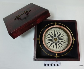 Flagstaff Hill Maritime Museum and Village
Functional object - Compass, mid-19th Century
Captain Robilliard: James Arthur Robilliard was a sea captain and tentmaker, born on the 19th April 1843 at Saint Helier, Jersey. He trained there in his father's sail loft as a sailmaker. His first job as a sailor was in Liverpool, England and 1875 James Robilliard migrated to Australia as mate on the "E.M. Young". James Robilliard and his family were amongst the early settlers that arrived along the Curdies River in the Heytesbury district of Western Victoria. In 1877 he became a Captain and would have used his compass from ship to ship. On 28th May 1877 in that same district a small 3-masted, schooner the "Young Australian" was wrecked. This schooner had been built 1864 at Jervis Bay, NSW. She had been on her way from Maryborough Queensland to Adelaide, under the command of Captain Whitfield, when she lost her mainmast in a heavy gale. She was beached at Curdies Inlet in Peterborough, Victoria, Captain Robilliard was placed in charge of the salvaging operation and recovered a good portion of the cargo. Not long after this incident a Warrnambool shop owner David Evans found employment for James Robilliard with Evan Evans, who produced tents, sails, tarpaulins and similar goods; James already had the necessary skills for this work. Evan Evans was the same sailor rescued from the “Young Australian” soon after his rescue Evan recalled he had a relative in Australia in a town called Warrnambool and while walking in Timor Street, Warrnambool, he saw a sign over a shop that said “David Evans” and once the two men met, Evan was warmly welcomed. David then helped his relative to establish a tent and tarpaulin-making business there. Evan later transferred his successful business to a shop in Elizabeth St, Melbourne, under the name Evan Evans Pty. Ltd.) James Robilliard, a committed Christian, and accredited Lay Preacher with the Methodist Church. He travelled around the local district leading the settlers in worship. On 14th November 1879, Captain Robilliard married Helen Beckett. Alfred and Selina Beckett and their family all attended the church at Brucknell where Captain Robilliard preached. He was said to have been taken by their young daughter Helen. James and Helen had ten children; James Arthur (Jnr), Henry William, Nellie Jessie, Alfred Albert, Rubena Nellie, De Jersy Norman, Clifford Beckett, Olive Ida, Frances Ridley Havergal and Nellie Elvie, all born in Victoria. In the 1880s James Robilliard captained the cutter "Hannah Thompson" into Port Campbell, Victoria. This vessel was the first coastal trader to operate between Melbourne and Port Campbell. At one time Captain Robilliard had to beach the "Hannah Thompson" for repairs. In 1923 she was blown ashore in a gale and wrecked at Oberon Bay, at Wilson's Promontory. In 1889 the compass was saved by Captain James Arthur Robilliard from his sinking brigantine "Mary Campbell" in 1889. This vessel was used to carry equipment for the Sydney Sugar Refinery's Mill in Southgate, NSW. The ship had been built in 1869 and traded for the next 20 years between Australian ports and rivers along the east coast as well as regular ports in New Zealand. She was recognised by the Sydney Morning Herald as one of the best "carrying vessel in the timber trade". She had several owners over this time, the last one being Captain James A. Robilliard. On 29th April 1889 the "Mary Campbell", with Captain James A Robilliard as captain and owner, was on her way from Clarence River, NSW to Melbourne, Victoria with a cargo of railway girders for the Melbourne Harbour Trust. Captain Robilliard encountered a storm off Port Macquarie. He sailed the vessel south to about 40km east of Cape Hawke, near Tuncurry. At around 7 pm, he discovered that the cargo had shifted during the storm and the heavy girders had damaged the hull, causing a leak. The pumps were inadequate to stem the fast-flowing leak water soon filled the hull during the next two hours. Some of the crew began throwing the cargo overboard to lighten the vessel, hoping to keep it afloat until daylight. When the water reached over 2 meters in the hull they realised their efforts were in vain. On the 30th April 1889, the crew left the vessel the ship was sinking fast, so they made for the shore. While still miles off Cape Hawke all seven crew members, including the Captain, were rescued by the Government Tug "Rhea" and taken to Port Macquarie Hospital and later returned to Sydney in the vessel "Wellington". No cargo had been saved and the consignment had been under-insured, only covered for half its value. The name of the last ship Captain Robilliard sailed is currently unknown, however, he sailed that ship from the port of Marlborough, Queensland, carting steel railway girders for the Geelong-to-Camperdown railway line. On this trip the ship hit a storm, the cargo shifted and the ship was wrecked along the NSW coast. After this, Captain Robilliard retired from the sea and began farming in Peterborough. In about 1897, verging on retirement, Capt. Robilliard superintended the Melbourne Sailors’ Home in Spencer Street, Melbourne, before being asked to leave this position in 1902 for trying to shut down a local hotel. On 6th May 1917 Captain James Arthur Robilliard J.P. died at Blackwood Park, in the Cobden district of Brucknell, the first Robilliard family homestead in Australia. He was buried in the Melbourne General Cemetery, Victoria. His wife Helen passed away in 1947. This compass, once belonging to Captain James Arthur Robilliard, is of local and state historical significance for its use by the Captain with his vessel the "Mary Campbell", a trading vessel that was bringing railway girders to the Melbourne Harbour Trust. He also used this compass on the "Hannah Thompson", listed on the Victorian Heritage Register and known as being the first coastal trader to operate between Melbourne and Port Campbell. The compass is also a very fine example of maritime navigational instruments manufactured and used in the mid-19th century. Marine compass, brass, in wooden box with separate, fitted lid. The compass card has sixteen points. The four principal points are marked; North with a star shaped, South with an “S”, East with and “E” and West with an “O” (French word OUEST). Each quadrant of the circle is numbered from 0 – 90 degrees. The card is floating in a liquid. The compass gimbal is attached to the sides of the box and to the front and back of the compass’ cylindrical brass frame. The mahogany coloured timber storage box is joined with brass nails. The centre of the lid has a folding decorative brass handle. The lid fits over base and closes with a brass screw and hook on both front and back. Maker; Dubas Watchmaker Optician, Nantes, France, c 1860-1870. Compass came from the ship “Mary Campbell”, which sank off the NSW coast in 1889, near Forster. The compass, as well as the ship, belonged to Captain James Arthur Robilliard and was donated by his family. “DUBAS MANTES” stamped into side of gimbal. “DUBAS HORLOGER OPTICIEN. NANTES.” printed around centre of card. flagstaff hill, warrnambool, shipwrecked coast, flagstaff hill maritime museum, maritime museum, shipwreck coast, flagstaff hill maritime village, great ocean road, marine compass, navigation instrument 19th century, marine instruments, dubas mantes, captain james arthur robilliard, j.a. robilliard, helen beckett, ship young australian, ship young australia(n), ship hannah thompson, ship mary campbell, melbourne sailors home, david evans, evan evans, curdies inlet, brucknell church, curdies railway, great lakes museum -
 Mission to Seafarers Victoria
Furniture - Pews x 18 with kneelers and pew fronts, c. 1917
The pews (18 small and 1 large) with 3 fronts were donated by Mrs E.W. Outhwaite in memory of her father, Nicholas Maine, who died in 1915. Nicholas Maine biography was published in the Australian on 11 September 1915 : "Nicholas Maine, whose paternal grandfather was rector of the Church of England and Ireland, parish of Dunaghy, County Antrim, came of a family of very considerable repute as merchants in Belfast. He was born at Ballymena on New Year's Day, 1826, and received his earlier education at the Diocesan School, Ballymena, and at Dr. Bryce's Academy, Belfast. After a three years' apprenticeship in a merchant's office, in Belfast, he ventured forth into the world as supercargo in a vessel belonging to one of his brothers, and so performing two voyages to Brazil. Ashore once more, he joined a broker's office in Liverpool, and whilst there was specially chosen out of a large staff as the man to take charge of a fleet of ships on a guano quest on the coast of Patagonia. Having determined on a suitable rendezvous for his ships, he sailed for the River Plate in a handy vessel, and from Monte Video south- wards minutely searched and examined the coast, chiefly in boats, as far as Santa Cruz, near the Straits of Magellan. At Sea Bear's Bay, in lat. 48deg. S., he landed his men, and pitched his tents, &c. After 10 months of extreme hardship and risky adventure on the coast in open boats, and loss of many men from scurvy, he loaded up all the ships sent to him, and returned to the River Plate. While there he met Captain Hotham, R.N., of H.M.S. Gordon (afterwards Governor of Victoria), and also saw Garibaldi, who was then making himself famous by his daring adventures against the enemy, though with inadequate means. (There was war going on in the river at the time.) From Monte Video he returned to Brazil, where he opened a direct trade with Russia, by shipping the first cargo, of sugar and cotton from Pernambuco to St. Petersburg. For so doing the Emperor Nicholas allowed his vessel (the Urgent), belonging to his brothers, trading under he name of N. Maine and Sons, to enter Russia free of port charges. Shortly after this Nicholas Maine went ashore, spending three years in a Liverpool brokers office, when, sailing again as super cargo, he went on a trading voyage to Chili and Peru. He was present at Panama for six months during the rush to California, and crossed the isthmus on muleback and by canoe, a severe journey in those days. Thence he went to Jamaica, his ship's company carrying with them the cholera, which decimated the population. Then home again, visiting the United States by the way. After another year in Liverpool, he sailed again for Brazil, at one day's notice, bought a cargo of coffee at Rio Janeiro, took it to San Francisco, and settled there, where he had three years of a most exciting life — 1851-2-3 —also making speculative voyages down the coast to Mexico and Nicaragua, at which latter place he took the fever and so on to the South Sea Islands, where he suffered shipwreck, and thence on to Chili. He arrived in Melbourne from New Zealand in 1854; made one more voyage to Chili (his last venture at sea), and on his return sold his vessel. After refitting a dismasted clipper ship, called the Flying Arrow for his brother Crawford, with what was considered in those days unusual dispatch, when the port had not many conveniences for the purpose, he quietly went again into harness ashore. He managed Mr. T. S. Martin's large business in Melbourne for five years, till he broke down, from excessive work and anxiety. After winding up the business, he sailed for England in 1862, and idled at home, in Italy, and other parts of the Continent till, his health being restored, he returned to Melbourne in 1867, and went to Queensland to buy into a station along with his brother and others; but, not being satisfied, came back to Melbourne, and began to work as a mercantile broker. Soon after this he was induced to apply for the resident secretaryship of the Australian Mutual Provident Society, and got it in 1868, though, at the time, several professionals thought him unfit, and prophesied failure. He retired after a long term of eminently profitable business transactions in 1895, owing to a rule of the society to retire secretaries at the age of seventy. He accordingly left on the 1st January, 1896, after twenty-seven years' service unbroken by a single holiday, save for a trip to Europe in 1891. A letter was written him by Sir Joseph Abbott, chairman of the board, in which he said:- "I need hardly assure you that the board is extremely sorry that the, society is obliged to lose your services, which have been so highly appreciated by us during your long connection with the society," and enclosed a grateful resolution passed by the board." Margaret Isabella Maine was born in 1871 and was the only daughter of Nicholas Maine. In 1897, she married Edward Walter Outhwaite, a layer from New South Wales who had studied at the University of Melbourne. Edward was the brother of Arthur Grenbry Outhwaite, husband of artist Ida Rentoul. Margaret and Edward had three children: a son, Maine Outhwaite and two daughters, Helen Margaret and Jocelyn. The pews on the left side of the nave have been moved to make room to a baby grand piano (date tbc.) therefore 2 of them have to be moved elsewhere in the mission and the pew front has been brought backwards..gifts, st peter chapel, pews, edward walter outhwaite, margaret isabella outhwaite nee maine (1871-1964), arthur grenbry outhwaite (1875-1938), nicholas maine (1826-1915), heritage listed, gifts-1917, kneelers, genuflection, praying -
 Eltham District Historical Society Inc
Photograph, Spring Excursion, Hume and Hovell bus tour Stage 2, Seymour, Benalla; 26 Oct 1997, 26/10/1997
MONUMENT HUNTING THE HUME AND HOVELL WAY (Newsletter No. 117, November 1997, by Diana Bassett-Smith) Sunday October 26 1997 dawned bright and very warm. Some twenty-five members, complete with picnic baskets, met outside the Eltham Library awaiting the Cobb and Co. large coach which would be taking us on the second leg of our travels along the route of the early explorers Hume and Hovell. Stephen West was our very good driver for the day. He would be guided around the circuitous route by Russell Yeoman wh9 had made a detailed study, not only of the intended route, but of the story of these two explorers. During the trip Russell regaled us with poetry, quotations from the Journals and the History of the Shire of Seymour, "The New Crossing Place: by Martindale, 1982, (now Mitchell Shire due to the recent amalgamations). We headed towards the Hume Highway via Greensborough and Cooper Street and proceeded north to our first stop, noting on the way Monument Hill in the distance which is near Kilmore and, according to Russell, well worth the effort to visit as the view across the valley is magnificent. Past Sunday Creek Valley, Mt Piper and Mt Disappointment, all traversed and noted and named by them. We passed through Tallarook, then onto Seymour where we took photos of the monument telling us that Hume and Hovell had passed through on the 28th of October 1824. We also deviated down Hume and Hovell Road viewing deer and emu farming and the Bellbourie property now a sanctuary. Leaving Seymour behind we travelled up the Avenel Road to the Avenel monument, pyramidal in design of four reducing square blocks with a sharply pointed peak, erected in 1924 in memory of the 1824 exploration. The day was warming up and the countryside showing the dryness of the current drought. A parallel note had been made in their journal too of 1824 of the drought appearance of the country they were traversing. At Seven Creeks, Euroa we stopped for some minutes to check the monument placed 20th November 1924 to commemorate their passage on the 29th December 1824. More photos. Russell had pointed out the abrupt termination of the distant ranges which is noted in their journal. The next monument is beside the road at the entrance to Honey Suckle Creek Caravan Park, Violet Town. The squarish shaped monument some eight feet high is topped with a simple steel cross, and was to mark the date of 28th December 1824 and built for the 20th November 1924. By now it was 12.20 and nearly lunchtime as we drove along the Warranbayne Road to Roach's Road, monument hunting without success. Though there is a large, what appears to be an old timber sign which was hard to read, maybe this was the lost monument. In many of the paddocks hay had been cut and baled or was being cut, what a contrast to the rugged country they had passed through which was smoky from the fires of the natives burning off By 1.00 pm we were at Benalla and pulled up beside the park where abundant beds of roses filled the air with their scent and the smell of barbecued food twitched the nostrils whilst the cheerful sounds of other picnickers could be heard throughout the park. We left the bus and collected up our picnics, dispersed to the various tables and enjoyed the shade from the various European trees. 2.00 pm and we were on the road again driving along the Benalla, Mansfield, Yea road. The Swanpool monument states that they passed four miles south and returned three miles north. Then we stopped at the Barjarg monument which notes that they camped near this spot. It is again a pyramidal monument and this time topped with a steel arrow indicating their route of the 29th November 1824. Half an hour later we came to another monument, again with a steel arrow marker on top and the plaque dated the 2nd of 12th 1824. Erected on the 12th of 12th 1924. "They blazed the way that we might inherit the land." Another square based and needle topped monument appeared at Yarck near Yea and this plaque records the date of 3 December 1824. Near McGuigans Road Russell related that the expedition had lost a dog but it had found them next day, the dog was apparently torn by a kangaroo. A short while later Russell reminded us here of the problems they encountered in crossing the Goulburn River near Molesworth where banks were high, water deep and wide. "Good coat of grass but quite dry due to drought". At Yea we stopped for afternoon tea and raided the last of our picnics and looked at the monument to their journey of 1824, situated at a corner of the gardens near the bowling green. No photo – we were out of film. We returned home via Kinglake West and Whittlesea past the Yan Yean Reservoir, not full. 5.00 pm back at Eltham we emptied out of the bus and everyone, including Joan Cole, collected their things, Joan also had the major souvenir of the day, a large carp she had picked up from the river bank, her cat was in for a great feast. The day was made so interesting by the informed commentary which Russell provided. His background knowledge of the route and nature of the journey could only have come from many hours of reading and driving the area. Thank you to Russell and to everyone who made the day so informative and pleasurable. Diana Bassett-Smith. Record of the Society's history of activities - Spring 1997 excursionRoll of 35mm colour negative film, 6 stripsFuji 200shire of eltham historical society, activities, pretty hill, seymour, benalla, hume and hovell, monuments -
 Eltham District Historical Society Inc
Photograph, Spring Excursion, Hume and Hovell bus tour Stage 2, Seymour, Benalla; 26 Oct 1997, 26/10/1997
MONUMENT HUNTING THE HUME AND HOVELL WAY (Newsletter No. 117, November 1997, by Diana Bassett-Smith) Sunday October 26 1997 dawned bright and very warm. Some twenty-five members, complete with picnic baskets, met outside the Eltham Library awaiting the Cobb and Co. large coach which would be taking us on the second leg of our travels along the route of the early explorers Hume and Hovell. Stephen West was our very good driver for the day. He would be guided around the circuitous route by Russell Yeoman wh9 had made a detailed study, not only of the intended route, but of the story of these two explorers. During the trip Russell regaled us with poetry, quotations from the Journals and the History of the Shire of Seymour, "The New Crossing Place: by Martindale, 1982, (now Mitchell Shire due to the recent amalgamations). We headed towards the Hume Highway via Greensborough and Cooper Street and proceeded north to our first stop, noting on the way Monument Hill in the distance which is near Kilmore and, according to Russell, well worth the effort to visit as the view across the valley is magnificent. Past Sunday Creek Valley, Mt Piper and Mt Disappointment, all traversed and noted and named by them. We passed through Tallarook, then onto Seymour where we took photos of the monument telling us that Hume and Hovell had passed through on the 28th of October 1824. We also deviated down Hume and Hovell Road viewing deer and emu farming and the Bellbourie property now a sanctuary. Leaving Seymour behind we travelled up the Avenel Road to the Avenel monument, pyramidal in design of four reducing square blocks with a sharply pointed peak, erected in 1924 in memory of the 1824 exploration. The day was warming up and the countryside showing the dryness of the current drought. A parallel note had been made in their journal too of 1824 of the drought appearance of the country they were traversing. At Seven Creeks, Euroa we stopped for some minutes to check the monument placed 20th November 1924 to commemorate their passage on the 29th December 1824. More photos. Russell had pointed out the abrupt termination of the distant ranges which is noted in their journal. The next monument is beside the road at the entrance to Honey Suckle Creek Caravan Park, Violet Town. The squarish shaped monument some eight feet high is topped with a simple steel cross, and was to mark the date of 28th December 1824 and built for the 20th November 1924. By now it was 12.20 and nearly lunchtime as we drove along the Warranbayne Road to Roach's Road, monument hunting without success. Though there is a large, what appears to be an old timber sign which was hard to read, maybe this was the lost monument. In many of the paddocks hay had been cut and baled or was being cut, what a contrast to the rugged country they had passed through which was smoky from the fires of the natives burning off By 1.00 pm we were at Benalla and pulled up beside the park where abundant beds of roses filled the air with their scent and the smell of barbecued food twitched the nostrils whilst the cheerful sounds of other picnickers could be heard throughout the park. We left the bus and collected up our picnics, dispersed to the various tables and enjoyed the shade from the various European trees. 2.00 pm and we were on the road again driving along the Benalla, Mansfield, Yea road. The Swanpool monument states that they passed four miles south and returned three miles north. Then we stopped at the Barjarg monument which notes that they camped near this spot. It is again a pyramidal monument and this time topped with a steel arrow indicating their route of the 29th November 1824. Half an hour later we came to another monument, again with a steel arrow marker on top and the plaque dated the 2nd of 12th 1824. Erected on the 12th of 12th 1924. "They blazed the way that we might inherit the land." Another square based and needle topped monument appeared at Yarck near Yea and this plaque records the date of 3 December 1824. Near McGuigans Road Russell related that the expedition had lost a dog but it had found them next day, the dog was apparently torn by a kangaroo. A short while later Russell reminded us here of the problems they encountered in crossing the Goulburn River near Molesworth where banks were high, water deep and wide. "Good coat of grass but quite dry due to drought". At Yea we stopped for afternoon tea and raided the last of our picnics and looked at the monument to their journey of 1824, situated at a corner of the gardens near the bowling green. No photo – we were out of film. We returned home via Kinglake West and Whittlesea past the Yan Yean Reservoir, not full. 5.00 pm back at Eltham we emptied out of the bus and everyone, including Joan Cole, collected their things, Joan also had the major souvenir of the day, a large carp she had picked up from the river bank, her cat was in for a great feast. The day was made so interesting by the informed commentary which Russell provided. His background knowledge of the route and nature of the journey could only have come from many hours of reading and driving the area. Thank you to Russell and to everyone who made the day so informative and pleasurable. Diana Bassett-Smith. Record of the Society's history of activities - Spring 1997 excursionRoll of 35mm colour negative film, 6 stripsFuji 200shire of eltham historical society, activities, pretty hill, seymour, benalla, hume and hovell, monuments