Showing 10466 items
matching plan
-
 Glenelg Shire Council Cultural Collection
Work on paper - Public Baths for the Borough Council of Portland
Colour plans showing the public baths of Portland. Top right is the title. Depicts the South Side Elevation, West Front Elevation and swimming area as well as several sectionsThis is the plan ***** to the Contrct / entered into this Tenth day of October 1888 / for the erection of the new Baths for the Borough of / Portland Top Right Public Baths / For the / Borough Council / of / Portland / Wm Mackay / archt Scale 16 Feet TO 1 Inchportland baths, borough of portland, william mackay -
Kew Historical Society Inc
Plan - Burke Road Junction Estate, East Kew, 1940
Subdivision plans and real estate flyers/brochures reveal a number of aspects of urban development and history. The Kew Historical Society's collection of these plans, as well as advertisements extracted from magazines, cover key aspects of community development and architectural history of Kew and Kew Eat as well as surrounding suburbs. While most of the plans in the collection were gifted to the Society by the former City of Kew, a number of other plans and advertisements have been donated by individuals, of which this is an example.Original 4-page bifold brochure advertising the Burke Road Junction Estate in Kew East. Advertised for sale in 1940, the estate comprised 16 'Central Allotments' fronting High Street, Kilby Road, and Glass Street. Pages 1 & 4, the front and back covers, includes a panoramic photograph of the junction which features a number of shops still extant, but also with buildings long demolished and redeveloped. These include the petrol station and the dairy on the southeast and southwest corners of Burke Road and High Street/Doncaster Road. The dairy includes a statue of a cow on its roof. Pages 2 & 3 include a detailed plan of the estate. subdivisions -- kew east (vic.), burke road junction estate -
 Federation University Historical Collection
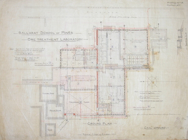
Architectural Drawing, Ballarat School of Mines Ore Treatment Laboratory, 1900, 1900
The Ballarfat School of Mines Mining Plant and Laboratory were formally handed over on 23 May 1902Ground floor plan of ore laboratory drawn on coated cotton cloth, hand colouring Drawing No 3. Initialed "C.B.A. Jan 1900) H [Illegible} 31 1 00smb ore treatment laboratory, mining, ballarat school of mines, department of public works victoria, architecture, plan, laboratory, ore sampling floor, furnace, boiler house engine bed, gaol ground, ballarat gaol ground, laboratory -
 Ringwood and District Historical Society
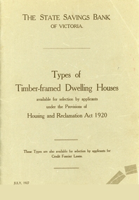
Booklet, Types of Timber Framed Dwelling Houses, Victoria, 1927
Plans show how the modern house has progressed and evolved since 1920.Grey covered booklet of plans for 53 dwelling houses available for selection by applicants under the Housing and Reclamation Act 1920. Published by the State Saving Bank of Victoria -
Port Melbourne Historical & Preservation Society
Plan - Port Melbourne Yacht Club reconstruction, Taylor Howden Pty Ltd, Architects, c. 1990
Clubhouse burned 14 February 1990 and was rebuilt with volunteer labour over many years (opened 1998)Plan of Port Melbourne Yacht Club clubhouse reconstruction 1990 Plan of rebuilt clubhouse; faded almost to illegibilitybuilt environment - recreational facilities, societies clubs unions and other organisations, port melbourne yacht club, pmyc, taylor howden pty ltd -
Port Melbourne Historical & Preservation Society
Plan - Port Melbourne Yacht Club reconstruction, Taylor Howden Pty Ltd, Architects, c. 1990
Clubhouse burned 14 February 1990 and was rebuilt with volunteer labour over many years (opened 1998)Plan of Port Melbourne Yacht Club clubhouse reconstruction 1990 - Preliminary sketch plans; faded almost to illegibilitybuilt environment - recreational facilities, societies clubs unions and other organisations, port melbourne yacht club, pmyc, taylor howden pty ltd -
 Ballarat Tramway Museum
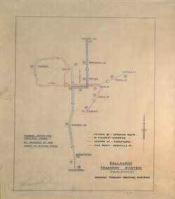
Drawing - Proposed Fares, State Electricity Commission of Victoria (SECV), "Ballaarat Tramway System", 1949
The plan prepared by the SECV shows proposed fares, an increase of 1d on existing fares, and the through routing of tram services. Scale of 40 chains to 1". Alligns with August 1949 Fare By-Law - see item 3111. See also the pdf file "Ballarat Tramway Fares Changes SEC Era", by Warren Doubleday, 03-09-2006.Demonstrates aspects of the way the SEC prepared plans showing tram and ticketing arrangements.Plan titled "Ballaarat Tramway System" - multi-coloured on paper with pencil notations.tramways, ballarat, secv rules, by-laws, tickets, fares -
Tatura Irrigation & Wartime Camps Museum
Map - plan, Engineer for Contruction Railways Dept, Toolamba and Tatura Railway, 18 August 1879
Original plan2 sheets stapled together, white paper. Plan of proposed railway line drawn in ink. Names of property owners transverse shown. Roads show. Existing buildings, dams (tanks), wells and railway culverts.Victorian Railways. signed by Engineer in ink.victorian railways plans -
Whitehorse Historical Society Inc.
Pamphlet, Slater Reserve, c1988
Leaflet with information about Slater Reserve in Blackburn North.Leaflet with information about Slater Reserve in Blackburn North. described as a multi-purpose recreation facility it lists facilities and play equipment. A plan of the reserve is included.Leaflet with information about Slater Reserve in Blackburn North. slater reserve, multi-purpose -
 Whitehorse Historical Society Inc.
Article, Draw up a fence and relax, 1976
Column by journalist Simon Kinch.Column by journalist Simon Kinch, including musings on council requirements for fence plans, road traffic problems in Vermont South and the meanings of the acronym NADRASCAColumn by journalist Simon Kinch.fences, vermont south, nadrasca -
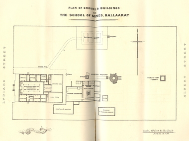 Federation University Historical Collection
Booklet, Charles Boyd, The School of Mines Ballaarat Annual Report, 1882, 1882
The School of Mines Ballaarat Annual Report 24 January 1882, Additional Examination Statute, Certificates Granted by Council, Copy of letter received from the Honble. Francis Ormond MLC, Extracts from Visitors' Book, Fees, Form of Bequest, Life Governors, Museum open to Visitors, Office Bearers, Paper of Particulars, Report of the Curator of the Museum and Library (with plans), Report of the Superintendent of Laboratories, Report of the Lecturer in Telegraphy, Report of the Lecturer in Mechanical Engineering, Statement of Receipts and Expenditure for the year 1881, Subjects and Lecturers, Subjects and Examiners, Subscriptions and Donations from 1 January to 31 December 1881, The Lignite Deposit at Skipton (with Section and Plan)Ballarat School of Mines Annual Report. Pale brown booklet of 64 pages. A plan of the Ballarat School of Mines shows the position of the Botanical Gardens, and the Ballarat School of Mines Museum. Geological Sketch Map of Country in the Neighbourhood of Skipton and Plan showing site of Coal Discovery. Skipton Coal Discovery - Section of Windlass Shaft. .2) is a leatherbound copyballarat school of mines, coal, plan, ballarat school of mines botanical gardens, ballarat school of mines museum, museum, annual report, james oddie, w. p. bechervaise, s. e. friggis, f. j. martell, w. h. nicholls,, e. i. rosenblum, h. r. caselli, thomas mann, theos. williams, f. m. krause, alf. mica smith, walter d. campbell, w. h. shaw, charles kent, andw. berry, robert adam, wm. lant carpenter, henry parkinson, h. b. de la poer wall, w. h. brockenshire, arthur parker, c. davies, simon richards, c. r. blackett, david jones, wilberforce dyke, kr. r. krauel, duncan love, william ralph heaton, edward dowling, octavius vaughan morgan, william denton, e. h. grimwade, james hunter, the honble. francis ormond, ferdinand krause, a.a. buley, j. cosmo newberry, w.c. kernot, john lewis, j.m. bickett, james bickett, fees, annie barnett, annette budden, isabel clinton, john dimsey, agnes pobjoy, charlotte shaw, bernard o'dowd, bernard patrick o'dowd, josiah wasley, ferdinand von mueller, william kernot, john lynch, william henderson, henry richards caselli, w.p. berchervaise, e.i. rosenblum, w.h. nicholls, lignate, samuel figgis, mary drury, w. longley, botanical reserve, botanical gardens, francis ormond, george russell, william foster stawell, w.j. clarke, rivett henry bland, john warrington rogers, j. lonie, s.e. figgis, r.f. hudson, w. robertson, e.l. rosenblum, theophilus williams, andrew berry, henry sutton, h. rosales, state school classes, calcutta international exhibition, examinations, h.b.m ship bounty, certicates, walter charles kernot, william tunbridge, mary skelton, cartherine moran, mary rose usher, margaret ellen brophy, william burbridge, andrea tuxen, elizabeth curnow, francis campigi, james s. morrison, arthur hogue -
 Kew Historical Society Inc
Plan - Subdivision Plan, Bonnie Doon Estate, c.1908
Pru Sanderson, in her groundbreaking ‘City of Kew Urban Conservation Study : Volume 2 - Development History’ (1988), summarised the periods of urban development and subdivisions of land in Kew. The periods that she identified included 1845-1880, 1880-1893, 1893-1921, 1921-1933, 1933-1943, and Post-War Development. These periods were selected as they represented periods of rapid growth or decline in urban development. An obvious starting point for Sanderson’s groupings involved population growth and the associated economic cycles. These cycles also highlighted urban expansion onto land that was predominantly rural, although in other cases it represented the decline and breakup of large estates. A number of the plans in the Kew Historical Society’s collection can also be found in other collections, such as those of the State Library of Victoria and the Boroondara Library Service. A number are however unique to the collection.The Kew Historical Society collection includes almost 100 subdivision plans pertaining to suburbs of the City of Melbourne. Most of these are of Kew, Kew East or Studley Park, although a smaller number are plans of Camberwell, Deepdene, Balwyn and Hawthorn. It is believed that the majority of the plans were gifted to the Society by persons connected with the real estate firm - J. R. Mathers and McMillan, 136 Cotham Road, Kew. The Plans in the collection are rarely in pristine form, being working plans on which the agent would write notes and record lots sold and the prices of these. The subdivision plans are historically significant examples of the growth of urban Melbourne from the beginning of the 20th Century up until the 1980s. A number of the plans are double-sided and often include a photograph on the reverse. A number of the latter are by noted photographers such as J.E. Barnes.The subdivision advertised as the Bonnie Doon Estate in Greensborough was first advertised in 1908. At that stage, the new subdivision included 15 allotments of between one and four acres. By the time the subdivision plan in the Kew Collection was created, only 12 lots of between ¾ and 2½ acres remained. Both the State Library and Kew plans emphasise the distance to the city being 13½ miles, which could be reached by train on weekdays and weekends. Unusually, the plan describes the suitability of lots as locations for ‘Week-end Homes’. Correspondingly, the train line is described as ‘The Holiday Resort for the Northern Suburbs’.bonnie doona estate, subdivision plans - greensborough -
University of Melbourne, Burnley Campus Archives
Plan, Yates Landscape Details - Mr & Mrs Yates, 1993
Plans by John Patrick Pty. Ltd. (1) Tracing paper plan, Yates Landscape Details DRG No P9235-L3. Drawn by M.P. 12.1.93. (2) Tracing paper plan, Irrigation Plan DRG No P9235-L3. Scale 1:100. Drawn by M.P. 20.8.93. (3) Tracing paper plan, Yates Planting and Layout DRG No 9235-L1. Drawn by M.P. 6.1.93.john patrick pty. ltd., hawthorn, yates, landscape design -
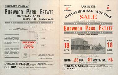 Melbourne Tram Museum
Ephemera - Real estate sale, Duncan & Weller Auctioneers, "Burwood Park Estate" Boundary Road, 1926
Pamphlet advertising the sale of land at the Burwood Park Estate, Boundary Road Burwood, Saturday 4th September. Does not give the year, most likely 1926. Promotes the tram service, nearby shops, the suitability of the soil for gardening and other facilities. Has a photo of possibly W 259 at the terminus. The plan of sub-division shows 18 lots for sale.Demonstrates the style of land sale pamphlet including the availability of tram services to prospective purchasers.Pamphlet - folded - printed in two colours of cream coloured paper with photographs and plans.sale of land, trams, real estate, burwood park, burwood -
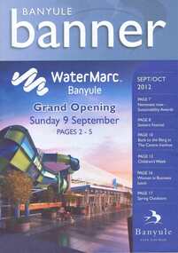 Greensborough Historical Society
Document collection, Banyule City Council, Watermarc, Greensborough, 2004-2012
The development of the Greensborough town centre and in particular the redevelopment of the Greensborough Pool into the Watermarc aquatic centre is documented in this collection of minutes, correspondence, plans, brochures, etc. Contents: Box 1, Correspondence, Project updates, Leaflets, Plans, Newspaper articles. Community Consultative Committee meetings - Agendas and Minutes. Box 2: Greensborough Project Presentation Package 2006; Greensborough principal activity centre plan (executive summary 2005, 2008); Consultation documents 2005; Banyule Banner (2005; 2006); Project update 2005; Newspaper article collection; Advertising leafletsThis collection is significant as it covers the development of the pool precinct from concept plan to completed complex.A collection of various documents relating to the development of the Watermarc pool complex. Includes leaflets, plans, minutes of committee meetings and letters to committee member (in black ring binder).watermarc, greensborough, greensborough pool, swimming pools, rosalie bray, banyule city council -
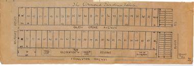 City of Moorabbin Historical Society (Operating the Box Cottage Museum)
Plan - Ormond Garden Estate, Ormond, 1920
At the end of World War One, there was a renewed interest in residential land and a number of estates opened up in the Municipality of Moorabbin. Ormond Garden Estate was auctioned on Saturday 10 April, 1920.Example of the progress of the Municipality of MoorabbinHand drawn plan of subdivisionOrmond Garden Estatenorth road, glen orme avenue, murray road, ormond, auction, real estate -
Port Melbourne Historical & Preservation Society
Plan - Pathworks, Heath Street, Port Melbourne, Borough of Sandridge, 16 Feb 1861
Plan - Pathworks Heath StreetFrederick Wm. Bull Municipal Surveyor Sandridgeengineering - roads streets lanes and footpaths, frederick william bull -
University of Melbourne, Burnley Campus Archives
Plan, Re-organisation of Apple Block, 1956
Plan dated June 1956orchards, fruits, apples -
University of Melbourne, Burnley Campus Archives
Plan, BSL Rear Court 66 Brunswick St Fitzroy, 1980-1990
Tracing paper site plan.fitzroy, planning -
University of Melbourne, Burnley Campus Archives
Plan, V.C.A.H Burnley Location map, c.1991
Plan of the Campus with buildings named.vcah, burnley campus -
University of Melbourne, Burnley Campus Archives
Plan - Planting Design, Vireya Rhododendrons, 2015
vireya rhododendrons, garden plan, plant list -
University of Melbourne, Burnley Campus Archives
Plan (Item), Pavilion, Horticultural Gardens, Burnley
pavilion, burnley gardens, burnley horticultural college -
Kew Historical Society Inc
Plan - Charteris Estate, Ivanhoe [East], 1927
Subdivision plans and real estate flyers/brochures reveal a number of aspects of urban development and history. The Kew Historical Society's collection of these plans, as well as advertisements extracted from magazines, cover key aspects of community development and architectural history of Kew and Kew Eat as well as surrounding suburbs. While most of the plans in the collection were gifted to the Society by the former City of Kew, a number of other plans and advertisements have been donated by individuals, of which this is an example.Original 4-page bifold handout advertising 43 residential lots for sale in the Charteris Estate subdivision in Ivanhoe [now classified as Ivanhoe East]. This brochure was created to sell the third section of the estate which it labels as 'The Most Superb Section'. Streets within the subdivision include: Burke Road North, McArthur Road, Castella Street, and the Government Boulevard. In addition to the overall plan spread across pages 2 and 3, each page includes a number of interesting photographs including: a number of the new Burke Road Bridge, a sports ground, Hoyts Picture Theatre in Ivanhoe, a croquet ground, and Ivanhoe shopping centre [named Motor Cross Junction].charteris estate - east ivanhoe (vic), subdivision plans -- ivanhoe east (vic.), d.c. mcarthur, charterisville -
 Kew Historical Society Inc
Plan - Subdivision Plan, Windella-Darnley Subdivision, Studley Park, 1920s
Subdivision plans are historically important documents used as evidence of the growth of suburbs in Australia. They frequently provide information about when the land was sold on which a built structure was subsequently constructed as well as evidence relating to surveyors and real estate and financial agents. The numerous subdivision plans in the Kew Historical Society's collection represent working documents, ranging from the initial sketches made in planning a subdivision to printed plans on which auctioneers or agents listed the prices for which individual lots were sold. In a number of cases, the reverse of a subdivision plan in the collection includes a photograph of a house that was also for sale by the agent. These photographs provide significant heritage information relating house design and decoration, fencing and household gardens.Version 2 of two subdivision plans (the earlier is 2016.0305.1) for the section of Studley Park Road near the Junction on the south side. Named in the subdivision are the mansions of Darley and Windella (now demolished). Before the subdivision of Darley and Windella, both houses fronted Studley Park Road. Both houses appear to be advertised as lots in the subdivision. Bisecting the subdivision is a street, Antrim Avenue that was never constructed. A street, which was subsequently constructed in this vicinity, was Merrion Place, which now runs between Studley Park Road and Highfield Grove. There are 13 proposed lots in this subdivision in contrast to the earlier plan. This resulted from larger lots being proposed for Studley Park Road.subdivision plans - kew, studley park, windella, darnley, antrim avenue -- kew (vic.), studley park road -- kew (vic.), merrion place -- kew (vic.), merrion grove -- kew (vic.), highbury grove -- kew (vic.) -
 Federation University Historical Collection
Plan - Plans, Ballarat School of Mines Old Chemistry Building Refurbishment Plans
The Old Chemistry Building on the Federation University Australia SMB campus is one of the earliest remaining buildings used at the Ballarat School of Mines.Digital copies of refurbishment plans for University of Ballarat's refurbishment plans for the Old Chemistry Building, Ballarat School of Mines Campus.ballarat school of mines, old chemistry building, refurbishment, smb campus -
Port Melbourne Historical & Preservation Society
Plan - Port Melbourne Yacht Club reconstruction, Taylor Howden Pty Ltd, Architects, c. 1990
Clubhouse burned 14 February 1990 and was rebuilt with volunteer labour over many years (opened 1998)Plan of Port Melbourne Yacht Club clubhouse reconstruction 1990 Plan of clubhouse prior to 1990; faded almost to illegibilitybuilt environment - recreational facilities, societies clubs unions and other organisations, port melbourne yacht club, pmyc -
Port Melbourne Historical & Preservation Society
Plan - Port Melbourne Yacht Club reconstruction, Taylor Howden Pty Ltd, Architects, c. 1990
Clubhouse burned 14 February 1990 and was rebuilt with volunteer labour over many years (opened 1998)Plan of Port Melbourne Yacht Club clubhouse reconstruction 1990 - PMYC site and location plan; faded almost to illegibilitybuilt environment - recreational facilities, societies clubs unions and other organisations, port melbourne yacht club, pmyc, taylor howden pty ltd -
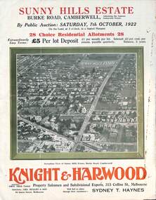 Melbourne Tram Museum
Ephemera - Real estate sale, Knight Harwood, "Sunny Hills Estate" - Burke Road Camberwell, Oct. 1922
Pamphlet advertising the sale of land at the "Sunny Hills Estate" Burke Road Camberwell 7-10-1922. Gives terms of sale, photos showing a nearby shopping centre, recently constructed houses, and plan of the subdivision. Land prices have been written in for each block on the pamphlet. Has a photo featuring Camberwell Junction with a tram, and Burke Road view with trams. Demonstrates the style of land sale pamphlet including the availability of tram services to prospective purchasers.Pamphlet - folded - printed in three colours of cream coloured paper with photographs and plans.has ink notes re sale price and notes.sale of land, trams, real estate, burke road, camberwell, sunny hills estate -
![7 Roomed Brick [villa]; Modern Conveniences](/media/collectors/550653872162f11fb04854aa/items/59ec3da221ea690fdc4ba793/item-media/59ec3ee521ea690fdc4d0c37/item-fit-380x285.jpg) Kew Historical Society Inc
Kew Historical Society IncPhotograph - 7 Roomed Brick [villa]; Modern Conveniences, 1920s
The Kew Historical Society's map collection includes a substantial number of real estate subdivision plans, mainly of Kew but also of surrounding suburbs in Melbourne. Most of the subdivision plans date from the 1920s and 1930s when the districts old homes and local farmland were being split up to accommodate residential growth in the postwar period. These early plans were assembled by a local firm, Jas R Mather & McMillan, which had an office in Cotham Road. Many of the plans, and sometimes photos, were annotated by the agents.Subdivision plans are historically important documents used as evidence for the growth of suburbs in Australia. They frequently provide information about when the land was sold as well as evidence relating to surveyors and real estate and financial agents. The numerous subdivision plans in the Kew Historical Society's collection represent working documents, ranging from the initial sketches made in planning a subdivision to printed plans on which auctioneers or agents listed the prices for which individual lots were sold. In a number of cases, the reverse of a subdivision plan in the collection includes a photograph of a house that was also for sale by the agent. These photographs provide significant heritage information relating house design and decoration, fencing and household gardens.The photograph may also be aesthetically significant depending on the importance of the photographic atelier.A professionally produced photograph for a local real estate agent, probably Jas. R. Mathers, Son & McMillan. The photograph is of a Federation-era bungalow, in Kew. The photo is on the reverse of a subdivision plan for the Normanby Heights Estate, Kew.The mount on which the photograph is placed includes: "Kew. 1 minute to tram. Good Position. / 7 roomed brick. Modern conveniences. / Land 60 x 135. 1100 pounds"real estate photographs, houses - kew, federation architecture -
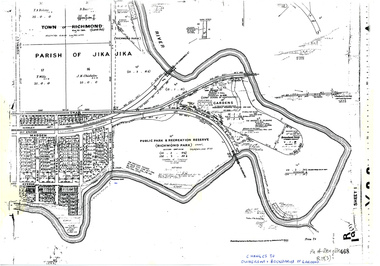 University of Melbourne, Burnley Campus Archives
Plan, Allan & Tuxen et al, Public Park & Recreation Reserve (Richmond Park), 1886-1994
Shows changes in ownership of various parts of Richmond Park and Burnley Gardens by University of Melbourne, Amrad, Melbourne City Link, etc. from gazettal in 1873 to 1996Photocopy of plan of 19.11.1886 with University of Melbourne land acquisition 13.10.1994 hand drawn on it, dates Act revoked and Gazette numbers. Plan of Jika Jika R(19)3. Allan & Tuxen Plan of Melbourne and Suburbspublic parks, recreation reserve, richmond