Showing 31147 items matching "7-5-1937"
-
 Eltham District Historical Society Inc
Photograph - Aerial Photograph, Landata, Eltham; Crown Allotment 15, Section 5, Parish of Nillumbik (Stokes Orchard Estate), Mar. 1987
Centred on present day Diosma Rd, Stokes Pl, Nyora Rd and Eucalyptus Rd Historic Aerial Imagery Source: Landata.vic.gov.au Aerial Photo Details: Project No :1716 Project : WESTERN PORT FORESHORES Run : 15 Frame : 108 Date : 03/1987 Film Type : B/W Camera : RC10 Flying Height : 5600 Scale : 10000 Film Number : 4102 GDA2020 : 37°43'00"S, 145°10'13"E MGA2020 : 338725, 5824036 (55) Melways : 22 D5 (ed. 42)719 (55) Melways : 22 D4 (ed. 42) A History of the Development of Crown Allotment 15, Section 5, Parish of Nillumbik – Stokes Orchard Crown Allotment 15, Section 5, Parish of Nillumbik (CA15) is a square allotment of 158 acres or approximately a quarter of a square mile. It lies just beyond the eastern end of Pitt Street, south of Nyora Road to the northern end of Eucalyptus Road and extends east from Eucalyptus Road to Reynolds Road. The topography of CA15 is generally steep, sloping up to a hill near the centre of the land, the ridgeline passing through the properties along the southern side of Diosma Road. Eucalyptus Road is a straight north-south road with its northern end at the north west corner of CA15. Until the end of the 1970s this road was an un-named Government Road and was largely not open to traffic. With residential development in the 1970s the road was constructed, and the council allocated the name obviously in recognition of the predominant species of the local bushland. CA15 was purchased from the Crown by George D’Arley Boursiquot, a prominent Melbourne printer, on 28th October 1852. On November 23, 1922, former Member for Gippsland and Melbourne Real Estate Agent, Hubert Patrick Keogh purchased the allotment then sold it March 13, 1925, to local farmer, Robert David Taylor, a former Shire of Eltham Councillor (1911-1920) and Shire President (1919). Taylor had extensive land holdings stretching west towards Bible Street and Main Road. The Taylor home was situated at the top of the hill in Bible Street at present day 82 Bible Street. At the time of Taylor’s purchase in 1925, CA15 was subdivided into 48 lots that could be described as small rural properties or large residential lots. A typical lot size was one hectare or 2.5 acres. The subdivision created two roads, Nyora Road, and Diosma Road, each following an irregular alignment between Eucalyptus and Reynolds Roads. However, the lots were not sold off separately nor were the roads constructed. The land effectively remained as one parcel for many further years. Robert David Taylor died November 30, 1934, and probate was granted to his son of the same name, Robert David Taylor of Bible Street, Salesman and William McLelland Vance Taylor of 73 Emmeline Street, Northcote, Clerk, with the transfer of the land into their names on July 8, 1935. Frank Stokes worked as a qualified accountant at Kennons leather factory in Burnley, while living at 1 Thomas Street, Mitcham. He suffered from migraines and wanted to return to working the land (he had previously worked on farms and orchards since coming to Australia from England in 1926, both in WA and Vic.). He first travelled to the district by train in July 1942 to find land with the intention to establish an orchard. By chance he met Arthur Bird of Bird Orchard (bounded by Pitt Street, Eucalyptus Road, and Wattle Grove) and they got talking over their common interest. Arthur put Frank up for the night and pointed out the land, 158 acres- part of the Taylor Estate- £900, Crown Allotment 15, Section 5, Parish of Nillumbik (CA15) somewhat diagonally opposite Bird Orchard. Stokes applied through the Riverina Agency to purchase the land who in turn applied for permission from Canberra to sell as there was a new government regulation introduced during the Second World War banning land sales except for immediate production. Stokes obtained a loan on his Mitcham house of £600 @ 5% and paid £450 deposit with quarterly payments of £15 spread over 5 years. Stokes was assisted and advised by Arthur Bird who farmed the neighbouring orchard. In early 1943 Stokes took possession and would catch the train out to Eltham on Fridays after work and began building a hut on the corner of Nyora Road and the Government Road (Eucalyptus Road) for shelter and to lock up tools. He established an orchard on the central western part of the land through the centre of which ran a natural waterway (part of the present-day linear park) and was able to pay a neighbour (Hawkins) to help with clearing and fencing 25 acres, and with a horse and single furrowed plough, planted approximately 2,500 fruit trees - cherries, peaches, plums, almonds, pears, apricots and lemons as well as a few apples and oranges; a massive task. Aerial photographs from the 1940s through to the 1990s clearly show the orchard with most of the larger CA15 site remaining as natural bushland. A huge problem was hares and rabbits eating all the new buds off the tiny trees. As well as laying poison he painted the trees with a mixture of cow manure and lime, often working by moonlight. Procurement of wire and wire netting was difficult because of the war but after much effort he obtained a permit from the Agricultural Department for supplies in March 1944. In February 1945 Stokes applied for a permit to build a “packing shed” as no house building was allowed. It was to be 33 feet x 21 feet and cost £312. It was constructed mostly from second-hand materials, which were hard to obtain, especially iron for roofing. Stokes finished work at Kennons on October 31, 1945, and in March 1946 he sold the family home at Mitcham for £1,230 plus £170 for furniture. On May 15, 1946, title to the CA15 property was issued to Frank Howard Alfred Stokes, Orchardist and Gladys Ethel Stokes, Married Woman, both of Pitt Street, Eltham. The family of five then moved into the very unfinished “packing shed” at Eltham, which was a struggle to weatherproof. Eventually rooms were divided off and lined with hessian bags and whitewashed. Their income was firewood (cut and sold), selling rockery stones and cut Sweet Bursaria. (It was discovered during the 1940s that Sweet Bursaria contained the sunscreen compound Aesculin. The RAAF utilised this compound from Sweet Bursaria during WW2 for pilots and gunners.) The orchard’s first fruit sale was a half-case of Le Vanq peaches in December 1947 for the price of 8 shillings. In 1956 plans for house were drawn and Glen Iris bricks purchased (1956 Olympic Rings variant). The building of the house commenced in 1957 - 12 feet of original packing shed was removed – and was completed in 1959. Water was connected from newly built pressure storage on the property at the end of 1959 and the electricity connection for the first time at 3pm on April 29, 1960. The house remains to present day (somewhat modified) at 1 Nyora Road, home to Nyora Studio Gallery. On occasions, spare remnants of the 1956 bricks have been known to be unearthed in gardens on the estate as they were utilised by Frank Stokes to fill in rabbit holes. On May 26, 1950, a parcel of land was compulsorily acquired by the Melbourne and Metropolitan Board of Works on the hilltop to establish an easement for a high-level service reservoir to augment Eltham’s water supply. The project also included pipe tracks for the necessary water mains. The reservoir has now been superseded by higher level water tanks east of Reynolds Road and its former site is now a public reserve. On November 27, 1964, the State Electricity Commission served notice to compulsorily acquire a further parcel through the eastern part of the land for a major electricity transmission line that augmented supply from the La Trobe Valley to Melbourne. The easement was registered February 11, 1966. The easement was widened July 18, 1969 for a second transmission line to be constructed. In 1971 Melbourne Metropolitan Planning Scheme amendments adopted Nyora Road as the boundary between a residential zone to the north and a rural zone to the south. This determined the future development of the land. In the mid-1970s the Shire of Eltham divided the orchard into numerous rate-able parcel lots, the 48 lots having been established in 1925 and the subsequent rates assessment proved unsustainable for Stokes. He commenced selling lots outside the boundary of the orchard, north of Diosma and South of Nyora. However shortly later the land between Nyora and Diosma Roads and west of the electricity easement was sold and subdivided into residential lots, a housing development by Macquarie Builders and marketed as the Stokes Orchard Estate. New streets were created, and most were named after trees, although one, Stokes Place, commemorates the former owners. The development was undertaken in two stages; Stage 1 (1975) encompassing Scarlet Ash Court, Ironbark Close and Peppermint Grove bounded by Nyora and Eucalyptus roads and Stage 2 (1978) encompassing Stokes Place, Orchard Way, The Crest and The Lookout bound by Nyora and Diosma roads. The developer, Macquarie Builders went bankrupt shortly after the release of Stage 2 leaving many purchasers to fend for themselves and arrange for their own independent builders. There were also difficulties with sewerage for the land immediately south of Diosma Road and so the conventional residential lots were abandoned in favour of larger lots. The development of Orchard Way, The Crest and The Lookout did not proceed as planned and the proposed lots were incorporated into five-acre parcels instead. These included a low-density group housing development by the Graves family and the award winning Choong House (1983) with Gordon Ford developed garden immediately next door situated on the ridge of the hill nestled amongst the original bush, Eucalypt trees and Sweet Bursaria. In 1994, Nillumbik Shire Council applied Significant Environment and Significant Landscape overlays upon the properties on the south side of Diosma Road to ensure protection of this natural bush garden environment. With the arrival of the sewer along Diosma Road in the 1990s, most of these five-acre parcels have since been subdivided multiple times. The Choong house presently sits on a 2.7-acre property, which in 2022 Nillumbik Council nominated for Cultural Significance Heritage protection and is considered potentially significant at State level. The Stokes family were also associated with the Eltham Christian Church. In the 1970s this church had met in temporary premises in Eltham. Lots of the original 1925 subdivision remained south of Nyora Road and a number of these lots were utilized for the Eltham Christian School, which was established by the Eltham Christian Church in 1981. The school operated on this site until 2000. The premises are now used by The Vine Baptist Church. By the mid-1980s the whole of CA15 had been developed for residential and school purposes, except for the sections north of Diosma Road and between the transmission lines and Reynolds Road. Sewerage issues had been resolved for the section north of Diosma Road and in 1987 it was in the process of being subdivided into residential lots. The development coincided with the discovery of colonies of the rare and endangered Eltham Copper Butterfly on the site. This resulted in a community and political campaign to save the butterfly habitat. With the co-operation of the land developer the subdivision was altered to create two bushland reserves in the critical butterfly habitat areas. In the late 1980s the State Government was investigating options for establishing a metropolitan ring road link between Diamond Creek and Ringwood. The chosen route was adjacent to Reynolds Road and so this created a freeze on development of CA15 between Reynolds Road and the electricity easement. The ring road proposal was eventually abandoned, and this part of the land was subdivided into low density residential lots. Diosma Road has been discontinued at the electricity easement and the eastern part incorporated into View Mount Court with access from Reynolds Road. The whole of CA15 has now been developed for residential or associated purposes, ranging from conventional density to quite low density south of Nyora Road. Some remnants of the orchard remain, a few cherry trees on the Graves property and a lone apple tree in Stokes Place. The butterfly reserves comprise significant areas of remnant bushland. Linear reserves through the estate link with central Eltham via the Woodridge linear reserve and with Research along the electricity easement. CA15 as it exists today has a complicated history of rural use, Government acquisition, urban development, and community action. References: • “Stokes Orchard, an incomplete history”; Russell Yeoman with Doug Orford • Correspondence, Beryl Bradbury (nee Stokes) • Aerial Photographs, 1931-1991, Landata (landata.vic.gov.au) • Certificate of Title, Vol. 4930 Fol. 985900 • Plan Number LP 10859 aerial photo, diosma road, eltham copper butterfly, eucalyptus road, ironbark close, nyora road, peppermint grove, peter & elizabeth pidgeon collection, power transmission lines, reynolds road, scarlet ash court, stokes orchard estate, stokes place, woodridge estate, frank stokes -
 Eltham District Historical Society Inc
Photograph - Aerial Photograph, Landata, Eltham; Crown Allotment 15, Section 5, Parish of Nillumbik (Stokes Orchard Estate), Sep. 1991
Centred on present day Diosma Rd, Stokes Pl, Nyora Rd and Eucalyptus Rd Historic Aerial Imagery Source: Landata.vic.gov.au Aerial Photo Details: Project No :2072 Project : MELBOURNE PROJECT Run : 13 Frame : 119 Date : 09/1991 Film Type : COL Camera : RC10 Flying Height : 8300 Scale : 15000 Film Number : 4419 GDA2020 : 37°43'07"S, 145°09'35"E MGA2020 : 337812, 5823811 (55) Melways : 22 B6 (ed. 42) A History of the Development of Crown Allotment 15, Section 5, Parish of Nillumbik – Stokes Orchard Crown Allotment 15, Section 5, Parish of Nillumbik (CA15) is a square allotment of 158 acres or approximately a quarter of a square mile. It lies just beyond the eastern end of Pitt Street, south of Nyora Road to the northern end of Eucalyptus Road and extends east from Eucalyptus Road to Reynolds Road. The topography of CA15 is generally steep, sloping up to a hill near the centre of the land, the ridgeline passing through the properties along the southern side of Diosma Road. Eucalyptus Road is a straight north-south road with its northern end at the north west corner of CA15. Until the end of the 1970s this road was an un-named Government Road and was largely not open to traffic. With residential development in the 1970s the road was constructed, and the council allocated the name obviously in recognition of the predominant species of the local bushland. CA15 was purchased from the Crown by George D’Arley Boursiquot, a prominent Melbourne printer, on 28th October 1852. On November 23, 1922, former Member for Gippsland and Melbourne Real Estate Agent, Hubert Patrick Keogh purchased the allotment then sold it March 13, 1925, to local farmer, Robert David Taylor, a former Shire of Eltham Councillor (1911-1920) and Shire President (1919). Taylor had extensive land holdings stretching west towards Bible Street and Main Road. The Taylor home was situated at the top of the hill in Bible Street at present day 82 Bible Street. At the time of Taylor’s purchase in 1925, CA15 was subdivided into 48 lots that could be described as small rural properties or large residential lots. A typical lot size was one hectare or 2.5 acres. The subdivision created two roads, Nyora Road, and Diosma Road, each following an irregular alignment between Eucalyptus and Reynolds Roads. However, the lots were not sold off separately nor were the roads constructed. The land effectively remained as one parcel for many further years. Robert David Taylor died November 30, 1934, and probate was granted to his son of the same name, Robert David Taylor of Bible Street, Salesman and William McLelland Vance Taylor of 73 Emmeline Street, Northcote, Clerk, with the transfer of the land into their names on July 8, 1935. Frank Stokes worked as a qualified accountant at Kennons leather factory in Burnley, while living at 1 Thomas Street, Mitcham. He suffered from migraines and wanted to return to working the land (he had previously worked on farms and orchards since coming to Australia from England in 1926, both in WA and Vic.). He first travelled to the district by train in July 1942 to find land with the intention to establish an orchard. By chance he met Arthur Bird of Bird Orchard (bounded by Pitt Street, Eucalyptus Road, and Wattle Grove) and they got talking over their common interest. Arthur put Frank up for the night and pointed out the land, 158 acres- part of the Taylor Estate- £900, Crown Allotment 15, Section 5, Parish of Nillumbik (CA15) somewhat diagonally opposite Bird Orchard. Stokes applied through the Riverina Agency to purchase the land who in turn applied for permission from Canberra to sell as there was a new government regulation introduced during the Second World War banning land sales except for immediate production. Stokes obtained a loan on his Mitcham house of £600 @ 5% and paid £450 deposit with quarterly payments of £15 spread over 5 years. Stokes was assisted and advised by Arthur Bird who farmed the neighbouring orchard. In early 1943 Stokes took possession and would catch the train out to Eltham on Fridays after work and began building a hut on the corner of Nyora Road and the Government Road (Eucalyptus Road) for shelter and to lock up tools. He established an orchard on the central western part of the land through the centre of which ran a natural waterway (part of the present-day linear park) and was able to pay a neighbour (Hawkins) to help with clearing and fencing 25 acres, and with a horse and single furrowed plough, planted approximately 2,500 fruit trees - cherries, peaches, plums, almonds, pears, apricots and lemons as well as a few apples and oranges; a massive task. Aerial photographs from the 1940s through to the 1990s clearly show the orchard with most of the larger CA15 site remaining as natural bushland. A huge problem was hares and rabbits eating all the new buds off the tiny trees. As well as laying poison he painted the trees with a mixture of cow manure and lime, often working by moonlight. Procurement of wire and wire netting was difficult because of the war but after much effort he obtained a permit from the Agricultural Department for supplies in March 1944. In February 1945 Stokes applied for a permit to build a “packing shed” as no house building was allowed. It was to be 33 feet x 21 feet and cost £312. It was constructed mostly from second-hand materials, which were hard to obtain, especially iron for roofing. Stokes finished work at Kennons on October 31, 1945, and in March 1946 he sold the family home at Mitcham for £1,230 plus £170 for furniture. On May 15, 1946, title to the CA15 property was issued to Frank Howard Alfred Stokes, Orchardist and Gladys Ethel Stokes, Married Woman, both of Pitt Street, Eltham. The family of five then moved into the very unfinished “packing shed” at Eltham, which was a struggle to weatherproof. Eventually rooms were divided off and lined with hessian bags and whitewashed. Their income was firewood (cut and sold), selling rockery stones and cut Sweet Bursaria. (It was discovered during the 1940s that Sweet Bursaria contained the sunscreen compound Aesculin. The RAAF utilised this compound from Sweet Bursaria during WW2 for pilots and gunners.) The orchard’s first fruit sale was a half-case of Le Vanq peaches in December 1947 for the price of 8 shillings. In 1956 plans for house were drawn and Glen Iris bricks purchased (1956 Olympic Rings variant). The building of the house commenced in 1957 - 12 feet of original packing shed was removed – and was completed in 1959. Water was connected from newly built pressure storage on the property at the end of 1959 and the electricity connection for the first time at 3pm on April 29, 1960. The house remains to present day (somewhat modified) at 1 Nyora Road, home to Nyora Studio Gallery. On occasions, spare remnants of the 1956 bricks have been known to be unearthed in gardens on the estate as they were utilised by Frank Stokes to fill in rabbit holes. On May 26, 1950, a parcel of land was compulsorily acquired by the Melbourne and Metropolitan Board of Works on the hilltop to establish an easement for a high-level service reservoir to augment Eltham’s water supply. The project also included pipe tracks for the necessary water mains. The reservoir has now been superseded by higher level water tanks east of Reynolds Road and its former site is now a public reserve. On November 27, 1964, the State Electricity Commission served notice to compulsorily acquire a further parcel through the eastern part of the land for a major electricity transmission line that augmented supply from the La Trobe Valley to Melbourne. The easement was registered February 11, 1966. The easement was widened July 18, 1969 for a second transmission line to be constructed. In 1971 Melbourne Metropolitan Planning Scheme amendments adopted Nyora Road as the boundary between a residential zone to the north and a rural zone to the south. This determined the future development of the land. In the mid-1970s the Shire of Eltham divided the orchard into numerous rate-able parcel lots, the 48 lots having been established in 1925 and the subsequent rates assessment proved unsustainable for Stokes. He commenced selling lots outside the boundary of the orchard, north of Diosma and South of Nyora. However shortly later the land between Nyora and Diosma Roads and west of the electricity easement was sold and subdivided into residential lots, a housing development by Macquarie Builders and marketed as the Stokes Orchard Estate. New streets were created, and most were named after trees, although one, Stokes Place, commemorates the former owners. The development was undertaken in two stages; Stage 1 (1975) encompassing Scarlet Ash Court, Ironbark Close and Peppermint Grove bounded by Nyora and Eucalyptus roads and Stage 2 (1978) encompassing Stokes Place, Orchard Way, The Crest and The Lookout bound by Nyora and Diosma roads. The developer, Macquarie Builders went bankrupt shortly after the release of Stage 2 leaving many purchasers to fend for themselves and arrange for their own independent builders. There were also difficulties with sewerage for the land immediately south of Diosma Road and so the conventional residential lots were abandoned in favour of larger lots. The development of Orchard Way, The Crest and The Lookout did not proceed as planned and the proposed lots were incorporated into five-acre parcels instead. These included a low-density group housing development by the Graves family and the award winning Choong House (1983) with Gordon Ford developed garden immediately next door situated on the ridge of the hill nestled amongst the original bush, Eucalypt trees and Sweet Bursaria. In 1994, Nillumbik Shire Council applied Significant Environment and Significant Landscape overlays upon the properties on the south side of Diosma Road to ensure protection of this natural bush garden environment. With the arrival of the sewer along Diosma Road in the 1990s, most of these five-acre parcels have since been subdivided multiple times. The Choong house presently sits on a 2.7-acre property, which in 2022 Nillumbik Council nominated for Cultural Significance Heritage protection and is considered potentially significant at State level. The Stokes family were also associated with the Eltham Christian Church. In the 1970s this church had met in temporary premises in Eltham. Lots of the original 1925 subdivision remained south of Nyora Road and a number of these lots were utilized for the Eltham Christian School, which was established by the Eltham Christian Church in 1981. The school operated on this site until 2000. The premises are now used by The Vine Baptist Church. By the mid-1980s the whole of CA15 had been developed for residential and school purposes, except for the sections north of Diosma Road and between the transmission lines and Reynolds Road. Sewerage issues had been resolved for the section north of Diosma Road and in 1987 it was in the process of being subdivided into residential lots. The development coincided with the discovery of colonies of the rare and endangered Eltham Copper Butterfly on the site. This resulted in a community and political campaign to save the butterfly habitat. With the co-operation of the land developer the subdivision was altered to create two bushland reserves in the critical butterfly habitat areas. In the late 1980s the State Government was investigating options for establishing a metropolitan ring road link between Diamond Creek and Ringwood. The chosen route was adjacent to Reynolds Road and so this created a freeze on development of CA15 between Reynolds Road and the electricity easement. The ring road proposal was eventually abandoned, and this part of the land was subdivided into low density residential lots. Diosma Road has been discontinued at the electricity easement and the eastern part incorporated into View Mount Court with access from Reynolds Road. The whole of CA15 has now been developed for residential or associated purposes, ranging from conventional density to quite low density south of Nyora Road. Some remnants of the orchard remain, a few cherry trees on the Graves property and a lone apple tree in Stokes Place. The butterfly reserves comprise significant areas of remnant bushland. Linear reserves through the estate link with central Eltham via the Woodridge linear reserve and with Research along the electricity easement. CA15 as it exists today has a complicated history of rural use, Government acquisition, urban development, and community action. References: • “Stokes Orchard, an incomplete history”; Russell Yeoman with Doug Orford • Correspondence, Beryl Bradbury (nee Stokes) • Aerial Photographs, 1931-1991, Landata (landata.vic.gov.au) • Certificate of Title, Vol. 4930 Fol. 985900 • Plan Number LP 10859 aerial photo, diosma road, eltham copper butterfly, eucalyptus road, ironbark close, nyora road, peppermint grove, peter & elizabeth pidgeon collection, power transmission lines, reynolds road, scarlet ash court, stokes orchard estate, stokes place, woodridge estate, frank stokes -
 Glenelg Shire Council Cultural Collection
Photograph - Photograph - Portland Library, Victoria, May-97
Photographs of Portland Library - late 1990s to early 2000s, showing activities at the library and construction of additions to the building.Coloured photo. Portland Library, group of primary school students with teacher, backs to camera, seated on low forms or floor, being entertained / lectured by a woman in a black suit, long hair, standing in front of the group.Front: '97 5 7' -
Glenelg Shire Council Cultural Collection
Photograph, 07/05/1997
Coloured photo. Same subject as 9462, 63, but woman is standing at the side of the room talking to a studentFront: '97 5 7' -
Glenelg Shire Council Cultural Collection
Photograph - Photograph - Portland Library, 07/05/1997
Coloured photo. Portland Library, a woman is sitting down, reading from a book.Front: '97 5 7'council services, portland library, book, reading -
Glenelg Shire Council Cultural Collection
Photograph - Photograph - aerial view of Portland, c. 1954
Black and white aerial photograph of coastline around Portland. Black border, scale all sides, 5 rows of 3 't' at regular intervals. Ocean at right, land on left.Front: '820 - 7' -- handwritten, white, lower border 'RUN 5' 'PORTLAND', printed, white, lower borderaerial photography, central portland, portland harbour, south west coastline -
 Ringwood and District Historical Society
Administrative record - Minute Book, Norman Bros, Committee of the Ringwood Co-operative Cool Stores Society Ltd minute book for committee meetings from the 81st meeting on 7-March-1922 to 200th meeting on 6-Feb-1934, 1920s
Used by the committee of the Ringwood Co-operative Cool Stores Society Ltd. Started at the 81st meeting and ended with the 200th meeting on 6-Feb-1934.Brown watermarked covered book with suede spine and suede corners. 'Minute Book' is printed on red leather on spine. There are 286 pages all used. -
 Ringwood and District Historical Society
Administrative record - Rate Books, Borough of Ringwood Valuation & Rate Cards for 1944-49 (Assessments 3254-7 & 636), March 2012
Originally stored at Ringwood Council offices, then taken to PROV.Only source of ratepayers in the Borough of RingwoodDigital imagesBedford Road, Ringwood. For Osmond Wickham, Frances Howe, Jefferey & Roma Forbes-Ewan & Jefferey & Roma Forbes-Ewan (Colman Estate). -
 Warrnambool and District Historical Society Inc.
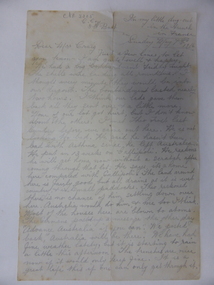
Letter, McDowall - Sunday May 7 1916, 1916
This letter was written during World War One from France in 1916 by Private George McDowall to a friend Mrs Maggie Craig. Private George Francis Ernest McDowall was a farmer from Nirranda who enlisted in August 1915. He landed in Egypt in1916 and was transferred to the 8th Battalion. He was killed in action at Pozieres on 25 July 1916 and was buried in France. This letter is an original one and is an important relic from World War One – from a soldier from the Warrnambool area who did not return. The letter is headed ‘From my little dug-out in the trench in France’ and he wrote: ‘It is a great life this if one can only get through it’. He did not survive the war and was killed only two and a half months after this letter was written. This is a letter written from France in 1916 during World War One. It is handwritten in pencil on buff-coloured paper. The paper has been folded and it is a little torn at the top. The page has some staining from age and handling. world war one, private george mcdowall, warrnambool history, world war 1 soldier's letter -
 Warrnambool and District Historical Society Inc.
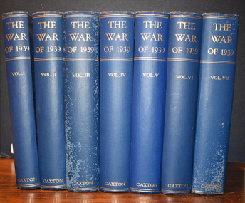
Book, Vernon Bartlett and W Gordon Williams, The War of 1939 ( 7 volumes), 1940
These seven volumes contain of the history of the Second World War from the English point of view. The inscription shows that the books belonged to James Low. Scottish born James Low came to Australia and worked in the Swintons' shoe store in Warrnambool. He served in World War One and in the 1930s he opened his own shoe business. He died in 1976. These books are of antiquarian interest and have local provenance.These books have blue hard covers with an embossed image of Caxton on the front. There is gold printing on the spines. The pages contain printed text, black and white photographs and maps.J.S.Lowworld war two., james low of warrnambool -
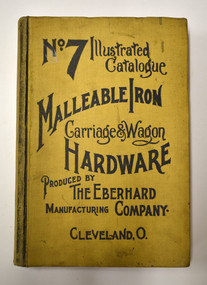 Warrnambool and District Historical Society Inc.
Book - Illustrated Catalogue of Malleable Iron Hardware, The Eberhard Manufacturing Company, No. 7 Illustrated Catalogue Malleable Iron Hardware, 1908
Catalogue from American company of malleable hardware itemsThis is a book of 732 pages. It has a yellow cloth cover with black printing and pages edged in red. The contents contain an index and pages of black and white sketches and text.non-fictionCatalogue from American company of malleable hardware itemscarriage and wagon hardware, eberhard manufacturing company -
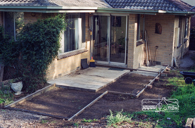 Eltham District Historical Society Inc
Negative - Photograph, Harry Gilham, 7 Leonard Crescent, Eltham, Sep 2009
Repairs and reconstruction to front concrete patio, part of the Bridgeland Park Estate. Representative of the period homes of the time and how usage patterns change.Roll of 35mm colour negative film, 6 stripsKodak GC 400-9bridgeland park estate, eltham, houses, leonard crescent -
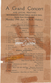 Eltham District Historical Society Inc
Document - Programme, A Grand Concert and Social Meeting, Montmorency Presbyterian Church Hall, Rattray Road, Greensborough, Monday, 29th Jan., A.N.A. Holiday at 7 p.m, 1951
Held in 1951concert performance, cr. price, madame richardson, miss cameron, miss clarke, miss davidson, miss dove, miss dyke, miss ivy smith, miss sims, miss taylor, miss vera fyfe, montmorency presbyterian church hall, mr andrews, mr derbyshire, mr gilsenan, mr miller, mr norman hardman, mr sharpe, mr staines, mrs howson, program, rattray road, rev. prof. adam -
 Eltham District Historical Society Inc
Ephemera (Item) - Poster, Eltham Shire Council, Eltham Festival; Faces and places, November 7, 8, 9, 10, 1991
Promotional poster for the 1991 Eltham Festival featuring the theme of Faces and Places1991, eltham festival, eltham services clubs, eltham shire council, poster, shire of eltham archives -
 Eltham District Historical Society Inc
Newspaper - Newspaper article, Diamond Valley News, Jenny Macklin is ALP's choice for Jagajaga seat by Natalie Town, Diamond Valley News, December 7, p7, 1994
council amalgamation, shire of eltham, shire of montsalvat, shire of nillumbik, 1994, city of banyule, city of heidelberg, local government board, montsalvat, shire of diamond valley, jagajaga, jenny macklin -
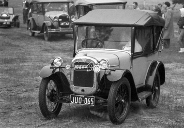 Eltham District Historical Society Inc
Photograph, George Coop, Austin 7, Lake Goldsmith Steam Rally, Beaufort, Vic, c.1971
Digital TIFF file Scan of 35mm Ilford HP4 black and white negative transparency, c.1971george coop collection, lake goldsmith steam rally, steam rally, beaufort (vic.), steam traction engine, austin 7, automobile, beach buggy, car, chevrolet series 490 -
 Eltham District Historical Society Inc
Newspaper clipping, Rotary Eltham Town Festival, What's on, Diamond Valley News, 7 November 2018, 2018
NewsclippingNewsprint Newsclippingalistair knox park, central park, eltham festival, panther place, rotary club of eltham, rotary eltham town festival -
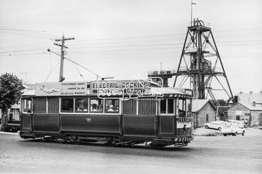 Eltham District Historical Society Inc
Photograph, Bendigo Tramways No. 7 en route to Golden Square passes the Central Deborah Gold Mining Co, High Street (Midland Highway) and Violet Street, Bendigo, January 1972, Jan 1972
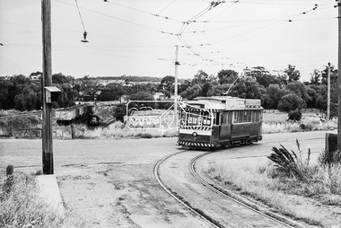
Looking east from Midland Highway at intersection of Violet StreetDigital TIFF file Scan of 35mm Ilford FP3 black and white negative transparencybendigo, bendigo tramways no. 7, central deborah gold mining co. n.l., eaglehawk, george coop collection, golden square, high street, midland highway, tram, violet street -
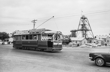 Eltham District Historical Society Inc
Photograph, Bendigo Tramways No. 7 en route to Golden Square passes the Central Deborah Gold Mining Co, High Street (Midland Highway) and Violet Street, Bendigo, January 1972, Jan 1972
Looking east from Midland Highway at intersection of Violet StreetDigital TIFF file Scan of 35mm Ilford FP3 black and white negative transparencybendigo, bendigo tramways no. 7, central deborah gold mining co. n.l., eaglehawk, george coop collection, golden square, high street, midland highway, tram, violet street -
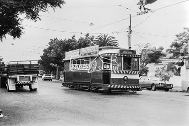 Eltham District Historical Society Inc
Photograph, Bendigo Tramways No. 7 en route to Golden Square, January 1972, Jan 1972
Most likely High Street, Golden SquareDigital TIFF file Scan of 35mm Ilford FP3 black and white negative transparencybendigo, bendigo tramways no. 7, eaglehawk, george coop collection, golden square, high street, tram -
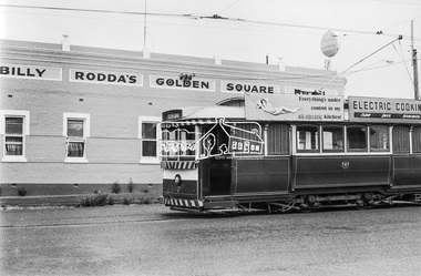 Eltham District Historical Society Inc
Photograph, Bendigo Tramways No. 7 en route to Golden Square on High Street near the intersection of Maple Street, Golden Square, January 1972, Jan 1972
Billy Rodda's Golden Square Hotel now known as the Golden Square HotelDigital TIFF file Scan of 35mm Ilford FP3 black and white negative transparencybendigo, bendigo tramways no. 7, billy rodda's golden square hotel, eaglehawk, george coop collection, golden square, high street, maple street, tram -
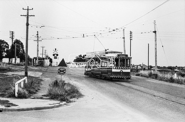
 Eltham District Historical Society Inc
Photograph, Bendigo Tramways No. 7 about to arrive at its terminus in North Bendigo near the intersection of Thunder Street and Moray Crescent, January 1972, Jan 1972
The tram line proceeds up to the left just pass Moray Crescent where it terminated alongside the railway line in North Bendigo in 1972Digital TIFF file Scan of 35mm Ilford FP3 black and white negative transparencybendigo, bendigo tramways no. 7, george coop collection, moray crescent, north bendigo, railway crossing, railway line,thunder street, tram -
 Eltham District Historical Society Inc
Photograph, Bendigo Tramways No. 7 departs from Thunder Street in North Bendigo en route to Golden Square, Bendigo, January 1972, Jan 1972
The tram line proceeds up to the left just pass Moray Crescent where it terminated alongside the railway line in North Bendigo in 1972Digital TIFF file Scan of 35mm Ilford FP3 black and white negative transparencybendigo, bendigo tramways no. 7, george coop collection, moray crescent, north bendigo, railway crossing, railway line, thunder street, tram -
 Eltham District Historical Society Inc
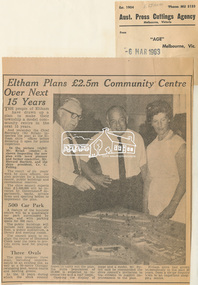
Newspaper Clipping, Eltham Plans £2.5m Community Centre Over Next 15 Years, The Age, 6 March 1963 page 7, 1963
Eltham Plans £2.5m Community Centre Over Next 15 Years THE people of Eltham have drawn up a plan to make their township a model community centre in the next 15 years. And yesterday the Chief Secretary (Mr Rylah) inspected the plan at the Eltham shire offices before declaring it open for public inspection In the picture (right) Mr. Rylah (centre) is shown inspecting the new plan with town planner and former councillor, Mr. Howard Bartlett, and the shire president, Cr. C. Pelling. The result of six years' work by shire officers, the plan provides for a business centre, public buildings and recreational reserves. The shire council expects that £2,500,000 will be invested by Government departments, banks, private firms and sporting bodies to implement the plan. 500 Car Park A feature of the business centre will be a quadrangle car park surrounded by shops, and with parking space for 500 cars. The public buildings will include new municipal offices, a public auditorium, a library and meeting rooms. The council plans to realign the course of Diamond Creek near the town to provide extra land for playing fields. Three Ovals The plan proposes three ovals, including improvements to an existing one, as well as a 50-metre Olympic swimming pool, tennis courts and bowling greens. In the 15 years which the shire council hopes to carry out the plan, the shire population of 18,000 is expected to increase two and a half times. Opening the display of maps and a model, Mr. Rylah said he commended the shire council's invitation to the citizens to suggest improvements to the plan. Eltham shire had grown tremendously in the past 20 years, from a sleepy country town to an important shopping centre. Digital file only of copy provided on loanauditorim, bowlong green, charis pelling, eltham community centre, rylah, howard bartlett, car park, library, forward plan -
 Eltham District Historical Society Inc
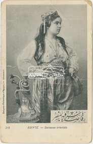
Postcard, Postcard to Lily Howard from Robert Harris from No. 3 Aust. Aux. Hospital, Heliopolis, Egypt, 7 February (1916), 1916
Digital file only - scanned by EDHS from item on loan aif, egypt, first world war, heliopolis, letters, lew howard collection, lily howard, robert harris, ww1 -
 Eltham District Historical Society Inc
Postcard, Postcard to Lily Howard from Pte Patrick Francis Plunkett, France, 7 August 1917, 1917
Digital file only - scanned by EDHS from item on loan aif, first world war, france, letters, lew howard collection, lily howard, patrick francis plunkett, ww1 -
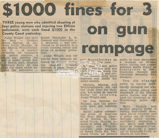 Eltham District Historical Society Inc
Newspaper clipping, $1000 fine for 3 on gun rampage, Diamond Valley News, 7 May 1975, 1975
Five Diamond Creek youths, from 18 to 19 years arrested following a shootup of the Eltham Police Station at 3:30am on Sunday, March 16, 1975. Senior Constable Lew Howard was shot through the window during the incident.Digital file only - scanned by EDHS from item on loaneltham, eltham court, eltham police station, judge wright, lew howard, lew howard collection, lewis howard, police station, pryor street, shooting, victoria police -
 Eltham District Historical Society Inc
Photograph, George Coop, Single Motor Carriage (Red Rattler) Tait train just about to arrive at Hurstbridge Railway Station, 7-8 February 1981, 1981
Digital TIFF file Scan of 35mm Ilford FP4 black and white transparencyhurstbridge line, hurstbridge railway station, red rattler, red rattler single carriage, single motor carriage, tait train -
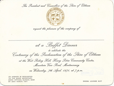 Eltham District Historical Society Inc
Card, Invitation to Buffet Dinner to celebrate the Centenary of the Proclamation of the Shire of Eltham at the West Riding Hall, Henry Petrie Community Centre, Mountain View Road, Montmorency, 7 April 1971, 1971
Originally donated in a photo album prepared by Doug and Gwen Orford of Historical Society trips.Invitation cardinvitation, activities, buffet dinner, henry petrie community centre, shire of eltham centenary -
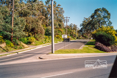 Eltham District Historical Society Inc
Photograph, Rattray Road access from Sherbourne Road, Montmorency opposite the 7-Eleven and Eltham Fort Knox, c.July 1991, 1991
Opposite the Shire Council Depot (formerly Fayrefield Hat Factory and now Eltham Fort Knox). Comment from David Taylor (via Facebook 2/4/2018): My family home was at 216 Rattray and I remember Powell's old garage on the right where the servo is now decades before the road was excavated. They had an aviary (very exciting for a very young child) and hand pumped kerosene.Colour photographmontmorency, streets, rattray road, sherbourne road