Showing 2090 items
matching bendigo maps
-
 Bendigo Historical Society Inc.
Map - JACK FLYNN COLLECTION: EDDINGTON, 1.12.1925
... Inc. History House 11 Mackenzie Street Bendigo goldfields MAP ...Map: Parish of Eddington, Counties of Gladstone and Talbot. Parish plan.Dept of Lands and Survey Melbourne by W.J. Butson 1.12.25map, talbot, parish plan, eddington, counties of talbot, gladstone -
 Bendigo Historical Society Inc.
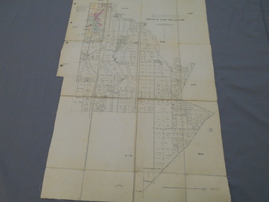
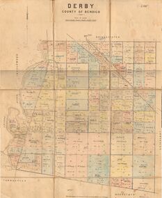
Map - JACK FLYNN COLLECTION: DERBY, 12/05/1892
... Map: Derby, County of Bendigo. Parish plan.... Inc. History House 11 Mackenzie Street Bendigo goldfields MAP ...Map: Derby, County of Bendigo. Parish plan.Department of Lands and Survey Melbourne by T.F.McGauran, 12.5.92map, bendigo, parish plan, derby -
 Bendigo Historical Society Inc.
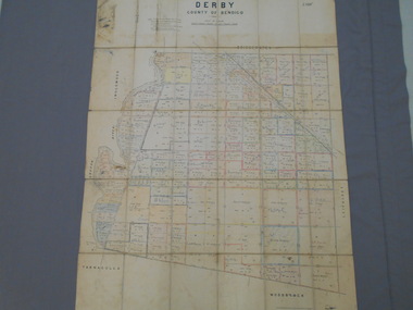
Map - JACK FLYNN COLLECTION: DERBY, 1/09/1909
... Map: Derby, County of Bendigo. Parish plan.... Inc. History House 11 Mackenzie Street Bendigo goldfields MAP ...Map: Derby, County of Bendigo. Parish plan.Dept of Lands and Survey, Melbourne by T.E.McGauran 1.9.09map, bendigo, parish plan, derby -
 Bendigo Historical Society Inc.
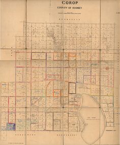
Map - JACK FLYNN COLLECTION: COROP, 8/08/1929
... Inc. History House 11 Mackenzie Street Bendigo goldfields MAP ...Map: Corop, County of Rodney. Parish plan.By Authority H. J. Green, Govt. Printer, Melb. Dept of Lands and Survey Melbourne by Price 8.8.29map, rodney, parish plan, corop, county of rodney -
 Bendigo Historical Society Inc.
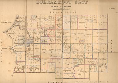
Map - JACK FLYNN COLLECTION: BURRUMBOOT EAST, 21/12/1027
... Inc. History House 11 Mackenzie Street Bendigo goldfields MAP ...Map: Burrumboot East, County of Rodney. Parish plan.Photo Lithographed at the Department of Lands and Survey, Melbourne by W.J.Butson. 21.12.27map, rodney, parish plan, burrumboot east -
 Bendigo Historical Society Inc.
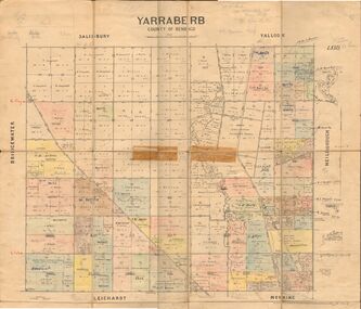
Map - JACK FLYNN COLLECTION: YARRABERB, 2/03/1931
... Map: Yarraberb, County of Bendigo. Parish plan.... Inc. History House 11 Mackenzie Street Bendigo goldfields MAP ...Map: Yarraberb, County of Bendigo. Parish plan.By Authority H.J. Green Govt., Printer. Photo Lithographed at the Department of lands and Survey Melbourne, 2.3.31.map, bendigo, parish plan, yarraberb -
 Bendigo Historical Society Inc.
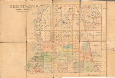
Map - JACK FLYNN COLLECTION: BRIDGEWATER, 6/10/1927
... Map: Bridgewater , County of Bendigo. Parish plan.... Inc. History House 11 Mackenzie Street Bendigo goldfields MAP ...Map: Bridgewater , County of Bendigo. Parish plan.Photo Lithographed at the Department of Lands and Survey, Melbourne by W.J. Butson.map, bendigo, parish plan, bridgewater -
 Bendigo Historical Society Inc.
Map - JACK FLYNN COLLECTION: ECHUCA NORTH, November 1953
... Inc. History House 11 Mackenzie Street Bendigo goldfields MAP ...Map: Echuca North, County of Rodney. Parish plan.By Authority: W.M. Houston, Government Printer. Drawn and Reproduced at the Dept., of Lands and Survey Melbourne, Victoria. November 1953map, rodney, parish plan, echuca north rodney -
 Bendigo Historical Society Inc.
Map - JACK FLYNN COLLECTION: BURNEWANG, 17/09/1918
... Inc. History House 11 Mackenzie Street Bendigo goldfields MAP ...Map: Parish of Burnewang, County of Rodney. Parish plan.By Authority, H. J. Green, Acting Government Printer Melbourne. Photo Lithographed at the Department of Lands and Survey, Melbourne by W. J. Butson.map, rodney, parish plan, burnewang, rodney -
 Bendigo Historical Society Inc.
Map - JACK FLYNN COLLECTION: BONN, 16/07/1919
... Inc. History House 11 Mackenzie Street Bendigo goldfields MAP ...Map: Parish of Bonn, County of Rodney. Parish plan.By Authority A. J. Mullett. Government Printer, Melbourne. Photo Lithographed at the Department of Lands and Survey. Melbourne by W. J. Butson.map, rodney, parish plan, bonn, rodney -
 Bendigo Historical Society Inc.
Map - JACK FLYNN COLLECTION: VILLAGE OF BETLEY, 30/06/1874
... Inc. History House 11 Mackenzie Street Bendigo goldfields MAP ...Map: Village of Betley, on the Bet Bet Creek, Parish of Dunolly. Parish plan.Photo Lithographed at the Department of Lands and Survey Melbourne by J. Noone 30.6.74map, gladstone, village, betley, bet bet creek, dunolly -
 Bendigo Historical Society Inc.
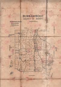
Map - JACK FLYNN COLLECTION: BURRUMBOOT, August 1951
... Inc. History House 11 Mackenzie Street Bendigo goldfields MAP ...Map: Parish of Burrumboot, County of Rodney. Parish plan.By Authority J.J. Gourley, Government Printer Melbourne. Drawn and Reproduced at the Dept of Lands and Survey, Melbourne, Victoria. August 1951map, rodney, parish plan, burrumboot, rodney -
 Bendigo Historical Society Inc.
Map - JACK FLYNN COLLECTION: BEALIBA, 15/09/1931
... Inc. History House 11 Mackenzie Street Bendigo goldfields MAP ...Map: Parish of Bealiba, County of Gladstone. Parish plan.By Authority H.J. Green, Government Printer. Photo Lithographed at the Government of Lands and Survey Melbourne. 15.9.31map, gladstone, parish plan, bealiba, gladstone -
 Bendigo Historical Society Inc.
Map - JACK FLYNN COLLECTION: BAMAWM, 19/08/1924
... Inc. History House 11 Mackenzie Street Bendigo goldfields MAP ...Map: Parish of Bamawm, County of Bendigo. Parish plan.Photo Lithographed at the Department of Lands and Survey, Melbourne by W.J. Butson. 19.8.24map, bendigo, parish plan, bamawm -
 Bendigo Historical Society Inc.
Map - JACK FLYNN COLLECTION: BET BET SHEET 2, 17/09/1931
... Inc. History House 11 Mackenzie Street Bendigo goldfields MAP ...Map: Parish of Bet Bet Sheet 2. Parish plan.Photo Lithographed at the Lands and Survey Melbourne. 17.9.31map, gladstone, parish plan, bet bet -
 Bendigo Historical Society Inc.
Map - JACK FLYNN COLLECTION: ARCHDALE, 15/01/1936
... Inc. History House 11 Mackenzie Street Bendigo goldfields MAP ...Map: Parish of Archdale, County of Gladstone. Parish plan. The Allotments have been coloured in with pencil.By Authority H.J. Green, Government Printer Melbourne. Drawn and Reproduced at the Dept, of Lands and Survey, Melbourne, Victoria. 15/01/36map, gladstone, parish plan, archdale , gladstone -
 Bendigo Historical Society Inc.
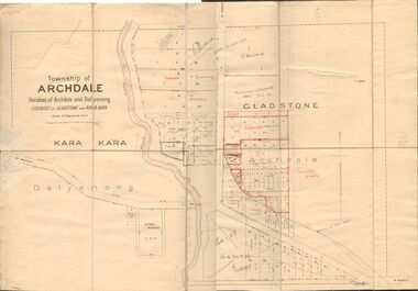
Map - JACK FLYNN COLLECTION: TOWNSHIP OF ARCHDALE, /08/1904
... Inc. History House 11 Mackenzie Street Bendigo goldfields MAP ...Map: Township of Archdale, Parishes of Archdale and Dalyenong, Counties of Gladstone and Kara Kara. Scale 4 Chains to 1 Inch. Has attached letters relating to land transfers between the Estate of Kate Sanderson and Barry Frederick Mortlock also between Matilda Jane Sanderson and A. O. Proctor.J. K. Spark Narrister & Solicitor, Formerly Mitchell, Monotti & Sparkmap, gladstone, township, archdale, dalyenong, gladstone, kara kara -
 Bendigo Historical Society Inc.
Map - JACK FLYNN COLLECTION: COHUNA, 1963
... Inc. History House 11 Mackenzie Street Bendigo goldfields MAP ...Map: Photocopy of parish plan showing Cohuna and a portion of the Gunbower Creek.By Authority. A.C. Brooks Government Printer, Melbourne. Drawn and Reproduced at the Department of Lands and Survey, Melbourne.1963.map, gunbower, parish plan, cohuna , gunbower creek -
 Bendigo Historical Society Inc.
Map - JACK FLYNN COLLECTION: BET BET, 18/08/1931
... Inc. History House 11 Mackenzie Street Bendigo goldfields MAP ...Map: Parish of Bet Bet, Counties of Gladstone and Talbot . Parish plan.By Authority H.J. Green Govt, Printer. Photo Lithographed at the Department of Lands and Survey, Melbourne. 18.8.31map, gladstone, parish plan, bet bet, counties of gladstone and talbot. -
 Bendigo Historical Society Inc.
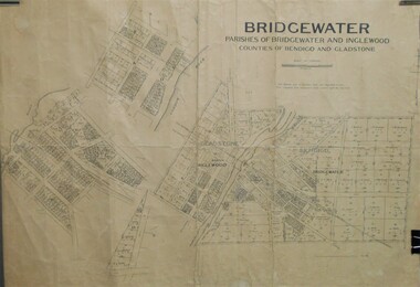
Map - JACK FLYNN COLLECTION: BRIDGEWATER, 10/09/1931
... Inc. History House 11 Mackenzie Street Bendigo goldfields MAP ...Map: Bridgewater, Parishes of Bridgewater and Inglewood, Counties of Bendigo and Gladstone. Parish plan.map, bendigo, parish plan, bridgewater inglewood -
 Bendigo Historical Society Inc.
Map - JACK FLYNN COLLECTION: KARA KARA, 1932
... Inc. History House 11 Mackenzie Street Bendigo goldfields MAP ...Map: County of Kara Kara, map sheet showing the whole of the County of Kara Kara and all of the Parishes within. Scale 2 miles to 1 inch.By Authority: W.M. Houston, Government Printer Melbourne. Department of Lands and Survey, Melbourne, 1958map, kara kara, county, kara kara -
 Bendigo Historical Society Inc.
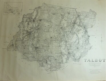
Map - JACK FLYNN COLLECTION: TALBOT, 1937
... Inc. History House 11 Mackenzie Street Bendigo goldfields MAP ...Map: County of Talbot, map sheet showing the whole of the County of Talbot and all of the Parishes within. Scale 2 Miles to 1 inch.By Authority: A.C. Brooks, Government Printer, Melbourne. Department of Lands and Survey Melbourne. 1959map, talbot, county, talbot -
 Bendigo Historical Society Inc.
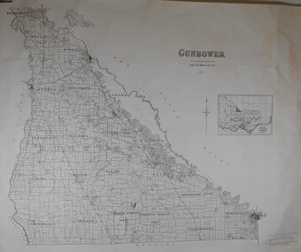
Map - JACK FLYNN COLLECTION: GUNBOWER, 1935
... Inc. History House 11 Mackenzie Street Bendigo goldfields MAP ...Map: County of Gunbower, map sheet showing the whole of the County of Gunbower and all of the Parishes within.map, gunbower, county, gunbower -
 Bendigo Historical Society Inc.
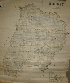
Map - JACK FLYNN COLLECTION: RODNEY, Revised in 1935
... Inc. History House 11 Mackenzie Street Bendigo goldfields MAP ...Map: County of Rodney, map sheet showing the whole of the County of Rodney and all of the Parishes within.Drawn at the Department of Lands and Survey, Melbourne. Revised to 1935map, rodney, parish plan, rodney -
 Bendigo Historical Society Inc.
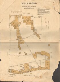
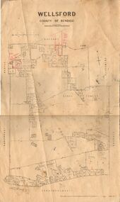
Map - JACK FLYNN COLLECTION: WELLSFORD, 15/12/1941
... Inc. History House 11 Mackenzie Street Bendigo goldfields MAP ...Map: Parish of Wellsford, County of Bendigo. Parish plan. 2 copies of the same plan.map, bendigo, parish plan, wellsford -
 Bendigo Historical Society Inc.
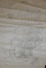
Map - JACK FLYNN COLLECTION: HUNTLY, August 1954
... Inc. History House 11 Mackenzie Street Bendigo goldfields MAP ...Map: Parish of Huntly, County of Bendigo. Parish plan.By Authority W.M. Houston, Government Printer. Drawn and Reproduced at the Dept, of Lands and Survey, Melbourne, Victoria. August 1954.map, bendigo, parish plan, huntly -
 Bendigo Historical Society Inc.
Map - JACK FLYNN COLLECTION: WELLSFORD, 2/11/1914
... Inc. History House 11 Mackenzie Street Bendigo goldfields MAP ...Map: Parish of Wellsford, County of Bendigo. Parish plan.Photo-Lithographed at the Department of Lands and Survey Melbourne By H.J. Butson. 2-.11.14map, bendigo, parish plan, wellsford -
 Bendigo Historical Society Inc.
Map - JACK FLYNN COLLECTION: GOORNONG, August 1953
... Inc. History House 11 Mackenzie Street Bendigo goldfields MAP ...Map: Township of Goornong, Parish of Goornong, County of Bendigo. Parish plan.By Authority W.M. Houston. Government Printer. Drawn and Reproduced at the Dept., of Lands and Survey, Melbourne, Victoria. August 1953map, bendigo, township, goornong -
 Bendigo Historical Society Inc.
Map - JACK FLYNN COLLECTION: HUNTLY, 12.03.1932
... Inc. History House 11 Mackenzie Street Bendigo goldfields MAP ...Map: Township of Huntly, Parish of Huntly , County of Bendigo. Parish plan. Western and South Riding Division on Main St. (Main Northern Highway) - written in ink below name of map.BY Authority H.J. Green. Photo-Lithographed at the Dept., of Lands and Survey, Melbourne. 12.3.32map, bendigo, township, huntly -
 Bendigo Historical Society Inc.
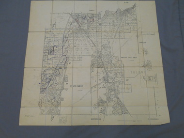
Map - JACK FLYNN COLLECTION: COUNTY OF GLADSTONE, 1934
... Inc. History House 11 Mackenzie Street Bendigo goldfields MAP ...Map: County of Gladstone, map sheet showing the whole of the County and the Parishes within. Scale 2 Miles to 1 inch.Engraved at the Department of Lands and Survey Melbourne. 1958. By Authority of W.M. Houston, Government Printermap, gladstone, parish plan, gladstone