Showing 19894 items
matching east-malvern
-
 Kew Historical Society Inc
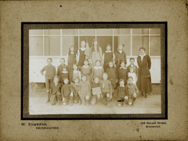
Photograph - Kew East Primary School, 1919
State School No. 3161 was originally situated between High Street (then Bulleen Road) and Kilby Road adjacent to Burke Road and was officially opened on 25th April 1892 with Mr Roland Gray as its Headmaster. With more people moving into the district, the School was moved in 1905 to Strathalbyn Street. (This site was to became the Kew East Bowling Club, and is now a Kindergarten.) 1929 saw the erection of the brick Infant School adjacent to the main building. In subsequent years many other buildings were added, including a weatherboard ‘Rural’ school, a brick library, an administration block, several portables, and a Community Music Centre and shelter sheds, culminating in the opening in March 2011 of the Commonwealth funded new Music/Sports Complex. At one time it was called Kew East Central School and included years 7 & 8. When Kew High School started, the high school students were accommodated there whilst their buildings were being completed.Original print positive, mounted on board of a co-educational class of students at Kew East 'Country School'. The Age newspaper on 6 March 1906 included in News of the Day that: "At a meeting of the Executive Council yesterday it was decided to proclaim the following State schools as training schools under the provisions of the Teachers' Act: Brunswick 1213; Queensberry-street, Carlton 2365; Kew East 3161; and Queensberry-street, North Melbourne 307. These schools have been specially selected and staffed in order that teachers in training and junior teachers may study the methods of the best teachers in special kinds of work. The infant class is the special feature at Brunswick, while Kew East will be a model of the methods of a country school. The schools at Queensberry-street, North Carlton and North Melbourne, are to be more especially connected with the training college."Obverse: Written on chalk slate - "Kew East / 3161 / Country School /19??"kew east primary school, margery canham, margery nickell, elizabeth angel, kew east state school, kew east country school, erik nickell -
 Kew Historical Society Inc
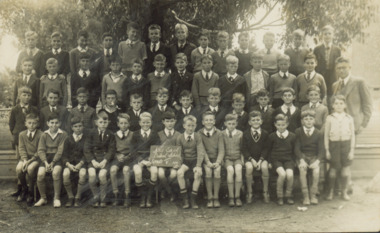
Photograph - Kew East Central School, c.1911
State School No. 3161 was originally situated between High Street (then Bulleen Road) and Kilby Road adjacent to Burke Road and was officially opened on 25th April 1892 with Mr Roland Gray as its Headmaster. With more people moving into the district, the School was moved in 1905 to Strathalbyn Street. (This site was to became the Kew East Bowling Club, and is now a Kindergarten.) 1929 saw the erection of the brick Infant School adjacent to the main building. In subsequent years many other buildings were added, including a weatherboard ‘Rural’ school, a brick library, an administration block, several portables, and a Community Music Centre and shelter sheds, culminating in the opening in March 2011 of the Commonwealth funded new Music/Sports Complex. At one time it was called Kew East Central School and included years 7 & 8. When Kew High School started, the high school students were accommodated there whilst their buildings were being completed.Original print positive of a class of boys at Kew East Central School. The Age newspaper on 6 March 1906 included in News of the Day that: "At a meeting of the Executive Council yesterday it was decided to proclaim the following State schools as training schools under the provisions of the Teachers' Act: Brunswick 1213; Queensberry-street, Carlton 2365; Kew East 3161; and Queensberry-street, North Melbourne 307. These schools have been specially selected and staffed in order that teachers in training and junior teachers may study the methods of the best teachers in special kinds of work. The infant class is the special feature at Brunswick, while Kew East will be a model of the methods of a country school. The schools at Queensberry-street, North Carlton and North Melbourne, are to be more especially connected with the training college."Obverse: on chalkboard - "East Kew Central School, Grade 5. 1911 [sic]". kew east primary school, elizabeth angel, kew east state school, kew east central school -
 Robin Boyd Foundation
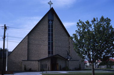
Slide, Robin Boyd, 1965
Colour slide in a mount. Church of the Holy Eucharist, 1241 Dandenong Road, East Malvern, 1962. (Architects: Alan Robertson and Associates.)Made in Australia / 36 / JAN 65Mmelbourne, slide -
 Ringwood and District Historical Society
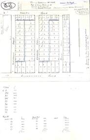
Plan, Plan of Subdivision No.11498 with handwritten costing notations - East Ringwood Central Estate c.1948
Two handwritten pages showing layout of Subdivision no 11498 with surveyor notations including property sizes and road construction cost calculations. Drainage easement 6 feet wide shaded blue.Plan of Subdivision No. 11498, Part of Crown Allotment 27, Parish of Ringwood, County of Mornington, (Certificate of Title Vol 5120 Fol 1023945). Owner Mr Vogel. Subdivision includes Knaith Road, Northwood Street, Langley Street, Bondi Street, and Government Road (later Alexandra Road), Ringwood East. G. Parsons & Sons, Licensed Surveyors, 389 Flinders Lane (Melbourne). -
 Whitehorse Historical Society Inc.
Clothing - Windcheater, c.1985
See Ref. NA4362Child's maroon school windcheater. Round neck with long sleeves. School motif of white rising sun with 'Blackburn East' Primary School on a scroll on left hand side.'Blackburn East'costume, children's uniform -
 Ringwood and District Historical Society
Administrative record, Ringwood East State School No 4180-Pupil Registers July 1924 - 30 August 1993 Transcriptions, 2021
Pdf of Transcriptions of the Ringwood East SS Pupil Registers covering registrations in the period Jan 1951 - Mar 1982 The original Registers are held at Public Records Victoria (PROV). Scanning of these was commissioned by Ringwood and District Historical Society (RDHS) and undertaken by Mark Grealy, Archival Access in 2013. (https://www.archivalaccessvictoria.com/). The resigters were transcribed in 2021-2022 by Sue Breese, Archivist at Ringwood and District Historical Society. Images of each of the register books are held in VC items 7510 and 7524. The particular image number of a page relating to an entry can be found from the attached searchable transcription pdf. -
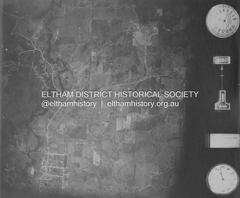 Eltham District Historical Society Inc
Photograph - Aerial Photograph, Landata, Eltham and Eltham East, Nov. 1931
Centred over present-day Beard Street bewteen Park Road and Main Road, Eltham East Historic Aerial Imagery Source: Landata.vic.gov.au Aerial Photo Details: Project No :1931 Project : MALDON PRISON Run : 20 Frame : 3135 Date : 11/1931 Film Type : B/W Camera : F8 Flying Height : 11000 Scale : 18860 Film Number : 60 GDA2020 : 37°42'16"S, 145°09'41"E MGA2020 : 337912, 5825386 (55) Melways : 22 B2 (ed. 42)aerial photo, eltham, neil webster collection, beard street, eltham east, main road, park road -
 Eltham District Historical Society Inc
Photograph, Looking east along Main Road, Lower Plenty approaching the top of the hill and Grand Boulevard, July 1969, 1969
The Eltham Apex Club conducted a Community Service Project (1965-1968) to raise funds for a new Ambulance Station to service the community. A site bounded by the intersection of Main Road, Grand Boulevard and Looker Road at Montmorency was purchased in 1969. In 1970, Eltham Shire Council undertook roadworks to construct Apex Way in preparation for the new station as well as duplicate Main Road, Lower Plenty, east of Grand Boulevard including the new Lower Plenty Bridge, which had been opened in November 1966, bordering with the City of Heidelberg.35mm colour positive transparency blue Agfacolour Service plastic mountambulance station, apex-diamond valley ambulance station, eltham ambulance station, eltham apex club, lower plenty, main road, montmorency -
Tatura Irrigation & Wartime Camps Museum
Photographs, Tatura East School Netball Premiers 1983, 1983
Framed photos presented to Museum with other material on the closure of the school, c.2002. Tatura East Primary School Premiership Netball Teams 1983.|Photo 1: "C" Grade, Annabelle Simson (Coach)|T. Attwood; J. Campbell; E. Starrit; S. Brian.|H. Campbell; T. Starrit; M. Wheelhouse; J. Vigliaturo.|Photo 2: "D" Grade: Kaye Pyke (Coach); S. Haberfied; L. Gilmore; E. Pogue; K. Simson; S. Mason; P. Williams; A. Wheelhouse; M. Starrit.Silver framed colour photos. -
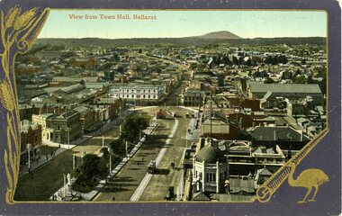
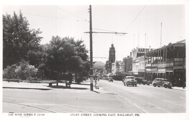 Ballarat Tramway Museum
Postcard, Rose Stereograph Co, "Sturt Street, looking east, Ballarat Vic", late 1940s
The photo shows the view of the south side of Sturt Street from Dawson St looking east. The cross-over at this location can be seen in the bottom left-hand corner of the photograph. In the view are the Town Hall, Harry Davies store, the ABC Cafe and a sign for the Block Arcade. On the rear, Wal Jack in a note to Ken Magor has written: "From Dawson St. Xover on left connects "up" track, shunt only. 4-wheel tram at Dovetoin St. Date taken? about 1947-49".Yields information about Ballarat during the late 1940sPostcard black and white, divided back, with a handwritten note on rear.See image 2 for details of the handwritten note by Wal Jack on the rear. tramways, trams, sturt st, rose postcards, dawson st -
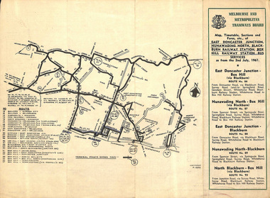 Melbourne Tram Museum
Ephemera - Timetable, Melbourne & Metropolitan Tramways Board (MMTB), East Doncaster Junction, Nunawading North, Jul, 1961
Timetables for specific routes, day of week giving information on tram times at specific time points, route map, sections and fares and organisation address - 616 Little Collins St. Melbourne. 2nd July 1961 1 - East Doncaster Junction, Nunawading North, Blackburn Railway Station, Box Hill Railway Station- Mitcham - Ringwood. 2 - Doncaster Junctioin - Melbourne - route 81 with many supplementary routes - July 1961 3 - Bulleen - City - Garden City routes 15 and 16 - July 1961Demonstrates and early MMTB timetable for bus routes which included extensive details of services.Set of 3 MMTB Bus timetable, folded sheets with maps.Bus routes underlined in blue inktrams, tramways, timetables, tickets, bus services, fares, mmtb, doncaster, ringwood, mitcham, bulleen, garden city, route 15, route 16, route 81 -
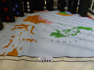 National Vietnam Veterans Museum (NVVM)
Map, Flawed Theory, 2009
Large PVC 1965 political map of South East Asia with nine large dominoes attached'Asia South East Political 1965'domino theory, 3rar, jones, geoffrey r -
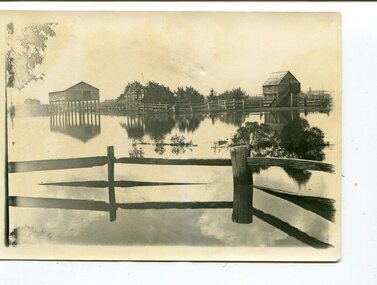 Orbost & District Historical Society
black and white photographs, 1890s
Peter Cameron, came to Orbost in 1885, at the age of 69, having sold his farm at Geelong. Peter bought the property ―Glen Avon from a Mr Street. The home was situated at the bottom of the paddock, near the corner of Morley and Livingstone streets. The farm stretched from Tennyson Street to the end of Snaggers Lane and along the river frontage to “Carinya” Cameron Home. In the Gippsland Times on Wednesday. 2 Jul 1890 on Page 3 is an article titled "THE SNOWY RIVER CALAMITY" which describes an ".unexpectedly sudden rush of water down the flats..... the terrified people commenced to remove their stock from the land and the work of saving property was continued all day ............ many head of cattle were washed away.......The river road, for its entire length, is obliterated, and the approaches to the bridge at Watt's Gulch are gone, with the enormous volume of flood water," These photographs are pictorial records of a significant event in the history of Orbost. There are few personal records of the very early floods.Three black / white photographs of wooden buildings with flood water in foreground. There are post and rail fences. 3193.2 has been taken from a distance.on back -" "Glenavon east of Lagoon 1897 Feb"floods-orbost-1890s glenavon-orbost -
 Ringwood and District Historical Society
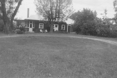
Photograph, Landys home (formerly Patersons). Byways estate area (East Ringwood). 5 Views. (c1968)
SS0261 is the covering letter from Beth Little, dated 31/3/1969, which states: "Please fined enclosed the photographs I took of Landy's 80 yr. old home which was moved just before last Christmas to another site on their estate...it was built by some people by the name of Patterson and originally included the Byways Estate and other land which extended up to about Lillis Crt. The land known as Byways Estate was sold off to a Mr Best by a later owner so far as I can find out.." Written on back of photographs: SS0261a:From about where the feed shed was. SS0261b:Looking up driveway towards the east. Landys home (formerly Patersons). Byways estate area (East Ringwood) SS0261c:Eastern side of house (officially the front). SS0261d:Stable and feed shed now demolished. Wooden tank on right-hand side. SS0261e:Southern side. Well to left of far end of house wall -
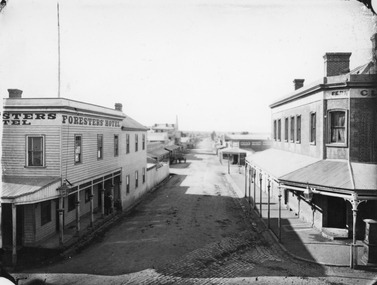 Stawell Historical Society Inc
Photograph, Main Street & Patrick Streets corner looking East down Patrick Street with the Foresters Hotel on left corner 1878
First floor view from corner of Main & Patrick Streets looking East down Patrick Street. Weatherboard Foresters Hotel in Main Street on left corner. Businesses visible down Patrick street, Foresters Hotel, J.H. Wallis Royal Exchange Hotel on Big Hillside of Street. With St Patrick's church tower visible in distance. Melbourne Cash Store Wines and Spirits on corner of Patrick and Sloane Street near centre of photo. Ferns Hotel / Times office on right of photo, corner of Patrick and Main Street. Post Box on Corner at right of photo. 1878First floor view from Main Street Patrick Street intersection looking down Patrick Street. Foresters Hotel on left. Victorian Views. C. Herbert, Photo. Stawell 1878stawell businesses streetscape -
 Ballarat Heritage Services
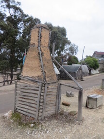
Photograph - Colour, Chimney at Sovereign Hill, 2015, 03/03/2015
Colour photograph of a chumneyat Sovereign Hill, Ballarat East.sovereign hill, architecture, chimney -
 Ballarat Heritage Services
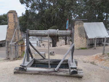
Photograph - Colour, Windlass at Sovereign Hill, 2015, 03/03/2015
Colour photograph of a windlass at Sovereign Hill, Ballarat East.sovereign hill, windlass, mining -
 Federation University Historical Collection
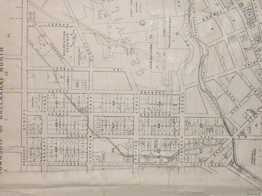
Plan, City of Ballarat (Part) (Ballaarat East), 08/05/1928
Crown Cadastral Plan showing Governement Roads, Crown Parcels, Dimensions, Crown grantees, dated of grants, etc in Ballarat East. The plan shows features such as Bakery Hill, Canadian Station, recreation reserves, timber reserves, Yarrowee Creek, Black Hill Reserve, Eureka Reserve and Garden, Orphan Asylum, Rifle Butts Reserve, Ballarat Woollen Mill, Ballarat Observatory, Sovereign Hill Recreation Reserve, Specimen Vale, Market Reserve, Cemetery WGS 84 Centroid 37 degrees 33' 55" S 143 degrees 52' 38" E E.W. Extent; 5 km N-S Extent; 4 kmmap, plan, ballarat east, ballarat woollen mill, ballarat railway line, ballarat railway station, eureka reserve, eureka cemetery, ballarat orphanage, russell square, bakery hill -
 Kew Historical Society Inc
Plan - Subdivision Plan, Jas R Mathers Son & McMillan, East Kew Tramway Estate, 1915
Pru Sanderson, in her groundbreaking ‘City of Kew Urban Conservation Study : Volume 2 - Development History’ (1988), summarised the periods of urban development and subdivisions of land in Kew. The periods that she identified included 1845-1880, 1880-1893, 1893-1921, 1921-1933, 1933-1943, and Post-War Development. These periods were selected as they represented periods of rapid growth or decline in urban development. An obvious starting point for Sanderson’s groupings involved population growth and the associated economic cycles. These cycles also highlighted urban expansion onto land that was predominantly rural, although in other cases it represented the decline and breakup of large estates. A number of the plans in the Kew Historical Society’s collection can also be found in other collections, such as those of the State Library of Victoria and the Boroondara Library Service. A number are however unique to the collection.The Kew Historical Society collection includes almost 100 subdivision plans pertaining to suburbs of the City of Melbourne. Most of these are of Kew, Kew East or Studley Park, although a smaller number are plans of Camberwell, Deepdene, Balwyn and Hawthorn. It is believed that the majority of the plans were gifted to the Society by persons connected with the real estate firm - J. R. Mathers and McMillan, 136 Cotham Road, Kew. The Plans in the collection are rarely in pristine form, being working plans on which the agent would write notes and record lots sold and the prices of these. The subdivision plans are historically significant examples of the growth of urban Melbourne from the beginning of the 20th Century up until the 1980s. A number of the plans are double-sided and often include a photograph on the reverse. A number of the latter are by noted photographers such as J.E. Barnes.The East Kew Tramway Estate was a subdivision of two separate parcels of land between Adeney Avenue and Normanby Road. The larger section included 54 lots facing Adeney Avenue, Argyle Road, and Campbell, Hunter and Wishart Streets. [Hunter and Wishart Streets were created as part of the subdivision.] A further 17 allotments faced Normanby Road, Hubert and Campbell Streets. [The name of Hubert Street was later to be changed to Cecil Street.] The promotion of the sale referred to the advantages of living between two tram routes, in High Street and Cotham Road. On the plan, quaintly drawn trams mark these routes. Also on the plan is the route of part of the Outer Circle [Railway] Line.east kew tramway estate, subdivision plans - east kew -
 Melbourne Tram Museum
Photograph - Digital Image, Kevin O'Reilly, St Kilda looking east over St Kilda Junction, late 1925
Image from CD (Compact Diskette for use in computers) - see Reg Item 135. Image titled "St Kilda" on CD, of looking east over St Kilda Junction from. Has St Kilda tramway Jtn (St Kilda Road, Fitzroy St, Barkly St, Brighton Road, Wellington St and Punt Road in the photograph, and the "Junction Oval". Mid to late 1925 as workmen are converting the cable track in Fitzroy St and Wellington St looks or appears converted with a crossover installed near the junction. Two cable car sets visible in St Kilda Road, on in Brighton Road and a bus? Also a bus? in Fitzroy St.trams, tramways, st kilda junction, st kilda railway station, fitzroy st, brighton rd, cable trams -
 Melbourne Tram Museum
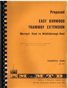
Document - Report, Melbourne & Metropolitan Tramways Board (MMTB), "Proposed East Burwood Tramway Extension - Warragul Road to Middleborough Road - Feasibility Study, Sep. 1974
Report - 68 pages, photocopied onto light cartridge paper with brown covers both sides, overlain with clear plastic covers and black comb bound. Titled "Proposed East Burwood Tramway Extension - Warragul Road to Middleborough Road - Feasibility Study June 1974", looks at the purpose of the extension, possible patronage, construction details, costs, existing services and impact on these, proposed services, operating costs, revenue and social benefit - cost analysis. Has many tables, diagrams including fold out map. Showed that the benefit outweighed the costs of the project. Prepared by the MMTB June 1974 - report on front page notes it is Amendment A, September 1974.Stamped "Australian Electric Traction Association Public Transport Committee" on both cover and inside front page.trams, tramways, burwood, east burwood, feasibility study, new tramway, mmtb, middleborough rd -
 Ringwood and District Historical Society
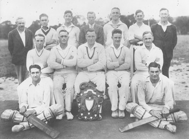
Photograph, East Ringwood Cricket Club, 1931
Written on back of photograph, "East Ringwood Cricket Club, 1931. B. Row: 1. J. Rimmer, 2. G. Cassidy, 3. J.M. Hann, 4. R. Stoney, 5. Tim Blood, 6. J. Hodgkins, 7. W. Kerr. Centre: 1. Les Perry, 2. Bert Dellas, 3. Roger Webber, 4. Bert Rimmer, 5. W. Errington. Front: Roy Cassidy, Doug Cassidy". -
 Ringwood and District Historical Society
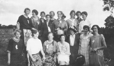
Photograph, Organising committee helpers at the opening of East Ringwood Railway Station, 27 June,1925. List of those named shows back row from left to right - Bertha Hodges, Mrs. Lord, ?, Mrs. Hann, Mrs. Watson, ?, Mrs. Maggs, ?. 2nd row - Linda Pump, Vera Watson, Alma Dickson, Marj Blood, ?, Mrs. Howship, Poss Howship
Written on back of photograph, 'June 27th 1925. To Mother from Vera.' and 'Committee ladies that helped at opening of East Ringwood Railway Station.' There is a copy of photo on paper where those in picture are named. They are back row from left to right - 'Bertha Hodges, Mrs. Lord, ?, Mrs. Hann, Mrs. Watson, ?, Mrs. Maggs, ?' Second row, 'Linda Pump, Vera Watson, Alma Dickson, Marj Blood, ?, Mrs. Howship, Poss Howship'. -
 Federation University Historical Collection
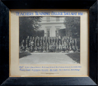
Photograph, Teachers' Training College Ballarat, 1930
The Ballarat Teachers' College was established after the Victorian State Government and the State Education Department decided to establish two provincial teachers' colleges, at Ballarat and Bendigo. On 04 May 1926 W.H. Ellwood (Principal), Miss A. Bouchier, and Mr A.B. Jones, welcomed the first enrolment of 61 students to undertake the one year course. In 1927 the College moved to the former Ballarat East Town Hall in Barkly Street, which was remodelled for their use. It closed in December 1931 due to the Great Depression. In 1946 Ballarat Teachers' College reopened and relocated to the Dana Street State School. The building used by the Teachers' College was the original bluestone building facing Doveton Street South. It was originally planned to open as a women's college, for whom the residence at 130 Victoria Street was purchased, but the decision was made to admit resident men from Ballarat. Mr T.W. Turner was appointed as Principal in 1951 and directed the introduction of a two year course for the Trained Primary Teachers' Certificate. The former one year course was terminated at the end of 1951. In 1958 the College was relocated to a custom built facility at Gillies Street, in close proximity to the Ballarat Botanical Gardens. Numbers increased with the introduction of the Trained Infant Teachers' Certificate course under the guidance of Mary Egan. With the introduction of a three year Diploma Course in 1968 accommodation became cramped. The introduction of the Diploma of Teaching (Primary) led to the Trained Infant Teachers' Certificate being discontinued in 1969, and the end of the Trained Primary Teachers' Certificate in 1969. Secondary Art and Craft students began studies at Ballarat Teachers' College in 1969 under Mr Ted Doney. In 1971 Mr D. Watson was appointed Principal. The State College of Victoria was proclaimed by Order in Council on 24 July 1973, and Ballarat Teachers' College became a constituent college of the State College of Victoria, and was known as State College of Victoria, Ballarat. By 1975 the College moved to Mount Helen as part of the Ballarat College of Advanced Education. Pre service teachers currently undertake their studies on the Mount Helen Campus of Federation University. ("Ruffians Attempted to Carry of the School Tent: A History of State Education in Ballarat", 1974, p73-4.)Framed photograph of the staff and students of the Ballarat Teachers' College taken outside the outside of the Ballarat East Town Hall. teachers training college ballarat, ballarat teachers' college, w.h. ellwood, a.b. jones, a.r. hamono, monica miller, a.j. colo, n. larkin, k. henderson, v. mckenzie, prudence hamono, ballarat east library, ballarat east town hall, r.g. bowman, univesity women -
 Orbost & District Historical Society
book, Hepburn, Dorothy, State School Number 3267 Lower Bendoc East Gippsland Victoria, C 2002
Located near the NSW border in the far east of Victoria, the Bendoc school served the needs of a rural population which opened the land to grazing at the turn of the century. It opened on September 8 1896. In December 1956 falling attendances forced the Education Department to close it. It is interesting to note that children here sought their secondary education in NSW. The first head teacher) was John M. Cass and the last R R King. In 1953-54 Lower Bendoc operated part-time with Goongerah. In 1955 it regained full-time status, but in 1956 worked part-time with Tubbut. Author, Dorothy Hepburn, attended Bendoc State School.This is a useful reference tool on the history of Bendoc.A spiral bound book with a plastic sheet front. The cover is white with black print and a b/w photo of a man sitting on a wooden chair outside a log building . Underneath is written "FROM HUMBLE BEGINNINGS TO FINAL CLOSURE".bendoc-state-school -
 City of Ballarat Libraries
Slide, View east over houses from Ballarat Hospital circa late 1950s
This image appears to have been taken from Ballarat Base Hospital, looking east over Drummond Street to Mt Warrenheip. The City Fire Brigade tower painted white can be seen to the right, while St Andrew's Kirk dominates the middle ground of the photograph. Many photographs over the years have been taken from this viewpoint, and are interesting to compare. Mrs Bon Strange and her husband Bert were well known Ballarat residents. When Mrs Strange died some years ago, her extensive slide collection was sorted through and those relevant to Ballarat were gifted to the Ballarat Library.mount warrenheip, ballarat east -
 Ballarat Tramway Museum
Postcard, Valentine & Sons Publishing Co, Sturt St taken from the Town Hall tower, looking towards the East, c1908
Postcard - , looking towards the East, Grenville St and Mount Warrenheip. Shows two trams westbound and has the 1907-built tramway shelter in the view. Shows Alfred Hall, exhibition buildings, and very good details of buildings in Grenville St. Title of the card in red ink "View from Town Hall, Ballarat" in the top left-hand corner. On the rear of the card, has the stamp of Ken Magor. It is the divided back type, with words "Post Card", and a location for the stamp. It is "Printed in Great Britain" and published by "The Valentine & Sons, Publishing Co. Ltd. Melbourne" on the right-hand side. See item 8985 for the same image but without a decorative border.Yields information about Sturt St Ballarat and demonstrates Australian colour photo postcards with a decorative border.Colour postcard of Sturt St taken from the Town Hall towerHas in pencil $6.50 along top edge on rear.trams, tramways, postcards, sturt st, ballarat, grenville st, town hall -
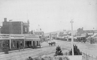 Stawell Historical Society Inc
Photograph, Main Street Stawell looking East from the Present War Memorial site 1878
Main St. looking East towards Big Hill from Coffee Palace Verandah over Present War Memorial area. 1878 Businesses from left Walters and Son Factory, General Furnishing Mart, Stawell Town Hall, J. & A. Price Wine Spirits & Provision Merchants, Stawell Post Office. On right south side of Main Street, two-storey wooden Bull & Mouth Hotel, Whiteside Taylors, Carters Boot shop, Lecky Draper, C. Mulcahy Post Office Hotel, G.J. Hewlett Baker & Confectionery, Iron Monger, Victoria House Bond Draper, Town Hall Hotel, J. Richards Fancy Repository. Victorian Views. C. Herbert, Photo. Stawell 1878stawell business streetscape -
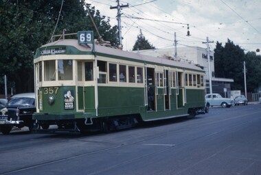 Melbourne Tram Museum
Slide, John Webster, 15/03/1960 12:00:00 AM
Colour slide, Kodak, white cardboard of Tram W2 357, with the number above the headlight, route 69, St Kilda Beach via Balaclava in Glenferrie Road Malvern. Has advert for White Horse Whiskey. Slide dated 15-3-60.Hand writing on rear in ink "15-3-60 - Tram 357, number raised, Glenferrie Road, Malvern Vic>"trams, tramways, st kilda beach, route 69, w2 class, glenferrie rd, tram 357 -
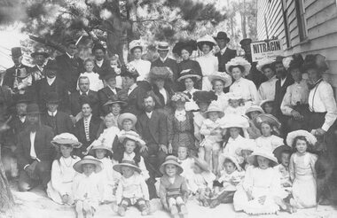 Ringwood and District Historical Society
Photograph, Group at Ringwood Show at Ringwood East old hall. 1908
Written below photograph, 'Photo by Frazer & Vallance. Salisbury Buildings. C/o Bourke & Queen Sts., Melbourne." Written on back of photograph, 'Ringwood Show at old Hall, Ringwood East.' Typed below another copy, 'Celebration held at Ringwood Hall, Mt. Dandenong Rd. 1908. Hall burnt down 1909.' Last photograph has typed below picture, 'Ringwood residents at Old Ringwood Hall near Club Hotel in Mt. Dandenong Rd. circa 1900.'