Showing 2126 items
matching map of bendigo
-
 Bendigo Historical Society Inc.
Map - EPPALOCK, 3/07/1890
... Inc. History House 11 Mackenzie Street Bendigo goldfields MAP ...Map: Parish of Eppalock. County of Bendigo. Parish plan (number 338 in map cupboard 1)map, bendigo, parish plan, eppalock -
Bendigo Historical Society Inc.
Map - LYELL, 24/09/1907
... Inc. History House 11 Mackenzie Street Bendigo goldfields MAP ...Map: Parish of Lyell, County of Bendigo. Parish plan (number 337 in map cupboard 1)map, bendigo, parish plan, lyell -
Bendigo Historical Society Inc.
Map - CRAVEN'S ALLOTMENTS , NEW CHUM, No date visible
... Inc. History House 11 Mackenzie Street Bendigo goldfields MAP ...Map: Craven's Allotments, New Chum. Hand Draughted plan showng the corner of McKenzie and Rose streets Bendigo.map, bendigo, allotments, cravens allotments, new chum -
Bendigo Historical Society Inc.
Map - SANDHURST, Circa 1906
... Inc. History House 11 Mackenzie Street Bendigo goldfields MAP ...Map: Parish of Sandhurst, County of Bendigo. Parish planmap, bendigo, parish plan, sandhurst -
Bendigo Historical Society Inc.
Map - HUNTLY, SHEET 4, 29/03/1876
... Inc. History House 11 Mackenzie Street Bendigo goldfields MAP ...Map: Parish of Huntly, Sheet 4, County of Bendigo. Hand Draughted Parish plan. Originally in Map Cupboard. Relocated to Map Drawer 5 on 22.9.22. Too long for the map cupboard.map, bendigo, parish plan, huntly -
Bendigo Historical Society Inc.
Map - NEILBOROUGH, 6/12/1882
... Inc. History House 11 Mackenzie Street Bendigo goldfields MAP ...Map: Parish of Neilborough, County of Bendigo. Parish plan. Earliest date on map 21/8/1877.map, bendigo, parish plan, neilborough -
Bendigo Historical Society Inc.
Map - NEILBOROUGH, 21/01/1875
... Map: Parish of Neilborough, County of Bendigo. Hand... Inc. History House 11 Mackenzie Street Bendigo goldfields MAP ...Map: Parish of Neilborough, County of Bendigo. Hand Draughted Parish plan. Map dated 21/1/1875.map, bendigo, parish plan, neilborough -
Bendigo Historical Society Inc.
Map - EGERTON, 28/01/1896
... Inc. History House 11 Mackenzie Street Bendigo goldfields MAP ...Map: Parish of Egerton, County of Bendigo. Parish plan. (number 335 in map cupboard 1)map, bendigo, parish plan, egerton -
Bendigo Historical Society Inc.
Map - CALAVIL, 28/08/1874
... Inc. History House 11 Mackenzie Street Bendigo goldfields MAP ...Map: Country Lands, Parish of Calavil, County of Bendigo. Parish plan (number 334 in map cupboard 1)map, bendigo, country lands, country lands, parish of calavil -
Bendigo Historical Society Inc.
Map - BALLENDELLA, 12/06/1882
... Inc. History House 11 Mackenzie Street Bendigo goldfields MAP ...Map: Parish of Ballendella, County of Bendigo. Parish plan (number 333 in map cupboard 1)map, bendigo, parish plan, ballendella -
Bendigo Historical Society Inc.
Map - GRAZING ALLOTMENTS, 15/10/1894
... Inc. History House 11 Mackenzie Street Bendigo goldfields MAP ...Map: Grazing Allotments, Parishes of Whirrakee and Bagshot, County of Bendigo. Parish plan (number 331 in map cupboard 1)map, bendigo, grazing allotments, grazing allotments, whirrakee, bagshot -
Bendigo Historical Society Inc.
Map - AVAILABLE ALLOTMENTS, 10/08/1908
... Inc. History House 11 Mackenzie Street Bendigo goldfields MAP ...map: Available Allotments, Parishes of Whirrakee, Bagshot and Egerton, County of Bendigo. Parish plan (coloured) (number 330 in map cupboard 1)map, bendigo, allotments, available allotments, whirrakee, bagshot, egerton -
Bendigo Historical Society Inc.
Map - BAGSHOT, Circa 1878
... Inc. History House 11 Mackenzie Street Bendigo goldfields MAP ...Map: Parish of Bagshot, County of Bendigo. Parish plan (coloured) (number 329 in map cupboard 1)map, bendigo, parish plan, bagshot -
Bendigo Historical Society Inc.
Map - MARONG, 16/08/1881
... Inc. History House 11 Mackenzie Street Bendigo goldfields MAP ...Map: Parish of Marong, County of Bendigo. Parish plan (number 328 in map cupboard 1)map, bendigo, parish plan, marong -
Bendigo Historical Society Inc.
Map - EPPALOCK, 3/11/1882
... Inc. History House 11 Mackenzie Street Bendigo goldfields MAP ...Map: Parish of Eppalock, County of Bendigo. Parish plan (number 327 in map cupboard 1)map, bendigo, parish plan, eppalock -
Bendigo Historical Society Inc.
Map - GOORNONG, 29/04/1879
... Inc. History House 11 Mackenzie Street Bendigo goldfields MAP ...Map: Parish of Goornong, County of Bendigo. Parish plan (coloured) (number 326 in map cupboard 1)map, bendigo, parish plan, goornong -
Bendigo Historical Society Inc.
Map - FARADAY, 10/01/1879
... Inc. History House 11 Mackenzie Street Bendigo goldfields MAP ...Map: Parish of Faraday, County of Talbot. Parish plan. Earliest date on map December 1877.map, talbot, parish plan, faraday -
Bendigo Historical Society Inc.
Map - DARGILE, 14/10/1906
... Inc. History House 11 Mackenzie Street Bendigo goldfields MAP ...Map: Parish of Dargile, County of Rodney. Parish plan (number 324 in map cupboard 1)map, rodney, parish plan, dargile -
Bendigo Historical Society Inc.
Map - LEICHARDT, 23/05/1875
... Inc. History House 11 Mackenzie Street Bendigo goldfields MAP ...Map: Parish of Leichardt, County of Bendigo. Parish plan (coloured). Attached plan in the top left hand corner marked 'Building Lots' (number 323 in map cupboard 1)map, bendigo, building lots, leichardt -
Bendigo Historical Society Inc.
Map - TOWNSHIP OF LOCKINGTON, 21/09/1915
... Inc. History House 11 Mackenzie Street Bendigo goldfields MAP ...Map: Township of Lockington, Parish of Bamawm, County of Bendigo. Parish plan.Has a clipping from 'The Riverine Herald' dated 20/11/1915 on the reverse side re. the sale of blocks in Bamawm Township (number 322 in map cupboard 1)map, bendigo, township, lockington, bamawm, the riverine herald -
Bendigo Historical Society Inc.
Map - WELLSFORD, 15/10/1903
... Inc. History House 11 Mackenzie Street Bendigo goldfields MAP ...Map: Parish of Wellsford, County of Bendigo. Parish plan (number 321 in map cupboard 1)map, bendigo, parish plan, wellsford -
Bendigo Historical Society Inc.
Map - HEATHCOTE, 11/04/1935
... Inc. History House 11 Mackenzie Street Bendigo goldfields MAP ...Map: Parish of Heathcote, County of Dalhousie. Parish plan (number 320 in map cupboard 1)map, dalhousie, parish plan, heathcote -
 Bendigo Historical Society Inc.
Map - SANDHURST SHEET 3, June 29th 1967
... Inc. History House 11 Mackenzie Street Bendigo goldfields MAP ...Map: Sandhurst sheet 3. Parish plan.map, bendigo, city streets, sandhurst, early bendigo -
 Bendigo Historical Society Inc.
Map - SANDHURST SHEET 2, March 12th 1867
... Inc. History House 11 Mackenzie Street Bendigo goldfields MAP ...Map: Sandhurst sheet 2 . Parish plan.map, bendigo, city streets, sandhurst, early bendigo -
 Bendigo Historical Society Inc.
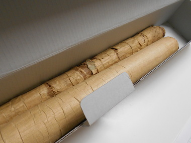
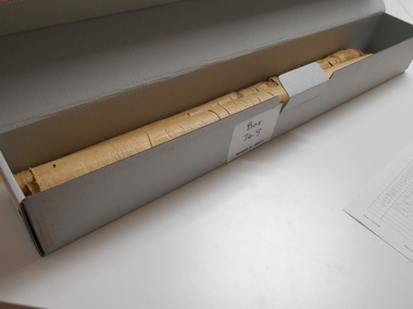
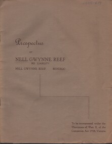
Document - MCCOLL, RANKIN AND STANISTREET COLLECTION: NELL GWYNNE REEF N/L - PROSPECTUS, 1938
Document. Slim, stapled Greybrown book. Nell Gwynne Reef N/L Prospectus. Contains underground maps.McColl, Rankin & Stanistreetorganization, business, nell gwynne reef mine, mccoll, rankin & stanistreet, nell gwynne reef n/l, gold mining, prospectus -
Bendigo Historical Society Inc.
Map - COUNTY OF GLADSTONE, November 1910
... Inc. History House 11 Mackenzie Street Bendigo goldfields MAP ...Map: County of Gladstone, Geological survey of Victoria. Geological mapmap, gladstone, geological, county of gladstone, geological map -
Bendigo Historical Society Inc.
Map - SHEEPSHEAD LINE OF REEF, Circa 1940's
... Inc. History House 11 Mackenzie Street Bendigo goldfields MAP ...Map: Plan showing a Longitudinal section of the Sheepshead line of Reefs , Bendigo. (34 Copies)map, bendigo, mining plan, sheepshead line of reef, gold mines , mining -
Bendigo Historical Society Inc.
Map - PART OF ELLESMERE, 20/06/1875
... Inc. History House 11 Mackenzie Street Bendigo goldfields MAP ...Map: Re-survey of part of the Parish of Ellesmere, hand draughted Parish plan Reloacated to Map Drawer 5 on 22.9.2022. Hanging strip detached.map, bendigo, parish plan, ellesmere -
Bendigo Historical Society Inc.
Map - TALAMBE, 26/11/1880
... Inc. History House 11 Mackenzie Street Bendigo goldfields MAP ...Map: Parish of Talambe, County of Bendigo. Parish plan (number 315 in map cupboard 1)map, bendigo, parish plan, talambe -
Bendigo Historical Society Inc.
Map - PANNOOBAMAWM, 6/11/1882
... Inc. History House 11 Mackenzie Street Bendigo goldfields MAP ...Map: Parish of Pannoobamawm, County of Bendigo, Parish plan (number 314 in map cupboard 1)map, bendigo, parish plan, pannoobamawm