Showing 112723 items
matching tracks/roads
-
 Whitehorse Historical Society Inc.
Article, Plan on freeway, 3/11/1992 12:00:00 AM
Nunawading's Corporate business committee called for a meeting with state politicians and Ministers for Transport through the revised Mayoral Committee to achieve full construction of the Eastern Freeway and have construction of the freeway concurrent from Ringwood to Doncaster within four years.Nunawading's Corporate business committee called for a meeting with state politicians and Ministers for Transport through the revised Mayoral Committee to achieve full construction of the Eastern Freeway and have construction of the freeway concurrent from Ringwood to Doncaster within four years. It will call on the Minister for Roads to prepare a strategy incorporating funding, construction standards and staging. The only government commitment was construction to Springvale Road in the first four years and Ringwood to be considered in the government's second term.Nunawading's Corporate business committee called for a meeting with state politicians and Ministers for Transport through the revised Mayoral Committee to achieve full construction of the Eastern Freeway and have construction of the freeway concurrent from Ringwood to Doncaster within four years.freeways, city of nunawading, eastern freeway extension, cooper, les, pescott, roger -
Whitehorse Historical Society Inc.
Document, Wedding of Bruce Roy Mullens to Thelma Lowen, 1936
Certificate of Marriage of Bruce Roy Mullens to Thelma Mary Lowen, 20 June 193.Certificate of Marriage of Bruce Roy Mullens to Thelma Mary Lowen, 20 June 1936 at Methodist Parsonage, Bedford Road Ringwood. Methodist minister Fred Flentje.Certificate of Marriage of Bruce Roy Mullens to Thelma Mary Lowen, 20 June 193. mullens, bruce roy, lowen, thelma mary, orchardists, marriage certificates -
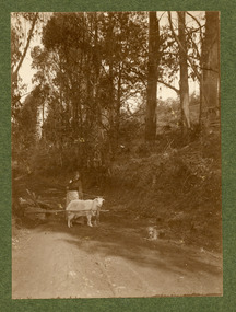 Mt Dandenong & District Historical Society Inc.
Photograph
The photograph is most likely taken on Child's Road in Kalorama in the early 1900s.Black and white photograph mounted on dark green cardboard showing a woman on a road with a cart loaded with gathered wood htiched to a white goat. A dog is sitting at the roadside.childs road, kalorama, goat, wood collection, wood, cart -
Whitehorse Historical Society Inc.
Article, Looking back to a rural past, Tally Ho corner, 1986
Article on the Parsons Family of Tally Ho in the 1920s.Article on the Parsons Family of Tally Ho in the 1920s, and on Alan ('Pete') Angus, Australian Road cycling champion, deceased soldier of World War II.Article on the Parsons Family of Tally Ho in the 1920s.tally ho, blacksmiths, cycling, angus, alan, parsons, william -
 City of Kingston
Pamphlet - Colour, Ozone Hill Estate, Cheltenham, 1923
Sales plan for land in the suburb of Cheltenham, along both sides of Victori Avenue, off Weatherall Road.The developing urban area of Cheltenham within the City of Kingston. This land sale pamphlet illustrates the subdivision of land within the municipality and the changing demographic of the district as new houses are constructed.Colour pamphlet advertising for sale the Ozone Hill Estate, Cheltenham. Incorporates a map of the estate on either side of Victor Avenue, off Weatherall Road. Handwritten in blue ink on the subdivision map: 'Sold' is written on subdivisions 1-4, 8, 11, 13, 16-26, 28, 29, 33, 39-41 Handwritten in blue ink on the subdivision map: 'House being erected' is written on subdivisions 22 and 33. Handwrittten in grey pencil adjacent to subdivisions 21 and 22: Tennis / Courts / being / constructed / here Handwritten in grey pencil at bottom of page: Revised to 30/1/24 Handwritten in grey pencil on subdivision map: assumed land sale price is recorded on subdivisions 5-9, 9-10, 12, 14-15, 27, 30-32, 34-38. land sales, cheltenham, estate -
Whitehorse Historical Society Inc.
Map, Parish of Nunawading, 1939
Plan of subdivision part of crown portions 81, 82 and 89,Plan of subdivision part of crown portions 81, 82 and 89, Parish of Nunawading, County of Bourke, Blackburn Wellington Avenue amended from Stanley RoadPlan of subdivision part of crown portions 81, 82 and 89, street names, parish of nunawading, blackburn road, blackburn, wellington avenue, blackburn, wolseley crescent, blackburn, gordon crescent, blackburn, clarke street, blackburn, central road, blackburn -
Whitehorse Historical Society Inc.
Pamphlet - Newsletter, U3A Nunawading Newsletter, 2010
Newsletter of the University of the Third Age Nunawading. No.74 Sep 2010.Newsletter of the University of the Third Age Nunawading. No.74 Sep 2010 incl. photos of Springvale Road railway crossing. See Series Contents card for holdingsNewsletter of the University of the Third Age Nunawading. No.74 Sep 2010.springvale road nunawading, nunawading railway station, u3a nunawading -
Whitehorse Historical Society Inc.
Article, Blackburn South Retirement Village, 2016
Regis Inala has received council's approval to build five buildings.Regis Inala has received council's approval to build five buildings of between four and six storeys at the site at 220 Middleborough Road, Blackburn South.Regis Inala has received council's approval to build five buildings. inala village, middleborough road, blackburn south no. 220 -
Port Melbourne Historical & Preservation Society
Flyer - Invitation to planning meeting re campaign against converting the Railway Reserve to a road, Anne Callaghan, 19 Dec 1988
Friends of the Park was established to campaign against the proposal to turn the Railway Reserve into a major road to service the proposed Bayside development. Anne Callaghan was the convenor.Handwritten photocopied invitation to a planning meeting to campaign against converting the Railway Reserve to a major road, an aspect of the 'Bayside' redevelopment, 1988public action campaigns, societies clubs unions and other organisations, transport, parks and gardens, town planning - proposals shelved - bayside, anne callaghan, friends of the park, railway reserve -
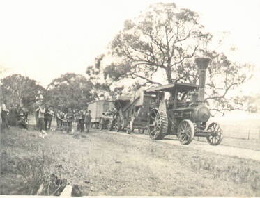 Sunbury Family History and Heritage Society Inc.
Photograph, Traction engine
Steam-driven traction engines had a variety of uses on farms before petrol and diesel power motors were developed. The one in the photograph is hauling a farm shed to a specific location.A non-digital black and white photograph of a steam-driven traction engine pulling hauling equipment and a small wooden building along an unmade track. A group of men are standing at the rear by the track supervising the shift. There are trees in the paddock.steam-driven traction engines, farms -
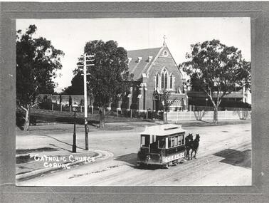 Melbourne Tram Museum
Photograph - Black & White Photograph/s, 1900's
Photograph - Copy photograph of a Black and white of a Coburg horse tram No. 5, southbound in Sydney Road with St Paul's Catholic Church in background. See notes below for details of the photograph.In ink on the rear: "Melbourne - Original photograph in the possession of Father Norris St Paul's Roman Catholic Church, Sydney Road Coburg. Photo supplied by R. W. Green December 1969. Photograph taken from the upper floor of the hotel at the corner of Sydney Road (foreground) and Church St (left). The iron picket fence at left is that around the Pentridge Stockade. Photograph undated" KSK print number BWG1.trams, tramways, horse trams, coburg, sydney rd, pentridge prison, tram 5 -
Melbourne Tram Museum
Pamphlet, Public Transport Victoria (PTV), "Buses replace trams - route 3, 3A, 5, 6, 16, 64, 67", March/April 2020
Issued for track work in St Kilda Road at High St and and St Kilda junction, between 3 April and 12 April 2020. Gives details of the replacement and alternative bus routes. Produced by Yarra Trams and the PTV.Yields information about track work in St Kilda Road during 2020.Pamphlet - full colour DL 6 fold.trackwork, tramways, st kilda road, high st -
 Kew Historical Society Inc
Plan - Subdivision Plan, Lodged Plan No.6518, 1920-1940
The Kew Historical Society collection includes almost 100 subdivision plans pertaining to suburbs of the City of Melbourne. Most of these are of Kew, Kew East or Studley Park, although a smaller number are plans of Camberwell, Deepdene, Balwyn and Hawthorn. It is believed that the majority of the plans were gifted to the Society by persons connected with the real estate firm - J. R. Mathers and McMillan, 136 Cotham Road, Kew. The Plans in the collection are rarely in pristine form, being working plans on which the agent would write notes and record lots sold and the prices of these. The subdivision plans are historically significant examples of the growth of urban Melbourne from the beginning of the 20th Century up until the 1980s. A number of the plans are double-sided and often include a photograph on the reverse. Reconciling this hand-drawn subdivision plan with a modern map of the area is initially a challenge due to a change of street names. Argyle Road in the centre of the subdivision was to be renamed Deepdene Road, and the street named Deepdene Road on the plan was to become Deepdene Place. Of interest is the nursery on the corner of Argyle and Whitehorse Roads. During this period there were a number of nurseries servicing the Kew and Balwyn areas. The subdivision was essentially of the land formerly occupied by the house 'Deepdene'.subdivision plans - balwyn, deepdene, whitehorse road -- deepdene (vic.), deepdene road -- deepdene (vic.), burke road -- deepdene (vic.) -
 Melbourne Tram Museum
Document - Folder of Track crossections drawings, Melbourne & Metropolitan Tramways Board (MMTB), c1928
The document provides cross sections of track used from c1920 to 1928. The folder is marked "H Bell" most likely the son of the later Chairman, Mr Hector Bell who was a civil engineer with the MMTB. 1 - P3948 - Camberwell Road - 1926 2 - P2789 - Camberwell Road reconstruction - 1920 3 - P3753 - Chapel St - 1926 4 - P60 - Expansion joints Church St bridge - 1924 5 - P3686 - Commercial Road reconstruction - 1926 6 - P4024 - Cotham Road reconstruction - 1927 7 - P4699 - Droop St duplication - 1927 8 - P2384 - Flemington Road conversion - 1925 9 - P1187 - Flemington Road tramway - undated c1920 10 - P4131 - Flinders St conversion - 1927 11 - P4132 - Flinders St conversion - special track drains where subject to flooding - 1927 12 - P3603 - Glenferrie Road east track - 1926 13 - P2608 - Glenferrie Road reconstruction - 1925 14 - P3577 - Glen Huntly Road extension - 1926 15 - P3745 - Glen Huntly Rd duplication - 1926 16 - P4655 - Gilbert Rd duplication - 1928 17 - P2472 - Hannah St at Crossings 1925 18 - P2459 - Hannah St in plantations - 1925 19 - P2582 - High St Prahran reconstruction - 1926 20 - P1594 - High St Prahran reconstruction - 1925 21 - P3611 - High St Malvern reconstruction - 1926 22 - P3900 - Lygon St - 1926 23 - P3689 - Malvern Road reconstruction - 1926 24 - P3951 - West Coburg Route - sleeper spacing - 1926 25 - P4703 - Nicholson St Coburg - duplication - 1928 26 - P4470 - Norwood Road duplication - 1927 27 - P2473 - Park St tramway - 1925 28 - P3707 - Riversdale Road reconstruction - 1926 29 - P4630 - Riversdale Road extension - 1927 30 - P4497- Riversdale Road duplication - 1927 31 - P1387 - South Melbourne Road - special boxed in Construction for Albert Road (parking loop) - 1924 32 - P4691 - Swan St reconstruction - 1927 33 - P3640 - Victoria St part - 1926 (2 copies) 34 - P4522 - Wallen Road reconstruction - 1927 35 - P3939 - Wallen Road reconstruction in front of depot - 1927 36 - P4702 - Trial types of track - 1928 37 - P4254 - Wattletree Road reconstruction - 1927 38 - P4531 - Wattletree Road connection to Glenferrie Road - 1927 39 - P4708 - Wellington Rd siding - 1928Yields information about the various tramway track cross sections used by the MMTB including cable tram conversions.Folder - heavy card cloth covers fitted with two interscrews containing some 39 plus one duplicate folded blue prints. Covers made by Swinnerton Bros of Melbourne - see image 6 for their logo/trademark.Has "H Bell" in ink on rear cover.tramways, mmtb, tram tracks, rails, civil engineering, cable conversion, new tramways -
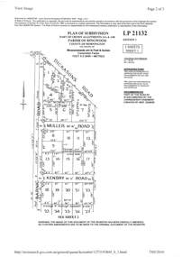 Ringwood and District Historical Society
Document - Subdivision Plan, LP21132 Part of Crown Allotment 14A & 14B, Parish of Ringwood, County of Mornington Vol 4929 Fol 657 - (Undated, circa 1920s/30)
LANDATA Land Victoria 2-sheet plan printout dated 2010.Sheet 1 includes Dickasons Road, Barnic Road, Muller Road and Kenbry Road, Heathmont. Sheet 2 includes Barnic Road and Possum Lane, Heathmont. Additional markings include LP83779. -
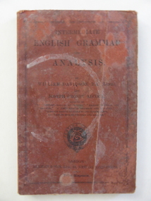 Warrnambool and District Historical Society Inc.
Book, Allman and Son, Intermediate English Grammar & Analysis, Early 20th century
This is a school text book used at Wangoom State School by members of the Giles family. The book contains the names of Allan Giles and Henrietta Giles. The Giles family lived on the Allansford Road. Wangoom School was established in 1865 as the Wangoom Common School No. 645 and later became known as Wangoom State School. It is now closed. This book is of interest as an example of an English Grammar book used in Victoria early in the 20th century. It is also of interest as a school book used by members of the Giles family, early settlers in the Warrnambool area.This is a soft cover book of 80 pages. The cover is dark red with black lettering and an ornamental border. The cover is very stained and worn. At the front and the back of the book and on the back cover are advertisements for other books published by Allman and Son. The inscriptions are handwritten in black ink and pencil. There is a purple stamp of the Warrnambool and District Historical Society on the first page of the text. ‘Allan Giles, Wangoom State School No. 645’ ‘Henrietta R.V. Giles, Allansford Road’ wangoom state school, giles family, history of warrnambool -
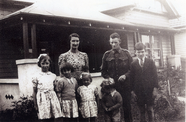 Whitehorse Historical Society Inc.
Photograph, Green Family. Mitcham, c1943
No 172 Mitcham Road has been replaced by a large brick home and is now numbered 374 Mitcham Road, Mitcham.Two black and white photo of George and Irene Green in front of their home ar 172 Mitcham Road, Mitcham (cnr Mitcham & Ormond Ave) with their children Maitland (elder son), Eunice (Esme), Yenice, Anslee and Ashley.green george, green irene, green family, mitcham road, mitcham 172, ormond ave -
 Eltham District Historical Society Inc
Brochure, 'Illilawa', Research
Timber Cottage circa 1881 at 35 Ingrams Road, Research.Printed Real Estate brochure of 'Illilawa', Ingrams Road, Kangaroo Ground featuring pretty stucco and timber cottage, bay windows, open fireplaces, loads of charm and character.houses, research, illilawa, ingrams road -
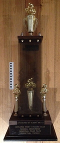 Geelong Cycling Club
Trophy, Circa mid 1950s
This trophy was sponsored by Albert Batty in recognition of Russell Mockridge - an Olympic cyclist who was a member of the GWCC. He died in a tragic accident at an early age during a road race in Melbourne.This trophy is in memory of Russell Mockridge.Large trophy made of perspex, wood and gold coloured plastic. The wooden base has wording embossed in gold coloured lettering. On top of the base sits 3 cyclists on columns, together with two perplex panels with wooden top and another cyclist on a trophy placed above the wooden top."SPONSORED BY ALBERT BATTY/GEELONG WEST CYCLING CLUB/RUSSELL MOCKRIDGE/MEMORIAL ROAD RACE/PERPETUAL TROPHY"albert batty; geelong west cycling club; russell mockridge; road race; -
 Whitehorse Historical Society Inc.
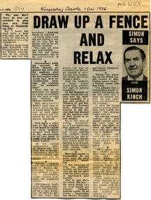
Article, Draw up a fence and relax, 1976
Column by journalist Simon Kinch.Column by journalist Simon Kinch, including musings on council requirements for fence plans, road traffic problems in Vermont South and the meanings of the acronym NADRASCAColumn by journalist Simon Kinch.fences, vermont south, nadrasca -
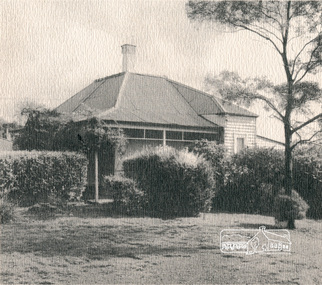
 Whitehorse Historical Society Inc.
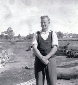
Photograph, John Williams
The Mitcham Reservoir was completed in 1923. Excavation was by horse drawn scoops and drays. The site is accessed by Agra Road MitchamTwo copies of a black and white photograph of John Williams of East Doncaster Road, Mitcham, standing in front of the Mitcham Reservoir construction site in c1922williams, john, mitcham reservoir -
 Lara RSL Sub Branch
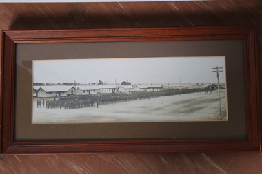
Photograph (2 off), H.B. Chesterfield, 1918
YMCA and Salvation Army Barracks , Victoria (Broadmedows Military Camp, Camp road)Photograph - Parade of a Battalion of Troops in Camp - Broadmedows Military Camp, Camp road - H.B. Chesterfield 18-12-1918 ( two identical prints ) (447.1 & 447.2)447.1 marking on reverse states H. B. Chesterfield, Lara 18/12/18 447.2 Marked by photographer front lower right hand corner "Faling & Co, Swanston Street, Melbourne"world war 1 troop on parade 1918, victoria, broadmedows military camp, camp road -
 Bendigo Military Museum
Photograph - SERVICEMAN'S CLUB, C.1993
These photos show the early renovations to the Bendigo District Servicemen’s Club in 1993 Havilah Road. Refer Cat No's 8073P, 8171 & 8230.2 for more history..1) - .6) Series of 6 photographs colour showing early stages to the renovations of the Bendigo District Servicemen’s Club in Havilah Road.brsl, smirsl, bdsc, renovations -
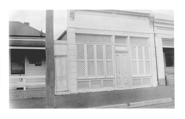 Tarnagulla History Archive
Photograph of latticed shopfront at 98 Commercial Rd, Tarnagulla, Late 1960s
Murray Comrie Collection. Building is still on Commercial Road and in 2019 is a private residence. History to be confirmed.Monochrome photograph depicting a latticed shopfront, which is located at 98 Commercial Road, Tarnagulla. Small portion of building visible at far right was demolished in the 1990s.tarnagulla, commercial road, buildings, houses -
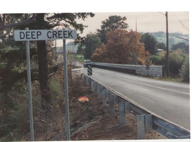 Sunbury Family History and Heritage Society Inc.
Photograph, Bulla, C 1980s
The photograph shows the approach to the Bulla Bridge at Deep Creek in the Township of Bulla. Immediately on crossing the bridge there is a sharp bend in the road and a step ascent up Bulla Hill through the cutting until level ground is reached. The photograph is looking to the NW. Deep Creek meets the Maribyrong River further downstream and closer to Keilor.The bridge and road replaced the ford crossing in 1869 that was downstream from the bridge.A coloured photograph of the approach to a bridge over the Deep Creek at Bulla along Sunbury Road. bulla bridge, deep creek, sunbury road -
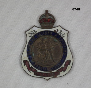 Bendigo Military Museum
Badge - BADGE, RETURNED SERVICEMEN
Style of badge worn by returned soldiers and sailors from WW1. Started 1919 to early Ww2 by the organisation, "The Imperial League".Shield shaped badge with small crown on top. White background with blue circle and images of standing soldier and sailor in the middle.Engraved Ïmperial League" Returned sailors and soldiers". On back engraved P9043 to enable tracking of individual.passchendaele barracks trust, ww1, returned service league, badge -
Glenelg Shire Council Cultural Collection
Photograph, Entrance Gates to Island Park Casterton, c. 1963
SOURCED FROM CASTERTON TOWN HALL (FORMER SHIRE OF GLENELG)Black and white photo showing entrance gates to Island Park CastertonBack: 'Entrance gates and track leading to oval at Island Park Casterton' - handwritten, green biro -
 Ringwood and District Historical Society
Photographs, 1979-80 MMBW pipe line project at Hubbard Reserve, North Ringwood � Air track drill rig
Part of a 43-photo record of the MMBW�s engineering feat in drilling a 12 inch pipe line up to 40 feet deep through rock hardened by volcanic action associated with geological fault that occurs along the line. The work took place from October 1979 to May 1980 on the southern boundary of Hubbard Reserve, North Ringwood. The collection was presented to the Ringwood Historical Research Group by J Clarke on 9th June 1980.E561 N19 3 March 1980 A43 Air track drill rig in position as in N18 -
 Hume City Civic Collection
Photograph, early 1990s
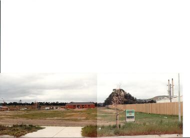
The series of 5 photographs feature different views of the Woodlands housing development which opened up land bounded by Gap and Anderson Roads, Cornish Street and Elizabeth Drive in the early 1990s. It was a large housing development built close to Sunbury township.A view of the northern boundary of the Woodlands housing development in Anderson Road. A paling fence divides the estate from the 'Malley' factory, now 'Storage King' which is on the corner of Cornish Street and Anderson Road. A 'For Sale' sign is in the foreground and a partly built house is in the middle distance.housing developments, anderson road, george evans collection -
 Whitehorse Historical Society Inc.
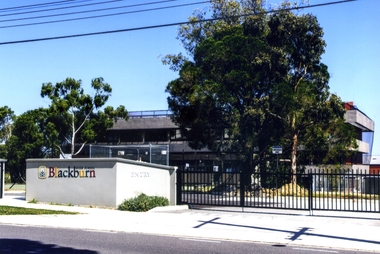
Photograph, Blackburn High School, 2012
The Blackburn High School opened on 1st February 1956 with 128 Form 1 pupils and a staff of 8. The 20-acre site on the corner of Williams and Springvale road was surrounded by orchards and pine trees. The trees inspired the school motto: ' Ad licem crescimus' - 'We are growing towards the light'. The first headmaster was Mr V. Percy. The school had a reputation for musical excellence.Coloured photograph of the Blackburn High School in Springfield Road facing north 2012blackburn high school, schools