Showing 12610 items matching " development"
-
 Bendigo Historical Society Inc.
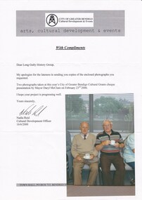
Photograph - LONG GULLY HISTORY GROUP COLLECTION: ENJOYING A CUP OF TEA
Coloured photo of two elderly gentlemen enjoying a cup of tea. Photo is accompanied by a letter from the City of Greater Bendigo Cultural Development & Events. Letter is addressed to the Long Gully History group and dated 16/6/2000, from Nadia Reid, Cultural Development Officer. Writer is apologising for the lateness in sending the copies of the photographs that were requested. Two photographs taken at this year's City of Greater Bendigo Cultural Grants cheque presentation by Mayor Daryl McClure on February 23rd 2000. Unknown person on left, George Ellis, in horizontal striped T shirt.bendigo, history, long gully history group, the long gully history group - enjoying a cup of tea, city of greater bendigo cultural development & events, long gully history group, daryl mcclure, nadia reid -
 Falls Creek Historical Society
Document - S.E.C. - Falls Creek Tourist Hotel Project (Adjacent To Ski Village)
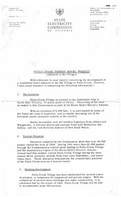
Bob (Herman) Hymans (a former member of the Royal Netherlands Navy) was born in Bloemendaal, Holland on 30th September 1922. During World War II he fought against the Japanese in the Dutch East Indies (now Indonesia) and was imprisoned in Changi and on the Burma Railway. After gaining qualifications as a Ski Instructor, Bob arrived in Falls Creek in July 1950. Working as an Instructor and Supervisor at Bogong Lodge, Bob decided his future was in accommodation. He was successful in negotiating an indenture for land from the State Electricity Commission (SEC). It took Bob two years to build his Grand Coeur Chalet but, tragically, it was burned down in August 1961. Bob also built the first Chairlift in Australia. This was a single chairlift and the structure was built from wooden electricity poles. He was constantly full of new ideas and proposals for the village. Bob Hymans died on 7th July 2007. This Collection of documents and letters tells the story of Bob's endeavours to develop Falls Creek into the ski village it is today.This item is significant because it documents plans made by the State Electricity Commission to develop the Falls Creek Tourist Area.A letter from the State Electricity Commission (SEC) outlining details of a site available for the development of a Tourist Hotel Project in Falls Creek in late 1962/3. The SEC estimated that by the winter of 1963 Falls Creek Village would be able to accommodate 500 persons. The site for development was up to 2 1/2 acres adjacent to the Upper Kiewa Valley Road. It envisaged a building able to accommodate about 100 guests. The successful developer would be granted a lease for 45 years at a rent of £300 per annum. Written applications for the lease were to be submitted by 31st March 1963.falls creek tourist area management committee, falls creek administration, state electricity commission -
 Warrnambool and District Historical Society Inc.
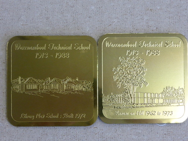
Souvenir - Warrnambool Technical School 1913-1988 souvenir coasters and placemats, 1988
These coasters and placemats are souvenirs of the 75th anniversary of the Warrnambool Technical School. The scenes depicted are Original Timor Street School built 1926, Timor Street with second storey 1967, New School built 1972. Dunkeld Annexe commenced 1975, Library new School built 1972, Annexe on Hill 1962 to 1978. They depict the ongoing development of the school which now operates as Brauer College in Caramut Road Warrnambool. Historical and social. A common item in the 20th century and as one of Warrnambool’s largest and longest running school would have some interest for a large number of local people. The artist John Moir was a local artist.Six White drink coasters with different black and white sketches. Rounded corners edged in black. In olive green box. Set two consists of two gilt metal coasters with engravings. Both are incorrectly labelled. Blue felt on the reverse. The scenes depicted are 000828.1.1 Original Timor Street School built 1926, 000828.1.2 Timor Street with second storey 1967, 000828.1.3 New School built 1972. 000828.1.4 Dunkeld Annexe commenced 1975, 000828.1.5 Library new School built 1972, 000828.1.6 Annexe on Hill 1962 to 1978. They depict the ongoing development of the school which now operates as Brauer College in Caramut Road Warrnambool. The two gilt metal coasters 000828.2.1 Library new School Built 1972 000828.2.2 Annexe on Hill 1962 to 1973 Placemats 000828.3.1 Original Timor Street School built 1926, 000828.3.2 Timor Street with second storey 1967, 000828.3.3 New School built 1972. 000828.3.4 Dunkeld Annexe commenced 1975, 000828.3.5 Library new School built 1972, 000828.3.6 Annexe on Hill 1962 to 1978.All have artist’s signature, John Moir, Warrnambool Technical School 1913-1988. warrnambool, warrnambool technical school, warrnambool annexe, timor street technical school, john moir, warrnambool souvenirs -
 Ringwood and District Historical Society
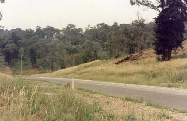
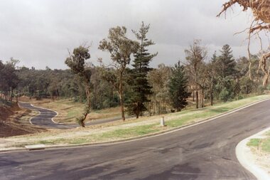
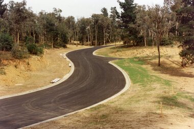
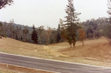
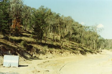
Photograph, View across junction of Wera (lower) and Manuelo (upper) Drives, North Ringwood showing how undergrowth had been cleared, February 1979
B552 N17 Part of a 51-photo record of the development of the "Kubis" Estate, Ringwood North, including road works to Debbie Place, Kubis Drive, Werac Drive, Manuelo Drive, Iluka Place and Glenvale Road. From the Jack Lundy Clarke collection. -
 Ringwood and District Historical Society
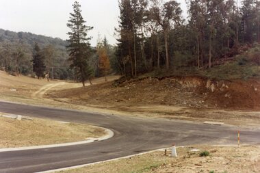
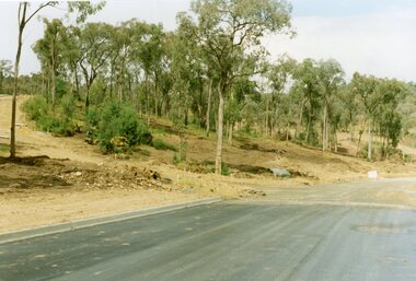
Photograph, Looking south up Werac Drive, North Ringwood past Manuelo Drive in February 1979
E552 N21 Part of a 51-photo record of the development of the "Kubis" Estate, Ringwood North, including road works to Debbie Place, Kubis Drive, Werac Drive, Manuelo Drive, Iluka Place and Glenvale Road. From the Jack Lundy Clarke collection. -
 Ringwood and District Historical Society
Photograph, Looking north down Werac Drive, North Ringwood with lake headwater's site behind light standard on left in February 1979
B552 N19 Part of a 51-photo record of the development of the "Kubis" Estate, Ringwood North, including road works to Debbie Place, Kubis Drive, Werac Drive, Manuelo Drive, Iluka Place and Glenvale Road. From the Jack Lundy Clarke collection. -
 Ringwood and District Historical Society
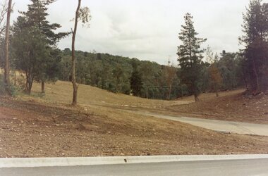
Photograph, The unfinished section of Debbie Place, North Ringwood in February 1979
E552 N23 Part of a 51-photo record of the development of the "Kubis" Estate, Ringwood North, including road works to Debbie Place, Kubis Drive, Werac Drive, Manuelo Drive, Iluka Place and Glenvale Road. From the Jack Lundy Clarke collection. -
 Ringwood and District Historical Society
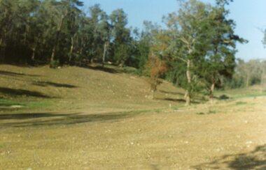
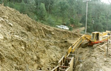
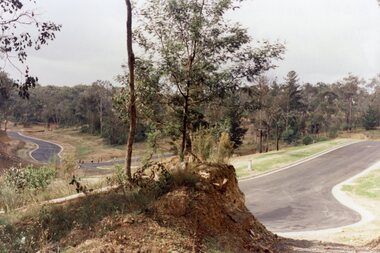
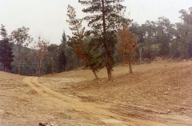
Photograph, Site of the main body of Loughnan's Lake, North Ringwood on 10 June 1978. the rope tree was on the slope, far left
E550 N6 Part of a 51-photo record of the development of the "Kubis" Estate, Ringwood North, including road works to Debbie Place, Kubis Drive, Werac Drive, Manuelo Drive, Iluka Place and Glenvale Road. From the Jack Lundy Clarke collection. -
 Ringwood and District Historical Society
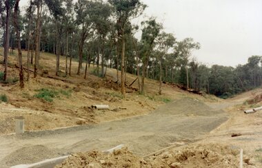
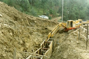
Photograph, Kubis Estate, North Ringwood on 16 June 1978, using the Kato as a crne to de-water final trench
E550 N9 Part of a 51-photo record of the development of the "Kubis" Estate, Ringwood North, including road works to Debbie Place, Kubis Drive, Werac Drive, Manuelo Drive, Iluka Place and Glenvale Road. From the Jack Lundy Clarke collection. -
 Ringwood and District Historical Society
Photograph, Kubis Estate, North Ringwood on 10 June 1978. Temporary end of Kubis Drive at junction with Debbie Place. The car stands at junction with Pamela Place
E550 N8 Part of a 51-photo record of the development of the "Kubis" Estate, Ringwood North, including road works to Debbie Place, Kubis Drive, Werac Drive, Manuelo Drive, Iluka Place and Glenvale Road. From the Jack Lundy Clarke collection. -
 Ringwood and District Historical Society
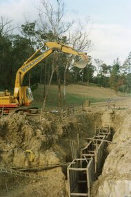
Photograph, Kubis Estate, North Ringwood on 16 June 1978. The Kato lifts a bucket out of the trench
E550 N11 Part of a 51-photo record of the development of the "Kubis" Estate, Ringwood North, including road works to Debbie Place, Kubis Drive, Werac Drive, Manuelo Drive, Iluka Place and Glenvale Road. From the Jack Lundy Clarke collection. -
 Ringwood and District Historical Society
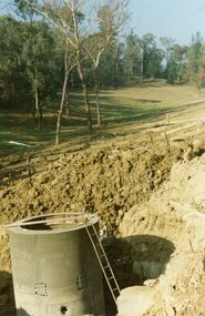
Photograph, Kubis Estate, North Ringwood on 16 June 1978. The concrete wall 27 feet deep at the pumping station in Glenvale Road
E550 N12 Part of a 51-photo record of the development of the "Kubis" Estate, Ringwood North, including road works to Debbie Place, Kubis Drive, Werac Drive, Manuelo Drive, Iluka Place and Glenvale Road. From the Jack Lundy Clarke collection. -
 Ringwood and District Historical Society
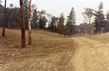
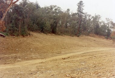
Photograph, Kubis Estate, North Ringwood in February 1978. The site of Loughnan's Lake seen from the north end of the wall. The rope tree was on the hillside on the left
E546 N2 Part of a 51-photo record of the development of the "Kubis" Estate, Ringwood North, including road works to Debbie Place, Kubis Drive, Werac Drive, Manuelo Drive, Iluka Place and Glenvale Road. From the Jack Lundy Clarke collection. -
 Ringwood and District Historical Society
Photograph, Kubis Estate, North Ringwood on 16 June 1978. Kato working on final trench. The hole for the 27 feet deep well is seen beyond the trench
E550 N10 Part of a 51-photo record of the development of the "Kubis" Estate, Ringwood North, including road works to Debbie Place, Kubis Drive, Werac Drive, Manuelo Drive, Iluka Place and Glenvale Road. From the Jack Lundy Clarke collection. -
 Ringwood and District Historical Society
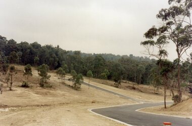
Photograph, Kubis Estate, North Ringwood in April 1978. View east up Kubis Drive from Jenkin Close past the foot of Werac Drive
E549 N16 Part of a 51-photo record of the development of the "Kubis" Estate, Ringwood North, including road works to Debbie Place, Kubis Drive, Werac Drive, Manuelo Drive, Iluka Place and Glenvale Road. From the Jack Lundy Clarke collection. -
 Ringwood and District Historical Society
Photograph, Kubis Estate, North Ringwood in April 1978. View east up Kubis Drive over Jenkin Close and intersection with Werac Drive
E549 N18 Part of a 51-photo record of the development of the "Kubis" Estate, Ringwood North, including road works to Debbie Place, Kubis Drive, Werac Drive, Manuelo Drive, Iluka Place and Glenvale Road. From the Jack Lundy Clarke collection. -
 Ringwood and District Historical Society
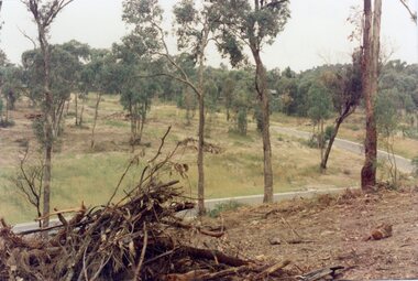
Photograph, Kubis Estate, North Ringwood in April 1978. Looking west across Kubis and Werac Drives over the full length of Loughnan's Lake site. Main pool was behind the lone pine
E548 N29 Part of a 51-photo record of the development of the "Kubis" Estate, Ringwood North, including road works to Debbie Place, Kubis Drive, Werac Drive, Manuelo Drive, Iluka Place and Glenvale Road. From the Jack Lundy Clarke collection. -
 Ringwood and District Historical Society
Photograph, Kubis Estate, North Ringwood in April 1978. Looking up the hill in Kubis Drive from the site of headwaters of Loughnan's Lake. Jenkins Close takes off to the right from centre
E548 N31 Part of a 51-photo record of the development of the "Kubis" Estate, Ringwood North, including road works to Debbie Place, Kubis Drive, Werac Drive, Manuelo Drive, Iluka Place and Glenvale Road. From the Jack Lundy Clarke collection. -
 Ringwood and District Historical Society
Photograph, Kubis Estate, North Ringwood in April 1978. Looking upstream from below the retaining wall of Loughnan's Lake that was where the truck tracks disappear. The wall was extended to the left across what was then a small gorge
E548 N19 Part of a 51-photo record of the development of the "Kubis" Estate, Ringwood North, including road works to Debbie Place, Kubis Drive, Werac Drive, Manuelo Drive, Iluka Place and Glenvale Road. From the Jack Lundy Clarke collection. -
 Ringwood and District Historical Society
Photograph, Kubis Estate, North Ringwood in April 1978. Looking west over site of Loughnan's Lake. The rope tree was on the slope to the right beyond the ridge with the lone pine
E548 N15 Part of a 51-photo record of the development of the "Kubis" Estate, Ringwood North, including road works to Debbie Place, Kubis Drive, Werac Drive, Manuelo Drive, Iluka Place and Glenvale Road. From the Jack Lundy Clarke collection. -
 Ringwood and District Historical Society
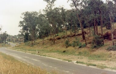
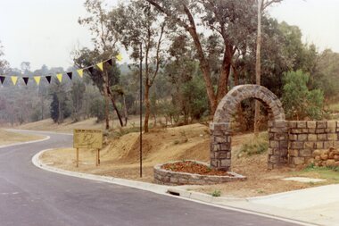
Photograph, Werac Drive, North Ringwood, entrance to Bel-Air Country Club in April 1978
E548 N11 Part of a 51-photo record of the development of the "Kubis" Estate, Ringwood North, including road works to Debbie Place, Kubis Drive, Werac Drive, Manuelo Drive, Iluka Place and Glenvale Road. From the Jack Lundy Clarke collection. -
 Ringwood and District Historical Society
Photograph, Loughnan Lake site over Kubis Drive, North Ringwood, on 14 April 1978. The retaining wall was where the car tracks disappear over the ridge where the spillway was
E548 N13 Part of a 51-photo record of the development of the "Kubis" Estate, Ringwood North, including road works to Debbie Place, Kubis Drive, Werac Drive, Manuelo Drive, Iluka Place and Glenvale Road. From the Jack Lundy Clarke collection. -
 Ringwood and District Historical Society
Photograph, "Kubis Estate", North Ringwood, in April 1978. Looking north-east over Loughnan's Lake greatest width. The rope tree was on the slope in the centre. The spillway was on the near left of the image
E548 N17 Part of a 51-photo record of the development of the "Kubis" Estate, Ringwood North, including road works to Debbie Place, Kubis Drive, Werac Drive, Manuelo Drive, Iluka Place and Glenvale Road. From the Jack Lundy Clarke collection. -
 Ringwood and District Historical Society
Photograph, Junction of Kubis Drive and Iluka Court, North Ringwood, in February 1979. Looking south with Hubbard Reserve beyond
E552 N25 Part of a 51-photo record of the development of the "Kubis" Estate, Ringwood North, including road works to Debbie Place, Kubis Drive, Werac Drive, Manuelo Drive, Iluka Place and Glenvale Road. From the Jack Lundy Clarke collection. -
 Ringwood and District Historical Society
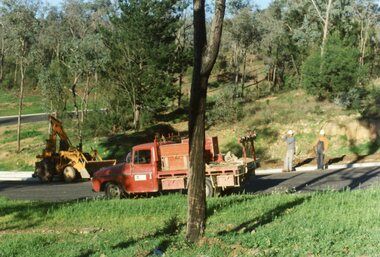
Photograph, The Telecom gang laying pipes in Kubis Drive, North Ringwood, near Jenkins Close, on 10th June 1978
E550 N5 Part of a 51-photo record of the development of the "Kubis" Estate, Ringwood North, including road works to Debbie Place, Kubis Drive, Werac Drive, Manuelo Drive, Iluka Place and Glenvale Road. From the Jack Lundy Clarke collection. -
 Ringwood and District Historical Society
Photograph, Looking east up the gully over the intersection of Werac and Kubis Drives, North Ringwood, in February 1978
E546 N3 Part of a 51-photo record of the development of the "Kubis" Estate, Ringwood North, including road works to Debbie Place, Kubis Drive, Werac Drive, Manuelo Drive, Iluka Place and Glenvale Road. From the Jack Lundy Clarke collection. -
 Ringwood and District Historical Society
Photograph, Corner of Pamela Court and Kubis Drive, North Ringwood, looking west on 3rd November 1978
E551 N15 Part of a 51-photo record of the development of the "Kubis" Estate, Ringwood North, including road works to Debbie Place, Kubis Drive, Werac Drive, Manuelo Drive, Iluka Place and Glenvale Road. From the Jack Lundy Clarke collection. -
 Ringwood and District Historical Society
Photograph, Looking west across Werac and Kubis Drives, North Ringwood, in April 1978. Loughnan's Lake site. The retaining wall was where the truck tracks disappear over thhe ridge. The spillway was at that spot
E548 N3 Part of a 51-photo record of the development of the "Kubis" Estate, Ringwood North, including road works to Debbie Place, Kubis Drive, Werac Drive, Manuelo Drive, Iluka Place and Glenvale Road. From the Jack Lundy Clarke collection. -
 Glenelg Shire Council Cultural Collection
Administrative record - Menu Card - National resources Development Train, 25/04/1939
Menu card for National Resources Development Train, April 18 to May 1 1939. Front cover same as 7936, 7937, 7938. Inside card, menu for dinner, Tues Apr. 25 1939, plus table of Victoria's prowess in industry and productionFront: 'B. VIVIAN' - handwritten -
 Ringwood and District Historical Society
Flyer, Land Sale Advertisement - State School Estate, Ringwood, Victoria - 1923
The date of the flyer as circa 1920 can be estimated from the references to the (decision on) "electrification of the Croydon Railway Line" which eventually occurred in 1923, letting of tenders for the state school building which opened in 1924, and the "proposed new railway station" (East Ringwood) which opened in 1925, Advertisement for State School Estate, Ringwood - 26 residential allotments for sale near East Ringwood State School development site and 7 minutes walk from proposed new railway station (East Ringwood). Includes location map and terms of sale.Locality plan includes King Street and Government Roads (Later Everard Road, Holland Road, Purser Avenue, and Charles Street). (Agents) J.B. McAlpin, Estate Agent and Subdivisional Manager, Ringwood (Opposite Station), and F.V. Parker, Estate Agent, Main Street, Ringwood.