Showing 10464 items
matching plan
-
 Warrnambool RSL Sub Branch
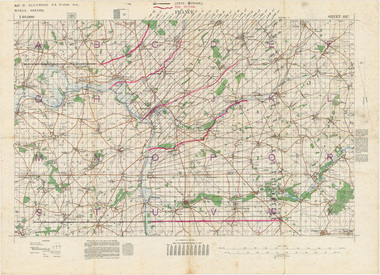
MAP TO ACCOMPANY HEAVY ARTILLERY SCHEME FOR MOBILE WARFARE".....marked with 'Lanes' and Corps/Division Boundaries, Ordnance Survey, 1:40,000, France. Sheet 62c, Dec 1917. (centring on Peronne and Mont St Quentin), December 1917
Shows detail of Artillery Planning in the area of Peronne & Mont St Quentin. Inscribed "Map to accompany H.A. Scheme for Mobile Warfare". Marked with 'Lanes' and Corps/Division Boundaries.The donor, Staff Sergeant R.O. (Bob) Snape, Reg No 8651, enlisted as a Stretcher Bearer in 1915 but, because of his secretarial skills was employed in HQ positions as soon as he arrived in France and as a stenographer who worked as Confidential Clerk to General Sir John Monash from June to December 1918; and subsequently, for General Sir Talbot Hobbs until June 1919. The map was very likely directly used in the planning of the 1918 battles such as Mont St Quentin.Original Item recovered from possibly Australian Corps HQ, probably between the Armistice, 11 November 1918, and June 1919, when Staff Sergeant R.O.(Bob) Snape was repatriated. Shows detail of Artillery Planning in the area of Peronne & Mont St Quentin. Inscribed "Map to accompany H.A. Scheme for Mobile Warfare". Marked with 'Lanes' and Corps/Division Boundaries.snape collection -
 Greensborough Historical Society
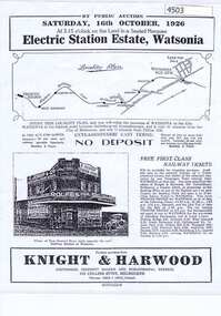
Advertising Leaflet, Electric Station Estate; Watsonia; Saturday 16th October 1926, 16/10/1926
This is one of two brochures advertising the auction of the last 50 allotments of the Electric Station Estate, Watsonia, near the new railway station. This brochure contains a locality plan and drawing of the general store. (Refer 4526 for the other brochure for this auction) Auctioneer: Knight & Harwood.One page B & W Photocopy (laminated) of auction brochure, with drawing of general store and locality planwatsonia railway station, watsonia, electric station estate -
 Ballarat Diocesan Historical Commission
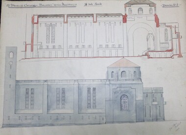
sketch, Architectural rendering for new St Patrick's Cathedral Ballarat
Rendering of proposed new cathedral for Ballarat by J. C. Hawes but never executed. Hawes designed many church buildings in Australia, West Indies, USA and UK. This image is one of a large suite of plans and drawings held in the archive.One of a series of large format sketches and proposed plans for a new cathedral at Ballarat by architect priest J.C.Hawes in 1944.Captioned St Patrick's Cathedral Ballarat, Victoria Australia 1/8 Inch Scale - Drawing No 2- and signed Lower Right John C Hawes Architect 1944. -
 Federation University Historical Collection
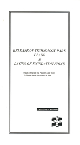
Programme, Release of Technology Park Plans and Laying of Foundation Stone, 1995, 02/1995
The Ballarat Technology Park site consists of 28.8 hectares of freehold land zoned for technology Purposes. The development plan for the Park was prepared by the City of Ballarat. The construction of the ISSC Southern Regional Data Centre was the first stage of the project. ISSC Southern Regional Data centre is a $12.5 million building development at the corner of Geelong Road and gear Avenue. The building was constructed by H. Troon Pty Ltd. White card program for the Release of Technology Park Plans and Laying of Foundation Stone. ballarat technology park, issc southern region data centre, troon, david james, geoffrey blainey, bruce clark, john bligh, roger hallam, campus plan -
 Melbourne Tram Museum
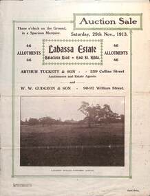
Ephemera - Real estate sale, Arthur Tucett & Son, "Labassa Estate" - Balaclava Road, East St Kilda, Nov. 1913
Pamphlet advertising the sale of land at the Labassa Estate, Balaclava Road 29-11-1913. Promotes the tram service, St Kilda Esplanade with a photo of PMTT 15 at the entry to Labassa at the corner of Orrong Road and Balaclava Road. Has a plan for the sub-division in to 46 allotments, terms of sale, and restrictions of what could be built on the land. The original Labassia Mansion is now owned by the National Trust.Demonstrates the style of land sale pamphlet including the availability of tram services to prospective purchasers.Pamphlet - folded - printed in two colours of cream coloured paper with photographs and plans.sale of land, trams, balaclava, balaclava road, real estate, labassa, orrong road -
 Kew Historical Society Inc
Plan - Subdivision Plan, Tregarron Estate, Kew, c.1929
Pru Sanderson, in her groundbreaking ‘City of Kew Urban Conservation Study : Volume 2 - Development History’ (1988), summarised the periods of urban development and subdivisions of land in Kew. The periods that she identified included 1845-1880, 1880-1893, 1893-1921, 1921-1933, 1933-1943, and Post-War Development. These periods were selected as they represented periods of rapid growth or decline in urban development. An obvious starting point for Sanderson’s groupings involved population growth and the associated economic cycles. These cycles also highlighted urban expansion onto land that was predominantly rural, although in other cases it represented the decline and breakup of large estates. A number of the plans in the Kew Historical Society’s collection can also be found in other collections, such as those of the State Library of Victoria and the Boroondara Library Service. A number are however unique to the collection.Subdivision plans are historically important documents used as evidence of the growth of suburbs in Australia. They frequently provide information about when the land was sold on which a built structure was subsequently constructed as well as evidence relating to surveyors and real estate and financial agents. The numerous subdivision plans in the Kew Historical Society's collection represent working documents, ranging from the initial sketches made in planning a subdivision to printed plans on which auctioneers or agents listed the prices for which individual lots were sold. In a number of cases, the reverse of a subdivision plan in the collection includes a photograph of a house that was also for sale by the agent. These photographs provide significant heritage information relating house design and decoration, fencing and household gardens.In January 1929, the Kew City Council called for tenders to construct Tregarron Avenue. The subdivision of the Tregarron Estate in Kew was for 11 lots bordering Tregarron Avenue and its entrance from Burke Road. The plan includes annotations that indicate the measurement of each block and the placement of the drainage and sewerage easements. This plan is interesting for a number of factors. The house blocks today have different street numbers, some blocks were to be further subdivided, and at the time of the subdivision, alterations were still being made to the extent of lots offered; lots 2 and 3 on the plan were subdivided and reoriented.subdivision plans - kew, tregarron estate, tregarron avenue -- kew (vic.), burke road -- kew (vic.) -
 Bendigo Historical Society Inc.
Plan - MARKS COLLECTION: SIDE AND FLOOR PLAN FORTUNA VILLA
Laminated plan, hand coloured, with side elevations and floor plans of Fortuna Villa entrance area. Basement, ceiling and first floor plans, with side elevations labelled Section A,B and (front view ) Section C,D. On bottom of plan signed 'W. Beebe Architect' and 1/4' equals 1 foot.bendigo, buildings, fortuna villa -
 Kew Historical Society Inc
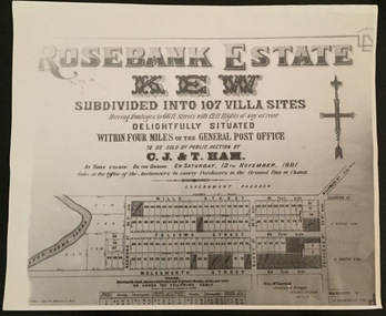
Plan - Subdivision Plan, Rosebank Estate, Kew, 1960-1973
This work forms part of the collection assembled by the historian Dorothy Rogers, that was donated to the Kew Historical Society by her son John Rogers in 2015. The manuscripts, photographs, maps, and documents were sourced by her from both family and local collections or produced as references for her print publications. Many were directly used by Rogers in writing ‘Lovely Old Homes of Kew’ (1961) and 'A History of Kew' (1973), or the numerous articles on local history that she produced for suburban newspapers. Most of the photographs in the collection include detailed annotations in her hand. The Rogers Collection provides a comprehensive insight into the working habits of a historian in the 1960s and 1970s. Together it forms the largest privately-donated collection within the archives of the Kew Historical Society.Rosebank Estate (Kew). A photographic reproduction of a plan in the Vale Collection of the State Library of Victoria made for the historian Dorothy Rogers. This plan is a later version of the original subdivision plan after a number of lots had been sold.rosebank estate (kew), studley park, thomas ham, c.j. & t. ham, rosebank estate, kew, wills street, barry street, fellows street, redmond street, molesworth street, thomas wills, wills family -
Port Melbourne Historical & Preservation Society
Card - PMHPS Registration Card No 1, Margaret Bride, 30 Aug 1994
Museums Australia had given PMHPS volunteers a workshop instructing on catalogue procedure. PMHPS was working in the disused classrooms of the former St Josephs Primary. The plans were the first items catalogued.Registration card No1: Plan of Edwards Park, being the first item catalogued by volunteers of the PMH&PS 30 August 1994.societies clubs unions and other organisations, port melbourne historical & preservation society, pmhps, margaret bride nee polson, edwards park -
Port Melbourne Historical & Preservation Society
Plan - Pool Street from Nott Street to Princes Street, Engineering Department, Town of Port Melbourne, 14 Mar 1893
Plan for Pool Street from Nott Street to Princes Street Loan Works 1893 plan 18; relates to specification 97.1Signed by JJ Bartlett (Mayor) 14.3.1893engineering - roads streets lanes and footpaths, town planning, town clerks, mayors, arthur victor heath, james john bartlett -
Port Melbourne Historical & Preservation Society
Plan - Ingles Street, Port Melbourne, 12 Jan 1866
Plans for Ingles Street showing both ground plan and longitudinal and traverse sections at Station Place, Heath, Nott and Bay Streets.Signed by surveyor Chas. Clay and James Bibby plus Thomas (Reek) Warren as witness to latter sig. Also a no: 355/H1 added later.engineering - roads streets lanes and footpaths, charles clay, thomas (reek) warren, james bibby -
University of Melbourne, Burnley Campus Archives
Plan, Redevelopment of the Rose Garden, 2002
Assignment by Student NB:501086 includes Plan, Scale 1/100 and Axonometric Drawing from Plan View 1/100.rose garden, burnley gardens -
 Bendigo Historical Society Inc.
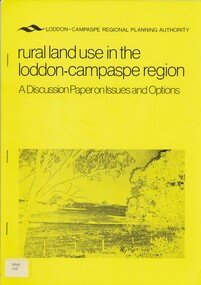
Book - RURAL LAND USE IN THE LODDON-CAMPASPE REGION, 1976
RURAL LAND USE IN THE LODDON-CAMPASPE REGION - a discussion paper on issues and options. 30 pages, with maps.Loddon-Campaspe regional planning authoritybook, rural, land use, loddon campaspe, rural, land use, agriculture -
 Federation University Historical Collection
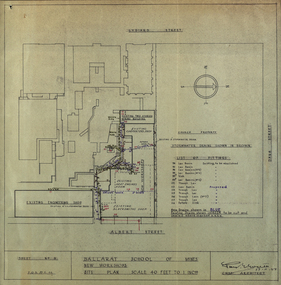
Plan - Plans, Ballarat School of Mines New Workshops, 1944, 17/11/1944
This building has been demolished to make way for new buildings along Albert Street. According to E.J. Barker this was Metal Fabrication.Plans (dyeline) for new building along the Ballarat School of Mines Albert Street frontage .1) Ballarat School of Mines New Workshops .2) as above Scale 1:480 WGS 84 37 degrees 33 feet 54 inches south 143 degrees 50 feet 30 inches eastSheet No 3 F.G.B.ballarat school of mines, metal fabrication, albert street, buildings, plan, heat engines room, model mine, blacksmiths shop, blacksmithing, carpenters shop, engineering shope, percy everett -
University of Melbourne, Burnley Campus Archives
Plan - Photocopy, Sunshine Planning Scheme, 1993
Photocopies. 18.02.1993. (1) 5 copies Map User Guide - Sunshine Planning Scheme. List of Zones, Reservations and additional Planning Controls. (2) Sunshine Planning Scheme - Local Section. Zones and Reserved Land Map No 2. (3) Map No 3. (4) Map No 4. Used in planning Native Garden Woodlandsunshine, reservations, native garden -
University of Melbourne, Burnley Campus Archives
Plan, David Reid, Dandenong College of T.A.F.E. Landscape Design, 1988
Student plans. (1) Master Plan by David Reid for Landscape Graphics 4, dated 17.10.1988. Scale 1:250. (2) Master Plan No 2 by L. Garnett October 1988. Scale 1:250. (3) Master Plan by Steve Soso for Landscape Graphics 4 dated 18.9.88. Scale 1:250.david reid, steve soso, landscape design -
 University of Melbourne, Burnley Campus Archives
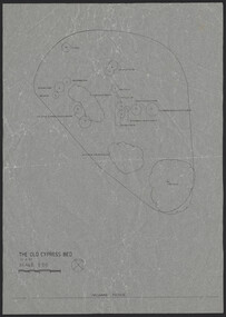
Plan, The Old Cypress Bed, 1987-1993
(1) Plant plan dated 15.8.1987 on tracing paper, and plan of bed only. (2) Site inventory and analysis Group 3 Parks and Gardens III August 1993, on tracing paper. (3) Rough plant plan in pencil.gardens, cypress -
 Kew Historical Society Inc
Plan - Subdivision Plan, Kew Golf Links Estate, 1936, 1936
The Kew Golf Links Estate was a major subdivision in North Kew. It derived its title due to the land being previously occupied by the Kew Golf Club, which transferred its course to a number of locations before occupying its current site. The Plan advertises 180 choice home sites. The street names are somewhat different today as those on the map are named after the proposed Kodak Factory to be built on the site. The subdivision of the Kew Golf Links Estate was a major subdivision of farmland in Kew. The site was at one stage designated for industrial development and the building of a new Kodak factory. The decision by Council to oppose the redevelopment makes the beginning of the period when all industrial development was banned in Kew.Monochrome printed, folded subdivision plan for the Kew Golf Links Estate, to be auctioned on 7 November 1936. Streets named include: Carnegie Avenue, Willsmere Road, Kilby Boulevarde, Kodak Avenue, Coleman Avenue, Beresford Avenue, McConchie Avenue, Cole Avenue, White Avenue, Baker Avenue, Spruzen Avenue, Tanner Avenue, Ratten Avenue, Mathers Avenue, Railway Avenue, Sutherland Avenue, and Belford Road. The position of the Yarra River and a large Drainage Reserve are marked on the plan. Lots for sale are numbered. Existing buildings are designated with a square.subdivision plans - kew (vic), kodak factory - kew (vic) -
 Federation University Historical Collection
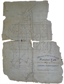
Plan, Eugene Bellairs, Moorabool Creek, Parish of Kerrit-Bereet, 01/08/1855
Plan of the Moorabool Creek on the Melbourne Roadmoorabool, kerrit-bareet, moorabool creek, eugene bellairs -
 Federation University Historical Collection
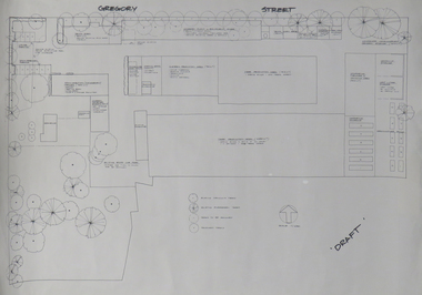
Plan, Ballarat School of Mines Horticulture Centre, Gregory St, Ballarat
Plan for the Gregory Street Horticulture Centre.ballarat school of mines, horticulture, school of horticulture, horticulture building, gregory street, architectural plan -
Port Melbourne Historical & Preservation Society
Plan - Furniture, Council Chamber, Port Melbourne Town Hall, Port Melbourne City Council, 8 Jul 1938
Plan for Council Chamber furniture, 1938port melbourne town hall, city engineers, fred cook -
Port Melbourne Historical & Preservation Society
Plan - Footbridge, Borough of Sandridge, 1860 - 1884
Plan for a footbridge, Borough of Sandridge, undated.Signed by Charles Clay and Gordon Fyfe.built environment - civic, charles clay, gordon fyfe -
University of Melbourne, Burnley Campus Archives
Plan, BHP Plaza 120 Collins St Melbourne, c. 1990
Possibly student workSketch plan. Scale 1:100.bhp, architecture -
 Orbost & District Historical Society
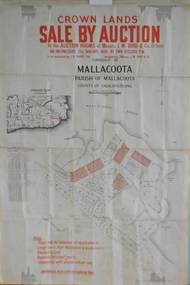
maps, early 1900s
796.1 - Crown Land Sale by auction in the township of Mallacoota on Wednesday January 1920 at 2pm. 796.2 - Snowy River farms , 630 acres of river flat land at Orbost on Wednesday April 28, 1909 at 2.30pm. 796.3 - Famous Orbost Flats - "Important Sale of Snowy River Land" , 900 acres subdivided into 13 choice farms on Wednesday 1st December 1920 at 2.30pm. 796.4 - "Second Great Sale in James' Subdivision", adjoining town of Orbost on 16th May, 1919 at 2pm. 796.5 - "Subdivisional Sale Brooklands Estate", 5 rich Snowy River farms on Wednesday 23rd February at 2.30 at Orbost on account of James Hossack Esq. 796.6 - "Subdivisional sale of Splendid Residence Sites and Handy Small Paddocks" adjoining the progressive town of Orbost on 5th March 1915 at 11am at the rooms of H.James & Co. 796.7 - This is a contract drawing on waxed paper. Crossing near Harbecks Cunninghame Signed and traced N. Anderson 17/11/00. 796.8 - A plan and specification on waxed paper. Shire of Orbost Cunninghame Road - signed by the shire engineer. 796.9 - This is a hand drawn map of Orbost Cunninghame Road, November 1896. 796.10 - This is a hand drawn cross-section of a culvert on the Orbost Cunninghame Road. 796.11 - This is a plan of a culvert on Tabbara Road, 13th January 1899 796.12 - This is a poster for an "Important Subdivisional Sale' for land near Orbost Bridge, on Wednesday 16th March 1921 at the rooms of H. James & Co. These documents are an important part of Orbost history in that they show how the town and surrounding areas were subdivided for farming and residential settlement.A set of twelve maps, plans and land sale posters .orbost-land-1900s maps posters h.james -
 Bendigo Historical Society Inc.
Plan - BERT GRAHAM COLLECTION: BENDIGO EAST SWIMMING POOL
Plans, Bert Graham Collection, Bendigo East Swimming Pool, 2 plans for the Kiosk. This item is quite large and has not been scanned.bendigo, clubs, bendigo east swimming pool -
 Bendigo Historical Society Inc.
Plan - BERT GRAHAM COLLECTION: BENDIGO EAST SWIMMING POOL
Plans, Bert Graham Collection, Bendigo East Swimming Pool, plans for the Pool. 4 quite large sheets too big to scan.bendigo, clubs, bendigo east swimming pool -
Whitehorse Historical Society Inc.
Map, Proposed Mitcham Shopping Centre, 1979
Proposed shopping complex of Mitcham.Proposed shopping complex of Mitcham - site plan and ground floor tenancy layout. Four stages of development for this shopping centre by Clarke Hopkins and Clarke Architects included.Proposed shopping complex of Mitcham.mitcham shopping centre, city of nunawading, coles supermarket, mitcham -
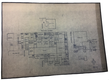 National Wool Museum
Archive - Architectural Plan, Plant Layout: R S & S Mill, 1973
Site plan of the R S & S Mill, 1st Dec, 1973.Architectural drawing on paper showing hand written diagrams and text. PE/C - 389textile mills - design textile mills - history, textile mills - design, textile mills - history, returned soldiers and sailors mill, r s & s mill, architecture, plan, site plan -
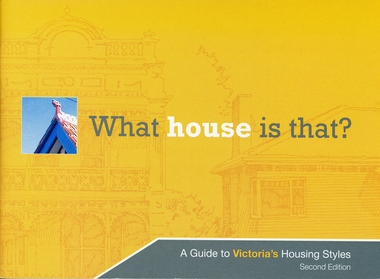 Ringwood and District Historical Society
Booklet, What house is that? A Guide to Victoria's Housing Styles
The Heritage Council was the funder of the project and it was produced by the Department of Planning and Community DevelopmentYellow covered booklet with photographs and printing of design features with coloured schemes for houses from Early Victorian to Post War Modern. 31 pages forward by Hon. Justin Madden MLC Minister for planning. -
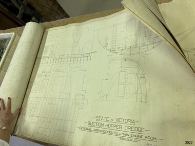 Flagstaff Hill Maritime Museum and Village
Plan - Vessel, Public Works Department (P.W.D.), Matthew Flinders I, 8-11-1911
These plans are line drawings by the State of Victoria for a Suction Hopper Dredge, which used a suction pump to bring up material from the bottom of a body of water. The plans are contained in a box from the Public Works Department, Ports and Harbours Division in Melbourne, which in the year 1910 was responsible for the dredging operations of coastal ports and harbours, and inland waterways. The stamped signature is that of Arthur Edward Cutler, Chief Engineer, Public Works Department of New South Wales. The steel steamer Matthew Flinders was constructed by Morts Dock & Engineering Co Ltd in Sydney, New South Wales. Identified as Ship No. 40 by the ship builders, this dredge, had twin screw engines that were made in Sydney. Its gross tonnage was 1180. It was launched on July 15th, 1916, and registered by the owner, Department of Public Works in Victoria, at the Port of Melbourne in 1917. Unlike bucket dredges, the Matthew Flinders did not use permanent moorings but instead had bow and stern anchors. It travelled forward on the bow anchor, taking up a strip of even-depth wilt from the bed below. A local newspaper noted that the Matthew Flinders has many advantages that were especially useful for its work at Warrnambool. Warrnambool Harbour had been experiencing silting and sanding for many years. The problem continued even after the construction of the Breakwater in 1890, which was overseen by New Zealand engineer Arthur Dudley Dobson. Melbourne’s Department of Ports and Harbours sent the new Matthew Flinders to dredge the heavy silting in the Warrnambool Harbour in May 1919. This work was previously done by the smaller dredge, the Pioneer. However, after a month of work, the Matthew Flinders was returned to Melbourne for alterations to make it suitable for work in the heavy seas it experienced at Warrnambool. Both dredges were sent up from Melbourne when required over the years to periodically attend to the silting in the Harbour, but the Matthew Flinders was preferred because of its efficiency. It was still dredging the Harbour even in July 1938. The ship’s original master was J G Rosney. In 1923 the master in charge was Captain Dunbar. In 1930 the dredges were no longer required as the Harbour was no longer suitable as port.These plans are significant for their close association with the suction hopper dredge, the Matthew Flinders I, which was call upon often to remove the silting of Warrnambool Harbour and allow shipping to continue in the Port of Warrnambool until 1930, when the Port of Warrnambool ceased to be suitable as a port. The work done by the Matthew Flinders is significant for its association with the Warrnambool Breakwater and the on-going issues with the silting of the Harbour. Plans with line drawings for the suction hopper dredge Matthew Flinders, rolled, in open-top wooden box. Created for the Public Works Department, Melbourne, Victoria. Stamped with signature and dated November I, 1911. Inscriptions: label on box, handwriting on box, drawings and outer layer of paper. Freighted by 1 Star, New Zealand Express Cargo.Signature stamp “A E Cutler” Date stamp “NOV 8 – 1911” Printed on one page “STATE OF VICTORIA / SUCTION HOPPER DREDGE / GENERAL ARRANGEMENTS OF MAIN ENGINE ROOM / SCALE 1/2 IN = 1 FT.” Label on box "1 [star symbol] / THE NEW ZEALA- - - / EXPRESS CAR - –“ Handwritten on base “PUBLIC WORKS / DEPARTMENT / - - LBOURNE” Handwritten in pencil on cover paper “MATTHEW Flinders”flagstaff hill, warrnambool, maritime village, maritime museum, flagstaff hill maritime museum & village, shipwreck coast, great ocean road, plan, line drawing, dredge, pioneer, steel steam ship, twin screw engines, a e cutler, arthur edward cutler, chief engineer, public works department, new south wales, nsw, 1911, state of victoria, suction hopper, main engine room, public works melbourne, warrnambool harbour, lady bay, sanding, silting, breakwater, morts dock & engineering co ltd, j g rosney, captain dunbar, ship no. 40, matthew flinders i, matthew flinders, 1 star, new zealand express cargo