Showing 10617 items
matching sites
-
 Lakes Entrance Regional Historical Society (operating as Lakes Entrance History Centre & Museum)
Photograph, 1935 c
Also and enlarged copy of same photograph 05347.1 10 x 13 cmBlack and white photograph of Steve and Sis Tunks with Jack and June Fish standing at a site showing a crane and several large rocks and part of tramline possibly North Arm Lakes Entrance Victoriacelebrations, genealogy -
Stawell Historical Society Inc
Archive, Archives from Pleasant Creek Training Centre
-1 Large Ledger 1943 Tools & Consumables for Manual Training Class. -2 Pleasant Creek Special School, School Policy and Curriculum 1947 -3 2 X WEL magazines 1983 -4 Test Material for the Measurement of Intelligence -5 Invitation for registration of expression of interest for Former Pleasant Creek Centre at Western Highway Stawell.Large Green Ledger with Brown Spine. Yellow covered Book with black binding combs. Two A3 Sized Negative Booklets. Two sets of Intelligence Test Material. Expression of Interest for site.education -
 Whitehorse Historical Society Inc.
Photograph, Narmara Primary School, 13/01/1994 12:00:00 AM
Coloured photo of Narmara Primary School, Namara Street, looking North. School on North side of Highbury Road, between Middleborough Road and Blackburn Road. Since demolished and site developed for housing.narmara primary school, warner, philip -
 Whitehorse Historical Society Inc.
Photograph, Narmara Primary School, 13/01/1994 12:00:00 AM
Coloured photo of Narmara Primary School, looking West along Highbury Road. School on North side of Highbury Road between Middleborough and Blackburn Roads. Since demolished and site developed for housing.narmara primary school, warner, philip -
 Whitehorse Historical Society Inc.
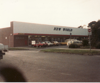
Photograph, Front Facade Coles New World Supermarket, Mitcham, 13/06/1986 12:00:00 AM
2 Coloured photos of Front Facade Coles New World Supermarket, Brittania Street, Mitcham. Formerly site of Mitcham State School.Prior to the redevelopment of Britannia Mall and construction of 3 level carpark.mitcham state school, no. 2904 -
Whitehorse Historical Society Inc.
Pamphlet, Hill 60 Estate, 13/04/1957 12:00:00 AM
Auction of 64 homes sites in the last section of Hill 60 Estate to be auctioned by Frank Fisher & Co. on 13 Apr 1957.Auction of 64 homes sites in the last section of Hill 60 Estate to be auctioned by Frank Fisher & Co. on 13 Apr 1957. There is also a Drake & Co. Pty Ltd sticker on page 4.Auction of 64 homes sites in the last section of Hill 60 Estate to be auctioned by Frank Fisher & Co. on 13 Apr 1957. hill 60 estate, forest hill, hill 60 estate, tunstall, frank fisher co., drake co. -
 Whitehorse Historical Society Inc.
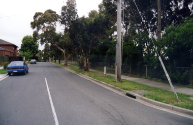
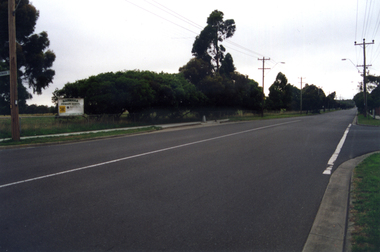
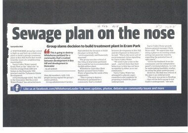
Article, Sewage Plan, 2018
Yarra Valley Water named Eram Park as the 'ideal site' to recycle sewage from 5500 new homes in the Doncaster Hill precinct and Tullamore Estate development, but local residents are totally opposed it.sewerage and sanitation, yarra valley water, city of whitehorse, eram park -
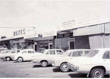 Whitehorse Historical Society Inc.
Photograph, White's Shopping Centre, 1/09/1976 12:00:00 AM
Black and white photo looking south along White's Shopping Centre, Mitcham Road, Mitcham - alongside Railway line. Was site of Orm White's hay and corn store and family home adjacent.whites shopping centre -
Bialik College
Document (Item) - Speech titled Bialik College and its role in the community by Mena Kozminsky
Speech titled Bialik College and its role in the community by Mena Kozminsky. No date provided. Directed towards parents and the role of media in the framing of education in Australia. education, bialik college, judaism -
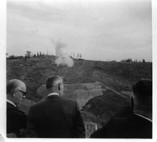 Southern Sherbrooke Historical Society Inc.
Photograph - The official party watch the first blasting at Cardinia Reservoir
Three members of the official party watch on as the 'first' blasting takes place at Cardinia Reservoir, May 1970. It is clear from the extensive earthworks below the blast site that work has already commenced. -
 Ballarat Tramway Museum
Domestic Object - Fridge Magnet, mid 1990's?
Fridge Magnet, featuring a photo image of Ballarat No. 26, with details of the Museum alongside, including phone number, web site and location. Yellow background. Made by Mister Magnets. 2 copies held. trams, tramways, btm, sales, fridge magnet, ballarat vintage tramway -
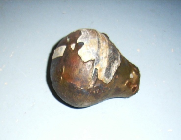 Queenscliffe Maritime Museum
Lead Weight
"Loch Ard" Iron 3-mast ship wrecked 31st May 1878 Port Campbell Pear shaped lead weight with brass casing recovered from Loch Ard wreck site. -
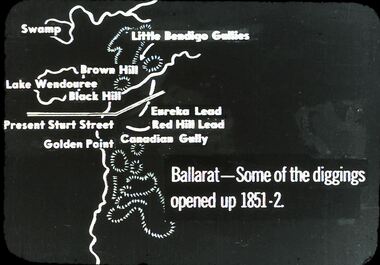 Bendigo Historical Society Inc.
Slide - DIGGERS & MINING: THE DIGGINGS - THE DIGGERS
Diggers & Mining: The Digging - The Diggers. Slide depicting landmarks and mining sites in Ballarat. Some of the diggings opened up 1851-2. Markings:10 994.LIF:6. Used as a teaching aid.hanimounteducation, tertiary, goldfields -
University of Melbourne, Burnley Campus Archives
Work on paper (item) - Student Work, Luke Flanagan, Marriott Residence Landscape Design, 2016
Submitted as an assignment for HORT90035, 'Landscape Construction and Graphics,' coordinated by Andrew Laidlaw. assignment, landscape construction and graphics, landscaping, hort90035, burnley horticultural college -
Canterbury History Group
Ephemera - Payne's Paddock, Canterbury, 1918
Copy of the original brochure for the auction on 28th September 1918, of the78 building sites comprising Payne's Paddock by W.F. Vale and Co. Auctioneers. Reproduced by Sinclair and Co. to advertise their market appraisal of the area.paynes paddock, canterbury, highfield road, leura street, payne street, tyndall street, keneally street, w.f.vale and co., sinclair and co., land subdivision -
Canterbury History Group
Ephemera - "Haslemere" 137 Mont Albert Road, Canterbury, 1997
Real estate advertisement for auction of "Haslemere" (c1889) 137 Mont Albert Road Canterbury, on 22nd November 1997. Includes coloured photographs of exterior and interior, architectural features, and floor and site planscanterbury, mont albert road, fireplaces, lead lights, victorian style, jellis craig and company, haslemere -
Canterbury History Group
Ephemera - 207 Canterbury Road Canterbury, 2003
Real estate advertisement for the sale by auction of shop at 207 Canterbury Road Canterbury on Thursday 27 March 2003. Includes coloured photographs of the exterior and Canterbury Road, floor plans and site plan.canterbury, canterbury road, shops, nomlas house -
Canterbury History Group
Document - Tour of Camberwell Grammar School, 2113
Handout of history of the Camberwell Grammar School and the mansions the school has on site, prepared by Trevor Hart archivist of the school on the occassion of a tour he conducted for the Canterbury History Group 23 September 2113canterbury, camberwell grammar school, hart> trevor, highton, doery> george henry, camberwell convalescent home for soldiers, world war 1914-1918, tara, christie> louis p, roystead, vial> oliver, kingussie, lumsden> david, norge, gunnersen> thorald william, world war 1939-1945, lindrum> walter, mont albert road -
Canterbury History Group
Pamphlet - Range Estate, Canterbury, 1/04/1916 12:00:00 AM
Photocopy of a Coghill & Haughton brochure advertising the sale by auction of '19 superb Villa and Mansion' sites in Canterbury on 15 April 1916. Includes map of the allotments and photographs of five existing homes on the estate.canterbury, balwyn road, hopetoun avenue, mont albert road, view street, coghill & haughton, land sales, grange estate, auctioneers -
 Falls Creek Historical Society
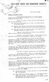
Document - Circular To Licence Holders & Others Interested In Committee Plans, 05.09.1963
Bob (Herman) Hymans (a former member of the Royal Netherlands Navy) was born in Bloemendaal, Holland on 30th September 1922. During World War II he fought against the Japanese in the Dutch East Indies (now Indonesia) and was imprisoned in Changi and on the Burma Railway. After gaining qualifications as a Ski Instructor, Bob arrived in Falls Creek in July 1950. Working as an Instructor and Supervisor at Bogong Lodge, Bob decided his future was in accommodation. He was successful in negotiating an indenture for land from the State Electricity Commission (SEC). It took Bob two years to build his Grand Coeur Chalet but, tragically, it was burned down in August 1961. Bob also built the first Chairlift in Australia. This was a single chairlift and the structure was built from wooden electricity poles. He was constantly full of new ideas and proposals for the village. Bob Hymans die on 7th July 2007. This Collection of documents and letters tells the story of Bob's endeavours to develop Falls Creek into the ski village it is today.This letter is significant because it documents developments made or endorsed by the Falls Creek Tourist Area Management Committee.A circular from the Management Committee outlining their plans for the development of the Falls Creek Tourist Area. This included completion of the Gully Chairlift, earmarking sites for cafes and restaurants and improvement in public facilities and medical services.falls creek tourist area management committee, falls creek administration -
Canterbury History Group
Ephemera - Maling's Tramway Estate, 1924
Brochure for the auction on Saturday 13 December 1924 of 40 home sites comprising Maling's Tramway Estate, Balwyn. Includes photographs of Whitehorse and Balwyn Roads corner, and two houses on the border of the estate.balwyn, malings tramway estate, land sales, land subdivision, whitehorse road, arthur tuckett & son, geo. m hume -
 Melbourne Tram Museum
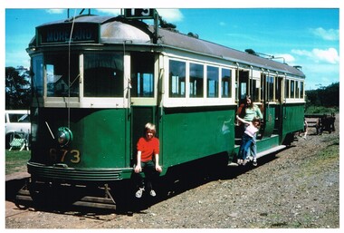
Photograph - Colour Photograph/s, John Phillips DOI, mid 1990's
.1 - Colour print of W4 673 at TMSV site Bylands, mid 1990's. Tram has the destination of "Moreland". Photographed by John Phillips for the Dept. of Transport. Printed on Kodak or Fujifilm paper.Each photo has on the rear a "Copyright Department of Infrastructure with details for reordering and a hand written letters "JP"trams, tramways, tmsv, bylands, w4 class, tram 673 -
 Bendigo Historical Society Inc.
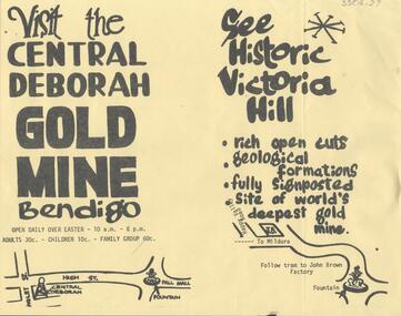
Document - CENTRAL DEBORAH GOLD MINE: ADVERTISING FLYER
BHS CollectionA4 advertising flyer,yellow background, black text. 'Visit the Central Deborah Gold Mine Bendigo' 'See Historic Victoria Hill'. Handrawn mud maps for each site on bottom of page.bendigo, mining, crentral deborah gold mine -
 Melbourne Tram Museum
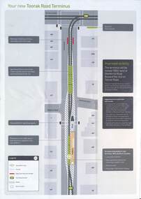
Pamphlet, Public Transport Victoria (PTV), Your New Look Toorak Road Terminus, 2015
Promotion by PTV of upgrade to unsafe terminus on a busy road. It followed similar upgrades to a number of other termini and preceded the combining of routes 8 and 55 into route 58 in 2017. The modern E class trams that feature on the cover did not commence operating on route 58 until late 2021.Shows that relatively high cost infrastructure is being installed on the tram network and that traffic priorities are changing with motor vehicle right of way being reduced in places for passenger and staff safety.Coloured fold out pamphlet DL size when folded, with large photograph of current tram terminus on half of one side. A site plan of the proposed completed modifications on all of the other side.Typed explanations throughoutterminus, network upgrade, platform stop, toorak, route 8, route 58 -
 Lakes Entrance Regional Historical Society (operating as Lakes Entrance History Centre & Museum)
Photograph, 2008
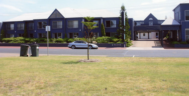
Date made August 2008Colour photograph Bellevue Complex showing driveway with a walk-over bridge. Car parked on road in front of complex. It is on the site of Vizes Bellevue and Police Station, situated on Esplanade, Lakes Entrance, Victoria.resort, transport, room display -
 Lakes Entrance Regional Historical Society (operating as Lakes Entrance History Centre & Museum)
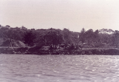
Photograph - Bullock Island, Fish Marie, 1995
Black and white photograph of Bullock Island. It shows the site of Peck's fish processing factory being cleared. Cunninghame Arm of lake in foreground, Kalimna Heights escarpment in background. Lakes Entrance Victoriaislands, historic site -
 Ringwood and District Historical Society
Photograph, Ringwood State School photograph for land sale - Bestpart Estate, Ringwood - 1925
Written on back of photograph, "State School, Greenwood Avenue. Foundation stone re-erected in Greenwood Avenue. Transferred from old site Ringwood Street and Whitehorse Road". -
 Ringwood and District Historical Society
Photograph, Herman Pump's orchard and home Heathmont - 1923 - in vicinity of Royal Avenue. House on Canterbury Road, later site of Uniting Church
Black and white photograph of orchard. House in top left of photograph.Typed on backing sheet below photograph, "Herman Pump's orchard and home Heathmont - 1923 - in vicinity of Royal Avenue. House on Canterbury Road, now site of Uniting Church". -
 Ringwood and District Historical Society
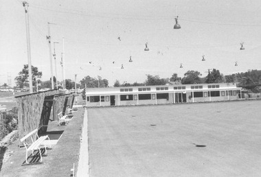
Photograph, Ringwood Bowling Club- New clubrooms, 1972
Black and white photograph"Written on back of photograph" Bowling green and new clubrooms. 22.11.72. Miles Avenue site. Clubrooms were built in 1968 after the old clubrooms were destroyed by fire. -
 Ringwood and District Historical Society
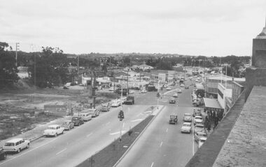
Photograph, Maroondah Highway West, Ringwood- 1962. Looking west from Town Hall
Black and white photograph (2 copies)Written on back of one photograph: "From Town Hall roof, Dec 1962. Image shows demolished site of Cool Stores on corner of Maroondah Highway and Wantirna Road.