Showing 2090 items
matching bendigo maps
-
 Bendigo Historical Society Inc.
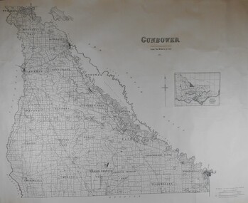
Map - JACK FLYNN COLLECTION: COUNTY OF GUNBOWER, 1935
... Inc. History House 11 Mackenzie Street Bendigo goldfields MAP ...Map; County of Gunbower. Sheet containing the whole of the County, showing parishes within. Scale 2 Miles to 1 inch.map, gunbower, parish plan, gunbower -
 Bendigo Historical Society Inc.
Map - JACK FLYNN COLLECTION: YARRAYNE, 6/01/1932
... Inc. History House 11 Mackenzie Street Bendigo goldfields MAP ...Map: Parish of Yarrayne, County of Bendigo. Parish plan.By Authority, H.J. Green, Govt., Printer. Photo-Lithographed at the Department of Lands and Survey, Melbourne. 5.1.32.map, bendigo, parish plan, yarrayne -
 Bendigo Historical Society Inc.
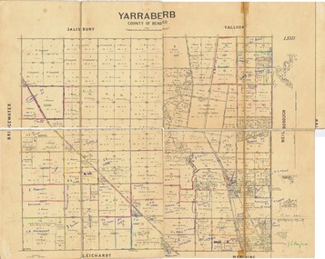
Map - JACK FLYNN COLLECTION: YARRABERB, NO date visible
... Inc. History House 11 Mackenzie Street Bendigo goldfields MAP ...Map: Parish of Yarraberb, County of Bendigo. Parish plan.By Authority H.J. Green. Govt., Printer.map, bendigo, parish plan, yarraberb -
 Bendigo Historical Society Inc.
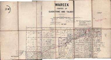
Map - JACK FLYNN COLLECTION: WAREEK, Examined 1918
... Inc. History House 11 Mackenzie Street Bendigo goldfields MAP ...Map: L.1053. Parish of Wareek, Counties of Gladstone and Talbot. Parish plan. Looks like half of the sheet is missing.Second Issue. Examined by S.F. Green. July 1918. William J. Swan, Draughtsman, August 1884. Photo-Lithographic Fac-Simile, W 36.map, gladstone, parish plan, wareek -
 Bendigo Historical Society Inc.
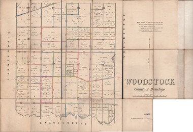
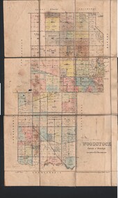
Map - JACK FLYNN COLLECTION: WOODSTOCK, 27/03/75
... Inc. History House 11 Mackenzie Street Bendigo goldfields MAP ...Map: Parish of Woodstock , County of Bendigo. Parish plan.Photo-Lithographed at the Department of Lands and Survey Melbourne by J. Noone. 27.3.79map, bendigo, parish plan, woodstock -
 Bendigo Historical Society Inc.
Map - JACK FLYNN COLLECTION: WOODSTOCK, 4/07/1935
... Inc. History House 11 Mackenzie Street Bendigo goldfields MAP ...Map: Parish of Woodstock, County of Bendigo. Parish plan.By Authority H.J. Green. Govt Printer. Drawn and Reproduced at the Dept of Lands and Survey, Melbourne Victoria. 4.7.35map, bendigo, parish plan, woodstock -
 Bendigo Historical Society Inc.
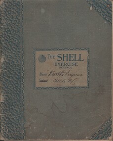
Document - MCCOLL, RANKIN AND STANISTREET COLLECTION: NORTH VIRGINIA GMC N L - CROSS SECTION PLAN OF THE MINE, 1942 1947
Document. Grey/green exercise book with 'North Virginia GMC NL. Book contains hand drawings of shafts and their metalurgical content at every depth. Symbols have been used to indicate different metals and earth. 2 maps loose in the book.McColl, Rankin & Stanistreetorganization, business, north virginia gmc n l, mccoll, rankin & stanistreet, north virginia gmc n l, gold mining, cross section plan of the north virginia -
 Bendigo Historical Society Inc.
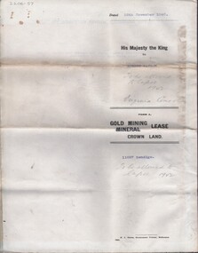
Document - MCCOLL, RANKIN AND STANISTREET COLLECTION: NORTH VIRGINIA GMC N L - TITLE DEED, 22/8/1950
... Virginia Gold Mining Co. Has 2 maps. No 11261 Bendigo. Vol 331... to North Virginia Gold Mining Co. Has 2 maps. No 11261 Bendigo. Vol ...Document. Coarse cream coloured paper typed but with hand written dates. Assistant Registrar of Titles. Made out to North Virginia Gold Mining Co. Has 2 maps. No 11261 Bendigo. Vol 331 Fol 36452McColl, Rankin & Stanistreetorganization, business, north virginia gmc n l, mccoll, rankin & stanistreet, north virginia gmc n l, gold mining, title deed -
 Bendigo Historical Society Inc.
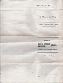
Document - MCCOLL, RANKIN AND STANISTREET COLLECTION: NORTH VIRGINIA GMC N L - TITLE DEED/LEASE, 30/11/1940
Document. Coarse cream coloured paper typed. Corrections and additions. Assistant Registrar of Titles. Made out to Robert Watson of Eaglehawk. Has map of lease in the back.McColl, Rankin & Stanistreetorganization, business, north virginia gmc n l, mccoll, rankin & stanistreet, north virginia gmc n l, r watson, gold mining, title deed/lease -
 Bendigo Historical Society Inc.
Document - VICTORIA HILL - VISITOR PLANS FOR VICTORIA HILL
Handwritten carbon copy of notes on 1st and 2nd stage plans for a tourist area on approx. 20 acres at Victoria Hill. First stage was to clean up the area, locate and sign post shafts, engine beds, etc and prepare a topographical map with these features on it. Second stage was to arrange for the purchase of typical miners homes and shops in the vicinity to be restored for inspection by visitors. Mining equipment to be placed in the area. Prepare brochures for sale. Set up a mining museum.Prepare an area near BCV 8 with direction finder to mining and general features, as this has the best natural ground level view in the City.mine, gold, victoria hill, victoria hill, visitor plans for victoria hill, darrel mcclure, bendigo city council, bendigo historical society, central nell gwynne, caleb thomas, bcv 8, lazarus, old chum, new chum, victoria, repeater station (p. m. g.) -
Bendigo Historical Society Inc.
Document - VICTORIA HILL - KEY TO SIGN POSTS ON AREA MAP
Three page hand written carbon copy of Sign numbers at Victoria Hill. No 1 North Old Chum Shaft, No 2 Ballerstedt's First Open - Cut. Special Sign Post, No 2 C Rock Formations Pitching North, No 2 B Rich shallow shafts, No 2 A Quartz veins, No 4 A Concrete Dams, No 3 Engine Beds - Lansell's 'Big 180' Mine, No 3 B Lansell's 'Big 180' Shaft, No 4 Twenty Stampers Crushing Battery, No 3 C Foundations - 'Cleopatra Needle' type Chimney for Lansell's 'big 180' Mine, No 5 Victoria Quartz Mine, No 5 A Fou;ndations Victoria Quartz Poppet Legs, No 5 C Foundations Victoria Quartz Winding Plant, No 5 B Victoria Quartz Dams, No 6 Rae's Open - Cut, No 9 Quartz Once Roasted Here, No 12 Anticlinal Arch, No 15 primitive Tunnels, No 14 Beautifully Coloured Rock Formations, No 16 Adit, Graded Bedding, Oblique Fault, Spurry Quartz Veins, No 17 Prospecting Tunnels, No 18 Floyd's Small Crushing Battery, No 19 Gt Central Victoria (Midway) Shaft, No 20 Great Central Victoria (Midway) Engine Bed, No 21 ballerstedt's Small 24 Yard Claim, No 22 Humboldt Shaft, No 23 Wittscheibe's 'Jeweller's Shop', No 24 The 'Adventure' ground, Large Open - Cut, No 26 Luffsman and Sterry's Ground, NO 27 A Round Shaft,mine, gold, victoria hill, victoria hill, victoria hill key to sign posts on area map, north old chum shaft, ballerstedt's first open cut, lansell's big 180 shaft, 'cleopatra needle' type chimney, victoria quartz mine, rae's open cut, prospecting tunnels, floyd's small crushing battery, gt central victoria (midway) shaft, ballerstedt's small 245 yard claim, humboldt shaft, wittscheibe's 'jeweller's shop', adventure, luffsman and sterry's ground, david sterry, sterry's 'gold mines' hotel, round shaft -
Bendigo Historical Society Inc.
Document - VICTORIA HILL - CLASSIFICATION REQUEST
... Bendigo Historical Society Inc. Bendigo Historical Society ...Handwritten, 3 page carbon copy of a classification request for victoria Hill. Notes give locality, housing program in the area, immediate surrounds of the area, prominent citizens, buildings, mines, geographical formations and gold production.mining, parish map, victoria hill, classification request for victoria hill, gold mines hotel, john brown knitwear factory, lansell's fortuna villa, army survey corp, housing commission, hercules, energetic, ironbark, manchester arms hotel, bendigo goldfield, old miners homes, george lansell, sir george lansell, bendigo advertiser, theodore ballerstedt junior, mr c t c johann ballerstedt, mr wm rae, david sterry, adventure, wittscheibe's 'jewellers shop', luffsman & sterry's rich claim, ballerstedt open cut and mine, lansells 180, victoria quartz, rotary club of bendigo south, bendigo cemetry -
Bendigo Historical Society Inc.
Document - TYSON'S LINE - EASTERN LINES
... Bendigo Historical Society Inc. Bendigo Historical Society ...Typed carbon copy of General notes on the lines East of the Hustlers. Lines mentioned are: Hustler's, New Chum, Lightning Hill, Tysons, Slaughteryard, Isabella Mine, Ironstone Hill Reef, Nicholson Reef, on which a mine ownede by a man named Stevenson mined a fair amount of gold. Ref. Anon; 1899. Spec. Ed. Aust. Min. Stand. June 1st 1899: p 61.mining, parish map, tyson's line, eastern lines, hustler's, new chum, slaughteryard line, lightning hill, tyson's, isabella mine, ironstone hill reef, nicholson reef, mr stevenson, aust min stand 1 june 1899 -
 Bendigo Historical Society Inc.
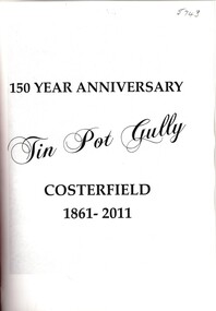
Book - TIN POT GULLY COSTERFIELD
150 year anniversary Tin Pot Gully Costerfield 1861 - 2011, a short history of Costerfield 35 pages with black and white photographs & a map. Red unmarked cover.N L Harrishistory, australian, costerfield -
 Bendigo Historical Society Inc.
Map - SNOB'S HILL - PLAN OF SNOB'S HILL MINES
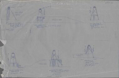
... Inc. History House 11 Mackenzie Street Bendigo goldfields MAP ...a. . Handdrawn copy of Snob's Hill Mines by Caleb Thomas (Long Section) 1885. Top drawing show mines and the distance between them. Lower drawing shows leases at a scale of 8 chains to 1 inch. Dams and sand heaps are included. The second page shows x-sections of the poppet legs and their heights. Shaft numbers are included. Two of the pulley diameters are also shown. b. Document headed Caleb Thomas cross sections 10.10.1884. South Catherine, engine east of shaft legs 44 ft high Ellenborough engine east of shaft, legs 40 feet Belmont and Saxby, engine and wheel west of shaft, legs 27 feet York and Durham, engine and wheel west of shaft legs 27 feet Snobs Hill , Old Williams, engine east of shaft legs 53 feet, L. Brace 21ft. 1884 Acadia Catherine engine west. Legs 44 feet, L.brace 11 ft.map, bendigo, goldfields, snob's hill, plan of snob's hill mines, caleb thomas, c reef united, catherine reef shaft, william's main, acadia, william's old main, gt northern, york & durham, snob's hill, belmont & saxby, ellenborough, st mungo, golden pyke, united c'holders, compy, snowdon & co, sth catherine coy, princess alice, saunders, williams & coy, acadia co, wearon & co, snob's hill, nelson trib, kneebone tribute, la belle co, york & durham, north st mungo, saxby & devonshire trib, n? trib, belmont co, durham c'land, kitti trib, sadowa trib, ran?eu co, nth devonshire co, lady barkly, devonshire reef trib, central devonshire co, j c macartney, catherine united -
Bendigo Historical Society Inc.
Map - SNOB'S HILL - PLAN OF SNOB'S HILL AREA
... Inc. History House 11 Mackenzie Street Bendigo goldfields MAP ...Plan drawn on tracing film of sand heap, dams, trig point and mines. Some un-named streets are also drawn in. Piece of notepaper has mines drawn in on a larger scale.map, bendigo, goldfields, snob's hill, plan of snob's hill area, new st mungo mullock heap, duchess trib, s devonshire, duchess of edinburough, w u devonshire, hopewell, phoenix, unicorn, princess alice, lady barkly, sadowa, e u devonshire, united devonshire, l?, ellenborough, belmont & saxby, snob's hill -
Bendigo Historical Society Inc.
Map - RED WHITE & BLUE EXTENDED - PLAN OF RED WHITE AND BLUE EXTENDED MINE TRANSVERSE SECTION
Transverse section of the Red White & Blue Extended Mine on the Sheepshead Line of Reef showing shafts, depths and geological features. Drawn on traqcing film in pencil. Signed by J J Caldwell, District Field Geologist, Mines Department, Bendigo and dated 5/12/1940.document, gold, red white & blue extended, red white & blue extended, plan of red white & blue extended mine transverse section, j j caldwell, mines dept bendigo -
Bendigo Historical Society Inc.
Map - VICTORIA, Circa 1926
... Inc. History House 11 Mackenzie Street Bendigo goldfields MAP ...Map: Map showing Counties, including Railway lines and Geographic features. Compiled and engraved at the Department of Lands and Survey Melbourne, Revised October 1926 ( number 184 in Map Cupboard 1)map, victoria, counties, counties of victoria, geographic features -
Bendigo Historical Society Inc.
Map - GEOLOGICAL MAP BENDIGO GOLDFIELD, See above
... GEOLOGICAL MAP BENDIGO GOLDFIELD...Map: Geological map of the Bendigo Goldfield comprising 2... Inc. History House 11 Mackenzie Street Bendigo goldfields MAP ...Map: Geological map of the Bendigo Goldfield comprising 2 sheets , Numbered 9358a and 9358b. Prepared in 1923 re-issued in 1936map, bendigo, geological, geological map, bendigo goldfield -
Bendigo Historical Society Inc.
Map - PASTORAL HOLDINGS, See above
... Inc. History House 11 Mackenzie Street Bendigo goldfields MAP ...Map: Copy of 'Map showing the Pastoral Holdings of the Port Phillip District 1835-51, Now Victoria'. Comiled by A.S.Kenyon M.I.E. Aus. Historical society of Victoria 1932map, victoria, pastoral holdings, pastoral holdings, port phillip district -
Bendigo Historical Society Inc.
Map - MINING PLAN, Circa 1880's
Mining Plan: showing the following companies: New Chum and Victoria Co., South Victoria Co., Lansell's 180, Victoria Quartz Mining Co.topic, mining, plans, mining in bendigo, new chum and victoria co., south victoria co., lansell's 180, victoria quartz ming co. -
Bendigo Historical Society Inc.
Map - NERRING, August 1952
... Map: Nerring, County of Bendigo. Parish plan ( number 180... Inc. History House 11 Mackenzie Street Bendigo goldfields MAP ...Map: Nerring, County of Bendigo. Parish plan ( number 180 in Map Cupboard 1)map, bendigo, parish plan, nerring, county of bendigo -
Bendigo Historical Society Inc.
Map - SALISBURY WEST, 14/10/1943
... Inc. History House 11 Mackenzie Street Bendigo goldfields MAP ...Map: Salisbury West, County of Gladstone. Parish plan ( number 179 in Map Cupboard 1)map, gladstone, parish plan, salisbury west , county of gladstone -
Bendigo Historical Society Inc.
Map - HAWKESTONE, 17/11/1915
... Inc. History House 11 Mackenzie Street Bendigo goldfields MAP ...Map: Hawkestone, County of Talbot. Parish plan ( number 178 in Map Cupboard 1)map, talbot, parish plan, hawkestone, county of talbot -
Bendigo Historical Society Inc.
Map - HARCOURT, September 1951
... Inc. History House 11 Mackenzie Street Bendigo goldfields MAP ...Map: Harcourt, County of Talbot. Parish plan ( number 177 in Map Cupboard 1)map, talbot, parish plan, harcourt, county of talbot -
Bendigo Historical Society Inc.
Map - PARISH OF LAANECOORIE, 13/10/1930
... Inc. History House 11 Mackenzie Street Bendigo goldfields MAP ...Map: Parish of Laanecoorie, County of Bendigo. Parish plan ( number 176 in Map Cupboard 1)map, bendigo, parish plan, laanecoorie -
Bendigo Historical Society Inc.
Map - KIMBOLTON, 24/05/1921
... Inc. History House 11 Mackenzie Street Bendigo goldfields MAP ...Maqp: Kimbolton, County of Bendigo. Parish plan ( number 175 in Map Cupboard 1)map, bendigo, parish plan, kimbolton -
Bendigo Historical Society Inc.
Map - LANGWORNOR SHEET 2, 26/06/1889
... Inc. History House 11 Mackenzie Street Bendigo goldfields MAP ...Map: Langwornor sheet 2, County of Dalhousie. Parish plan ( number 173 in Map Cupboard 1)map, dalhousie, parish plan, langwornor, county of dalhousie -
Bendigo Historical Society Inc.
Map - LANGWORNOR SHEET 1, No date visible
... Inc. History House 11 Mackenzie Street Bendigo goldfields MAP ...Map: Langwornor sheet 1, County of Dalhousie. Parish plan ( number 174 in Map Cupboard 1)map, dalhousie, parish plan, langwornor, county of dalhousie -
Bendigo Historical Society Inc.
Map - KIMBOLTON, No date Visible
... Map: Kimbolton, County of Bendigo. Parish plan ( number 172... Inc. History House 11 Mackenzie Street Bendigo goldfields MAP ...Map: Kimbolton, County of Bendigo. Parish plan ( number 172 in Map Cupboard 1)map, bendigo, parish plan, kimbolton